95 Image Results
Form:
drawings
drawings

Form:
drawings
drawings
Date:
17th century
17th century
People:
Form:
drawings
drawings

Form:
drawings
drawings
Date:
17th century
17th century
People:
Form:
drawings
drawings

Form:
drawings
drawings
Date:
17th century
17th century
People:
Form:
drawings
drawings

Form:
drawings
drawings
Date:
17th century
17th century
People:
Form:
drawings
drawings

Form:
drawings
drawings
Date:
17th century
17th century
People:
Form:
drawings
drawings

Actions:
Reference number:
DR1979:0045:002
DR1979:0045:002
People:
Date:
1819-1820
1819-1820
Form:
drawings
drawings
Date:
1819-1820
1819-1820
People:
Form:
drawings
drawings

Actions:
Reference number:
DR1979:0045:004
DR1979:0045:004
People:
Date:
1819-1820
1819-1820
Form:
drawings
drawings
Date:
1819-1820
1819-1820
People:
Form:
drawings
drawings

Actions:
Reference number:
DR1979:0045:006
DR1979:0045:006
People:
Date:
1819-1820
1819-1820
Form:
drawings
drawings
Date:
1819-1820
1819-1820
People:
Form:
drawings
drawings

Actions:
Reference number:
DR1979:0045:007
DR1979:0045:007
People:
Date:
1819-1820
1819-1820
Form:
drawings
drawings
Date:
1819-1820
1819-1820
People:
Form:
drawings
drawings

Actions:
Reference number:
DR1979:0045:001
DR1979:0045:001
People:
Date:
1819-1820
1819-1820
Form:
drawings
drawings
Date:
1819-1820
1819-1820
People:
Form:
drawings
drawings

Actions:
Reference number:
DR1979:0045:014
DR1979:0045:014
People:
Date:
1819-1820
1819-1820
Form:
drawings
drawings
Date:
1819-1820
1819-1820
People:
Form:
drawings
drawings

Actions:
Reference number:
DR1979:0045:012
DR1979:0045:012
People:
Date:
1819-1820
1819-1820
Form:
drawings
drawings
Date:
1819-1820
1819-1820
People:
Form:
drawings
drawings

Actions:
Reference number:
DR1979:0045:008
DR1979:0045:008
People:
Date:
1819-1820
1819-1820
Form:
drawings
drawings
Date:
1819-1820
1819-1820
People:
Form:
drawings
drawings

Actions:
Reference number:
DR1979:0045:009
DR1979:0045:009
People:
Date:
1819-1820
1819-1820
Form:
drawings
drawings
Date:
1819-1820
1819-1820
People:
Form:
drawings
drawings

Actions:
Reference number:
DR1979:0045:010
DR1979:0045:010
People:
Date:
1819-1820
1819-1820
Form:
drawings
drawings
Date:
1819-1820
1819-1820
People:
Form:
drawings
drawings

Actions:
Reference number:
DR1979:0045:011
DR1979:0045:011
People:
Date:
1819-1820
1819-1820
Form:
drawings
drawings
Date:
1819-1820
1819-1820
People:
Form:
drawings
drawings

Actions:
Reference number:
DR1979:0045:013
DR1979:0045:013
People:
Date:
1819-1820
1819-1820
Form:
drawings
drawings
Date:
1819-1820
1819-1820
People:
Form:
drawings
drawings

Actions:
Reference number:
DR1979:0045:003
DR1979:0045:003
People:
Date:
1819-1820
1819-1820
Form:
drawings
drawings
Date:
1819-1820
1819-1820
People:
Form:
drawings
drawings

Actions:
Reference number:
DR1979:0045:005
DR1979:0045:005
People:
Date:
1819-1820
1819-1820
Form:
drawings
drawings
Date:
1819-1820
1819-1820
People:
Form:
drawings
drawings

Reference number:
DR1979:0040
Description:
- Ce plan présente l'aménagement des parterres, terrasses, bassins et pavillons d'un jardin sur deux bastions des remparts de la ville de Perpignan. Le "Jardin des Plantes" est situé sur cette partie des remparts qu'on appelle Ville Neuve, entre la rivière Têt et la rivière Basse.
People:
Subject:
landscape architecture, engineering, military
landscape architecture, engineering, military
Date:
ca. 1759
ca. 1759
Title:
Plan for a garden within the fortifications at Perpignan
Actions:
DR1979:0040
Description:
- Ce plan présente l'aménagement des parterres, terrasses, bassins et pavillons d'un jardin sur deux bastions des remparts de la ville de Perpignan. Le "Jardin des Plantes" est situé sur cette partie des remparts qu'on appelle Ville Neuve, entre la rivière Têt et la rivière Basse.
Form:
drawings
drawings
Date:
ca. 1759
ca. 1759
People:
Subject:
landscape architecture, engineering, military
landscape architecture, engineering, military
Form:
photographs
photographs
![Fortifications and gun emplacements, Balaclava [?], Crimea, Ukraine](/img-collection/OYPhU6h6EV2DiIWx0VsfbVBFMkw=/500x381/21.jpg)
Reference number:
PH1986:0543
PH1986:0543
People:
Date:
ca. 1855
ca. 1855
Form:
photographs
photographs
Date:
ca. 1855
ca. 1855
People:
Form:
drawings
drawings

Reference number:
DR1979:0041
Description:
- Ce plan présente un agrandissement du bastion situé sur le côté gauche du dessin DR1979:0040. Il montre l'aménagement des parterres, terrasses, bassins et pavillons d'un jardin sur un bastion des remparts de la ville de Perpignan. Le "Jardin des Plantes" est situé sur cette partie des remparts qu'on appelle Ville Neuve, entre la rivière Têt et la rivière Basse.
People:
Subject:
landscape architecture, engineering, military
landscape architecture, engineering, military
Date:
ca. 1759
ca. 1759
Title:
Detail for a proposed garden within the fortifications at Perpignan
Actions:
DR1979:0041
Description:
- Ce plan présente un agrandissement du bastion situé sur le côté gauche du dessin DR1979:0040. Il montre l'aménagement des parterres, terrasses, bassins et pavillons d'un jardin sur un bastion des remparts de la ville de Perpignan. Le "Jardin des Plantes" est situé sur cette partie des remparts qu'on appelle Ville Neuve, entre la rivière Têt et la rivière Basse.
Form:
drawings
drawings
Date:
ca. 1759
ca. 1759
People:
Subject:
landscape architecture, engineering, military
landscape architecture, engineering, military
Form:
maps, works of art
maps, works of art
Actions:
Reference number:
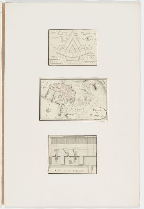
DR1974:0002:030:010:001-003
DR1974:0002:030:010:001-003
People:
Subject:
architecture, engineering, military, topographic
architecture, engineering, military, topographic
Date:
between 1800 and 1846
between 1800 and 1846
Title:
Partial plan and sections of fortifications; Map of Rhodes; Plan of a battery
Actions:
DR1974:0002:030:010:001-003
Partial plan and sections of fortifications; Map of Rhodes; Plan of a battery
Actions:
DR1974:0002:030:010:001-003
Form:
maps, works of art
maps, works of art
Date:
between 1800 and 1846
between 1800 and 1846
People:
Subject:
architecture, engineering, military, topographic
architecture, engineering, military, topographic
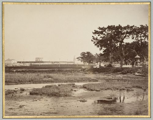
Form:
photographs
photographs

Title:
View of a lake showing a footpath, fortifications and a footbridge, Colombo, Ceylon (now Sri Lanka)
View of a lake showing a footpath, fortifications and a footbridge, Colombo, Ceylon (now Sri Lanka)
Actions:
Reference number:
PH1979:0447.04:071
PH1979:0447.04:071
People:
Subject:
architecture, military, topographic
architecture, military, topographic
Date:
between 1857 and 1896
between 1857 and 1896
Title:
View of a lake showing a footpath, fortifications and a footbridge, Colombo, Ceylon (now Sri Lanka)
Actions:
PH1979:0447.04:071
View of a lake showing a footpath, fortifications and a footbridge, Colombo, Ceylon (now Sri Lanka)
Actions:
PH1979:0447.04:071
Form:
photographs
photographs
Date:
between 1857 and 1896
between 1857 and 1896
People:
Subject:
architecture, military, topographic
architecture, military, topographic
Form:
photographs
photographs
Actions:
Reference number:
PH1981:0787:049
PH1981:0787:049
People:
Subject:
architecture, engineering, military, topographic
architecture, engineering, military, topographic
Date:
between 1863 and 1877
between 1863 and 1877
Title:
View of coastal fortifications showing a martello tower and a lighthouse, near Kobe, Japan
Actions:
PH1981:0787:049
View of coastal fortifications showing a martello tower and a lighthouse, near Kobe, Japan
Actions:
PH1981:0787:049
Form:
photographs
photographs
Date:
between 1863 and 1877
between 1863 and 1877
People:
Subject:
architecture, engineering, military, topographic
architecture, engineering, military, topographic
Form:
photographs
photographs
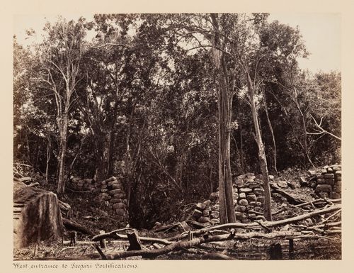
Actions:
Reference number:
PH1979:0447.04:043
PH1979:0447.04:043
People:
Subject:
architecture, military, topographic
architecture, military, topographic
Date:
between 1860 and 1872
between 1860 and 1872
Title:
View of the west entrance to the fortifications, Sigiriya, Ceylon (now Sri Lanka)
Actions:
PH1979:0447.04:043
View of the west entrance to the fortifications, Sigiriya, Ceylon (now Sri Lanka)
Actions:
PH1979:0447.04:043
Form:
photographs
photographs
Date:
between 1860 and 1872
between 1860 and 1872
People:
Subject:
architecture, military, topographic
architecture, military, topographic
Form:
photographs
photographs
Actions:
Reference number:
PH1980:0048.01:003
PH1980:0048.01:003
People:
Subject:
architecture, military
architecture, military
Date:
1859-1860
1859-1860
Title:
View of the ruins of the fortifications of Antioch, Ottoman Empire (now in Antakya, Turkey)
Actions:
PH1980:0048.01:003
View of the ruins of the fortifications of Antioch, Ottoman Empire (now in Antakya, Turkey)
Actions:
PH1980:0048.01:003
Form:
photographs
photographs
Date:
1859-1860
1859-1860
People:
Subject:
architecture, military
architecture, military
Form:
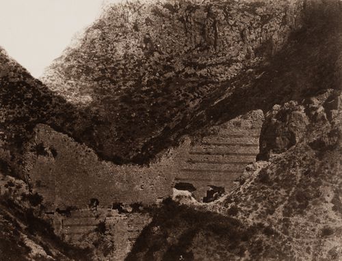
drawings
drawings
Actions:
Reference number:
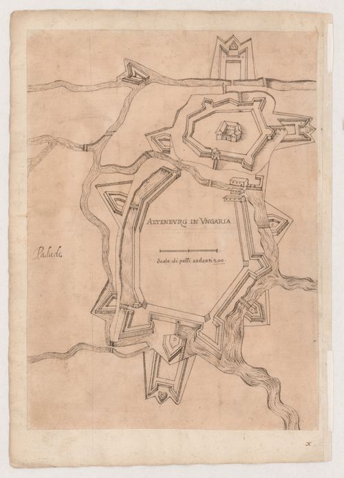
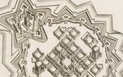
DR1981:0017:073 R/V
DR1981:0017:073 R/V
People:
Subject:
architecture
architecture
Date:
circa 1630-1640; verso: 1644
circa 1630-1640; verso: 1644
Title:
Schematic drawing of the fortifications at Altenberg, Hungary; verso: Map of the mouth of the Po River
Actions:
DR1981:0017:073 R/V
Schematic drawing of the fortifications at Altenberg, Hungary; verso: Map of the mouth of the Po River
Actions:
DR1981:0017:073 R/V
Form:
drawings
drawings
Date:
circa 1630-1640; verso: 1644
circa 1630-1640; verso: 1644
People:
Subject:
architecture
architecture
Form:
photographs
photographs

Actions:
Reference number:
PH1980:0393
PH1980:0393
People:
Subject:
architecture, topographic
architecture, topographic
Date:
1865
1865
Form:
photographs
photographs
Date:
1865
1865
People:
Subject:
architecture, topographic
architecture, topographic
Form:
photographs
photographs
![View of Kaiserburg [?] tower with portion of medieval city fortifications in foreground, Nuremberg [?], Germany](/img-collection/oQVPuxBBSiicILzP8jqPbHj7ib8=/500x666/4629.jpg)
Actions:
Reference number:
PH1981:1048
PH1981:1048
People:
Form:
photographs
photographs
People:
Form:
photographs
photographs

Actions:
Reference number:
PH1979:0447.04:044
PH1979:0447.04:044
People:
Subject:
architecture, topographic
architecture, topographic
Date:
between 1860 and 1872
between 1860 and 1872
Title:
View of the west façade of the fortifications showing retaining walls, Sigiriya, Ceylon (now Sri Lanka)
Actions:
PH1979:0447.04:044
View of the west façade of the fortifications showing retaining walls, Sigiriya, Ceylon (now Sri Lanka)
Actions:
PH1979:0447.04:044
Form:
photographs
photographs
Date:
between 1860 and 1872
between 1860 and 1872
People:
Subject:
architecture, topographic
architecture, topographic
Form:
photographs
photographs

Actions:
Reference number:
PH1980:0048.01:004
PH1980:0048.01:004
People:
Subject:
architecture, military
architecture, military
Date:
1859-1860
1859-1860
Title:
Distant view of the ruins of the fortifications of Antioch on Mount Silpius, Ottoman Empire (now in Antakya, Turkey)
Actions:
PH1980:0048.01:004
Distant view of the ruins of the fortifications of Antioch on Mount Silpius, Ottoman Empire (now in Antakya, Turkey)
Actions:
PH1980:0048.01:004
Form:
photographs
photographs
Date:
1859-1860
1859-1860
People:
Subject:
architecture, military
architecture, military
Form:
photographs
photographs

Actions:
Reference number:
PH1980:1229
PH1980:1229
People:
Subject:
architecture
architecture
Date:
ca. 1855
ca. 1855
Form:
photographs
photographs
Date:
ca. 1855
ca. 1855
People:
Subject:
architecture
architecture
Form:
photographs
photographs
![Distant view of the Khurshid Manzil [House of the Sun Palace] (now part of La Martinière College) showing fortifications in the foreground, Lucknow, India](/img-collection/YkBwRzNQOxlSGGi1vhQUu-0qR2E=/500x350/11901.jpg)
Actions:
Reference number:
PH1982:0301:023
PH1982:0301:023
People:
Subject:
architecture, military
architecture, military
Date:
1858
1858
Form:
photographs
photographs
Date:
1858
1858
People:
Subject:
architecture, military
architecture, military
Form:
photographs
photographs

Actions:
Reference number:
PH1980:0048.01:002
PH1980:0048.01:002
People:
Subject:
architecture, military
architecture, military
Date:
1859-1860
1859-1860
Form:
photographs
photographs
Date:
1859-1860
1859-1860
People:
Subject:
architecture, military
architecture, military
Form:
articles
articles
Actions:
Keyword(s):
17th century, 18th century, BLDGBLOG, feral city, fortifications, Geoff@CCA, Geoff Manaugh, Giacomo Fusto Castriotto, Girolamo Maggi, traités, treatises, ville sauvage, XVIe siècle, XVIIe siècle
17th century, 18th century, BLDGBLOG, feral city, fortifications, Geoff@CCA, Geoff Manaugh, Giacomo Fusto Castriotto, Girolamo Maggi, traités, treatises, ville sauvage, XVIe siècle, XVIIe siècle
Published:
22 June 2010
22 June 2010
Form:
events
events

Actions:
Keyword(s):
State, King , Seventeenth-century, French Architecture, Indra McEwen, Architecture of Fortification, Mechanical Body, Invisible Modern State, Visiting Scholar
State, King , Seventeenth-century, French Architecture, Indra McEwen, Architecture of Fortification, Mechanical Body, Invisible Modern State, Visiting Scholar
Date:
18 February 2000
18 February 2000
Form:
events
events
Date:
18 February 2000
18 February 2000
Form:
exhibitions
exhibitions

Actions:
Description:
*Opening the Gates of Eighteenth-Century Montréal* explores the development of the city during the eighteenth century, when Montréal was a fortified town. The exhibition provides a unique opportunity to consider the building of the eighteenth-century military and commercial town, the nucleus from which Montréal grew. The product of nearly fifteen years of research and(...)
*Opening the Gates of Eighteenth-Century Montréal* explores the development of the city during the eighteenth century, when Montréal was a fortified town. The exhibition provides a unique opportunity to consider the building of the eighteenth-century military and commercial town, the nucleus from which Montréal grew. The product of nearly fifteen years of research and(...)
Location:
Main galleries
Main galleries
Date:
8 September 1992 to 28 February 1993
8 September 1992 to 28 February 1993
Title:
Opening the Gates of Eighteenth-Century Montréal
Actions:
Description:
*Opening the Gates of Eighteenth-Century Montréal* explores the development of the city during the eighteenth century, when Montréal was a fortified town. The exhibition provides a unique opportunity to consider the building of the eighteenth-century military and commercial town, the nucleus from which Montréal grew. The product of nearly fifteen years of research and(...)
Form:
exhibitions
exhibitions
Date:
8 September 1992 to
28 February 1993
8 September 1992 to
28 February 1993
Location:
Main galleries
Main galleries
Form:
photographs
photographs

Actions:
Reference number:
PH1981:0669:002
PH1981:0669:002
People:
Date:
published 1856
published 1856
Title:
Plate from album ''Reuve Générale del Architecture et des Travaux Publics''
Actions:
PH1981:0669:002
Plate from album ''Reuve Générale del Architecture et des Travaux Publics''
Actions:
PH1981:0669:002
Form:
photographs
photographs
Date:
published 1856
published 1856
People:
Form:
works of art
works of art

Title:
Designs for fortified gates
Designs for fortified gates
Actions:
Reference number:
DR1981:0063
DR1981:0063
People:
Date:
printed 1784
printed 1784
Form:
works of art
works of art
Date:
printed 1784
printed 1784
People: