1488 Results
Form:
textual records
textual records
Title:
Washington Pass Center
Washington Pass Center
Actions:
Reference number:
ARCH271707
Description:
Group consists of documentation about the design of the Rest Facility Okanogan National Forest at Washington Pass, Washington, including documents entitled "Washington Pass Design Review" and "Design Criteria for Washington Pass Scenic Overlook and Visitor Center", and an interpretative design narrative by Douglas Kelbaugh. The group also includes correspondence and sketches.
People:
Date:
1990-1993
1990-1993
Title:
Washington Pass Center
Actions:
ARCH271707
Description:
Group consists of documentation about the design of the Rest Facility Okanogan National Forest at Washington Pass, Washington, including documents entitled "Washington Pass Design Review" and "Design Criteria for Washington Pass Scenic Overlook and Visitor Center", and an interpretative design narrative by Douglas Kelbaugh. The group also includes correspondence and sketches.
Form:
textual records
textual records
Date:
1990-1993
1990-1993
People:
Level of archival description:
Project
Project
Reference number:
AP075.S1.1969.PR01
Description:
Project series documents Cornelia Hahn Oberlander's landscape project for Acadia Park at the University of British Columbia, in Vancouver, British Columbia. Oberlander worked on this project in 1969. The project consisted in design the landscape master plan and the play area for the Acadia Married Student Housing complex, which included in kindergarten. Oberlander preserved the forest edge of the site and even included some of the mature trees present on the site by suspending rope swings to their trunks. The play area also reused ancient trees as play structures, and a wobble walk made of logs ends of various heights. The project series contains design development drawings, including a proposed landscape master plan and landscape plans, and also working drawings, such as elevations and details of the playground structures and benches. The project is also documented through photographs of the playground and correspondence with clients. Source: [1] Herrington, Susan. Cornelia Hahn Oberlander: Making the Modern Landscape, University of Virginia Press, 2014, 304 pages.
People:
Date:
1966-1971
1966-1971
Title:
Acadia Park, University of British Columbia, Vancouver, British Columbia (1969)
Actions:
AP075.S1.1969.PR01
Description:
Project series documents Cornelia Hahn Oberlander's landscape project for Acadia Park at the University of British Columbia, in Vancouver, British Columbia. Oberlander worked on this project in 1969. The project consisted in design the landscape master plan and the play area for the Acadia Married Student Housing complex, which included in kindergarten. Oberlander preserved the forest edge of the site and even included some of the mature trees present on the site by suspending rope swings to their trunks. The play area also reused ancient trees as play structures, and a wobble walk made of logs ends of various heights. The project series contains design development drawings, including a proposed landscape master plan and landscape plans, and also working drawings, such as elevations and details of the playground structures and benches. The project is also documented through photographs of the playground and correspondence with clients. Source: [1] Herrington, Susan. Cornelia Hahn Oberlander: Making the Modern Landscape, University of Virginia Press, 2014, 304 pages.
Level of archival description:
Project
Project
Date:
1966-1971
1966-1971
People:
Level of archival description:
Series
Series
Title:
Olzweg
Olzweg
Actions:
Reference number:
AP193.S3
Description:
Series 3, Olzweg, 2006, relates to a competition proposal conceptualized in 2006 for an extension to the Fond Régional d’Art Contemporain (FRAC) in Orléans, France. The records contain images of plans, elevations, sections, and renderings of the project and the robot. There are also pictures of the model and an animated rendering of different 3D model views. The FRAC competition sought an emblematic extension that would complement the original 18th century building hosting the collection. R&Sie(n)’s project earned second place in the competition. The project takes its name from Holzwege a book from Heidegger inspired by the paths that winds through the forest. It consists of a labyrinth of recycled glass sticks, which appeared to be “glued” to the existing building and courtyard. The glass comes from recycled bottles provided by the neighborhood inhabitants. R&Sie(n) sees this as a form of criticism of France’s relation to wine consumption through its materialization. The labyrinth is progressively constructed and rearranged by a robotic arm and randomized, interactive software continuously reprogramming its parameters during construction.
People:
Date:
2006
2006
Title:
Olzweg
Actions:
AP193.S3
Description:
Series 3, Olzweg, 2006, relates to a competition proposal conceptualized in 2006 for an extension to the Fond Régional d’Art Contemporain (FRAC) in Orléans, France. The records contain images of plans, elevations, sections, and renderings of the project and the robot. There are also pictures of the model and an animated rendering of different 3D model views. The FRAC competition sought an emblematic extension that would complement the original 18th century building hosting the collection. R&Sie(n)’s project earned second place in the competition. The project takes its name from Holzwege a book from Heidegger inspired by the paths that winds through the forest. It consists of a labyrinth of recycled glass sticks, which appeared to be “glued” to the existing building and courtyard. The glass comes from recycled bottles provided by the neighborhood inhabitants. R&Sie(n) sees this as a form of criticism of France’s relation to wine consumption through its materialization. The labyrinth is progressively constructed and rearranged by a robotic arm and randomized, interactive software continuously reprogramming its parameters during construction.
Level of archival description:
Series
Series
Date:
2006
2006
People:
Level of archival description:
Sub-series
Sub-series
Title:
Student work
Student work
Reference number:
AP140.S1.SS1
Description:
Sub-series documents James Stirling's student work, probably from his third to fifth year at the Liverpool School of Architecture in Liverpool, England, from 1947 to 1950, and during his studies at the Association for Planning and Regional Reconstruction in London, England, from 1950 to 1952. A project for a Community Centre for a Small Town in the Middle West was probably produced during a student exchange in New York City, New York in the fall of 1948. Sub-series include projects for a Forest Rangers Lookout Station, a House for an Architect, Organic Chemistry Laboratories, Stirling's thesis project for a Town Centre and Community Centre and a student competition entry for the Merseyside Film Institute. Material in this sub-series was probably produced between 1947 and 1975. The publication drawings for James Stirling's projects were often drawn by Leon Krier, Russell Bevington, or Ulrich Schaad ('British Architecture Today', 1991). Sub-series contains several presentation drawings and panels, publication drawings, a small number of working drawings, photographic materials, a presentation model and Stirling's 1950 bound thesis 'Plan of Town Centre and Development of Community Centre for Newton Aycliffe, Co. Durham'.
People:
Date:
[between 1947? and 1975?], predominant 1947-1952
[between 1947? and 1975?], predominant 1947-1952
Title:
Student work
Actions:
AP140.S1.SS1
Description:
Sub-series documents James Stirling's student work, probably from his third to fifth year at the Liverpool School of Architecture in Liverpool, England, from 1947 to 1950, and during his studies at the Association for Planning and Regional Reconstruction in London, England, from 1950 to 1952. A project for a Community Centre for a Small Town in the Middle West was probably produced during a student exchange in New York City, New York in the fall of 1948. Sub-series include projects for a Forest Rangers Lookout Station, a House for an Architect, Organic Chemistry Laboratories, Stirling's thesis project for a Town Centre and Community Centre and a student competition entry for the Merseyside Film Institute. Material in this sub-series was probably produced between 1947 and 1975. The publication drawings for James Stirling's projects were often drawn by Leon Krier, Russell Bevington, or Ulrich Schaad ('British Architecture Today', 1991). Sub-series contains several presentation drawings and panels, publication drawings, a small number of working drawings, photographic materials, a presentation model and Stirling's 1950 bound thesis 'Plan of Town Centre and Development of Community Centre for Newton Aycliffe, Co. Durham'.
Level of archival description:
Sub-series 1
Sub-series 1
Date:
[between 1947? and 1975?], predominant 1947-1952
[between 1947? and 1975?], predominant 1947-1952
People:
Level of archival description:
Project
Project
Actions:
Reference number:
AP075.S1.1979.PR04
Description:
Project series documents Cornelia Hahn Oberlander's landscape project for the British Columbia Institute of Technology (B.C.I.T.) site at the Discovery Parks Multi Tenant Facility, located on Willingdon Avenue, in Burnaby, British Columbia. Created in 1979, Discovery Parks is an organization with the mission to accomodate scientific and technological research activities by building and renting research installations. Initially founded by the provincial government, Discovery Parks became self-governning and independant in 1990. Oberlander worked on the Discovery Parks B.C.I.T's site from 1979-1984 with Russell Vandiver Architects. The concept of B.C.I.T's site was to create a park like environment for an industrial research site. The site was surrounded by a woodland and included a wetland. To reflect the existing condition of her landscape design, Oberlander added a rentention pool and a restored woodland, creating a urban forest using native plants. The project was completed in 1982. The project series contains textual documents, such as correspondence with client and architects, financial documents, minutes of meetings, specifications and Oberlander's concept notes. The project is also documented through working drawings, including grading plans, irrigation plans, landscape plans and sites plans. It also included reference drawings of the site, photographs of the completed landscape and a mounted photographs of the a section of the landscape design by Oberlander.
People:
Date:
1979-1990
1979-1990
Title:
British Columbia Institute of Technology Multi Tenant Facility, Discovery Parks, Willingdon Site, Burnaby, British Columbia (1987-1984)
Actions:
AP075.S1.1979.PR04
Description:
Project series documents Cornelia Hahn Oberlander's landscape project for the British Columbia Institute of Technology (B.C.I.T.) site at the Discovery Parks Multi Tenant Facility, located on Willingdon Avenue, in Burnaby, British Columbia. Created in 1979, Discovery Parks is an organization with the mission to accomodate scientific and technological research activities by building and renting research installations. Initially founded by the provincial government, Discovery Parks became self-governning and independant in 1990. Oberlander worked on the Discovery Parks B.C.I.T's site from 1979-1984 with Russell Vandiver Architects. The concept of B.C.I.T's site was to create a park like environment for an industrial research site. The site was surrounded by a woodland and included a wetland. To reflect the existing condition of her landscape design, Oberlander added a rentention pool and a restored woodland, creating a urban forest using native plants. The project was completed in 1982. The project series contains textual documents, such as correspondence with client and architects, financial documents, minutes of meetings, specifications and Oberlander's concept notes. The project is also documented through working drawings, including grading plans, irrigation plans, landscape plans and sites plans. It also included reference drawings of the site, photographs of the completed landscape and a mounted photographs of the a section of the landscape design by Oberlander.
Level of archival description:
Project
Project
Date:
1979-1990
1979-1990
People:
Level of archival description:
Project
Project
Reference number:
AP075.S1.1995.PR01
Description:
Project series documents Cornelia Hahn Oberlander's project for proposed improvements to the garden of the Rotman Residence on Forest Hill Road in Toronto, Ontario. Orberlander worked on this project in 1994. The Georgian style residence was originally design by architect John Lyle in 1924. As the residence was sited perpendicularly to the street, Oberlander's landscape concept was to create a series of garden from the street to the back of the property, which included terraces for entertaining at the front of the property, a rose garden and lawn for strolling. She also created a birch trees walk with ascending grass stairs. Oberlander was later commissioned in 1996-1997 to combine the existing garden with an extensionof the property after the acquisition of a lot next door by the owners of the residence. She extended the birch walk and created a oval-shaped lawn accessed through a wrought iron gate. The project series also contains material related to later restorations to the garden, including an alteration to the garden in 2013 to improve the view from the living room. The project series contains design development drawings, including landscape plans, planting plans, and grading plans, and also a landscape presentation drawing.The project is also documents through photographs of the landscaping, research material, correspondence with clients and contractors, concept notes by Oberlander, specifications, and meetings notes.
People:
Date:
1994-2014
1994-2014
Title:
Rotman Residence, Toronto, Ontario (1995-1997)
Actions:
AP075.S1.1995.PR01
Description:
Project series documents Cornelia Hahn Oberlander's project for proposed improvements to the garden of the Rotman Residence on Forest Hill Road in Toronto, Ontario. Orberlander worked on this project in 1994. The Georgian style residence was originally design by architect John Lyle in 1924. As the residence was sited perpendicularly to the street, Oberlander's landscape concept was to create a series of garden from the street to the back of the property, which included terraces for entertaining at the front of the property, a rose garden and lawn for strolling. She also created a birch trees walk with ascending grass stairs. Oberlander was later commissioned in 1996-1997 to combine the existing garden with an extensionof the property after the acquisition of a lot next door by the owners of the residence. She extended the birch walk and created a oval-shaped lawn accessed through a wrought iron gate. The project series also contains material related to later restorations to the garden, including an alteration to the garden in 2013 to improve the view from the living room. The project series contains design development drawings, including landscape plans, planting plans, and grading plans, and also a landscape presentation drawing.The project is also documents through photographs of the landscaping, research material, correspondence with clients and contractors, concept notes by Oberlander, specifications, and meetings notes.
Level of archival description:
Project
Project
Date:
1994-2014
1994-2014
People:
Form:
drawings
drawings
Actions:
Reference number:
DR1987:0061
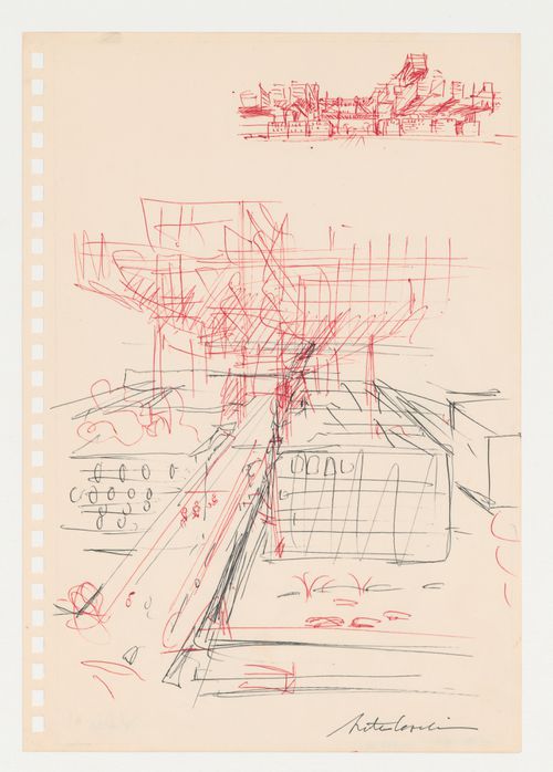
Description:
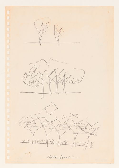
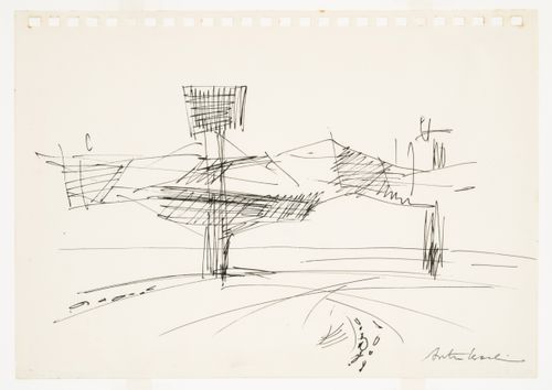
- This drawing is one of four drawings by Arata Isozaki for the "City in the Air" schemes of 1960-1963. Three of these drawings are studies for the "Clusters in the Air" project of 1960-1962: a sketch showing a general view of the project, DR1987:0117, a more finished version of the same view, DR1987:0062, and a three-stage sketch showing trees becoming a forest, DR1987:0116. The sketch of trees demonstrates the principal idea behind the "Clusters in the Air" project; enormous supports (trunks) support passageways (branches) to which living units (leaves) are gradually added. The trees develope side by side, with branches of different trees joining up, creating a "forest" (Isozaki 1992, 20-23, 29). The subject of this drawing is unclear although it is possibly a conceptual drawing for the Marunouchi Project of 1963, a proposal for a "City in the Air" in the central business district of Tokyo (Isozaki 1992, 27, 29). All four drawings are executed on sheets perforated with square holes for insertion into a spiral notebook.
DR1987:0061
Description:
- This drawing is one of four drawings by Arata Isozaki for the "City in the Air" schemes of 1960-1963. Three of these drawings are studies for the "Clusters in the Air" project of 1960-1962: a sketch showing a general view of the project, DR1987:0117, a more finished version of the same view, DR1987:0062, and a three-stage sketch showing trees becoming a forest, DR1987:0116. The sketch of trees demonstrates the principal idea behind the "Clusters in the Air" project; enormous supports (trunks) support passageways (branches) to which living units (leaves) are gradually added. The trees develope side by side, with branches of different trees joining up, creating a "forest" (Isozaki 1992, 20-23, 29). The subject of this drawing is unclear although it is possibly a conceptual drawing for the Marunouchi Project of 1963, a proposal for a "City in the Air" in the central business district of Tokyo (Isozaki 1992, 27, 29). All four drawings are executed on sheets perforated with square holes for insertion into a spiral notebook.
People:
Subject:
architecture
architecture
Date:
ca. 1960-1963
ca. 1960-1963
Title:
Sketch for an urban structure raised on pylons, possibly for the Marunouchi Project, Tokyo
Actions:
DR1987:0061
Description:
- This drawing is one of four drawings by Arata Isozaki for the "City in the Air" schemes of 1960-1963. Three of these drawings are studies for the "Clusters in the Air" project of 1960-1962: a sketch showing a general view of the project, DR1987:0117, a more finished version of the same view, DR1987:0062, and a three-stage sketch showing trees becoming a forest, DR1987:0116. The sketch of trees demonstrates the principal idea behind the "Clusters in the Air" project; enormous supports (trunks) support passageways (branches) to which living units (leaves) are gradually added. The trees develope side by side, with branches of different trees joining up, creating a "forest" (Isozaki 1992, 20-23, 29). The subject of this drawing is unclear although it is possibly a conceptual drawing for the Marunouchi Project of 1963, a proposal for a "City in the Air" in the central business district of Tokyo (Isozaki 1992, 27, 29). All four drawings are executed on sheets perforated with square holes for insertion into a spiral notebook.
Form:
drawings
drawings
Date:
ca. 1960-1963
ca. 1960-1963
People:
Subject:
architecture
architecture
Form:
drawings
drawings

Actions:
Reference number:
DR1987:0062
Description:
General view - This drawing is one of four drawings by Arata Isozaki for the "City in the Air" schemes of 1960-1963. Three of these drawings are studies for the "Clusters in the Air" project of 1960-1962: a sketch showing a general view of the project, DR1987:0117, a more finished version of the same view, DR1987:0062, and a three-stage sketch showing trees becoming a forest, DR1987:0116. The sketch of trees demonstrates the principal idea behind the "Clusters in the Air" project; enormous supports (trunks) support passageways (branches) to which living units (leaves) are gradually added. The trees develope side by side, with branches of different trees joining up, creating a "forest" (Isozaki 1992, 20-23, 29). the subject of the fourth drawing, DR1987:0061, is unclear although it is possibly a conceptual drawing for the Marunouchi Project of 1963, a proposal for a "City in the Air" in the central business district of Tokyo (Isozaki 1992, 27, 29). All four drawings are executed on sheets perforated with square holes for insertion into a spiral notebook.
People:
Subject:
architecture
architecture
Date:
between 1960-1962
between 1960-1962
Title:
Sketch for the Clusters in the Air Project, Tokyo
Actions:
DR1987:0062
Description:
General view - This drawing is one of four drawings by Arata Isozaki for the "City in the Air" schemes of 1960-1963. Three of these drawings are studies for the "Clusters in the Air" project of 1960-1962: a sketch showing a general view of the project, DR1987:0117, a more finished version of the same view, DR1987:0062, and a three-stage sketch showing trees becoming a forest, DR1987:0116. The sketch of trees demonstrates the principal idea behind the "Clusters in the Air" project; enormous supports (trunks) support passageways (branches) to which living units (leaves) are gradually added. The trees develope side by side, with branches of different trees joining up, creating a "forest" (Isozaki 1992, 20-23, 29). the subject of the fourth drawing, DR1987:0061, is unclear although it is possibly a conceptual drawing for the Marunouchi Project of 1963, a proposal for a "City in the Air" in the central business district of Tokyo (Isozaki 1992, 27, 29). All four drawings are executed on sheets perforated with square holes for insertion into a spiral notebook.
Form:
drawings
drawings
Date:
between 1960-1962
between 1960-1962
People:
Subject:
architecture
architecture
Form:
drawings
drawings
Actions:
Reference number:
DR1987:0116
Description:
- This drawing is one of four drawings by Arata Isozaki for the "City in the Air" schemes of 1960-1963. Three of these drawings are studies for the "Clusters in the Air" project of 1960-1962: a sketch showing a general view of the project, DR1987:0117, a more finished version of the same view, DR1987:0062, and a three-stage sketch showing trees becoming a forest, DR1987:0116. The sketch of trees demonstrates the principal idea behind the "Clusters in the Air" project; enormous supports (trunks) support passageways (branches) to which living units (leaves) are gradually added. The trees develope side by side, with branches of different trees joining up, creating a "forest" (Isozaki 1992, 20-23, 29). The subject of the fourth drawing, DR1987:0061, is unclear although it is possibly a conceptual drawing for the Marunouchi Project of 1963, a proposal for a "City in the Air" in the central business district of Tokyo (Isozaki 1992, 27, 29). All four drawings are executed on sheets perforated with square holes for insertion into a spiral notebook.
People:
Subject:
architecture
architecture
Date:
between 1960-1962
between 1960-1962
Title:
Sketch of a grouping of trees for the Clusters in the Air Project, Tokyo
Actions:
DR1987:0116
Description:
- This drawing is one of four drawings by Arata Isozaki for the "City in the Air" schemes of 1960-1963. Three of these drawings are studies for the "Clusters in the Air" project of 1960-1962: a sketch showing a general view of the project, DR1987:0117, a more finished version of the same view, DR1987:0062, and a three-stage sketch showing trees becoming a forest, DR1987:0116. The sketch of trees demonstrates the principal idea behind the "Clusters in the Air" project; enormous supports (trunks) support passageways (branches) to which living units (leaves) are gradually added. The trees develope side by side, with branches of different trees joining up, creating a "forest" (Isozaki 1992, 20-23, 29). The subject of the fourth drawing, DR1987:0061, is unclear although it is possibly a conceptual drawing for the Marunouchi Project of 1963, a proposal for a "City in the Air" in the central business district of Tokyo (Isozaki 1992, 27, 29). All four drawings are executed on sheets perforated with square holes for insertion into a spiral notebook.
Form:
drawings
drawings
Date:
between 1960-1962
between 1960-1962
People:
Subject:
architecture
architecture
Form:
drawings
drawings
Reference number:
DR1987:0117
Description:
- This drawing is one of four drawings by Arata Isozaki for the "City in the Air" schemes of 1960-1963. Three of these drawings are studies for the "Clusters in the Air" project of 1960-1962: a sketch showing a general view of the project, DR1987:0117, a more finished version of the same view, DR1987:0062, and a three-stage sketch showing trees becoming a forest, DR1987:0116. The sketch of trees demonstrates the principal idea behind the "Clusters in the Air" project; enormous supports (trunks) support passageways (branches) to which living units (leaves) are gradually added. The trees develope side by side, with branches of different trees joining up, creating a "forest" (Isozaki 1992, 20-23, 29). The subject of the fourth drawing, DR1987:0061, is unclear although it is possibly a conceptual drawing for the Marunouchi Project of 1963, a proposal for a "City in the Air" in the central business district of Tokyo (Isozaki 1992, 27, 29). All four drawings are executed on sheets perforated with square holes for insertion into a spiral notebook.
People:
Subject:
architecture
architecture
Date:
between 1960-1962
between 1960-1962
Title:
Sketch for the Clusters in the Air Project, Tokyo: General view
Actions:
DR1987:0117
Description:
- This drawing is one of four drawings by Arata Isozaki for the "City in the Air" schemes of 1960-1963. Three of these drawings are studies for the "Clusters in the Air" project of 1960-1962: a sketch showing a general view of the project, DR1987:0117, a more finished version of the same view, DR1987:0062, and a three-stage sketch showing trees becoming a forest, DR1987:0116. The sketch of trees demonstrates the principal idea behind the "Clusters in the Air" project; enormous supports (trunks) support passageways (branches) to which living units (leaves) are gradually added. The trees develope side by side, with branches of different trees joining up, creating a "forest" (Isozaki 1992, 20-23, 29). The subject of the fourth drawing, DR1987:0061, is unclear although it is possibly a conceptual drawing for the Marunouchi Project of 1963, a proposal for a "City in the Air" in the central business district of Tokyo (Isozaki 1992, 27, 29). All four drawings are executed on sheets perforated with square holes for insertion into a spiral notebook.
Form:
drawings
drawings
Date:
between 1960-1962
between 1960-1962
People:
Subject:
architecture
architecture