9487 Results
Form:
photographs
photographs
Reference number:
PH1980:0211:129
PH1980:0211:129
People:
Date:
24 September - 10 November 1904
24 September - 10 November 1904
Form:
photographs
photographs
Date:
24 September - 10 November 1904
24 September - 10 November 1904
People:
Form:
drawings
drawings
Actions:
Reference number:
AP046.S1.1983.PR01.524
Description:
This file includes hand coloured presentation drawings for the main entrance, proposed CCA garden Baile Park and vehicle entrance.
AP046.S1.1983.PR01.524
Description:
This file includes hand coloured presentation drawings for the main entrance, proposed CCA garden Baile Park and vehicle entrance.
People:
Date:
ca 1983
ca 1983
Title:
Colour presentation drawings for Baile Park and CCA garden, Canadian Centre for Architecture, Montréal, Québec
Actions:
AP046.S1.1983.PR01.524
Description:
This file includes hand coloured presentation drawings for the main entrance, proposed CCA garden Baile Park and vehicle entrance.
Colour presentation drawings for Baile Park and CCA garden, Canadian Centre for Architecture, Montréal, Québec
Actions:
AP046.S1.1983.PR01.524
Description:
This file includes hand coloured presentation drawings for the main entrance, proposed CCA garden Baile Park and vehicle entrance.
Form:
drawings
drawings
Date:
ca 1983
ca 1983
People:
Form:
drawings
drawings
Reference number:
DR1983:0576
Description:
- This design is for a classical garden pavilion described in plan, section, and elevation. Set on an octagonal plan, the pavilion is comprised of eight columns supporting a segmented dome made of wood and carrying a concave conical lantern.
DR1983:0576
Description:
- This design is for a classical garden pavilion described in plan, section, and elevation. Set on an octagonal plan, the pavilion is comprised of eight columns supporting a segmented dome made of wood and carrying a concave conical lantern.
People:
Subject:
architecture, landscape architecture
architecture, landscape architecture
Date:
1862
1862
Title:
Garden Temple for H. R. Hughes Esq: / Kimnel [sic] Park:
Actions:
DR1983:0576
Description:
- This design is for a classical garden pavilion described in plan, section, and elevation. Set on an octagonal plan, the pavilion is comprised of eight columns supporting a segmented dome made of wood and carrying a concave conical lantern.
Form:
drawings
drawings
Date:
1862
1862
People:
Subject:
architecture, landscape architecture
architecture, landscape architecture
Form:
drawings
drawings
Reference number:
DR1983:0585
DR1983:0585
People:
Date:
1858-1895
1858-1895
Form:
drawings
drawings
Date:
1858-1895
1858-1895
People:
Form:
photographs
photographs
Reference number:
PH1988:0253
PH1988:0253
People:
Subject:
architecture, landscape architecture
architecture, landscape architecture
Date:
1985
1985
Form:
photographs
photographs
Date:
1985
1985
People:
Subject:
architecture, landscape architecture
architecture, landscape architecture
Form:
photographs
photographs
Reference number:
PH1988:0259
PH1988:0259
People:
Subject:
architecture, landscape architecture
architecture, landscape architecture
Date:
1987
1987
Form:
photographs
photographs
Date:
1987
1987
People:
Subject:
architecture, landscape architecture
architecture, landscape architecture
Level of archival description:
Project
Project
Actions:
Reference number:
AP178.S1.1985.PR01
Description:
This project series documents the Van der Vennepark, Schilderswijk-west in The Hague, The Netherlands. While the records were held in the office’s archives this project was assigned the number 32/80. The office assigned the date 1985 to this project. This small park was designed in connection to the housing and shopping complex in Schilderswijk (see project series AP178.S1.1984.PR03 in this fonds) as part of an urban renewal program in The Hague. Siza also designed the urban plan for Deelgebied Zone 5, Schilderswijk-West and the Punt en Komma social housing for the same urban renewal program. He would later design the residential settlement in Schilderswijk [Plano de Doedijnstraat]. The project was not realized. The project series contains a small amount of material. Documenting the park are plans and details, including reprographic copies, for seating arrangements, ramps, a pedestrian exit, as well as reprographic copies showing the housing and shopping complex in relation to the park. Also included is a written description of the project. This project series also contains information related to the housing and shopping complex.
People:
Date:
1983-1988
1983-1988
Title:
Jardim Van der Vennepark [Park, Schilderswijk-West], The Hague, The Netherlands (1985-1988)
Actions:
AP178.S1.1985.PR01
Description:
This project series documents the Van der Vennepark, Schilderswijk-west in The Hague, The Netherlands. While the records were held in the office’s archives this project was assigned the number 32/80. The office assigned the date 1985 to this project. This small park was designed in connection to the housing and shopping complex in Schilderswijk (see project series AP178.S1.1984.PR03 in this fonds) as part of an urban renewal program in The Hague. Siza also designed the urban plan for Deelgebied Zone 5, Schilderswijk-West and the Punt en Komma social housing for the same urban renewal program. He would later design the residential settlement in Schilderswijk [Plano de Doedijnstraat]. The project was not realized. The project series contains a small amount of material. Documenting the park are plans and details, including reprographic copies, for seating arrangements, ramps, a pedestrian exit, as well as reprographic copies showing the housing and shopping complex in relation to the park. Also included is a written description of the project. This project series also contains information related to the housing and shopping complex.
Level of archival description:
Project
Project
Date:
1983-1988
1983-1988
People:
Form:
drawings
drawings
Actions:
Reference number:
DR1985:0415
Description:
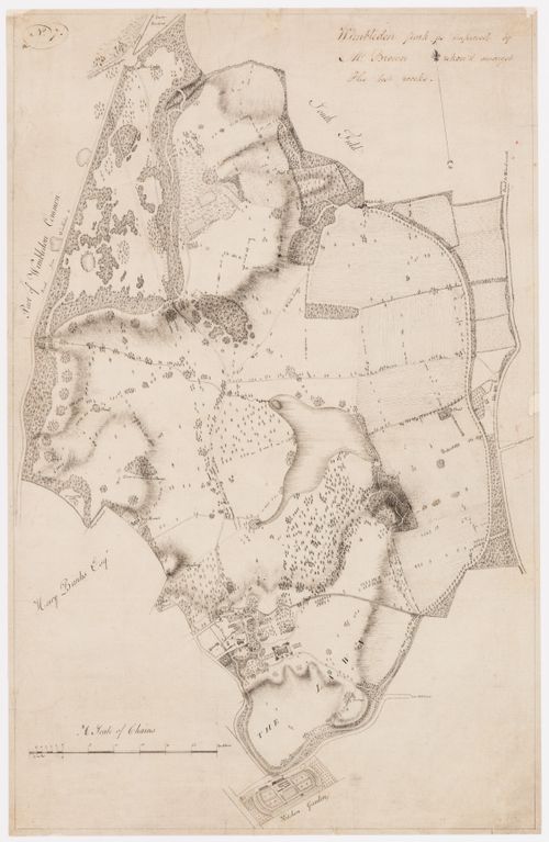
- DR1985:0415 presents a cartographic survey of Wimbledon Park as "improved" in the second half of the eighteenth century. Covering some 1,200 acres, the park as shown in this plan contains all the elements of Capability Brown's mature landscape style: expanses of grass traversed by meandering paths, irregular plantings of trees placed singly and in clumps, and winding streams dammed to create a large, irregular lake near the centre of the property and several small ponds about the periphery. The main house (built 1732-33 for Sarah, the Duchess of Marlborough), its outbuildings, and the village church are shown at the southern end of the park, as is a kitchen garden dating from an earlier period. Roads, lanes, and neighbouring properties are neatly labelled in the draughtsman's hand, and the fall of the land has been indicated in shade lines.
DR1985:0415
Description:
- DR1985:0415 presents a cartographic survey of Wimbledon Park as "improved" in the second half of the eighteenth century. Covering some 1,200 acres, the park as shown in this plan contains all the elements of Capability Brown's mature landscape style: expanses of grass traversed by meandering paths, irregular plantings of trees placed singly and in clumps, and winding streams dammed to create a large, irregular lake near the centre of the property and several small ponds about the periphery. The main house (built 1732-33 for Sarah, the Duchess of Marlborough), its outbuildings, and the village church are shown at the southern end of the park, as is a kitchen garden dating from an earlier period. Roads, lanes, and neighbouring properties are neatly labelled in the draughtsman's hand, and the fall of the land has been indicated in shade lines.
People:
Subject:
landscape architecture, topographic
landscape architecture, topographic
Date:
between 1765 and 1785
between 1765 and 1785
Title:
A survey plan of Wimbledon Park as designed for Lord Spencer by Capability Brown
Actions:
DR1985:0415
Description:
- DR1985:0415 presents a cartographic survey of Wimbledon Park as "improved" in the second half of the eighteenth century. Covering some 1,200 acres, the park as shown in this plan contains all the elements of Capability Brown's mature landscape style: expanses of grass traversed by meandering paths, irregular plantings of trees placed singly and in clumps, and winding streams dammed to create a large, irregular lake near the centre of the property and several small ponds about the periphery. The main house (built 1732-33 for Sarah, the Duchess of Marlborough), its outbuildings, and the village church are shown at the southern end of the park, as is a kitchen garden dating from an earlier period. Roads, lanes, and neighbouring properties are neatly labelled in the draughtsman's hand, and the fall of the land has been indicated in shade lines.
Form:
drawings
drawings
Date:
between 1765 and 1785
between 1765 and 1785
People:
Subject:
landscape architecture, topographic
landscape architecture, topographic
Form:
photographs
photographs

Actions:
Reference number:
PH1992:0159
PH1992:0159
People:
Date:
May 1991
May 1991
Title:
Viewing Olmsted: View of Genesee River, Seneca Park, Rochester, New York
Actions:
PH1992:0159
Viewing Olmsted: View of Genesee River, Seneca Park, Rochester, New York
Actions:
PH1992:0159
Form:
photographs
photographs
Date:
May 1991
May 1991
People:
Form:
photographs
photographs

Actions:
Reference number:
PH1992:0163
PH1992:0163
People:
Date:
May 1991
May 1991
Title:
Viewing Olmsted: View of Country meadow, Delaware Park, Buffalo, New York
Actions:
PH1992:0163
Viewing Olmsted: View of Country meadow, Delaware Park, Buffalo, New York
Actions:
PH1992:0163
Form:
photographs
photographs
Date:
May 1991
May 1991
People: