7174 Results
Form:
drawings
drawings
Title:
Site, garage, planting and floor plans, Office Building, 1500 Don Mills Road, North York, Ontario
Site, garage, planting and floor plans, Office Building, 1500 Don Mills Road, North York, Ontario
Actions:
Reference number:
AP018.S1.1976.PR19.014
AP018.S1.1976.PR19.014
People:
Date:
1978-1979
1978-1979
Title:
Site, garage, planting and floor plans, Office Building, 1500 Don Mills Road, North York, Ontario
Actions:
AP018.S1.1976.PR19.014
Site, garage, planting and floor plans, Office Building, 1500 Don Mills Road, North York, Ontario
Actions:
AP018.S1.1976.PR19.014
Form:
drawings
drawings
Date:
1978-1979
1978-1979
People:
Form:
drawings
drawings
Title:
Short and long span parking studies, Parking Structure, 1500 Don Mills Road, North York, Ontario
Short and long span parking studies, Parking Structure, 1500 Don Mills Road, North York, Ontario
Actions:
Reference number:
AP018.S1.1980.PR01.001
AP018.S1.1980.PR01.001
People:
Date:
circa 1980
circa 1980
Title:
Short and long span parking studies, Parking Structure, 1500 Don Mills Road, North York, Ontario
Actions:
AP018.S1.1980.PR01.001
Short and long span parking studies, Parking Structure, 1500 Don Mills Road, North York, Ontario
Actions:
AP018.S1.1980.PR01.001
Form:
drawings
drawings
Date:
circa 1980
circa 1980
People:
Form:
drawings, textual records
drawings, textual records
Actions:
Reference number:
AP018.S1.1980.PR01.004
AP018.S1.1980.PR01.004
People:
Date:
1980-1981
1980-1981
Title:
Project proposal, conference report and correspondence, Parking Structure, 1500 Don Mills Road, North York, Ontario
Actions:
AP018.S1.1980.PR01.004
Project proposal, conference report and correspondence, Parking Structure, 1500 Don Mills Road, North York, Ontario
Actions:
AP018.S1.1980.PR01.004
Form:
drawings, textual records
drawings, textual records
Date:
1980-1981
1980-1981
People:
Form:
photographs
photographs
Actions:
Reference number:
PH1986:0901:015:002
Description:
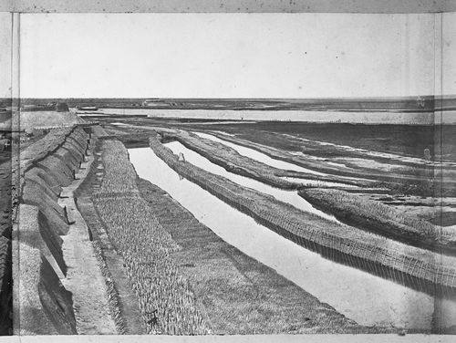
- This photograph is one in a series of views which Felice Beato made of the four Taku Forts (Harris, p. 139; Worswick, p. 138). - This photograph was made from the Great South Taku Fort looking north across the walls of the fort and the Pei (now Hai) River toward the Gulf of Chihli (now Bo Hai) (Harris, p. 143). - A copy print of this panorama under the title "Interior of South Taku Fort and Showing the Place of Landing June 25th 1859" is reproduced in Harris on pages 68-69 (cat. no. 23), and a copy print of PH1986:0901:015:002 (p. 167, fig. 23-3) under the title "Pei-Ho River and Taku Fort II" is reproduced in Harris on p. 167 (fig. 23-3).
PH1986:0901:015:002
Description:
- This photograph is one in a series of views which Felice Beato made of the four Taku Forts (Harris, p. 139; Worswick, p. 138). - This photograph was made from the Great South Taku Fort looking north across the walls of the fort and the Pei (now Hai) River toward the Gulf of Chihli (now Bo Hai) (Harris, p. 143). - A copy print of this panorama under the title "Interior of South Taku Fort and Showing the Place of Landing June 25th 1859" is reproduced in Harris on pages 68-69 (cat. no. 23), and a copy print of PH1986:0901:015:002 (p. 167, fig. 23-3) under the title "Pei-Ho River and Taku Fort II" is reproduced in Harris on p. 167 (fig. 23-3).
People:
Subject:
architecture, engineering, military, topographic
architecture, engineering, military, topographic
Date:
between 22 August and 21 September 1860
between 22 August and 21 September 1860
Title:
View showing part of the Great South Taku Fort and the Pei (now Hai) River delta, with the Lower North Taku Fort (also known as the 2nd North Fort) in the background, Taku (now Dagu), near Tientsin (now Tianjin), China
Actions:
PH1986:0901:015:002
Description:
- This photograph is one in a series of views which Felice Beato made of the four Taku Forts (Harris, p. 139; Worswick, p. 138). - This photograph was made from the Great South Taku Fort looking north across the walls of the fort and the Pei (now Hai) River toward the Gulf of Chihli (now Bo Hai) (Harris, p. 143). - A copy print of this panorama under the title "Interior of South Taku Fort and Showing the Place of Landing June 25th 1859" is reproduced in Harris on pages 68-69 (cat. no. 23), and a copy print of PH1986:0901:015:002 (p. 167, fig. 23-3) under the title "Pei-Ho River and Taku Fort II" is reproduced in Harris on p. 167 (fig. 23-3).
Form:
photographs
photographs
Date:
between 22 August and 21 September 1860
between 22 August and 21 September 1860
People:
Subject:
architecture, engineering, military, topographic
architecture, engineering, military, topographic
Form:
drawings
drawings
Actions:
Reference number:
AP018.S1.1959.PR01.002
AP018.S1.1959.PR01.002
People:
Date:
circa 1959
circa 1959
Title:
Landscape plans and elevation, Residence of Mr. & Mrs. J.C. Parkin, Alterations and Additions, North York, Ontario
Actions:
AP018.S1.1959.PR01.002
Landscape plans and elevation, Residence of Mr. & Mrs. J.C. Parkin, Alterations and Additions, North York, Ontario
Actions:
AP018.S1.1959.PR01.002
Form:
drawings
drawings
Date:
circa 1959
circa 1959
People:
Form:
drawings
drawings
Actions:
Reference number:
AP018.S1.1959.PR01.003
AP018.S1.1959.PR01.003
People:
Date:
1961
1961
Title:
Site and landscape plans, Residence of Mr. & Mrs. J.C. Parkin, Alterations and Additions, North York, Ontario
Actions:
AP018.S1.1959.PR01.003
Site and landscape plans, Residence of Mr. & Mrs. J.C. Parkin, Alterations and Additions, North York, Ontario
Actions:
AP018.S1.1959.PR01.003
Form:
drawings
drawings
Date:
1961
1961
People:
Form:
drawings
drawings
Actions:
Reference number:
AP018.S1.1959.PR01.004
AP018.S1.1959.PR01.004
People:
Date:
1961
1961
Title:
Floor and landscape plans, Residence of Mr. & Mrs. J.C. Parkin, Alterations and Additions, North York, Ontario
Actions:
AP018.S1.1959.PR01.004
Floor and landscape plans, Residence of Mr. & Mrs. J.C. Parkin, Alterations and Additions, North York, Ontario
Actions:
AP018.S1.1959.PR01.004
Form:
drawings
drawings
Date:
1961
1961
People:
Form:
drawings
drawings
Actions:
Reference number:
AP018.S1.1959.PR01.009
AP018.S1.1959.PR01.009
People:
Date:
1962
1962
Title:
Mechanical and electrical drawings, Residence of Mr. & Mrs. J.C. Parkin, Alterations and Additions, North York, Ontario
Actions:
AP018.S1.1959.PR01.009
Mechanical and electrical drawings, Residence of Mr. & Mrs. J.C. Parkin, Alterations and Additions, North York, Ontario
Actions:
AP018.S1.1959.PR01.009
Form:
drawings
drawings
Date:
1962
1962
People:
Form:
drawings
drawings
Title:
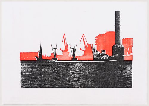
Duck Land: view of the site from the Elbe looking north, with areas proposed for demolition in red
Duck Land: view of the site from the Elbe looking north, with areas proposed for demolition in red
Actions:
Reference number:
DR2004:0893:004
DR2004:0893:004
People:
Date:
between 1989 and 1991
between 1989 and 1991
Title:
Duck Land: view of the site from the Elbe looking north, with areas proposed for demolition in red
Actions:
DR2004:0893:004
Duck Land: view of the site from the Elbe looking north, with areas proposed for demolition in red
Actions:
DR2004:0893:004
Form:
drawings
drawings
Date:
between 1989 and 1991
between 1989 and 1991
People:
Form:
photographs
photographs
Actions:
Reference number:
PH1980:0380:002
Description:
- This photograph is one in a series of views which Felice Beato made of the four Taku Forts (Harris, p. 139; Worswick, p. 138). - This photograph was made from the Great South Taku Fort looking north across the walls of the fort and the Pei (now Hai) River toward the Gulf of Chihli (now Bo Hai) (Harris, p. 143). - A copy print of this panorama under the title "Interior of South Taku Fort and Showing the Place of Landing June 25th 1859" is reproduced in Harris on pages 68-69 (cat. no. 23), and a copy print of PH1980:0380:002 (p. 167, fig. 23-3) under the title "Pei-Ho River and Taku Fort II" is reproduced in Harris on p. 167 (fig. 23-3).
People:
Subject:
architecture, engineering, military, topographic
architecture, engineering, military, topographic
Date:
between 22 August and 21 September 1860
between 22 August and 21 September 1860
Title:
View showing part of the Great South Taku Fort and the Pei (now Hai) River delta, with the Lower North Taku Fort (also known as the 2nd North Fort) in the background, Taku (now Dagu), near Tientsin (now Tianjin), China
Actions:
PH1980:0380:002
Description:
- This photograph is one in a series of views which Felice Beato made of the four Taku Forts (Harris, p. 139; Worswick, p. 138). - This photograph was made from the Great South Taku Fort looking north across the walls of the fort and the Pei (now Hai) River toward the Gulf of Chihli (now Bo Hai) (Harris, p. 143). - A copy print of this panorama under the title "Interior of South Taku Fort and Showing the Place of Landing June 25th 1859" is reproduced in Harris on pages 68-69 (cat. no. 23), and a copy print of PH1980:0380:002 (p. 167, fig. 23-3) under the title "Pei-Ho River and Taku Fort II" is reproduced in Harris on p. 167 (fig. 23-3).
Form:
photographs
photographs
Date:
between 22 August and 21 September 1860
between 22 August and 21 September 1860
People:
Subject:
architecture, engineering, military, topographic
architecture, engineering, military, topographic