7174 Results
Form:
photographs
photographs
Title:
View of St. Augustin Street looking north from St. Ambroise Street showing a train, Montréal, Québec
View of St. Augustin Street looking north from St. Ambroise Street showing a train, Montréal, Québec
Actions:
Reference number:
PH1986:1371
Description:
Commissioned by the Canadian Centre for Architecture, Montréal, for "Lachine Canal," 1985-1986.
PH1986:1371
Description:
Commissioned by the Canadian Centre for Architecture, Montréal, for "Lachine Canal," 1985-1986.
People:
Subject:
architecture
architecture
Date:
22 June 1985
22 June 1985
Title:
View of St. Augustin Street looking north from St. Ambroise Street showing a train, Montréal, Québec
Actions:
PH1986:1371
Description:
Commissioned by the Canadian Centre for Architecture, Montréal, for "Lachine Canal," 1985-1986.
View of St. Augustin Street looking north from St. Ambroise Street showing a train, Montréal, Québec
Actions:
PH1986:1371
Description:
Commissioned by the Canadian Centre for Architecture, Montréal, for "Lachine Canal," 1985-1986.
Form:
photographs
photographs
Date:
22 June 1985
22 June 1985
People:
Subject:
architecture
architecture
Form:
drawings
drawings
Actions:
Reference number:
AP056.S1.1991.PR03.021
AP056.S1.1991.PR03.021
People:
Date:
1995
1995
Title:
Area maps, plans, elevations, sections, perspective and axonometric drawings, The Westnor Development Project, North York, Ontario
Actions:
AP056.S1.1991.PR03.021
Area maps, plans, elevations, sections, perspective and axonometric drawings, The Westnor Development Project, North York, Ontario
Actions:
AP056.S1.1991.PR03.021
Form:
drawings
drawings
Date:
1995
1995
People:
Form:
drawings
drawings
Actions:
Reference number:
AP018.S1.1968.PR04.002
AP018.S1.1968.PR04.002
People:
Date:
1969-1970
1969-1970
Title:
As built site services drawings and electrical floor plans, IBM Plant Expansion Program, North York, Ontario
Actions:
AP018.S1.1968.PR04.002
As built site services drawings and electrical floor plans, IBM Plant Expansion Program, North York, Ontario
Actions:
AP018.S1.1968.PR04.002
Form:
drawings
drawings
Date:
1969-1970
1969-1970
People:
Form:
drawings
drawings
Actions:
Reference number:
AP018.S1.1970.PR01.001
AP018.S1.1970.PR01.001
People:
Date:
1970
1970
Title:
Set of construction plans, elevations, sections, and structural drawings, IBM Headquarters Building, Addition, North York, Ontario
Actions:
AP018.S1.1970.PR01.001
Set of construction plans, elevations, sections, and structural drawings, IBM Headquarters Building, Addition, North York, Ontario
Actions:
AP018.S1.1970.PR01.001
Form:
drawings
drawings
Date:
1970
1970
People:
Form:
drawings
Quantity:
5 preliminary drawing(s)
drawings
Quantity:
5 preliminary drawing(s)
Actions:
Reference number:
ARCH188392
ARCH188392
People:
Form:
drawings
Quantity:
5 preliminary drawing(s)
drawings
Quantity:
5 preliminary drawing(s)
People:
Form:
drawings, textual records
drawings, textual records
Actions:
Reference number:
AP018.S1.1978.PR17.003
AP018.S1.1978.PR17.003
People:
Date:
1979
1979
Title:
Specifications and tender form, Office Building, 1500 Don Mills Road, Signs and Graphics, North York, Ontario
Actions:
AP018.S1.1978.PR17.003
Specifications and tender form, Office Building, 1500 Don Mills Road, Signs and Graphics, North York, Ontario
Actions:
AP018.S1.1978.PR17.003
Form:
drawings, textual records
drawings, textual records
Date:
1979
1979
People:
Form:
drawings, textual records
drawings, textual records
Actions:
Reference number:
AP018.S1.1978.PR17.005
AP018.S1.1978.PR17.005
People:
Date:
1979
1979
Title:
Tender set of specifications, Office Building, 1500 Don Mills Road, Signs and Graphics, North York, Ontario
Actions:
AP018.S1.1978.PR17.005
Tender set of specifications, Office Building, 1500 Don Mills Road, Signs and Graphics, North York, Ontario
Actions:
AP018.S1.1978.PR17.005
Form:
drawings, textual records
drawings, textual records
Date:
1979
1979
People:
Form:
drawings, photographs
drawings, photographs
Reference number:
AP018.S1.1960.PR02.007
AP018.S1.1960.PR02.007
People:
Date:
circa 1962
circa 1962
Form:
drawings, photographs
drawings, photographs
Date:
circa 1962
circa 1962
People:
Form:
photographs
photographs
Actions:
Reference number:
PH1986:0901:014:001-003
Description:
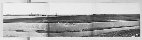
- This panorama is one in a series of views which Felice Beato made of the four Taku Forts (Harris, p. 139; Worswick, p. 138). - This panorama was made from the upper South Taku Fort looking east across the Pei (now Hai) River toward the Gulf of Chihli (now Bo Hai). The British and French combined fleet is visible on the horizon in PH1986:0901:014:002 (Harris, p. 160).
PH1986:0901:014:001-003
Description:
- This panorama is one in a series of views which Felice Beato made of the four Taku Forts (Harris, p. 139; Worswick, p. 138). - This panorama was made from the upper South Taku Fort looking east across the Pei (now Hai) River toward the Gulf of Chihli (now Bo Hai). The British and French combined fleet is visible on the horizon in PH1986:0901:014:002 (Harris, p. 160).
People:
Subject:
architecture, engineering, military, topographic
architecture, engineering, military, topographic
Date:
between 22 August and 21 September 1860
between 22 August and 21 September 1860
Title:
Panorama showing the Pei (now Hai) River delta, with the Lower North Taku Fort (also known as the 2nd North Fort) and the Great South Taku Fort in the background, Taku (now Dagu), near Tientsin (now Tianjin), China
Actions:
PH1986:0901:014:001-003
Description:
- This panorama is one in a series of views which Felice Beato made of the four Taku Forts (Harris, p. 139; Worswick, p. 138). - This panorama was made from the upper South Taku Fort looking east across the Pei (now Hai) River toward the Gulf of Chihli (now Bo Hai). The British and French combined fleet is visible on the horizon in PH1986:0901:014:002 (Harris, p. 160).
Form:
photographs
photographs
Date:
between 22 August and 21 September 1860
between 22 August and 21 September 1860
People:
Subject:
architecture, engineering, military, topographic
architecture, engineering, military, topographic
Form:
textual records
textual records
Title:
Letter from William Teron to H. P. Daniel van Ginkel for Building in the North & Mackenzie Pipeline
Letter from William Teron to H. P. Daniel van Ginkel for Building in the North & Mackenzie Pipeline
Actions:
Reference number:
ARCH400872
ARCH400872
People:
Date:
28 March 1978
28 March 1978
Form:
textual records
textual records
Date:
28 March 1978
28 March 1978
People: