35078 Results
Form:
drawings
Quantity:
15 reprographic copy(ies)
drawings
Quantity:
15 reprographic copy(ies)
Actions:
Reference number:
DR1995:0255:217
Description:
ordnance map with annotations showing bed depths, maps and plans of harbour walls, and sections through marina, wall and channel
DR1995:0255:217
Description:
ordnance map with annotations showing bed depths, maps and plans of harbour walls, and sections through marina, wall and channel
People:
Title:
Ordnance map with annotations showing bed depths, maps and plans of harbour walls
Actions:
DR1995:0255:217
Description:
ordnance map with annotations showing bed depths, maps and plans of harbour walls, and sections through marina, wall and channel
Ordnance map with annotations showing bed depths, maps and plans of harbour walls
Actions:
DR1995:0255:217
Description:
ordnance map with annotations showing bed depths, maps and plans of harbour walls, and sections through marina, wall and channel
Form:
drawings
Quantity:
15 reprographic copy(ies)
drawings
Quantity:
15 reprographic copy(ies)
People:
Form:
drawings
Quantity:
15 reprographic copy(ies)
drawings
Quantity:
15 reprographic copy(ies)
Actions:
Reference number:
DR1995:0255:218
Description:
ordnance map with annotations showing bed depths, maps and plans of harbour walls, and sections through marina, wall and channel
DR1995:0255:218
Description:
ordnance map with annotations showing bed depths, maps and plans of harbour walls, and sections through marina, wall and channel
People:
Title:
Ordnance map with annotations showing bed depths, maps and plans of harbour walls
Actions:
DR1995:0255:218
Description:
ordnance map with annotations showing bed depths, maps and plans of harbour walls, and sections through marina, wall and channel
Ordnance map with annotations showing bed depths, maps and plans of harbour walls
Actions:
DR1995:0255:218
Description:
ordnance map with annotations showing bed depths, maps and plans of harbour walls, and sections through marina, wall and channel
Form:
drawings
Quantity:
15 reprographic copy(ies)
drawings
Quantity:
15 reprographic copy(ies)
People:
Form:
textual records
textual records
Title:
Map of Malibu Beach, topographic maps, correspondence, agreement and construction permit forms
Map of Malibu Beach, topographic maps, correspondence, agreement and construction permit forms
Actions:
Reference number:
ARCH257537
Description:
1 three-ring binder - map of Malibu Beach, topographic maps, correspondence, agreement and construction permit forms, notes, construction cost estimates, catalogue of Goodstein art collection, information on elevators and sod roofs, sketches of roof plans, sections, floor plans (photocopies and diazotypes), colour photographs of study models, site and house interior photographs
People:
Date:
1984-1985
1984-1985
Title:
Map of Malibu Beach, topographic maps, correspondence, agreement and construction permit forms
Actions:
ARCH257537
Description:
1 three-ring binder - map of Malibu Beach, topographic maps, correspondence, agreement and construction permit forms, notes, construction cost estimates, catalogue of Goodstein art collection, information on elevators and sod roofs, sketches of roof plans, sections, floor plans (photocopies and diazotypes), colour photographs of study models, site and house interior photographs
Form:
textual records
textual records
Date:
1984-1985
1984-1985
People:
Form:
drawings
drawings
Actions:
Reference number:
AP140.S2.SS1.D53.P12
Description:
reference drawings including topographic map and site sections, and design development drawings including schematic floor plans, sections and axonometrics
AP140.S2.SS1.D53.P12
Description:
reference drawings including topographic map and site sections, and design development drawings including schematic floor plans, sections and axonometrics
People:
Title:
Reference drawings including topographic map and site sections
Actions:
AP140.S2.SS1.D53.P12
Description:
reference drawings including topographic map and site sections, and design development drawings including schematic floor plans, sections and axonometrics
Reference drawings including topographic map and site sections
Actions:
AP140.S2.SS1.D53.P12
Description:
reference drawings including topographic map and site sections, and design development drawings including schematic floor plans, sections and axonometrics
Form:
drawings
drawings
People:
Form:
drawings, textual records
drawings, textual records
Reference number:
DR1999:0358
Description:
documents include a map, drawings, DNA information, essays, presentation documents, transparencies, and documents relating to heating, ventilation and air conditioning
DR1999:0358
Description:
documents include a map, drawings, DNA information, essays, presentation documents, transparencies, and documents relating to heating, ventilation and air conditioning
People:
Title:
A map, drawings, DNA information, essays, presentation documents
Actions:
DR1999:0358
Description:
documents include a map, drawings, DNA information, essays, presentation documents, transparencies, and documents relating to heating, ventilation and air conditioning
A map, drawings, DNA information, essays, presentation documents
Actions:
DR1999:0358
Description:
documents include a map, drawings, DNA information, essays, presentation documents, transparencies, and documents relating to heating, ventilation and air conditioning
Form:
drawings, textual records
drawings, textual records
People:
Form:
drawings
drawings
Actions:
Reference number:
AP140.S2.SS1.D53.P11
Description:
reference drawings including topographic map and site sections, and design development drawings including schematic floor plans, sections and axonometrics, some rendered
AP140.S2.SS1.D53.P11
Description:
reference drawings including topographic map and site sections, and design development drawings including schematic floor plans, sections and axonometrics, some rendered
People:
Title:
Reference drawings including topographic map and site sections
Actions:
AP140.S2.SS1.D53.P11
Description:
reference drawings including topographic map and site sections, and design development drawings including schematic floor plans, sections and axonometrics, some rendered
Reference drawings including topographic map and site sections
Actions:
AP140.S2.SS1.D53.P11
Description:
reference drawings including topographic map and site sections, and design development drawings including schematic floor plans, sections and axonometrics, some rendered
Form:
drawings
drawings
People:
Form:
drawings
Quantity:
180 design development drawing(s)
drawings
Quantity:
180 design development drawing(s)
Actions:
Reference number:
AP140.S2.SS1.D40.P3
Description:
map, several early site plans for alternative schemes, schematic floor plans, elevations and sections, axonometrics for British Olivetti Headquarters, programmes and schedules
AP140.S2.SS1.D40.P3
Description:
map, several early site plans for alternative schemes, schematic floor plans, elevations and sections, axonometrics for British Olivetti Headquarters, programmes and schedules
People:
Title:
Map, several early site plans for alternative schemes
Actions:
AP140.S2.SS1.D40.P3
Description:
map, several early site plans for alternative schemes, schematic floor plans, elevations and sections, axonometrics for British Olivetti Headquarters, programmes and schedules
Map, several early site plans for alternative schemes
Actions:
AP140.S2.SS1.D40.P3
Description:
map, several early site plans for alternative schemes, schematic floor plans, elevations and sections, axonometrics for British Olivetti Headquarters, programmes and schedules
Form:
drawings
Quantity:
180 design development drawing(s)
drawings
Quantity:
180 design development drawing(s)
People:
Form:
drawings
Quantity:
5 reference drawing(s)
drawings
Quantity:
5 reference drawing(s)
Reference number:
DR1998:0098:103-107
DR1998:0098:103-107
People:
Form:
drawings
Quantity:
5 reference drawing(s)
drawings
Quantity:
5 reference drawing(s)
People:
Form:
maps, drawings
maps, drawings
Reference number:
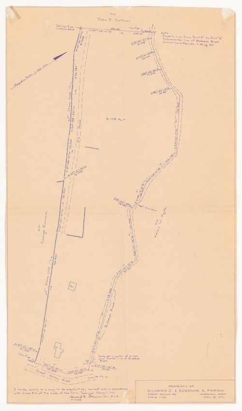
DR1994:0134:806:001
Description:
topographic survey dated "NOV. 15, 1971"
DR1994:0134:806:001
Description:
topographic survey dated "NOV. 15, 1971"
People:
Date:
15 November 1971
15 November 1971
Title:
Site map for House VI, Cornwall, Connecticut
Actions:
DR1994:0134:806:001
Description:
topographic survey dated "NOV. 15, 1971"
Site map for House VI, Cornwall, Connecticut
Actions:
DR1994:0134:806:001
Description:
topographic survey dated "NOV. 15, 1971"
Form:
maps, drawings
maps, drawings
Date:
15 November 1971
15 November 1971
People:
Form:
maps, drawings
maps, drawings
Actions:
Reference number:
ARCH279656
ARCH279656
People:
Date:
1978
1978
Form:
maps, drawings
maps, drawings
Date:
1978
1978
People: