6038 Results
Form:
photographs
photographs
Actions:
Reference number:
PH1997:0057
Description:
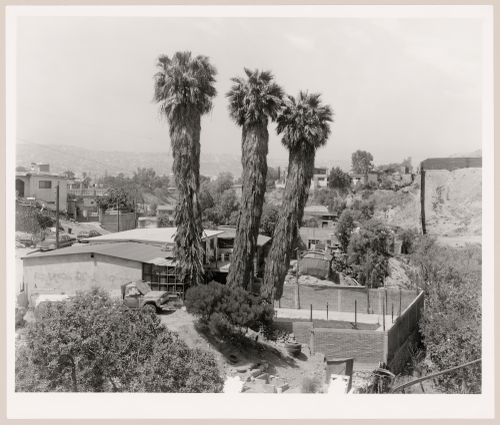
- The series "Running Fence 1997" focuses "on the first 14 miles of the border fence that separates the United States and Mexico, beginning at the Pacific Ocean and ending in the Otay Mountains.... [It] analyzes the "idea" of the border and explores its iconography, the border being a subject that is of extreme importance to the public as the world proceeds towards greater globalization. [Geoffrey] James has written of the project: "[The border fence] was built by the US Army Corps of Engineers in 1994, out of recycled metal landing strip - the most visible symbol of what is known as Operation Gatekeeper. Because the steel sheets are placed in the ground so that their ridges run horizontally, a man can hop over the fence with ease; and no Mexican child ever seems to be impeded from retrieving a soccer ball from US territory. The real barrier to illegal immigration from Mexico into the USA is less visible: hundreds of buried sensors linked to a central computer, nightscopes, helicopters and Border Patrol Agents in white Broncos."" (Evans).
PH1997:0057
Description:
- The series "Running Fence 1997" focuses "on the first 14 miles of the border fence that separates the United States and Mexico, beginning at the Pacific Ocean and ending in the Otay Mountains.... [It] analyzes the "idea" of the border and explores its iconography, the border being a subject that is of extreme importance to the public as the world proceeds towards greater globalization. [Geoffrey] James has written of the project: "[The border fence] was built by the US Army Corps of Engineers in 1994, out of recycled metal landing strip - the most visible symbol of what is known as Operation Gatekeeper. Because the steel sheets are placed in the ground so that their ridges run horizontally, a man can hop over the fence with ease; and no Mexican child ever seems to be impeded from retrieving a soccer ball from US territory. The real barrier to illegal immigration from Mexico into the USA is less visible: hundreds of buried sensors linked to a central computer, nightscopes, helicopters and Border Patrol Agents in white Broncos."" (Evans).
People:
Subject:
architecture, engineering
architecture, engineering
Date:
1997
1997
Title:
View of Colonia Libertad with trees and houses in the foreground and showing a partial view of the United States-Mexico border fence in the centre right, San Diego County, California, United States, and Colonia Libertad, Tijuana, Baja California, Mexico
Actions:
PH1997:0057
Description:
- The series "Running Fence 1997" focuses "on the first 14 miles of the border fence that separates the United States and Mexico, beginning at the Pacific Ocean and ending in the Otay Mountains.... [It] analyzes the "idea" of the border and explores its iconography, the border being a subject that is of extreme importance to the public as the world proceeds towards greater globalization. [Geoffrey] James has written of the project: "[The border fence] was built by the US Army Corps of Engineers in 1994, out of recycled metal landing strip - the most visible symbol of what is known as Operation Gatekeeper. Because the steel sheets are placed in the ground so that their ridges run horizontally, a man can hop over the fence with ease; and no Mexican child ever seems to be impeded from retrieving a soccer ball from US territory. The real barrier to illegal immigration from Mexico into the USA is less visible: hundreds of buried sensors linked to a central computer, nightscopes, helicopters and Border Patrol Agents in white Broncos."" (Evans).
Form:
photographs
photographs
Date:
1997
1997
People:
Subject:
architecture, engineering
architecture, engineering
Form:
drawings
drawings
Actions:
Reference number:
DR1987:0463
Description:
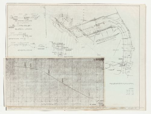
- This site plan for Swedenborg Memorial Chapel, El Cerrito, California, includes the major components of the project, such as the chapel, parking lot, recreation field and associated buildings. The site boundaries are indicated only where necessary to delineate lot subdivisions. Coloured shading distinguishes separate areas of the site, possibly for grading purposes.
DR1987:0463
Description:
- This site plan for Swedenborg Memorial Chapel, El Cerrito, California, includes the major components of the project, such as the chapel, parking lot, recreation field and associated buildings. The site boundaries are indicated only where necessary to delineate lot subdivisions. Coloured shading distinguishes separate areas of the site, possibly for grading purposes.
People:
Subject:
architecture
architecture
Date:
between 1955 and 1962
between 1955 and 1962
Title:
Swedenborg Memorial Chapel, El Cerrito, California: Partial site plan showing lot subdivision, recreation field, access road and subdivisions
Actions:
DR1987:0463
Description:
- This site plan for Swedenborg Memorial Chapel, El Cerrito, California, includes the major components of the project, such as the chapel, parking lot, recreation field and associated buildings. The site boundaries are indicated only where necessary to delineate lot subdivisions. Coloured shading distinguishes separate areas of the site, possibly for grading purposes.
Form:
drawings
drawings
Date:
between 1955 and 1962
between 1955 and 1962
People:
Subject:
architecture
architecture
Form:
drawings
drawings
Actions:
Reference number:
DR1987:0693
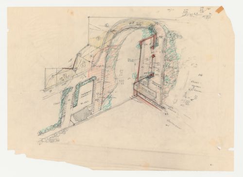
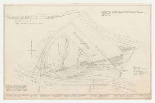
Description:
- This block plan for Wayfarers' Chapel, Palos Verdes, California, includes the new highway and shows the rectory and the triangular-plan parish house, neither of which were built. - The survey information on drawing DR1987:0693 appears to be copied by Kazio from an April 1949 survey by Charles C. Miller (probably DR1987:0679 or DR1987:0677).
DR1987:0693
Description:
- This block plan for Wayfarers' Chapel, Palos Verdes, California, includes the new highway and shows the rectory and the triangular-plan parish house, neither of which were built. - The survey information on drawing DR1987:0693 appears to be copied by Kazio from an April 1949 survey by Charles C. Miller (probably DR1987:0679 or DR1987:0677).
People:
Subject:
architecture, topographic
architecture, topographic
Date:
2 September 1954, revised 1 May 1956
2 September 1954, revised 1 May 1956
Title:
Wayfarers' Chapel, Palos Verdes, California: Site plan based on a topographic survey, with section through entrance steps showing gateway
Actions:
DR1987:0693
Description:
- This block plan for Wayfarers' Chapel, Palos Verdes, California, includes the new highway and shows the rectory and the triangular-plan parish house, neither of which were built. - The survey information on drawing DR1987:0693 appears to be copied by Kazio from an April 1949 survey by Charles C. Miller (probably DR1987:0679 or DR1987:0677).
Form:
drawings
drawings
Date:
2 September 1954, revised 1 May 1956
2 September 1954, revised 1 May 1956
People:
Subject:
architecture, topographic
architecture, topographic
Form:
photographs
photographs
Actions:
Reference number:
PH1987:0215
PH1987:0215
People:
Date:
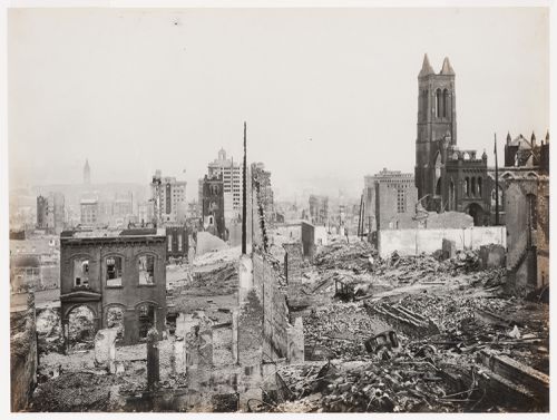
1906
1906
Form:
photographs
photographs
Date:
1906
1906
People:
Form:
photographs
photographs

Actions:
Reference number:
PH1998:0080:002
PH1998:0080:002
People:
Subject:
architecture
architecture
Date:
1952-1955
1952-1955
Title:
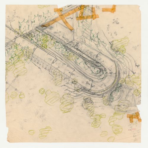
View of the spiral driveway ramp in front of the Beverly Hilton Hotel, Beverly Hills, California, United States
Actions:
PH1998:0080:002
View of the spiral driveway ramp in front of the Beverly Hilton Hotel, Beverly Hills, California, United States
Actions:
PH1998:0080:002
Form:
photographs
photographs
Date:
1952-1955
1952-1955
People:
Subject:
architecture
architecture
Form:
photographs
photographs
Actions:
Reference number:
PH1998:0104:004
PH1998:0104:004
People:
Subject:
architecture
architecture
Date:
1968-1969
1968-1969
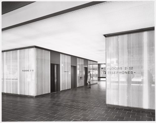
Title:
Interior view of the lobby and elevator bay of the Equitable Life Building, Los Angeles, California, United States
Actions:
PH1998:0104:004
Interior view of the lobby and elevator bay of the Equitable Life Building, Los Angeles, California, United States
Actions:
PH1998:0104:004
Form:
photographs
photographs
Date:
1968-1969
1968-1969
People:
Subject:
architecture
architecture
Form:
photographs
photographs
Actions:
Reference number:
PH1984:0977:433
Description:
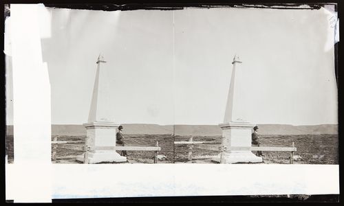
The Inital Point of Boundary Between U.S. and Mexico, with person looking over the landscape
PH1984:0977:433
Description:
The Inital Point of Boundary Between U.S. and Mexico, with person looking over the landscape
People:
Date:
ca. 1860-1880
ca. 1860-1880
Title:
Stereograph of the Inital Point of Boundary Between U.S. and Mexico, Imperial Beach, California, United States of America
Actions:
PH1984:0977:433
Description:
The Inital Point of Boundary Between U.S. and Mexico, with person looking over the landscape
Stereograph of the Inital Point of Boundary Between U.S. and Mexico, Imperial Beach, California, United States of America
Actions:
PH1984:0977:433
Description:
The Inital Point of Boundary Between U.S. and Mexico, with person looking over the landscape
Form:
photographs
photographs
Date:
ca. 1860-1880
ca. 1860-1880
People:
Form:
drawings
drawings
Actions:
Reference number:
DR1987:0701:001-002
DR1987:0701:001-002
People:
Subject:
architecture
architecture
Date:
printed during or after December 1955
printed during or after December 1955
Form:
drawings
drawings
Date:
printed during or after December 1955
printed during or after December 1955
People:
Subject:
architecture
architecture
Form:
photographs
photographs
Actions:
Reference number:
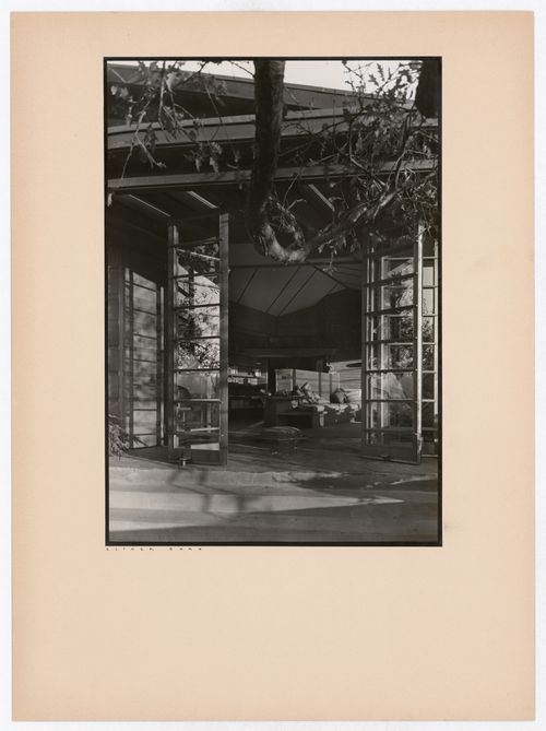
PH2004:0030
PH2004:0030
People:
Subject:
architecture, interior design
architecture, interior design
Date:
1938
1938
Form:
photographs
photographs
Date:
1938
1938
People:
Subject:
architecture, interior design
architecture, interior design
Form:
drawings
drawings
Actions:
Reference number:
DR1987:0472
Description:
- This partial site plan for Swedenborg Memorial Chapel, El Cerrito, California, shows the disposition of road and parking spaces near the chapel and also the planting plan in this area. It includes a sketch for a stage and ampitheatre below the road. The drawing may originally have continued further to the left and right, since the pencil marks continue off the sheet.
People:
Subject:
architecture
architecture
Date:
between 1955 and 1962
between 1955 and 1962
Title:
Swedenborg Memorial Chapel, El Cerrito, California: Partial sketch site plan showing parking spaces and planting next to the chapel
Actions:
DR1987:0472
Description:
- This partial site plan for Swedenborg Memorial Chapel, El Cerrito, California, shows the disposition of road and parking spaces near the chapel and also the planting plan in this area. It includes a sketch for a stage and ampitheatre below the road. The drawing may originally have continued further to the left and right, since the pencil marks continue off the sheet.
Form:
drawings
drawings
Date:
between 1955 and 1962
between 1955 and 1962
People:
Subject:
architecture
architecture