7174 Results
Form:
photographs
photographs
Actions:
Reference number:
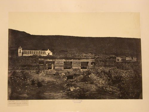
PH1981:0997:013
PH1981:0997:013
People:
Subject:
architecture, sculpture
architecture, sculpture
Date:
1859
1859
Form:
photographs
photographs
Date:
1859
1859
People:
Subject:
architecture, sculpture
architecture, sculpture
Form:
photographs
photographs
Actions:
Reference number:
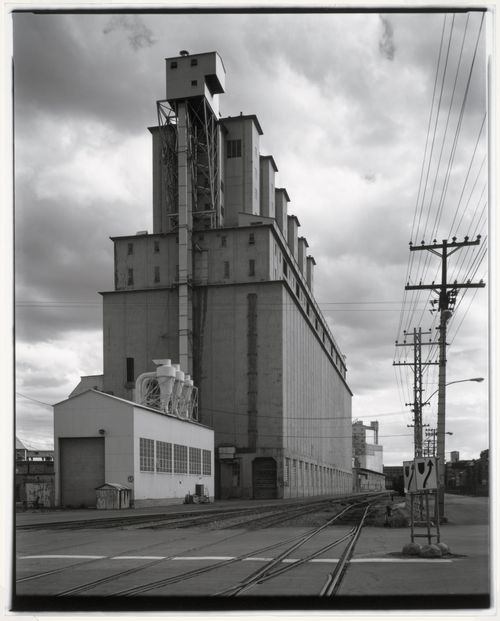
PH1979:0029
Description:
- Grain Elevator No. 2 (now demolished) was located at the foot of boulevard Saint-Laurent, Port of Montréal (Pinard, vol. 2, p. 215). Grain Elevator No. 1 (now demolished) was located at the foot of rue Saint-Sulpice, Port of Montréal (Pinard, vol. 2, p. 215).
PH1979:0029
Description:
- Grain Elevator No. 2 (now demolished) was located at the foot of boulevard Saint-Laurent, Port of Montréal (Pinard, vol. 2, p. 215). Grain Elevator No. 1 (now demolished) was located at the foot of rue Saint-Sulpice, Port of Montréal (Pinard, vol. 2, p. 215).
People:
Subject:
architecture, engineering
architecture, engineering
Date:
August 1976
August 1976
Title:
View of the east and north façades of Grain Elevator No. 2 (now demolished) showing the shed and railway tracks in the foreground, and Grain Elevator No. 1 (now demolished) in the background, Port of Montréal, Québec
Actions:
PH1979:0029
Description:
- Grain Elevator No. 2 (now demolished) was located at the foot of boulevard Saint-Laurent, Port of Montréal (Pinard, vol. 2, p. 215). Grain Elevator No. 1 (now demolished) was located at the foot of rue Saint-Sulpice, Port of Montréal (Pinard, vol. 2, p. 215).
Form:
photographs
photographs
Date:
August 1976
August 1976
People:
Subject:
architecture, engineering
architecture, engineering
Form:
photographs
photographs
Actions:
Reference number:
PH1982:0347:005
PH1982:0347:005
People:
Subject:
architecture
architecture
Date:
ca. 1870
ca. 1870
Form:
photographs
photographs
Date:
ca. 1870
ca. 1870
People:
Subject:
architecture
architecture
Form:
drawings
drawings

Actions:
Reference number:
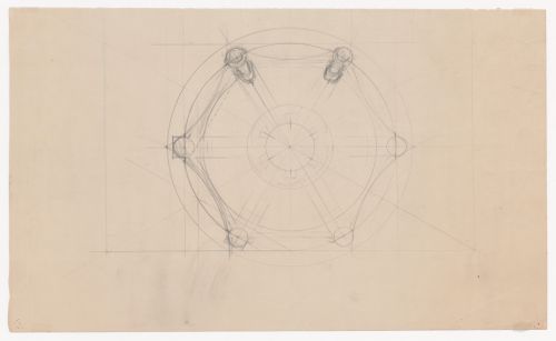
DR1984:0279 R/V
DR1984:0279 R/V
People:
Subject:
architecture, military
architecture, military
Date:
printed 1931
printed 1931
Form:
drawings
drawings
Date:
printed 1931
printed 1931
People:
Subject:
architecture, military
architecture, military
Form:
drawings
drawings
Actions:
Reference number:
DR1984:0288 R/V
DR1984:0288 R/V
People:
Subject:
architecture, military
architecture, military
Date:
printed 1931
printed 1931
Form:
drawings
drawings
Date:
printed 1931
printed 1931
People:
Subject:
architecture, military
architecture, military
Form:
photographs
photographs
Actions:
Reference number:
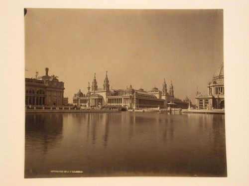
PH1981:0493
Description:
- This photograph shows a bridge connecting the Machinery Hall to the Agricultural Building across the South Canal.
PH1981:0493
Description:
- This photograph shows a bridge connecting the Machinery Hall to the Agricultural Building across the South Canal.
People:
Subject:
architecture
architecture
Date:
1893
1893
Title:
View of the north and east façades of the Machinery Hall showing the Agricultural Building on the left and the Administration Building on the right from across the Grand Basin, 1893 Chicago World's Columbian Exhibition, Chicago, Illinois
Actions:
PH1981:0493
Description:
- This photograph shows a bridge connecting the Machinery Hall to the Agricultural Building across the South Canal.
Form:
photographs
photographs
Date:
1893
1893
People:
Subject:
architecture
architecture
Form:
photographs
Quantity:
282 File
photographs
Quantity:
282 File
Actions:
Reference number:
ARCH273947
ARCH273947
People:
Date:
1970s
1970s
Form:
photographs
Quantity:
282 File
photographs
Quantity:
282 File
Date:
1970s
1970s
People:
Form:
textual records
textual records
Actions:
Reference number:
DR1995:0188:879
DR1995:0188:879
People:
Date:
ca. 1965
ca. 1965
Form:
textual records
textual records
Date:
ca. 1965
ca. 1965
People:
Form:
photographs
photographs
Actions:
Reference number:
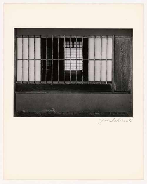
PH1986:0258
Description:
- Photographs PH1986:0148 - PH1986:0283 form a sequence of views. Accession numbers follow an order established by the photographer that is based on the temporal experience of walking through the grounds of Katsura Rikyu (also known as Katsura Imperial Villa) (see acquisition file). - Yasuhiro Ishimoto returned to Katsura Rikyu (also known as Katsura Imperial Villa) in 1982 and took another series of photographs, this time with many in colour, often using the same or very similar views to those of his 1953 photographs at the same location (Ishimoto, p. 266).
People:
Subject:
architecture
architecture
Date:
1953
1953
Title:
View of a window with shoji and bamboo mullions on the north side of the Shoiken showing the interior of the Third Room (also known as the Anteroom), Katsura Rikyu (also known as Katsura Imperial Villa), Kyoto, Japan
Actions:
PH1986:0258
Description:
- Photographs PH1986:0148 - PH1986:0283 form a sequence of views. Accession numbers follow an order established by the photographer that is based on the temporal experience of walking through the grounds of Katsura Rikyu (also known as Katsura Imperial Villa) (see acquisition file). - Yasuhiro Ishimoto returned to Katsura Rikyu (also known as Katsura Imperial Villa) in 1982 and took another series of photographs, this time with many in colour, often using the same or very similar views to those of his 1953 photographs at the same location (Ishimoto, p. 266).
Form:
photographs
photographs
Date:
1953
1953
People:
Subject:
architecture
architecture
Form:
photographs
photographs
![Panoramic view of a section of the Imperial City showing Jade Flowery Island [Qionghua Dao], the White Pagoda [Bai Ta], part of North Lake [Beihai] and other structures in the Western Garden (now Beihai Park), Peking (now Beijing), China](/img-collection/Ff4oUOqv3xykwxhxV0teYbF2k9s=/500x391/13873.jpg)
Actions:
Reference number:
PH1986:0901:039
Description:
- This photograph was taken from the top of Jingshan [Hill of Commanding Views] (also known as Coal Hill [Meishan] and Prospect Hill) looking northwest. - At the time the photo was taken, the North Lake [Beihai], which is visible at centre right, had been drained (Harris, p. 148). The East Gate to Western Garden [Xi Yuan] (now Beihai Park) is visible slightly left of centre and the conical roofed building at centre left is the northern-most building within the Daoist Ta-kao hsuan Hall (now Dagaoxuan Dian) temple complex.
People:
Subject:
architecture, landscape architecture, topographic
architecture, landscape architecture, topographic
Date:
29 October 1860
29 October 1860
Title:
Panoramic view of a section of the Imperial City showing Jade Flowery Island [Qionghua Dao], the White Pagoda [Bai Ta], part of North Lake [Beihai] and other structures in the Western Garden (now Beihai Park), Peking (now Beijing), China
Actions:
PH1986:0901:039
Description:
- This photograph was taken from the top of Jingshan [Hill of Commanding Views] (also known as Coal Hill [Meishan] and Prospect Hill) looking northwest. - At the time the photo was taken, the North Lake [Beihai], which is visible at centre right, had been drained (Harris, p. 148). The East Gate to Western Garden [Xi Yuan] (now Beihai Park) is visible slightly left of centre and the conical roofed building at centre left is the northern-most building within the Daoist Ta-kao hsuan Hall (now Dagaoxuan Dian) temple complex.
Form:
photographs
photographs
Date:
29 October 1860
29 October 1860
People:
Subject:
architecture, landscape architecture, topographic
architecture, landscape architecture, topographic