


7241 Results
Form:
photographs
photographs
Actions:
Reference number:
PH1980:1220:036
Description:
- The tomb of Ibrahim Adil Shah II, his wife and children is pictured. Behind it is the mosque that forms part of the Rauza. To the far right are the minarets of the northern gateway. The photographer was facing west north west.
PH1980:1220:036
Description:
- The tomb of Ibrahim Adil Shah II, his wife and children is pictured. Behind it is the mosque that forms part of the Rauza. To the far right are the minarets of the northern gateway. The photographer was facing west north west.
People:
Subject:
architecture
architecture
Date:
March - April 1855
March - April 1855
Title:
View of the Mausoleum of Ibrahim Adil Shah II showing the mosque on the far left and the minarets of the northern gateway on the far right, Ibrahim Rauza complex, Beejapore (now Bijapur), India
Actions:
PH1980:1220:036
Description:
- The tomb of Ibrahim Adil Shah II, his wife and children is pictured. Behind it is the mosque that forms part of the Rauza. To the far right are the minarets of the northern gateway. The photographer was facing west north west.
View of the Mausoleum of Ibrahim Adil Shah II showing the mosque on the far left and the minarets of the northern gateway on the far right, Ibrahim Rauza complex, Beejapore (now Bijapur), India
Actions:
PH1980:1220:036
Description:
- The tomb of Ibrahim Adil Shah II, his wife and children is pictured. Behind it is the mosque that forms part of the Rauza. To the far right are the minarets of the northern gateway. The photographer was facing west north west.
Form:
photographs
photographs
Date:
March - April 1855
March - April 1855
People:
Subject:
architecture
architecture
Level of archival description:
Project
Project
Reference number:
AP056.S1.1994.PR03
Description:
This project series documents a park in Oakville, Ontario in 1994. The office identified the project number as 9401. This project was the winning entry in a competition to design a park in an area known as the Uptown Core, which was undergoing major transformations at the time. The park, now known as Oak Park, stretched several blocks north-east from the Sixth Line. The large part of the design included a greenhouse pavilion overlooking a lake, accompanied by a bridge that extended south-west towards a wooded area. The project is recorded through drawings and presentation watercolour paintings dating from around 1994. The drawings are mostly originals and primarily include site surveys, sketches, plans, elevations and perspectives.
AP056.S1.1994.PR03
Description:
This project series documents a park in Oakville, Ontario in 1994. The office identified the project number as 9401. This project was the winning entry in a competition to design a park in an area known as the Uptown Core, which was undergoing major transformations at the time. The park, now known as Oak Park, stretched several blocks north-east from the Sixth Line. The large part of the design included a greenhouse pavilion overlooking a lake, accompanied by a bridge that extended south-west towards a wooded area. The project is recorded through drawings and presentation watercolour paintings dating from around 1994. The drawings are mostly originals and primarily include site surveys, sketches, plans, elevations and perspectives.
People:
Date:
circa 1994
circa 1994
Title:
Oakville Parks, Oakville, Ontario (1994)
Actions:
AP056.S1.1994.PR03
Description:
This project series documents a park in Oakville, Ontario in 1994. The office identified the project number as 9401. This project was the winning entry in a competition to design a park in an area known as the Uptown Core, which was undergoing major transformations at the time. The park, now known as Oak Park, stretched several blocks north-east from the Sixth Line. The large part of the design included a greenhouse pavilion overlooking a lake, accompanied by a bridge that extended south-west towards a wooded area. The project is recorded through drawings and presentation watercolour paintings dating from around 1994. The drawings are mostly originals and primarily include site surveys, sketches, plans, elevations and perspectives.
Oakville Parks, Oakville, Ontario (1994)
Actions:
AP056.S1.1994.PR03
Description:
This project series documents a park in Oakville, Ontario in 1994. The office identified the project number as 9401. This project was the winning entry in a competition to design a park in an area known as the Uptown Core, which was undergoing major transformations at the time. The park, now known as Oak Park, stretched several blocks north-east from the Sixth Line. The large part of the design included a greenhouse pavilion overlooking a lake, accompanied by a bridge that extended south-west towards a wooded area. The project is recorded through drawings and presentation watercolour paintings dating from around 1994. The drawings are mostly originals and primarily include site surveys, sketches, plans, elevations and perspectives.
Level of archival description:
Project
Project
Date:
circa 1994
circa 1994
People:
Level of archival description:
Project
Project
Actions:
Reference number:
AP075.S1.2008.PR01
Description:
Project series documents Cornelia Hahn Oberlander's landscape project for the Leon and Thea Koerner University Centre at the University of British Columbia, in Vancouver. Oberlander worked on this project in 2013-2015 with architectural firm B Gordon Hlynsky Architect, who design the building located on North West Marine Drive. Oberlander's work consisted in designing the green space at the entrance of the building. Her landscape design included a concrete pathway linking the existing rose garden situated next to the building and the new building entrance, and rearraging the planting of existing rhododendrons and azaleas. The project series contains four lower floor plans showing landscape, correspondence, including correspondence with architects, specifications and financial documents.
AP075.S1.2008.PR01
Description:
Project series documents Cornelia Hahn Oberlander's landscape project for the Leon and Thea Koerner University Centre at the University of British Columbia, in Vancouver. Oberlander worked on this project in 2013-2015 with architectural firm B Gordon Hlynsky Architect, who design the building located on North West Marine Drive. Oberlander's work consisted in designing the green space at the entrance of the building. Her landscape design included a concrete pathway linking the existing rose garden situated next to the building and the new building entrance, and rearraging the planting of existing rhododendrons and azaleas. The project series contains four lower floor plans showing landscape, correspondence, including correspondence with architects, specifications and financial documents.
People:
Date:
2008-2015
2008-2015
Title:
Leon and Thea Koerner University Centre lower level, University of British Columbia, Vancouver, British Columbia (2008)
Actions:
AP075.S1.2008.PR01
Description:
Project series documents Cornelia Hahn Oberlander's landscape project for the Leon and Thea Koerner University Centre at the University of British Columbia, in Vancouver. Oberlander worked on this project in 2013-2015 with architectural firm B Gordon Hlynsky Architect, who design the building located on North West Marine Drive. Oberlander's work consisted in designing the green space at the entrance of the building. Her landscape design included a concrete pathway linking the existing rose garden situated next to the building and the new building entrance, and rearraging the planting of existing rhododendrons and azaleas. The project series contains four lower floor plans showing landscape, correspondence, including correspondence with architects, specifications and financial documents.
Leon and Thea Koerner University Centre lower level, University of British Columbia, Vancouver, British Columbia (2008)
Actions:
AP075.S1.2008.PR01
Description:
Project series documents Cornelia Hahn Oberlander's landscape project for the Leon and Thea Koerner University Centre at the University of British Columbia, in Vancouver. Oberlander worked on this project in 2013-2015 with architectural firm B Gordon Hlynsky Architect, who design the building located on North West Marine Drive. Oberlander's work consisted in designing the green space at the entrance of the building. Her landscape design included a concrete pathway linking the existing rose garden situated next to the building and the new building entrance, and rearraging the planting of existing rhododendrons and azaleas. The project series contains four lower floor plans showing landscape, correspondence, including correspondence with architects, specifications and financial documents.
Level of archival description:
Project
Project
Date:
2008-2015
2008-2015
People:
Level of archival description:
Project
Project
Actions:
Reference number:
AP018.S1.1979.PR04
Description:
This project series documents the new executive offices of J. Douglas Crashley in Toronto from 1979-1980. The office identified the project number as 7904. This project consisted of changes made to the 29th floor of Toronto office building Commerce Court North in order to accommodate the new executive offices of Central Precision Ltd., where J. Douglas Crashley was the director. The office layout included Crashley's office and other office spaces, reception, a file room, a kitchenette and conference room. The project is recorded through drawings and textual materials dating from 1974-1980. The drawings mostly consist of reprographic copies of layouts and floor plans. The textual records consist of financial records.
AP018.S1.1979.PR04
Description:
This project series documents the new executive offices of J. Douglas Crashley in Toronto from 1979-1980. The office identified the project number as 7904. This project consisted of changes made to the 29th floor of Toronto office building Commerce Court North in order to accommodate the new executive offices of Central Precision Ltd., where J. Douglas Crashley was the director. The office layout included Crashley's office and other office spaces, reception, a file room, a kitchenette and conference room. The project is recorded through drawings and textual materials dating from 1974-1980. The drawings mostly consist of reprographic copies of layouts and floor plans. The textual records consist of financial records.
People:
Date:
1974-1980
1974-1980
Title:
New Executive Offices of J.D. Crashley, Toronto (1979-1980)
Actions:
AP018.S1.1979.PR04
Description:
This project series documents the new executive offices of J. Douglas Crashley in Toronto from 1979-1980. The office identified the project number as 7904. This project consisted of changes made to the 29th floor of Toronto office building Commerce Court North in order to accommodate the new executive offices of Central Precision Ltd., where J. Douglas Crashley was the director. The office layout included Crashley's office and other office spaces, reception, a file room, a kitchenette and conference room. The project is recorded through drawings and textual materials dating from 1974-1980. The drawings mostly consist of reprographic copies of layouts and floor plans. The textual records consist of financial records.
New Executive Offices of J.D. Crashley, Toronto (1979-1980)
Actions:
AP018.S1.1979.PR04
Description:
This project series documents the new executive offices of J. Douglas Crashley in Toronto from 1979-1980. The office identified the project number as 7904. This project consisted of changes made to the 29th floor of Toronto office building Commerce Court North in order to accommodate the new executive offices of Central Precision Ltd., where J. Douglas Crashley was the director. The office layout included Crashley's office and other office spaces, reception, a file room, a kitchenette and conference room. The project is recorded through drawings and textual materials dating from 1974-1980. The drawings mostly consist of reprographic copies of layouts and floor plans. The textual records consist of financial records.
Level of archival description:
Project
Project
Date:
1974-1980
1974-1980
People:
Form:
works of art
works of art
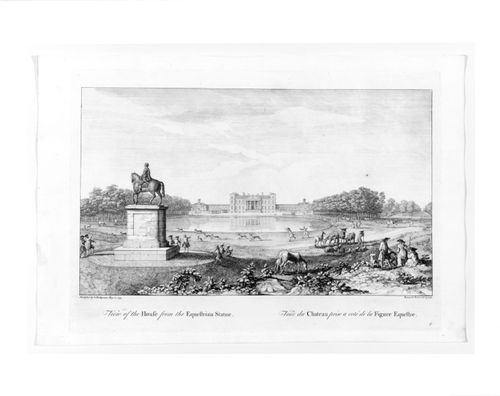
Actions:
Reference number:
DR1982:0096:006
Description:
- A view, reversing that of Plate 5, of the north front of the house and with an equestrian statue in the left foreground. - The marbled and leather-edged portfolio in which the prints were acquired is stored separately in a solander box (size IV).
DR1982:0096:006
Description:
- A view, reversing that of Plate 5, of the north front of the house and with an equestrian statue in the left foreground. - The marbled and leather-edged portfolio in which the prints were acquired is stored separately in a solander box (size IV).
People:
Subject:
architecture, landscape architecture, topographic
architecture, landscape architecture, topographic
Date:
designed 1733-1738
designed 1733-1738
Title:
View of the House from the Equestrian Statue
Actions:
DR1982:0096:006
Description:
- A view, reversing that of Plate 5, of the north front of the house and with an equestrian statue in the left foreground. - The marbled and leather-edged portfolio in which the prints were acquired is stored separately in a solander box (size IV).
View of the House from the Equestrian Statue
Actions:
DR1982:0096:006
Description:
- A view, reversing that of Plate 5, of the north front of the house and with an equestrian statue in the left foreground. - The marbled and leather-edged portfolio in which the prints were acquired is stored separately in a solander box (size IV).
Form:
works of art
works of art
Date:
designed 1733-1738
designed 1733-1738
People:
Subject:
architecture, landscape architecture, topographic
architecture, landscape architecture, topographic
Level of archival description:
Project
Project
Actions:
Reference number:
AP018.S1.1969.PR04
Description:
This project series documents the master plan for the future Art Gallery of Ontario (AGO) expansion projects in Toronto in 1969. The office identified the project number as 69035. This project outlines the complete master plan for future expansions of the gallery. For decades, the AGO, under its previous name, The Art Gallery of Toronto, consisted of the nineteenth century Grange mansion and a gallery to its north. The project shows the growth of the AGO from two small buildings surrounded by parks to a much larger two storey building that would touch Dundas Street to the north, Beverly Street to the West, and McCaul Street and the Ontario College of Art to the East. In total, three stages were proposed in this plan to increase the AGO sevenfold from 32,000 square feet of gallery space to 253,000 square feet. In addition, a parking lot was proposed in the Dundas Street Mall to the east of the gallery. Originally, the stages were known in the documentation as Phases I, II, III, and IA but their names evolved with the project. Each stage was eventually given its own project number by the office and the original master plan documented in this project series changed in size and design over the years. This project contract was originally given to John B. Parkin Associates. However, John C. Parkin continued the project under his new firm, Parkin Architects Planners, after parting ways with partner John B. Parkin in 1971. The project is recorded through drawings, including presentation boards, dating from 1965-1978. The majority of these are original drawings showing the design planning of the art gallery.
AP018.S1.1969.PR04
Description:
This project series documents the master plan for the future Art Gallery of Ontario (AGO) expansion projects in Toronto in 1969. The office identified the project number as 69035. This project outlines the complete master plan for future expansions of the gallery. For decades, the AGO, under its previous name, The Art Gallery of Toronto, consisted of the nineteenth century Grange mansion and a gallery to its north. The project shows the growth of the AGO from two small buildings surrounded by parks to a much larger two storey building that would touch Dundas Street to the north, Beverly Street to the West, and McCaul Street and the Ontario College of Art to the East. In total, three stages were proposed in this plan to increase the AGO sevenfold from 32,000 square feet of gallery space to 253,000 square feet. In addition, a parking lot was proposed in the Dundas Street Mall to the east of the gallery. Originally, the stages were known in the documentation as Phases I, II, III, and IA but their names evolved with the project. Each stage was eventually given its own project number by the office and the original master plan documented in this project series changed in size and design over the years. This project contract was originally given to John B. Parkin Associates. However, John C. Parkin continued the project under his new firm, Parkin Architects Planners, after parting ways with partner John B. Parkin in 1971. The project is recorded through drawings, including presentation boards, dating from 1965-1978. The majority of these are original drawings showing the design planning of the art gallery.
People:
Date:
1965-1981
1965-1981
Title:
Art Gallery of Ontario, The Master Plan, Toronto (1969)
Actions:
AP018.S1.1969.PR04
Description:
This project series documents the master plan for the future Art Gallery of Ontario (AGO) expansion projects in Toronto in 1969. The office identified the project number as 69035. This project outlines the complete master plan for future expansions of the gallery. For decades, the AGO, under its previous name, The Art Gallery of Toronto, consisted of the nineteenth century Grange mansion and a gallery to its north. The project shows the growth of the AGO from two small buildings surrounded by parks to a much larger two storey building that would touch Dundas Street to the north, Beverly Street to the West, and McCaul Street and the Ontario College of Art to the East. In total, three stages were proposed in this plan to increase the AGO sevenfold from 32,000 square feet of gallery space to 253,000 square feet. In addition, a parking lot was proposed in the Dundas Street Mall to the east of the gallery. Originally, the stages were known in the documentation as Phases I, II, III, and IA but their names evolved with the project. Each stage was eventually given its own project number by the office and the original master plan documented in this project series changed in size and design over the years. This project contract was originally given to John B. Parkin Associates. However, John C. Parkin continued the project under his new firm, Parkin Architects Planners, after parting ways with partner John B. Parkin in 1971. The project is recorded through drawings, including presentation boards, dating from 1965-1978. The majority of these are original drawings showing the design planning of the art gallery.
Art Gallery of Ontario, The Master Plan, Toronto (1969)
Actions:
AP018.S1.1969.PR04
Description:
This project series documents the master plan for the future Art Gallery of Ontario (AGO) expansion projects in Toronto in 1969. The office identified the project number as 69035. This project outlines the complete master plan for future expansions of the gallery. For decades, the AGO, under its previous name, The Art Gallery of Toronto, consisted of the nineteenth century Grange mansion and a gallery to its north. The project shows the growth of the AGO from two small buildings surrounded by parks to a much larger two storey building that would touch Dundas Street to the north, Beverly Street to the West, and McCaul Street and the Ontario College of Art to the East. In total, three stages were proposed in this plan to increase the AGO sevenfold from 32,000 square feet of gallery space to 253,000 square feet. In addition, a parking lot was proposed in the Dundas Street Mall to the east of the gallery. Originally, the stages were known in the documentation as Phases I, II, III, and IA but their names evolved with the project. Each stage was eventually given its own project number by the office and the original master plan documented in this project series changed in size and design over the years. This project contract was originally given to John B. Parkin Associates. However, John C. Parkin continued the project under his new firm, Parkin Architects Planners, after parting ways with partner John B. Parkin in 1971. The project is recorded through drawings, including presentation boards, dating from 1965-1978. The majority of these are original drawings showing the design planning of the art gallery.
Level of archival description:
Project
Project
Date:
1965-1981
1965-1981
People:
Level of archival description:
Project
Project
Actions:
Reference number:
AP075.S1.2005.PR05
Description:
Project series documents Cornelia Hahn Oberlander's project for the Harry & Jeanette Weinberg Jewish Community Campus, a high school and community facility on Willow Street, at the corne of 41st Avenue, in Vancouver, British Columbia. Oberlander worked on this project from 2005-2007 with architectural firm Acton Ostry Architects. The landscape project comprises the addition of trees along 41st Avenue and Willow Street, while preserving existing ones, and the design of three paved terraces along the north side of the building and creating the planting plant, that included a rainwater garden next to the east terrace. The project series contains solely four site and planting plans with plants list, and a detail section plan for the terraces.
AP075.S1.2005.PR05
Description:
Project series documents Cornelia Hahn Oberlander's project for the Harry & Jeanette Weinberg Jewish Community Campus, a high school and community facility on Willow Street, at the corne of 41st Avenue, in Vancouver, British Columbia. Oberlander worked on this project from 2005-2007 with architectural firm Acton Ostry Architects. The landscape project comprises the addition of trees along 41st Avenue and Willow Street, while preserving existing ones, and the design of three paved terraces along the north side of the building and creating the planting plant, that included a rainwater garden next to the east terrace. The project series contains solely four site and planting plans with plants list, and a detail section plan for the terraces.
People:
Date:
2005-2007
2005-2007
Title:
Harry & Jeanette Weinberg Jewish Community Campus, Vancouver, British Columbia (2005)
Actions:
AP075.S1.2005.PR05
Description:
Project series documents Cornelia Hahn Oberlander's project for the Harry & Jeanette Weinberg Jewish Community Campus, a high school and community facility on Willow Street, at the corne of 41st Avenue, in Vancouver, British Columbia. Oberlander worked on this project from 2005-2007 with architectural firm Acton Ostry Architects. The landscape project comprises the addition of trees along 41st Avenue and Willow Street, while preserving existing ones, and the design of three paved terraces along the north side of the building and creating the planting plant, that included a rainwater garden next to the east terrace. The project series contains solely four site and planting plans with plants list, and a detail section plan for the terraces.
Harry & Jeanette Weinberg Jewish Community Campus, Vancouver, British Columbia (2005)
Actions:
AP075.S1.2005.PR05
Description:
Project series documents Cornelia Hahn Oberlander's project for the Harry & Jeanette Weinberg Jewish Community Campus, a high school and community facility on Willow Street, at the corne of 41st Avenue, in Vancouver, British Columbia. Oberlander worked on this project from 2005-2007 with architectural firm Acton Ostry Architects. The landscape project comprises the addition of trees along 41st Avenue and Willow Street, while preserving existing ones, and the design of three paved terraces along the north side of the building and creating the planting plant, that included a rainwater garden next to the east terrace. The project series contains solely four site and planting plans with plants list, and a detail section plan for the terraces.
Level of archival description:
Project
Project
Date:
2005-2007
2005-2007
People:
Form:
drawings
Quantity:
19 drawing(s)
drawings
Quantity:
19 drawing(s)
Actions:
Reference number:
ARCH262394
Description:
Offices looking north facing Hall Viger (10) overlays (1:200) (1) overlay (1:200) (2) overlays (1:100) (1) section overlay northwest corner facing Hall Viger and China town (1:200) (2) overlays (1) overlay (2) looses studies
ARCH262394
Description:
Offices looking north facing Hall Viger (10) overlays (1:200) (1) overlay (1:200) (2) overlays (1:100) (1) section overlay northwest corner facing Hall Viger and China town (1:200) (2) overlays (1) overlay (2) looses studies
People:
Title:
Mezzanine plan studies (25 300)
Actions:
ARCH262394
Description:
Offices looking north facing Hall Viger (10) overlays (1:200) (1) overlay (1:200) (2) overlays (1:100) (1) section overlay northwest corner facing Hall Viger and China town (1:200) (2) overlays (1) overlay (2) looses studies
Mezzanine plan studies (25 300)
Actions:
ARCH262394
Description:
Offices looking north facing Hall Viger (10) overlays (1:200) (1) overlay (1:200) (2) overlays (1:100) (1) section overlay northwest corner facing Hall Viger and China town (1:200) (2) overlays (1) overlay (2) looses studies
Form:
drawings
Quantity:
19 drawing(s)
drawings
Quantity:
19 drawing(s)
People:
Form:
drawings
Quantity:
34 File
drawings
Quantity:
34 File
Actions:
Reference number:
ARCH79789
Description:
early schematic plan sketches and building sections showing variations in design concept, north elevation studies, sketch plans and details, schematic plan showing square footages and ramp section with attached sheet of calculations, site and ste / floor plans showing land contours
ARCH79789
Description:
early schematic plan sketches and building sections showing variations in design concept, north elevation studies, sketch plans and details, schematic plan showing square footages and ramp section with attached sheet of calculations, site and ste / floor plans showing land contours
People:
Date:
circa 1947-2002
circa 1947-2002
Title:
Early schematic plan sketches and building sections showing variations in design concept
Actions:
ARCH79789
Description:
early schematic plan sketches and building sections showing variations in design concept, north elevation studies, sketch plans and details, schematic plan showing square footages and ramp section with attached sheet of calculations, site and ste / floor plans showing land contours
Early schematic plan sketches and building sections showing variations in design concept
Actions:
ARCH79789
Description:
early schematic plan sketches and building sections showing variations in design concept, north elevation studies, sketch plans and details, schematic plan showing square footages and ramp section with attached sheet of calculations, site and ste / floor plans showing land contours
Form:
drawings
Quantity:
34 File
drawings
Quantity:
34 File
Date:
circa 1947-2002
circa 1947-2002
People:
Form:
photographs
photographs
Reference number:
ARCH275848
Description:
2 binders- photographic documentation for projects filed under, "Planning and Urban Design." Includes: L.A. Metro Rail Station, Tanjung Batu, Centennial Campus, North Carolina, New West Quay, Marathon Lands Study and Bayshore Gardens. Includes project information, renderings, presentation slides and plans.
ARCH275848
Description:
2 binders- photographic documentation for projects filed under, "Planning and Urban Design." Includes: L.A. Metro Rail Station, Tanjung Batu, Centennial Campus, North Carolina, New West Quay, Marathon Lands Study and Bayshore Gardens. Includes project information, renderings, presentation slides and plans.
People:
Date:
1990
1990
Title:
Photographic documentation for various projects
Actions:
ARCH275848
Description:
2 binders- photographic documentation for projects filed under, "Planning and Urban Design." Includes: L.A. Metro Rail Station, Tanjung Batu, Centennial Campus, North Carolina, New West Quay, Marathon Lands Study and Bayshore Gardens. Includes project information, renderings, presentation slides and plans.
Photographic documentation for various projects
Actions:
ARCH275848
Description:
2 binders- photographic documentation for projects filed under, "Planning and Urban Design." Includes: L.A. Metro Rail Station, Tanjung Batu, Centennial Campus, North Carolina, New West Quay, Marathon Lands Study and Bayshore Gardens. Includes project information, renderings, presentation slides and plans.
Form:
photographs
photographs
Date:
1990
1990
People:


