270 Results
Form:
drawings
drawings
Actions:
Reference number:
ARCH260645
Description:
Roll of reference material - topographical map of Tumbler Ridge, Victoria, B.C.; poster of the Spiral Jetty in Great Salt Lake by Robert Smithson; original drawings of the Royal Bank of Canada Building on Hastings and Granville by S.G. Davenport (Vancouver, 1929).
ARCH260645
Description:
Roll of reference material - topographical map of Tumbler Ridge, Victoria, B.C.; poster of the Spiral Jetty in Great Salt Lake by Robert Smithson; original drawings of the Royal Bank of Canada Building on Hastings and Granville by S.G. Davenport (Vancouver, 1929).
People:
Title:
Reference material for various projects
Actions:
ARCH260645
Description:
Roll of reference material - topographical map of Tumbler Ridge, Victoria, B.C.; poster of the Spiral Jetty in Great Salt Lake by Robert Smithson; original drawings of the Royal Bank of Canada Building on Hastings and Granville by S.G. Davenport (Vancouver, 1929).
Form:
drawings
drawings
People:
Form:
drawings
drawings
Actions:
Reference number:
DR1985:0415
Description:
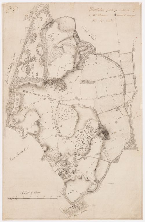
- DR1985:0415 presents a cartographic survey of Wimbledon Park as "improved" in the second half of the eighteenth century. Covering some 1,200 acres, the park as shown in this plan contains all the elements of Capability Brown's mature landscape style: expanses of grass traversed by meandering paths, irregular plantings of trees placed singly and in clumps, and winding streams dammed to create a large, irregular lake near the centre of the property and several small ponds about the periphery. The main house (built 1732-33 for Sarah, the Duchess of Marlborough), its outbuildings, and the village church are shown at the southern end of the park, as is a kitchen garden dating from an earlier period. Roads, lanes, and neighbouring properties are neatly labelled in the draughtsman's hand, and the fall of the land has been indicated in shade lines.
DR1985:0415
Description:
- DR1985:0415 presents a cartographic survey of Wimbledon Park as "improved" in the second half of the eighteenth century. Covering some 1,200 acres, the park as shown in this plan contains all the elements of Capability Brown's mature landscape style: expanses of grass traversed by meandering paths, irregular plantings of trees placed singly and in clumps, and winding streams dammed to create a large, irregular lake near the centre of the property and several small ponds about the periphery. The main house (built 1732-33 for Sarah, the Duchess of Marlborough), its outbuildings, and the village church are shown at the southern end of the park, as is a kitchen garden dating from an earlier period. Roads, lanes, and neighbouring properties are neatly labelled in the draughtsman's hand, and the fall of the land has been indicated in shade lines.
People:
Subject:
landscape architecture, topographic
landscape architecture, topographic
Date:
between 1765 and 1785
between 1765 and 1785
Title:
A survey plan of Wimbledon Park as designed for Lord Spencer by Capability Brown
Actions:
DR1985:0415
Description:
- DR1985:0415 presents a cartographic survey of Wimbledon Park as "improved" in the second half of the eighteenth century. Covering some 1,200 acres, the park as shown in this plan contains all the elements of Capability Brown's mature landscape style: expanses of grass traversed by meandering paths, irregular plantings of trees placed singly and in clumps, and winding streams dammed to create a large, irregular lake near the centre of the property and several small ponds about the periphery. The main house (built 1732-33 for Sarah, the Duchess of Marlborough), its outbuildings, and the village church are shown at the southern end of the park, as is a kitchen garden dating from an earlier period. Roads, lanes, and neighbouring properties are neatly labelled in the draughtsman's hand, and the fall of the land has been indicated in shade lines.
Form:
drawings
drawings
Date:
between 1765 and 1785
between 1765 and 1785
People:
Subject:
landscape architecture, topographic
landscape architecture, topographic
Form:
drawings
drawings
Actions:
Reference number:
DR1985:0416
Description:
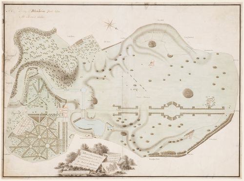
- DR1985:0416 records, in the form of a measured survey, the state of Blenheim Park in 1763, i.e., immediately before the modifications made by Capability Brown. According to this survey, the components and the layout of the park at that date corresponded closely to the original design (1705-16) published in `Vitruvius Britannicus III' (1725), pls. 72-73: the Grand Bridge, the kitchen garden, the tree-lined rides, the Grand Avenue, and the park plantations appear pretty much as their designers intended. However, DR1985:0416 also indicates that the military or state garden at the rear of the palace, with its great parterre and bastioned walls, was already more than half destroyed, and that a lake and a canal system comprised of three arms then existed at the front and to the south-east side of the palace. These important features, the histories of which are poorly documented, were entirely suppressed in the course of Brown's alterations.
DR1985:0416
Description:
- DR1985:0416 records, in the form of a measured survey, the state of Blenheim Park in 1763, i.e., immediately before the modifications made by Capability Brown. According to this survey, the components and the layout of the park at that date corresponded closely to the original design (1705-16) published in `Vitruvius Britannicus III' (1725), pls. 72-73: the Grand Bridge, the kitchen garden, the tree-lined rides, the Grand Avenue, and the park plantations appear pretty much as their designers intended. However, DR1985:0416 also indicates that the military or state garden at the rear of the palace, with its great parterre and bastioned walls, was already more than half destroyed, and that a lake and a canal system comprised of three arms then existed at the front and to the south-east side of the palace. These important features, the histories of which are poorly documented, were entirely suppressed in the course of Brown's alterations.
People:
Subject:
landscape architecture, topographic
landscape architecture, topographic
Date:
1763
1763
Title:
A survey plan of Blenheim Park
Actions:
DR1985:0416
Description:
- DR1985:0416 records, in the form of a measured survey, the state of Blenheim Park in 1763, i.e., immediately before the modifications made by Capability Brown. According to this survey, the components and the layout of the park at that date corresponded closely to the original design (1705-16) published in `Vitruvius Britannicus III' (1725), pls. 72-73: the Grand Bridge, the kitchen garden, the tree-lined rides, the Grand Avenue, and the park plantations appear pretty much as their designers intended. However, DR1985:0416 also indicates that the military or state garden at the rear of the palace, with its great parterre and bastioned walls, was already more than half destroyed, and that a lake and a canal system comprised of three arms then existed at the front and to the south-east side of the palace. These important features, the histories of which are poorly documented, were entirely suppressed in the course of Brown's alterations.
Form:
drawings
drawings
Date:
1763
1763
People:
Subject:
landscape architecture, topographic
landscape architecture, topographic
Form:
photographs
Quantity:
68 slide(s)
photographs
Quantity:
68 slide(s)
Title:
No title
No title
Actions:
Reference number:
PH1979:0629:001-068
Description:
- The group consists of mainly photomicrographs and architectural views of Southwell Minster, Southwell, Nottinghamshire, England; Ely Cathedral, Ely, Cambridgeshire, England; Cathédrale Saint-Etienne de Bourges, Bourges, France; Tintern Abbey, Monmouthshire, Wales; and Cathédrale d'Amiens, Amiens, France. There is also a view of a side of a brook and a view of a hedge, in addition to a few unidentified views. There are further views of the natural landscape of Cumbria, England, including Wastwater, Bough Fell, Lake Ullswater, lake of Derwent Water and Borrowdale. There are also views of Murat, France; St. Paul's Cathedral, London, Greater London, England; Château de Chambord, Chambord, Loir-et-Cher, France; Surrey, England; Saint-Trophime, Arles, France; Chartres, Eure-et-Loir, France; and Kelmscott Manor, Kelmscot, Oxfordshire, England.
People:
Date:
1883-1930
1883-1930
Title:
No title
Actions:
PH1979:0629:001-068
Description:
- The group consists of mainly photomicrographs and architectural views of Southwell Minster, Southwell, Nottinghamshire, England; Ely Cathedral, Ely, Cambridgeshire, England; Cathédrale Saint-Etienne de Bourges, Bourges, France; Tintern Abbey, Monmouthshire, Wales; and Cathédrale d'Amiens, Amiens, France. There is also a view of a side of a brook and a view of a hedge, in addition to a few unidentified views. There are further views of the natural landscape of Cumbria, England, including Wastwater, Bough Fell, Lake Ullswater, lake of Derwent Water and Borrowdale. There are also views of Murat, France; St. Paul's Cathedral, London, Greater London, England; Château de Chambord, Chambord, Loir-et-Cher, France; Surrey, England; Saint-Trophime, Arles, France; Chartres, Eure-et-Loir, France; and Kelmscott Manor, Kelmscot, Oxfordshire, England.
Form:
photographs
Quantity:
68 slide(s)
photographs
Quantity:
68 slide(s)
Date:
1883-1930
1883-1930
People:
Form:
textual records
textual records
Actions:
Reference number:
ARCH257223
Description:
"Permanent Files" - Lake Superior Centre, University of North Carolina Master Plan (Greensboro), University of British Columbia New Library Project, New Federal Court of Canada Building (Ottawa), Bayshore Gardens zoning admendment, Coal Harboor Arts Complex, Port Moody City Hall Library and Theatre Building, Furry Creek Development Project, Emily Carr College of Art and Design, Greater Victoria Hospital Diagnostic Treatment Facilities, Vancouver Dance Centre, University of British Columbia Performing Arts Facility, DCAD North Terminal Expansion (Miami)
People:
Date:
1990-1991
1990-1991
Title:
Permanent Files for various projects
Actions:
ARCH257223
Description:
"Permanent Files" - Lake Superior Centre, University of North Carolina Master Plan (Greensboro), University of British Columbia New Library Project, New Federal Court of Canada Building (Ottawa), Bayshore Gardens zoning admendment, Coal Harboor Arts Complex, Port Moody City Hall Library and Theatre Building, Furry Creek Development Project, Emily Carr College of Art and Design, Greater Victoria Hospital Diagnostic Treatment Facilities, Vancouver Dance Centre, University of British Columbia Performing Arts Facility, DCAD North Terminal Expansion (Miami)
Form:
textual records
textual records
Date:
1990-1991
1990-1991
People:
Form:
textual records
textual records
Actions:
Reference number:
ARCH260052
Description:
Proposals: X-Kalay Mini Village; Bank of Canada; Inventory off-street parking lots, Victoria; multi-purpose recreation complex, Greater Nanaimo; Chirimena, Venezuela, tourist development plan; Edmonton Civic Centre; Edmonton Station Area; Lake Louise village service centre; Maple Ridge development plan; Capilano College; Ministry of Foreign Affairs, Riyadh; New Westminster Courthouse; Pacific National Exhibition planning; Sawaber National Housing, Kuwait; Tumbler Ridge town planning; Vancouver Art Gallery (includes a magazine with an article about the gallery); Whistler Town Centre
People:
Date:
1971-1977
1971-1977
Title:
Proposals for various projects
Actions:
ARCH260052
Description:
Proposals: X-Kalay Mini Village; Bank of Canada; Inventory off-street parking lots, Victoria; multi-purpose recreation complex, Greater Nanaimo; Chirimena, Venezuela, tourist development plan; Edmonton Civic Centre; Edmonton Station Area; Lake Louise village service centre; Maple Ridge development plan; Capilano College; Ministry of Foreign Affairs, Riyadh; New Westminster Courthouse; Pacific National Exhibition planning; Sawaber National Housing, Kuwait; Tumbler Ridge town planning; Vancouver Art Gallery (includes a magazine with an article about the gallery); Whistler Town Centre
Form:
textual records
textual records
Date:
1971-1977
1971-1977
People:
Form:
books
books
Actions:
Holdings:
Description:
344 pages illustrations (some color), portraits, maps 29 cm
Description:
344 pages illustrations (some color), portraits, maps 29 cm
Author:
Subject:
Publication:
New York, Crown Publishers [©1963]
New York, Crown Publishers [©1963]
Title:
A pictorial history of the Great Lakes / by Harlan Hatcher and Erich A. Walter, assisted by Orin W. Kaye, Jr.
Actions:
Holdings:
Description:
344 pages illustrations (some color), portraits, maps 29 cm
A pictorial history of the Great Lakes / by Harlan Hatcher and Erich A. Walter, assisted by Orin W. Kaye, Jr.
Actions:
Holdings:
Description:
344 pages illustrations (some color), portraits, maps 29 cm
Form:
books
books
Publication:
New York, Crown Publishers [©1963]
New York, Crown Publishers [©1963]
Author:
Subject:
Form:
books
books
Holdings:
Description:
238 pages : illustrations, maps ; 21 cm
Description:
238 pages : illustrations, maps ; 21 cm
Author:
Subject:
Publication:
Ann Arbor : University of Michigan Press, 1985.
Ann Arbor : University of Michigan Press, 1985.
Title:
The Great Lakes guidebook : Lakes Ontario and Erie / George Cantor.
Actions:
Holdings:
Description:
238 pages : illustrations, maps ; 21 cm
The Great Lakes guidebook : Lakes Ontario and Erie / George Cantor.
Actions:
Holdings:
Description:
238 pages : illustrations, maps ; 21 cm
Form:
books
books
Publication:
Ann Arbor : University of Michigan Press, 1985.
Ann Arbor : University of Michigan Press, 1985.
Author:
Subject:
Form:
books
books
Actions:
Holdings:
Description:
167 pages : illustrations ; 26 cm
Description:
167 pages : illustrations ; 26 cm
Author:
Subject:
Publication:
Lansing, Mich. : Thunder Bay Press, ©1994.
Lansing, Mich. : Thunder Bay Press, ©1994.
Title:
Old forts of the Great Lakes : sentinels in the wilderness / James P. Barry.
Actions:
Holdings:
Description:
167 pages : illustrations ; 26 cm
Old forts of the Great Lakes : sentinels in the wilderness / James P. Barry.
Actions:
Holdings:
Description:
167 pages : illustrations ; 26 cm
Form:
books
books
Publication:
Lansing, Mich. : Thunder Bay Press, ©1994.
Lansing, Mich. : Thunder Bay Press, ©1994.
Author:
Subject:
Form:
books
books
Actions:
Holdings:
Description:
226 pages : illustrations, maps ; 21 cm
Description:
226 pages : illustrations, maps ; 21 cm
Author:
Subject:
Publication:
Ann Arbor : University of Michigan Press, ©1980.
Ann Arbor : University of Michigan Press, ©1980.
Title:
The Great Lakes guidebook : Lake Superior and western Lake Michigan / George Cantor.
Actions:
Holdings:
Description:
226 pages : illustrations, maps ; 21 cm
The Great Lakes guidebook : Lake Superior and western Lake Michigan / George Cantor.
Actions:
Holdings:
Description:
226 pages : illustrations, maps ; 21 cm
Form:
books
books
Publication:
Ann Arbor : University of Michigan Press, ©1980.
Ann Arbor : University of Michigan Press, ©1980.
Author:
Subject: