5705 Results
Form:
drawings
Quantity:
6 File
drawings
Quantity:
6 File
Actions:
Reference number:
ARCH257084
ARCH257084
People:
Date:
circa 1947-2002
circa 1947-2002
Form:
drawings
Quantity:
6 File
drawings
Quantity:
6 File
Date:
circa 1947-2002
circa 1947-2002
People:
Form:
textual records
textual records
Actions:
Reference number:
ARCH257686
ARCH257686
People:
Date:
circa 1947-2002
circa 1947-2002
Form:
textual records
textual records
Date:
circa 1947-2002
circa 1947-2002
People:
Form:
events
events
Actions:
Date:
14 July 2023, 2pm to 4pm (EST)
14 July 2023, 2pm to 4pm (EST)
Form:
events
events
Date:
14 July 2023
2pm to 4pm (EST)
14 July 2023
2pm to 4pm (EST)
Form:
events
events
Actions:
Description:
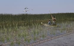
The St. Peter’s Indian Band (now Peguis First Nation) was forcibly removed from their original lands at Netley-Libau Marsh beginning in 1908, after an illegal surrender vote took place. Since then, the health of the area that was once the Peguis’s home has declined due to intense annual flooding and ice jams; the appearance of invasive species such as purple loosestrife,(...)
The St. Peter’s Indian Band (now Peguis First Nation) was forcibly removed from their original lands at Netley-Libau Marsh beginning in 1908, after an illegal surrender vote took place. Since then, the health of the area that was once the Peguis’s home has declined due to intense annual flooding and ice jams; the appearance of invasive species such as purple loosestrife,(...)
Location:
online Keyword(s):
Indigenous-led design, fellow, Peguis First Nation, land rehabilitation
online Keyword(s):
Indigenous-led design, fellow, Peguis First Nation, land rehabilitation
Date:
27 April 2023, 6:00 to 7:30 p.m.
27 April 2023, 6:00 to 7:30 p.m.
Title:
Peguis First Nation and the Netley-Libau Marsh: Documenting Indigenous Land Use and Occupancy at the Mouth of Lake Winnipeg
Actions:
Description:
The St. Peter’s Indian Band (now Peguis First Nation) was forcibly removed from their original lands at Netley-Libau Marsh beginning in 1908, after an illegal surrender vote took place. Since then, the health of the area that was once the Peguis’s home has declined due to intense annual flooding and ice jams; the appearance of invasive species such as purple loosestrife,(...)
Form:
events
events
Date:
27 April 2023
6:00 to 7:30 p.m.
27 April 2023
6:00 to 7:30 p.m.
Location:
online Keyword(s):
Indigenous-led design, fellow, Peguis First Nation, land rehabilitation
online Keyword(s):
Indigenous-led design, fellow, Peguis First Nation, land rehabilitation
Form:
drawings
drawings
Actions:
Reference number:
DR1983:0557
DR1983:0557
People:
Date:
1864
1864
Form:
drawings
drawings
Date:
1864
1864
People:
Form:
drawings
drawings
Actions:
Reference number:
AP206.S4.052
AP206.S4.052
People:
Date:
circa 1980s-2000s
circa 1980s-2000s
Form:
drawings
drawings
Date:
circa 1980s-2000s
circa 1980s-2000s
People:
Level of archival description:
Project
Project
Actions:
Reference number:
AP022.S1.1976.PR14
Description:
File documents site plan proposals for residences within the property lines of an extension to Beaumont Road, Toronto, Ontario. File contains survey drawings and design development drawings.
AP022.S1.1976.PR14
Description:
File documents site plan proposals for residences within the property lines of an extension to Beaumont Road, Toronto, Ontario. File contains survey drawings and design development drawings.
People:
Date:
1976-1977
1976-1977
Title:
Beaumont Road Land Severence Project
Actions:
AP022.S1.1976.PR14
Description:
File documents site plan proposals for residences within the property lines of an extension to Beaumont Road, Toronto, Ontario. File contains survey drawings and design development drawings.
Beaumont Road Land Severence Project
Actions:
AP022.S1.1976.PR14
Description:
File documents site plan proposals for residences within the property lines of an extension to Beaumont Road, Toronto, Ontario. File contains survey drawings and design development drawings.
Level of archival description:
Project
Project
Date:
1976-1977
1976-1977
People:
Form:
textual records
textual records
Actions:
Reference number:
ARCH254083
Description:
notes, working papers
ARCH254083
Description:
notes, working papers
People:
Date:
1977
1977
Form:
textual records
textual records
Date:
1977
1977
People:
Form:
textual records
textual records
Actions:
Reference number:
ARCH260409
ARCH260409
People:
Date:
circa 1985
circa 1985
Form:
textual records
textual records
Date:
circa 1985
circa 1985
People:
Form:
textual records
textual records
Reference number:
ARCH187492
ARCH187492
People:
Form:
textual records
textual records
People: