2699 Results
Form:
books
books
Title:
Old Japan : old & rare photographs : catalogue 34, cemmemorating 150 years of Japanese photography.
Old Japan : old & rare photographs : catalogue 34, cemmemorating 150 years of Japanese photography.
Actions:
Holdings:
Description:
86 pages : illustrations (some color) ; 30 cm.
Description:
86 pages : illustrations (some color) ; 30 cm.
Title:
Old Japan : old & rare photographs : catalogue 34, cemmemorating 150 years of Japanese photography.
Actions:
Holdings:
Description:
86 pages : illustrations (some color) ; 30 cm.
Old Japan : old & rare photographs : catalogue 34, cemmemorating 150 years of Japanese photography.
Actions:
Holdings:
Description:
86 pages : illustrations (some color) ; 30 cm.
Form:
books
books
Publication:
Purley, Surrey, U.K. : Old Japan, 2007.
Purley, Surrey, U.K. : Old Japan, 2007.
Form:
books
books
Actions:
Price:
$23.00
(available to order)
Summary:
The product of an international collective of artists, architects and writers who create collaborative projects and publications, this third edition of Surface Tension's Supplement series documents three years of artistic research, site-specific work and location-based practices in Curitiba, Brazil--providing an in-depth exploration of the city's economically marginal(...)
Title:
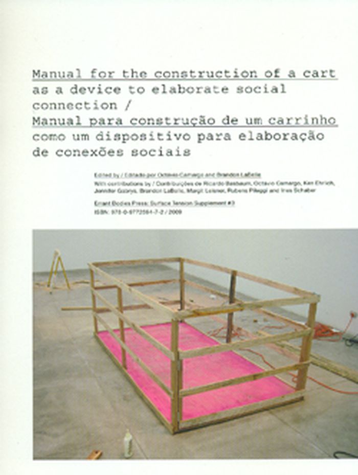
Surface Tension's Supplement 3 :Manual for the construction of a cart as a device to elaborate social connection
Actions:
Price:
$23.00
(available to order)
Summary:
The product of an international collective of artists, architects and writers who create collaborative projects and publications, this third edition of Surface Tension's Supplement series documents three years of artistic research, site-specific work and location-based practices in Curitiba, Brazil--providing an in-depth exploration of the city's economically marginal favela dwellers, who venture throughout the public spaces of Curitiba in search of recyclable materials. Documentation and texts elaborate on the cultural and political issues that come to light through various uses of public space. Originally developed as a collaborative installation between international and local artists--including Ken Ehrlich, Brandon LaBelle, Octávio Camargo and Guilherme Soares--exhibited at Curitiba's Ybakatu Gallery, this publication raises pertinent questions about the consequences of cross-cultural and site-specific collaboration and proffers an experimental approach toward political inquiry and intermedia practice.
Form:
books
books
Publication:
March 2009
March 2009
Form:
maps
maps
Actions:
Holdings:
Description:
1 map on 30 sheets : color ; sheets 34 x 31 cm
Description:
1 map on 30 sheets : color ; sheets 34 x 31 cm
Subject:
- Fire risk assessment Québec (Province) Montréal Maps.,
- Real property Québec (Province) Montréal Maps.,
- Assurance-incendie Québec (Province) Montréal Plans.,
- Plans cadastraux Québec (Province) Montréal.,
- Assurance-incendie Québec (Province) Montréal Cartes.,
- Fire risk assessment.,
- Real property.,
- Montréal (Québec) Maps.,
- Arrondissement Villeray/Saint Michel (Montréal, Québec) Maps.,
- Montréal (Québec) Plans.,
- Arrondissement Villeray/Saint Michel (Montréal, Québec) Plans.,
- Québec Montréal.,
- Fire insurance maps.,
- Maps.
(See more)
Publication:
Toronto : Canadian Underwriters' Association, [1952-1964]
Toronto : Canadian Underwriters' Association, [1952-1964]
Title:
Insurance plan of the city of Montréal. Volume 11 : plan dated April 1952, partially revised 1959, 1964.
Actions:
Holdings:
Description:
1 map on 30 sheets : color ; sheets 34 x 31 cm
Insurance plan of the city of Montréal. Volume 11 : plan dated April 1952, partially revised 1959, 1964.
Actions:
Holdings:
Description:
1 map on 30 sheets : color ; sheets 34 x 31 cm
Form:
maps
maps
Publication:
Toronto : Canadian Underwriters' Association, [1952-1964]
Toronto : Canadian Underwriters' Association, [1952-1964]
Subject:
- Fire risk assessment Québec (Province) Montréal Maps.,
- Real property Québec (Province) Montréal Maps.,
- Assurance-incendie Québec (Province) Montréal Plans.,
- Plans cadastraux Québec (Province) Montréal.,
- Assurance-incendie Québec (Province) Montréal Cartes.,
- Fire risk assessment.,
- Real property.,
- Montréal (Québec) Maps.,
- Arrondissement Villeray/Saint Michel (Montréal, Québec) Maps.,
- Montréal (Québec) Plans.,
- Arrondissement Villeray/Saint Michel (Montréal, Québec) Plans.,
- Québec Montréal.,
- Fire insurance maps.,
- Maps.
(See more)
Form:
maps
maps
Actions:
Holdings:
Description:
5 maps : color ; 69 x 80 cm folded to 23 x 16 cm
Description:
5 maps : color ; 69 x 80 cm folded to 23 x 16 cm
Subject:
- City planning Québec (Province) Montréal Maps.,
- Central business districts Québec (Province) Montréal Maps.,
- Zoning Québec (Province) Montréal Maps.,
- Zonage Québec (Province) Montréal Cartes.,
- Central business districts.,
- City planning.,
- Zoning.,
- Québec Montréal.,
- Urban planning Canada Québec (Province) Montréal 1990-2000.,
- Central business districts Canada Québec (Province) Montréal 1990-2000.,
- Zoning Canada Québec (Province) Montréal 1990-2000.,
- Master plans Canada Québec (Province) Montréal 1990-2000.,
- Maps.,
- Zoning maps.
(See more)
Publication:
Montréal : Ville de Montréal, Bureau du plan d'urbanisme, 1990.
Montréal : Ville de Montréal, Bureau du plan d'urbanisme, 1990.
Title:
Plan directeur d'aménagement et de développement de l'arrondissement Ville-Marie / Ville de Montréal, Service de l'habitation et du développement urbain, Bureau du plan d'urbanisme.
Actions:
Holdings:
Description:
5 maps : color ; 69 x 80 cm folded to 23 x 16 cm
Plan directeur d'aménagement et de développement de l'arrondissement Ville-Marie / Ville de Montréal, Service de l'habitation et du développement urbain, Bureau du plan d'urbanisme.
Actions:
Holdings:
Description:
5 maps : color ; 69 x 80 cm folded to 23 x 16 cm
Form:
maps
maps
Publication:
Montréal : Ville de Montréal, Bureau du plan d'urbanisme, 1990.
Montréal : Ville de Montréal, Bureau du plan d'urbanisme, 1990.
Subject:
- City planning Québec (Province) Montréal Maps.,
- Central business districts Québec (Province) Montréal Maps.,
- Zoning Québec (Province) Montréal Maps.,
- Zonage Québec (Province) Montréal Cartes.,
- Central business districts.,
- City planning.,
- Zoning.,
- Québec Montréal.,
- Urban planning Canada Québec (Province) Montréal 1990-2000.,
- Central business districts Canada Québec (Province) Montréal 1990-2000.,
- Zoning Canada Québec (Province) Montréal 1990-2000.,
- Master plans Canada Québec (Province) Montréal 1990-2000.,
- Maps.,
- Zoning maps.
(See more)
Form:
maps
maps
Actions:
Holdings:
Description:
1 map on 12 sheets : color ; sheets 65 x 55 cm
Description:
1 map on 12 sheets : color ; sheets 65 x 55 cm
Subject:
- Fire risk assessment Ontario Arnprior Maps.,
- Fire risk assessment Ontario McNab Maps.,
- Real property Ontario Arnprior Maps.,
- Real property Ontario McNab Maps.,
- Assurance-incendie Ontario Arnprior Plans.,
- Assurance-incendie Ontario McNab Plans.,
- Plans cadastraux Ontario Arnprior.,
- Plans cadastraux Ontario McNab.,
- Assurance-incendie Ontario Arnprior Cartes.,
- Fire risk assessment.,
- Real property.,
- Arnprior (Ont.) Maps.,
- McNab (Ont.) Maps.,
- Arnprior (Ont.) Plans.,
- McNab (Ont.) Plans.,
- Ontario Arnprior.,
- Fire insurance maps.,
- Maps.
(See more)
Publication:
Toronto : Underwriters' Survey Bureau, [1950]
Toronto : Underwriters' Survey Bureau, [1950]
Title:
Insurance plan of the town of Arnprior, Ont., population 4,100 : plan dated January, 1950.
Actions:
Holdings:
Description:
1 map on 12 sheets : color ; sheets 65 x 55 cm
Insurance plan of the town of Arnprior, Ont., population 4,100 : plan dated January, 1950.
Actions:
Holdings:
Description:
1 map on 12 sheets : color ; sheets 65 x 55 cm
Form:
maps
maps
Publication:
Toronto : Underwriters' Survey Bureau, [1950]
Toronto : Underwriters' Survey Bureau, [1950]
Subject:
- Fire risk assessment Ontario Arnprior Maps.,
- Fire risk assessment Ontario McNab Maps.,
- Real property Ontario Arnprior Maps.,
- Real property Ontario McNab Maps.,
- Assurance-incendie Ontario Arnprior Plans.,
- Assurance-incendie Ontario McNab Plans.,
- Plans cadastraux Ontario Arnprior.,
- Plans cadastraux Ontario McNab.,
- Assurance-incendie Ontario Arnprior Cartes.,
- Fire risk assessment.,
- Real property.,
- Arnprior (Ont.) Maps.,
- McNab (Ont.) Maps.,
- Arnprior (Ont.) Plans.,
- McNab (Ont.) Plans.,
- Ontario Arnprior.,
- Fire insurance maps.,
- Maps.
(See more)
Form:
books
books
Actions:
Holdings:
Description:
3 volumes : plans, portrait ; 26 cm
- Library main 138600 | W13099; ID:86-B9476 | v. 1 | Available
- Library main 138599 | W13099; ID:86-B9476 | v. 2 | Available
- Library main 138598 | W13099; ID:86-B9476 | v. 3 | Available
(See more)
Description:
3 volumes : plans, portrait ; 26 cm
Subject:
- City planning France Paris History.,
- City planning France History.,
- Real property France Paris.,
- Biens réels France Paris.,
- Buildings,
- City planning,
- Real property,
- Travel,
- Paris (France) History.,
- Paris (France) Description and travel.,
- Paris (France) Maps.,
- Paris (France) Buildings, structures, etc.,
- Paris (France) Histoire.,
- Paris (France) Descriptions et voyages.,
- France,
- France Paris,
- History,
- Maps,
- Cartes géographiques.
(See more)
Publication:
Paris : [publisher not identified], 1929-1931., Nogent-le-Rotrou : Imprimerie Daupeley-Gouverneur, [1929]-1931.
Paris : [publisher not identified], 1929-1931., Nogent-le-Rotrou : Imprimerie Daupeley-Gouverneur, [1929]-1931.
Title:
Études de topographie parisienne / par Maurice Dumolin.
Actions:
Holdings:
Description:
3 volumes : plans, portrait ; 26 cm
Études de topographie parisienne / par Maurice Dumolin.
Actions:
Holdings:
- Library main 138600 | W13099; ID:86-B9476 | v. 1 | Available
- Library main 138599 | W13099; ID:86-B9476 | v. 2 | Available
- Library main 138598 | W13099; ID:86-B9476 | v. 3 | Available
(See more)
Description:
3 volumes : plans, portrait ; 26 cm
Form:
books
books
Publication:
Paris : [publisher not identified], 1929-1931., Nogent-le-Rotrou : Imprimerie Daupeley-Gouverneur, [1929]-1931.
Paris : [publisher not identified], 1929-1931., Nogent-le-Rotrou : Imprimerie Daupeley-Gouverneur, [1929]-1931.
Subject:
- City planning France Paris History.,
- City planning France History.,
- Real property France Paris.,
- Biens réels France Paris.,
- Buildings,
- City planning,
- Real property,
- Travel,
- Paris (France) History.,
- Paris (France) Description and travel.,
- Paris (France) Maps.,
- Paris (France) Buildings, structures, etc.,
- Paris (France) Histoire.,
- Paris (France) Descriptions et voyages.,
- France,
- France Paris,
- History,
- Maps,
- Cartes géographiques.
(See more)
Form:
books
books
Holdings:
Description:
vii, 199 pages : illustrations (chiefly color), maps (chiefly color) ; 29 cm
Description:
vii, 199 pages : illustrations (chiefly color), maps (chiefly color) ; 29 cm
Subject:
Publication:
Chicago : The University of Chicago Press, 2020., ©2020
Chicago : The University of Chicago Press, 2020., ©2020
Title:
The Eternal City : a history of Rome in maps / Jessica Maier.
Actions:
Holdings:
Description:
vii, 199 pages : illustrations (chiefly color), maps (chiefly color) ; 29 cm
The Eternal City : a history of Rome in maps / Jessica Maier.
Actions:
Holdings:
Description:
vii, 199 pages : illustrations (chiefly color), maps (chiefly color) ; 29 cm
Form:
books
books
Publication:
Chicago : The University of Chicago Press, 2020., ©2020
Chicago : The University of Chicago Press, 2020., ©2020
Form:
books
books
Actions:
Holdings:
Description:
128 pages : illustrations ; 26 cm
Description:
128 pages : illustrations ; 26 cm
Subject:
- Bush-Brown, Harold.,
- Bush-Brown, Harold, 1888-,
- Bush-Brown, Harold, (1888-1983),
- Architects United States Biography.,
- Architecture, Modern 20th century.,
- Architects United States.,
- Architecture, Modern.,
- Architectes États-Unis.,
- Architectes États-Unis Biographies.,
- Architecture moderne 20e siècle.,
- Architecture 20e siècle.,
- Architects,
- United States,
- Carter, Harold,
- autobiographies (literary works),
- Autobiographies,
- Biographies
(See more)
Publication:
New York : Whitney Library of Design, 1976.
New York : Whitney Library of Design, 1976.
Title:
Beaux arts to Bauhaus and beyond : an architect's perspective / by Harold Bush-Brown.
Actions:
Holdings:
Description:
128 pages : illustrations ; 26 cm
Beaux arts to Bauhaus and beyond : an architect's perspective / by Harold Bush-Brown.
Actions:
Holdings:
Description:
128 pages : illustrations ; 26 cm
Form:
books
books
Publication:
New York : Whitney Library of Design, 1976.
New York : Whitney Library of Design, 1976.
Subject:
- Bush-Brown, Harold.,
- Bush-Brown, Harold, 1888-,
- Bush-Brown, Harold, (1888-1983),
- Architects United States Biography.,
- Architecture, Modern 20th century.,
- Architects United States.,
- Architecture, Modern.,
- Architectes États-Unis.,
- Architectes États-Unis Biographies.,
- Architecture moderne 20e siècle.,
- Architecture 20e siècle.,
- Architects,
- United States,
- Carter, Harold,
- autobiographies (literary works),
- Autobiographies,
- Biographies
(See more)
Form:
books
books
Actions:
Holdings:
Description:
xiv, 278 pages : illustrations (some color), maps (some color) ; 30 x 31 cm
Description:
xiv, 278 pages : illustrations (some color), maps (some color) ; 30 x 31 cm
Author:
Subject:
Publication:
Cambridge, Massachusetts : The MIT Press, ©1999.
Cambridge, Massachusetts : The MIT Press, ©1999.
Title:
Mapping Boston / edited by Alex Krieger and David Cobb with Amy Turner ; contributing essays by David Bosse, James Carroll, David Cobb, Alex Krieger, Barbara McCorkle Nancy S. Seasholes, Sam Bass Warner, Jr. ; vignettes accompanying the plates, Anne Mackin ; map descriptions, Nancy S. Seasholes and David Cobb.
Actions:
Holdings:
Description:
xiv, 278 pages : illustrations (some color), maps (some color) ; 30 x 31 cm
Form:
books
books
Publication:
Cambridge, Massachusetts : The MIT Press, ©1999.
Cambridge, Massachusetts : The MIT Press, ©1999.
Form:
maps
maps
Actions:
Holdings:
Description:
1 volume (loose-leaf) : color map ; 35 cm
Description:
1 volume (loose-leaf) : color map ; 35 cm
Subject:
- Fire risk assessment Québec (Province) Montréal Maps.,
- Real property Québec (Province) Montréal Maps.,
- Assurance-incendie Québec (Province) Montréal Plans.,
- Plans cadastraux Québec (Province) Montréal.,
- Assurance-incendie Québec (Province) Montréal Cartes.,
- Fire risk assessment.,
- Real property.,
- Montréal (Québec) Maps.,
- Arrondissement Ahuntsic/Cartierville (Montréal, Québec) Maps.,
- Montréal (Québec) Plans.,
- Arrondissement Ahuntsic/Cartierville (Montréal, Québec) Plans.,
- Québec Montréal.,
- Fire insurance maps.,
- Maps.
(See more)
Publication:
[Toronto] : [Underwriters' Survey Bureau], [1953-1961]
[Toronto] : [Underwriters' Survey Bureau], [1953-1961]
Title:
Insurance plan of the city of Montréal. Volume 14 : plan dated September 1953.
Actions:
Holdings:
Description:
1 volume (loose-leaf) : color map ; 35 cm
Insurance plan of the city of Montréal. Volume 14 : plan dated September 1953.
Actions:
Holdings:
Description:
1 volume (loose-leaf) : color map ; 35 cm
Form:
maps
maps
Publication:
[Toronto] : [Underwriters' Survey Bureau], [1953-1961]
[Toronto] : [Underwriters' Survey Bureau], [1953-1961]
Subject:
- Fire risk assessment Québec (Province) Montréal Maps.,
- Real property Québec (Province) Montréal Maps.,
- Assurance-incendie Québec (Province) Montréal Plans.,
- Plans cadastraux Québec (Province) Montréal.,
- Assurance-incendie Québec (Province) Montréal Cartes.,
- Fire risk assessment.,
- Real property.,
- Montréal (Québec) Maps.,
- Arrondissement Ahuntsic/Cartierville (Montréal, Québec) Maps.,
- Montréal (Québec) Plans.,
- Arrondissement Ahuntsic/Cartierville (Montréal, Québec) Plans.,
- Québec Montréal.,
- Fire insurance maps.,
- Maps.
(See more)