5646 Results
Form:
events
events

Actions:
Description:
Rooted in acts of reciprocity and land-based knowledge teachings, the work of Brooke Rice, Autumn Godwin, Marnie Jacobs, and Amanda Lickers resists erasure by honouring natural cycles and fostering continuity between past, present, and future.
Rooted in acts of reciprocity and land-based knowledge teachings, the work of Brooke Rice, Autumn Godwin, Marnie Jacobs, and Amanda Lickers resists erasure by honouring natural cycles and fostering continuity between past, present, and future.
Date:
13 November 2025, 6pm to 7:30pm
13 November 2025, 6pm to 7:30pm
Title:
Placekeeping with Brooke Rice, Autumn Godwin, Marnie Jacobs, and Amanda Lickers
Actions:
Description:
Rooted in acts of reciprocity and land-based knowledge teachings, the work of Brooke Rice, Autumn Godwin, Marnie Jacobs, and Amanda Lickers resists erasure by honouring natural cycles and fostering continuity between past, present, and future.
Form:
events
events
Date:
13 November 2025
6pm to 7:30pm
13 November 2025
6pm to 7:30pm
Form:
drawings
drawings
Actions:
Reference number:
DR1987:0462
Description:
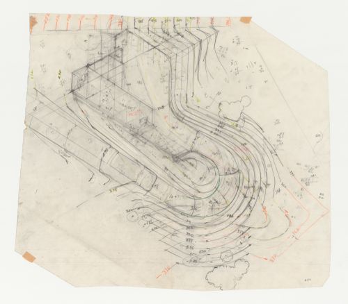
- This partial site plan for Swedenborg Memorial Chapel, El Cerrito, California, indicates the grading for the road and land surrounding the chapel.
DR1987:0462
Description:
- This partial site plan for Swedenborg Memorial Chapel, El Cerrito, California, indicates the grading for the road and land surrounding the chapel.
People:
Subject:
architecture
architecture
Date:
between 1955 and 1962
between 1955 and 1962
Title:
Swedenborg Memorial Chapel, El Cerrito, California: Grading plan for the chapel
Actions:
DR1987:0462
Description:
- This partial site plan for Swedenborg Memorial Chapel, El Cerrito, California, indicates the grading for the road and land surrounding the chapel.
Swedenborg Memorial Chapel, El Cerrito, California: Grading plan for the chapel
Actions:
DR1987:0462
Description:
- This partial site plan for Swedenborg Memorial Chapel, El Cerrito, California, indicates the grading for the road and land surrounding the chapel.
Form:
drawings
drawings
Date:
between 1955 and 1962
between 1955 and 1962
People:
Subject:
architecture
architecture
Form:
textual records
textual records
Actions:
Reference number:
AP046.S1.1983.PR01.540
Description:
This box consists of Consultants documents including minutes, correspondence, reports, and sketches for: elevators, security, project planner, land surveyor, and traffic.
AP046.S1.1983.PR01.540
Description:
This box consists of Consultants documents including minutes, correspondence, reports, and sketches for: elevators, security, project planner, land surveyor, and traffic.
People:
Date:
1985-1989
1985-1989
Title:
Consultants documents, Canadian Centre for Architecture, Montréal, Québec
Actions:
AP046.S1.1983.PR01.540
Description:
This box consists of Consultants documents including minutes, correspondence, reports, and sketches for: elevators, security, project planner, land surveyor, and traffic.
Consultants documents, Canadian Centre for Architecture, Montréal, Québec
Actions:
AP046.S1.1983.PR01.540
Description:
This box consists of Consultants documents including minutes, correspondence, reports, and sketches for: elevators, security, project planner, land surveyor, and traffic.
Form:
textual records
textual records
Date:
1985-1989
1985-1989
People:
Form:
textual records
textual records
Title:
Publications on Chandigarh
Publications on Chandigarh
Actions:
Reference number:
AP206.S4.090
Description:
This file consists of Tomorrow Land booklet, Punjab and Haryana High Court Golden Jubilee booklet and unidentified booklet on Chandigarh in Hindi.
AP206.S4.090
Description:
This file consists of Tomorrow Land booklet, Punjab and Haryana High Court Golden Jubilee booklet and unidentified booklet on Chandigarh in Hindi.
People:
Date:
2004-2008
2004-2008
Title:
Publications on Chandigarh
Actions:
AP206.S4.090
Description:
This file consists of Tomorrow Land booklet, Punjab and Haryana High Court Golden Jubilee booklet and unidentified booklet on Chandigarh in Hindi.
Publications on Chandigarh
Actions:
AP206.S4.090
Description:
This file consists of Tomorrow Land booklet, Punjab and Haryana High Court Golden Jubilee booklet and unidentified booklet on Chandigarh in Hindi.
Form:
textual records
textual records
Date:
2004-2008
2004-2008
People:
Level of archival description:
Project
Project
Actions:
Reference number:
AP075.S1.1990.PR11
Description:
Project series documents Cornelia Hahn Oberlander's landscape project for Feigl Residence, located on Drummond Drive, in the University Endowment Land, in Vancouver, British Columbia. Oberlander worked on this project in the early 1990s. Oberlander's project for the Feigl residence consisted in redesigning the garden initally executed in the late 1950s by Justice & Webb Landscape Architects. She later returned in 2007-2008 for the design and the planting of an "green shield" of trees to improve to view from the residence and block the noises from the neighbouring developments. The project series contains only nine drawing, including preliminary grading plans, site plans, and land surveys used as reference.The project series also comprises textual records, including concept notes by Oberlander, correspondence with client and contractors, photographs of the existing landscaping, and cost estimates. The 2007-2008 addition is documented through a series of sketches of the view on the garden from the house, correspondence with contractors and client.
People:
Date:
1978-2008
1978-2008
Title:
Feigl Residence, Vancouver, British Columbia (1990-1991)
Actions:
AP075.S1.1990.PR11
Description:
Project series documents Cornelia Hahn Oberlander's landscape project for Feigl Residence, located on Drummond Drive, in the University Endowment Land, in Vancouver, British Columbia. Oberlander worked on this project in the early 1990s. Oberlander's project for the Feigl residence consisted in redesigning the garden initally executed in the late 1950s by Justice & Webb Landscape Architects. She later returned in 2007-2008 for the design and the planting of an "green shield" of trees to improve to view from the residence and block the noises from the neighbouring developments. The project series contains only nine drawing, including preliminary grading plans, site plans, and land surveys used as reference.The project series also comprises textual records, including concept notes by Oberlander, correspondence with client and contractors, photographs of the existing landscaping, and cost estimates. The 2007-2008 addition is documented through a series of sketches of the view on the garden from the house, correspondence with contractors and client.
Level of archival description:
Project
Project
Date:
1978-2008
1978-2008
People:
Form:
drawings
Quantity:
25 reprographic copy(ies)
drawings
Quantity:
25 reprographic copy(ies)
Actions:
Reference number:
DR1995:0255:154
Description:
ordnance maps showing sketch proposals, schematic plans, sketch sections, plans, diagrammatic plans showing land use and development phases, and layout plan
DR1995:0255:154
Description:
ordnance maps showing sketch proposals, schematic plans, sketch sections, plans, diagrammatic plans showing land use and development phases, and layout plan
People:
Title:
Ordnance maps showing sketch proposals, schematic plans
Actions:
DR1995:0255:154
Description:
ordnance maps showing sketch proposals, schematic plans, sketch sections, plans, diagrammatic plans showing land use and development phases, and layout plan
Ordnance maps showing sketch proposals, schematic plans
Actions:
DR1995:0255:154
Description:
ordnance maps showing sketch proposals, schematic plans, sketch sections, plans, diagrammatic plans showing land use and development phases, and layout plan
Form:
drawings
Quantity:
25 reprographic copy(ies)
drawings
Quantity:
25 reprographic copy(ies)
People:
Form:
drawings
Quantity:
25 reprographic copy(ies)
drawings
Quantity:
25 reprographic copy(ies)
Actions:
Reference number:
DR1995:0255:155
Description:
ordnance maps showing sketch proposals, schematic plans, sketch sections, plans, diagrammatic plans showing land use and development phases, and layout plan
DR1995:0255:155
Description:
ordnance maps showing sketch proposals, schematic plans, sketch sections, plans, diagrammatic plans showing land use and development phases, and layout plan
People:
Title:
Ordnance maps showing sketch proposals, schematic plans
Actions:
DR1995:0255:155
Description:
ordnance maps showing sketch proposals, schematic plans, sketch sections, plans, diagrammatic plans showing land use and development phases, and layout plan
Ordnance maps showing sketch proposals, schematic plans
Actions:
DR1995:0255:155
Description:
ordnance maps showing sketch proposals, schematic plans, sketch sections, plans, diagrammatic plans showing land use and development phases, and layout plan
Form:
drawings
Quantity:
25 reprographic copy(ies)
drawings
Quantity:
25 reprographic copy(ies)
People:
Form:
drawings
Quantity:
25 reprographic copy(ies)
drawings
Quantity:
25 reprographic copy(ies)
Actions:
Reference number:
DR1995:0255:156
Description:
ordnance maps showing sketch proposals, schematic plans, sketch sections, plans, diagrammatic plans showing land use and development phases, and layout plan
DR1995:0255:156
Description:
ordnance maps showing sketch proposals, schematic plans, sketch sections, plans, diagrammatic plans showing land use and development phases, and layout plan
People:
Title:
Ordnance maps showing sketch proposals, schematic plans
Actions:
DR1995:0255:156
Description:
ordnance maps showing sketch proposals, schematic plans, sketch sections, plans, diagrammatic plans showing land use and development phases, and layout plan
Ordnance maps showing sketch proposals, schematic plans
Actions:
DR1995:0255:156
Description:
ordnance maps showing sketch proposals, schematic plans, sketch sections, plans, diagrammatic plans showing land use and development phases, and layout plan
Form:
drawings
Quantity:
25 reprographic copy(ies)
drawings
Quantity:
25 reprographic copy(ies)
People:
Form:
drawings
Quantity:
25 reprographic copy(ies)
drawings
Quantity:
25 reprographic copy(ies)
Actions:
Reference number:
DR1995:0255:157
Description:
ordnance maps showing sketch proposals, schematic plans, sketch sections, plans, diagrammatic plans showing land use and development phases, and layout plan
DR1995:0255:157
Description:
ordnance maps showing sketch proposals, schematic plans, sketch sections, plans, diagrammatic plans showing land use and development phases, and layout plan
People:
Title:
Ordnance maps showing sketch proposals, schematic plans
Actions:
DR1995:0255:157
Description:
ordnance maps showing sketch proposals, schematic plans, sketch sections, plans, diagrammatic plans showing land use and development phases, and layout plan
Ordnance maps showing sketch proposals, schematic plans
Actions:
DR1995:0255:157
Description:
ordnance maps showing sketch proposals, schematic plans, sketch sections, plans, diagrammatic plans showing land use and development phases, and layout plan
Form:
drawings
Quantity:
25 reprographic copy(ies)
drawings
Quantity:
25 reprographic copy(ies)
People:
Form:
drawings
Quantity:
25 reprographic copy(ies)
drawings
Quantity:
25 reprographic copy(ies)
Actions:
Reference number:
DR1995:0255:158
Description:
ordnance maps showing sketch proposals, schematic plans, sketch sections, plans, diagrammatic plans showing land use and development phases, and layout plan
DR1995:0255:158
Description:
ordnance maps showing sketch proposals, schematic plans, sketch sections, plans, diagrammatic plans showing land use and development phases, and layout plan
People:
Title:
Ordnance maps showing sketch proposals, schematic plans
Actions:
DR1995:0255:158
Description:
ordnance maps showing sketch proposals, schematic plans, sketch sections, plans, diagrammatic plans showing land use and development phases, and layout plan
Ordnance maps showing sketch proposals, schematic plans
Actions:
DR1995:0255:158
Description:
ordnance maps showing sketch proposals, schematic plans, sketch sections, plans, diagrammatic plans showing land use and development phases, and layout plan
Form:
drawings
Quantity:
25 reprographic copy(ies)
drawings
Quantity:
25 reprographic copy(ies)
People: