34950 Results
Form:
maps, drawings
maps, drawings
Actions:
Reference number:
DR2004:0983:001
DR2004:0983:001
People:
Date:
1992
1992
Form:
maps, drawings
maps, drawings
Date:
1992
1992
People:
Form:
drawings
drawings

Actions:
Reference number:
DR1995:0255:091
DR1995:0255:091
People:
Date:
between 1971 and 1974?
between 1971 and 1974?
Form:
drawings
drawings
Date:
between 1971 and 1974?
between 1971 and 1974?
People:
Form:
maps, textual records
maps, textual records
Actions:
Reference number:
DR1994:0134:779
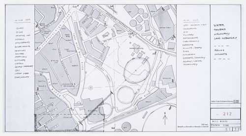
Description:
Situation plan
DR1994:0134:779
Description:
Situation plan
People:
Date:
1971-1989
1971-1989
Title:
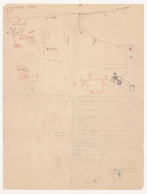
Sketch site map and notes for House VI, Cornwall, Connecticut
Actions:
DR1994:0134:779
Description:
Situation plan
Sketch site map and notes for House VI, Cornwall, Connecticut
Actions:
DR1994:0134:779
Description:
Situation plan
Form:
maps, textual records
maps, textual records
Date:
1971-1989
1971-1989
People:
Form:
drawings
Quantity:
35 design development drawing(s)
drawings
Quantity:
35 design development drawing(s)
Actions:
Reference number:
ARCH252856
ARCH252856
People:
Form:
drawings
Quantity:
35 design development drawing(s)
drawings
Quantity:
35 design development drawing(s)
People:
Form:
maps
maps
Actions:
Reference number:
DR2004:1177
DR2004:1177
People:
Form:
maps
maps
People:
Form:
drawings
Quantity:
3 File
drawings
Quantity:
3 File
Actions:
Reference number:
ARCH44334
ARCH44334
People:
Form:
drawings
Quantity:
3 File
drawings
Quantity:
3 File
People:
Form:
drawings
Quantity:
6 File
drawings
Quantity:
6 File
Actions:
Reference number:
ARCH257642
ARCH257642
People:
Date:
circa 1947-2002
circa 1947-2002
Form:
drawings
Quantity:
6 File
drawings
Quantity:
6 File
Date:
circa 1947-2002
circa 1947-2002
People:
Form:
drawings
drawings
Actions:
Reference number:
ARCH260575
ARCH260575
People:
Date:
circa 1982
circa 1982
Form:
drawings
drawings
Date:
circa 1982
circa 1982
People:
Form:
drawings
Quantity:
20 design development drawing(s)
drawings
Quantity:
20 design development drawing(s)
Reference number:
DR1995:0280:269-288
Description:
site plans, diagrammatic map, shadow studies, plans and axonometric views of cubes, diagram, interior layout plan, plans, sections, map, axonometric diagrams, and table
DR1995:0280:269-288
Description:
site plans, diagrammatic map, shadow studies, plans and axonometric views of cubes, diagram, interior layout plan, plans, sections, map, axonometric diagrams, and table
People:
Title:
Site plans, diagrammatic map, shadow studies, plans and axonometric views of cubes
Actions:
DR1995:0280:269-288
Description:
site plans, diagrammatic map, shadow studies, plans and axonometric views of cubes, diagram, interior layout plan, plans, sections, map, axonometric diagrams, and table
Site plans, diagrammatic map, shadow studies, plans and axonometric views of cubes
Actions:
DR1995:0280:269-288
Description:
site plans, diagrammatic map, shadow studies, plans and axonometric views of cubes, diagram, interior layout plan, plans, sections, map, axonometric diagrams, and table
Form:
drawings
Quantity:
20 design development drawing(s)
drawings
Quantity:
20 design development drawing(s)
People:
Form:
drawings
Quantity:
19 reprographic copy(ies)
drawings
Quantity:
19 reprographic copy(ies)
Actions:
Reference number:
ARCH267305
Description:
This group consists of plans of the development scheme and a topographic map of Île St-Paul (present-day Île-des-Sœurs) in Verdun, Québec. There are also floor plans of the Île-des-Sœurs apartment types.
ARCH267305
Description:
This group consists of plans of the development scheme and a topographic map of Île St-Paul (present-day Île-des-Sœurs) in Verdun, Québec. There are also floor plans of the Île-des-Sœurs apartment types.
People:
Title:
Plans of the development scheme and a topographic map of Île St-Paul
Actions:
ARCH267305
Description:
This group consists of plans of the development scheme and a topographic map of Île St-Paul (present-day Île-des-Sœurs) in Verdun, Québec. There are also floor plans of the Île-des-Sœurs apartment types.
Form:
drawings
Quantity:
19 reprographic copy(ies)
drawings
Quantity:
19 reprographic copy(ies)
People: