1502 Results
Form:
drawings
drawings
Actions:
Reference number:
DR1988:0435
Description:
- Plan of proposed fortifications for Sas van Gent, a lock on the Terneuzen-Ghent canal, where the canal meets the Wester Schelde River. The relationship between canal, lock, and river is not immediately clear in this drawing, but can be understood by comparison with A. Hattinga's map of 1750, 'Plan van het Sas van Gent' (Hattinga, reprint 1977). The dotted lines probably outline existing fortifications, while pentimenti in pen and red ink may be changes in the project (Cazort, 3.). There is a compass rose in the lower left corner.
People:
Subject:
military
military
Date:
1681
1681
Title:
Plan for new fortifications for the lock at Sas van Gent, United Netherlands
Actions:
DR1988:0435
Description:
- Plan of proposed fortifications for Sas van Gent, a lock on the Terneuzen-Ghent canal, where the canal meets the Wester Schelde River. The relationship between canal, lock, and river is not immediately clear in this drawing, but can be understood by comparison with A. Hattinga's map of 1750, 'Plan van het Sas van Gent' (Hattinga, reprint 1977). The dotted lines probably outline existing fortifications, while pentimenti in pen and red ink may be changes in the project (Cazort, 3.). There is a compass rose in the lower left corner.
Form:
drawings
drawings
Date:
1681
1681
People:
Subject:
military
military
Form:
photographs
photographs
Actions:
Reference number:
PH1985:0427:064
PH1985:0427:064
People:
Subject:
architecture, military
architecture, military
Date:
before 1877
before 1877
Title:
View of fortifications, probably part of the Tawila tanks, Aden, Yemen
Actions:
PH1985:0427:064
View of fortifications, probably part of the Tawila tanks, Aden, Yemen
Actions:
PH1985:0427:064
Form:
photographs
photographs
Date:
before 1877
before 1877
People:
Subject:
architecture, military
architecture, military
Form:
maps, works of art
maps, works of art
Actions:
Reference number:
DR1974:0002:030:010:001-003
DR1974:0002:030:010:001-003
People:
Subject:
architecture, engineering, military, topographic
architecture, engineering, military, topographic
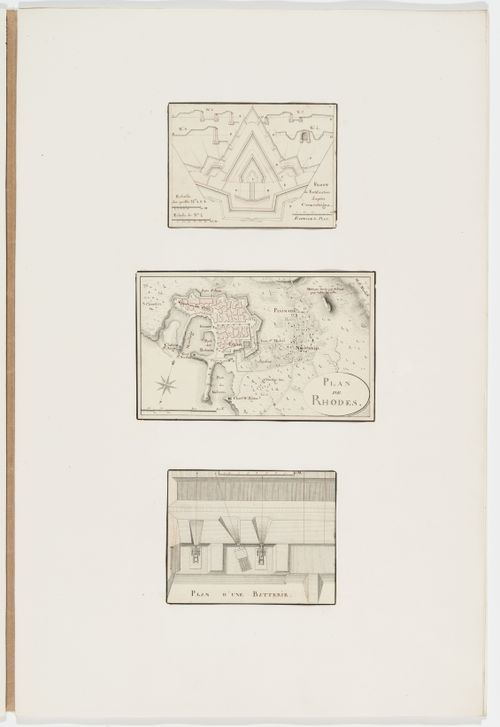
Date:
between 1800 and 1846
between 1800 and 1846
Title:
Partial plan and sections of fortifications; Map of Rhodes; Plan of a battery
Actions:
DR1974:0002:030:010:001-003
Partial plan and sections of fortifications; Map of Rhodes; Plan of a battery
Actions:
DR1974:0002:030:010:001-003
Form:
maps, works of art
maps, works of art
Date:
between 1800 and 1846
between 1800 and 1846
People:
Subject:
architecture, engineering, military, topographic
architecture, engineering, military, topographic
Form:
photographs
photographs
Actions:
Reference number:
PH1979:0447.04:043
PH1979:0447.04:043
People:
Subject:
architecture, military, topographic
architecture, military, topographic
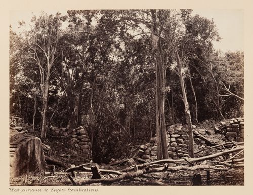
Date:
between 1860 and 1872
between 1860 and 1872
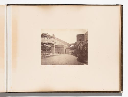
Title:
View of the west entrance to the fortifications, Sigiriya, Ceylon (now Sri Lanka)
Actions:
PH1979:0447.04:043
View of the west entrance to the fortifications, Sigiriya, Ceylon (now Sri Lanka)
Actions:
PH1979:0447.04:043
Form:
photographs
photographs
Date:
between 1860 and 1872
between 1860 and 1872
People:
Subject:
architecture, military, topographic
architecture, military, topographic
Form:
photographs
photographs
Actions:
Reference number:
PH1980:0048.01:003
PH1980:0048.01:003
People:
Subject:
architecture, military
architecture, military
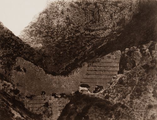
Date:
1859-1860
1859-1860
Title:
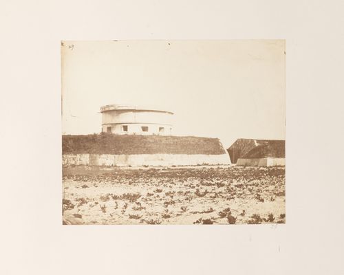
View of the ruins of the fortifications of Antioch, Ottoman Empire (now in Antakya, Turkey)
Actions:
PH1980:0048.01:003
View of the ruins of the fortifications of Antioch, Ottoman Empire (now in Antakya, Turkey)
Actions:
PH1980:0048.01:003
Form:
photographs
photographs
Date:
1859-1860
1859-1860
People:
Subject:
architecture, military
architecture, military
Form:
photographs
photographs
Actions:
Reference number:
PH1981:0787:049
PH1981:0787:049
People:
Subject:
architecture, engineering, military, topographic
architecture, engineering, military, topographic
Date:
between 1863 and 1877
between 1863 and 1877
Title:
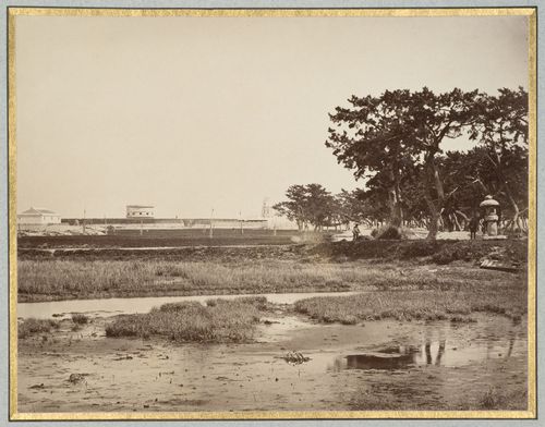
View of coastal fortifications showing a martello tower and a lighthouse, near Kobe, Japan
Actions:
PH1981:0787:049
View of coastal fortifications showing a martello tower and a lighthouse, near Kobe, Japan
Actions:
PH1981:0787:049
Form:
photographs
photographs
Date:
between 1863 and 1877
between 1863 and 1877
People:
Subject:
architecture, engineering, military, topographic
architecture, engineering, military, topographic
Form:
photographs
photographs
![View of Kaiserburg [?] tower with portion of medieval city fortifications in foreground, Nuremberg [?], Germany](/img-collection/oQVPuxBBSiicILzP8jqPbHj7ib8=/500x666/4629.jpg)
Actions:
Reference number:
PH1981:1048
PH1981:1048
People:
Form:
photographs
photographs
People:
Form:
photographs
photographs
Actions:
Reference number:
SV1981:0002:001
SV1981:0002:001
People:
Subject:
architecture, engineering, topographic
architecture, engineering, topographic
Date:
between 1860 and 1863
between 1860 and 1863
Title:
Stereograph of the Waghora River with city fortifications and a bridge in the background, Ajanta, India
Actions:
SV1981:0002:001
Stereograph of the Waghora River with city fortifications and a bridge in the background, Ajanta, India
Actions:
SV1981:0002:001
Form:
photographs
photographs
Date:
between 1860 and 1863
between 1860 and 1863
People:
Subject:
architecture, engineering, topographic
architecture, engineering, topographic
Form:
photographs
photographs
Title:
View of the Waghora River with city fortifications and a bridge in the background, Ajanta, India
View of the Waghora River with city fortifications and a bridge in the background, Ajanta, India
Actions:
Reference number:
PH1981:0202:002
PH1981:0202:002
People:
Subject:
architecture, engineering, topographic
architecture, engineering, topographic
Date:
between 1860 and 1863
between 1860 and 1863
Title:
View of the Waghora River with city fortifications and a bridge in the background, Ajanta, India
Actions:
PH1981:0202:002
View of the Waghora River with city fortifications and a bridge in the background, Ajanta, India
Actions:
PH1981:0202:002
Form:
photographs
photographs
Date:
between 1860 and 1863
between 1860 and 1863
People:
Subject:
architecture, engineering, topographic
architecture, engineering, topographic
Form:
photographs
photographs
Title:
View of coastal fortifications showing a martello tower and defensive walls, near Kobe, Japan
View of coastal fortifications showing a martello tower and defensive walls, near Kobe, Japan
Actions:
Reference number:
PH1981:0620:032
Description:
- A hand-written table of contents accompanies album PH1981:0620:001-081.
PH1981:0620:032
Description:
- A hand-written table of contents accompanies album PH1981:0620:001-081.
People:
Subject:
architecture, engineering, military, topographic
architecture, engineering, military, topographic
Date:
between 1863 and 1877
between 1863 and 1877
Title:
View of coastal fortifications showing a martello tower and defensive walls, near Kobe, Japan
Actions:
PH1981:0620:032
Description:
- A hand-written table of contents accompanies album PH1981:0620:001-081.
View of coastal fortifications showing a martello tower and defensive walls, near Kobe, Japan
Actions:
PH1981:0620:032
Description:
- A hand-written table of contents accompanies album PH1981:0620:001-081.
Form:
photographs
photographs
Date:
between 1863 and 1877
between 1863 and 1877
People:
Subject:
architecture, engineering, military, topographic
architecture, engineering, military, topographic