34822 Results
Form:
photographs
photographs
Title:
An aerial map of downtown Montréal, titled "Sherbrooke St. to Papineau St., Peel St. & The River"
An aerial map of downtown Montréal, titled "Sherbrooke St. to Papineau St., Peel St. & The River"
Actions:
Reference number:
DR2012:0012:046:034
Description:
An aerial map of downtown Montréal, titled "Sherbrooke St. to Papineau St., Peel St. & The River".
DR2012:0012:046:034
Description:
An aerial map of downtown Montréal, titled "Sherbrooke St. to Papineau St., Peel St. & The River".
People:
Date:
n.d.
n.d.
Title:
An aerial map of downtown Montréal, titled "Sherbrooke St. to Papineau St., Peel St. & The River"
Actions:
DR2012:0012:046:034
Description:
An aerial map of downtown Montréal, titled "Sherbrooke St. to Papineau St., Peel St. & The River".
An aerial map of downtown Montréal, titled "Sherbrooke St. to Papineau St., Peel St. & The River"
Actions:
DR2012:0012:046:034
Description:
An aerial map of downtown Montréal, titled "Sherbrooke St. to Papineau St., Peel St. & The River".
Form:
photographs
photographs
Date:
n.d.
n.d.
People:
Form:
drawings
Quantity:
11 drawing(s)
drawings
Quantity:
11 drawing(s)
Title:
Details, a contour map of the site, floor plans, 2 textual records (1 with attached illustration)
Details, a contour map of the site, floor plans, 2 textual records (1 with attached illustration)
Actions:
Reference number:
ARCH268924
Description:
- The group consists of details, a contour map of the site, floor plans, 2 textual records (1 with attached illustration), 1 axonometric of a tower and a site plan.
ARCH268924
Description:
- The group consists of details, a contour map of the site, floor plans, 2 textual records (1 with attached illustration), 1 axonometric of a tower and a site plan.
People:
Title:
Details, a contour map of the site, floor plans, 2 textual records (1 with attached illustration)
Actions:
ARCH268924
Description:
- The group consists of details, a contour map of the site, floor plans, 2 textual records (1 with attached illustration), 1 axonometric of a tower and a site plan.
Details, a contour map of the site, floor plans, 2 textual records (1 with attached illustration)
Actions:
ARCH268924
Description:
- The group consists of details, a contour map of the site, floor plans, 2 textual records (1 with attached illustration), 1 axonometric of a tower and a site plan.
Form:
drawings
Quantity:
11 drawing(s)
drawings
Quantity:
11 drawing(s)
People:
Form:
drawings
drawings
Title:
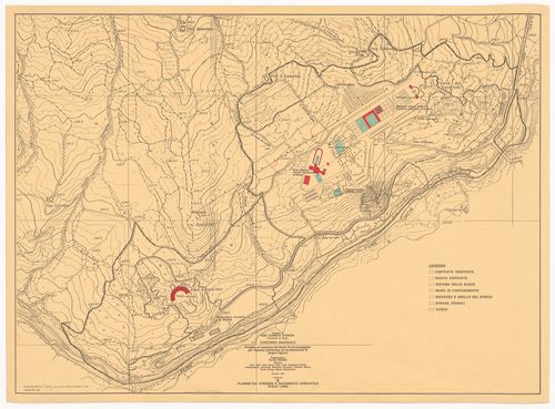
Map for Piano particolareggiato per l'assetto ambientale ed architettonico di Bagno Vignoni, Italy
Map for Piano particolareggiato per l'assetto ambientale ed architettonico di Bagno Vignoni, Italy
Actions:
Reference number:
AP142.S1.D224.P5.3
AP142.S1.D224.P5.3
People:
Date:
1993
1993
Title:
Map for Piano particolareggiato per l'assetto ambientale ed architettonico di Bagno Vignoni, Italy
Actions:
AP142.S1.D224.P5.3
Map for Piano particolareggiato per l'assetto ambientale ed architettonico di Bagno Vignoni, Italy
Actions:
AP142.S1.D224.P5.3
Form:
drawings
drawings
Date:
1993
1993
People:
Form:
drawings
drawings
Actions:
Reference number:
ARCH288316
ARCH288316
People:
Date:
circa 1961-1980
circa 1961-1980
Form:
drawings
drawings
Date:
circa 1961-1980
circa 1961-1980
People:
Form:
maps, drawings
maps, drawings
Title:
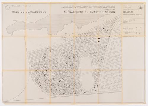
Map of proposed restructuring by René Van Veen for Nossin neighbourhood, Ouagadougou, Burkina Faso
Map of proposed restructuring by René Van Veen for Nossin neighbourhood, Ouagadougou, Burkina Faso
Actions:
Reference number:
ARCH279643
ARCH279643
People:
Date:
1982
1982
Form:
maps, drawings
maps, drawings
Date:
1982
1982
People:
Form:
drawings
drawings
Title:
Site information - survey plans, site plans, utility map index, axonometrics of downtown Edmonton
Site information - survey plans, site plans, utility map index, axonometrics of downtown Edmonton
Actions:
Reference number:
ARCH259297
ARCH259297
People:
Date:
circa 1984
circa 1984
Form:
drawings
drawings
Date:
circa 1984
circa 1984
People:
Form:
drawings
drawings
Title:
Site plan, carport and roof plan, floor plans, elevations, sections, topographical map, details
Site plan, carport and roof plan, floor plans, elevations, sections, topographical map, details
Actions:
Reference number:
ARCH261727
ARCH261727
People:
Date:
1972
1972
Form:
drawings
drawings
Date:
1972
1972
People:
Form:
drawings
Quantity:
18 working drawing(s)
drawings
Quantity:
18 working drawing(s)
Actions:
Reference number:
DR1995:0252:433-450
DR1995:0252:433-450
People:
Title:
Elevations, sections, internal elevations, ordnance map showing public utilities, site plans, and plans
Actions:
DR1995:0252:433-450
Elevations, sections, internal elevations, ordnance map showing public utilities, site plans, and plans
Actions:
DR1995:0252:433-450
Form:
drawings
Quantity:
18 working drawing(s)
drawings
Quantity:
18 working drawing(s)
People:
Form:
drawings
Quantity:
17 design development drawing(s)
drawings
Quantity:
17 design development drawing(s)
Actions:
Reference number:
DR1995:0216:157-173
Description:
site plan, sketch regional map, plans, sections, and axonometric sketches of Madeley and Meir transfer areas, plans, sections, elevations, and master diagram of housing sites
DR1995:0216:157-173
Description:
site plan, sketch regional map, plans, sections, and axonometric sketches of Madeley and Meir transfer areas, plans, sections, elevations, and master diagram of housing sites
People:
Title:
Site plan, sketch regional map, plans, sections, and axonometric sketches of Madeley and Meir transfer areas
Actions:
DR1995:0216:157-173
Description:
site plan, sketch regional map, plans, sections, and axonometric sketches of Madeley and Meir transfer areas, plans, sections, elevations, and master diagram of housing sites
Form:
drawings
Quantity:
17 design development drawing(s)
drawings
Quantity:
17 design development drawing(s)
People:
Form:
maps, drawings, works of art
maps, drawings, works of art
Actions:
Reference number:
DR1974:0002:030:009:001-003
DR1974:0002:030:009:001-003
People:
Subject:
architecture, topographic
architecture, topographic
Date:
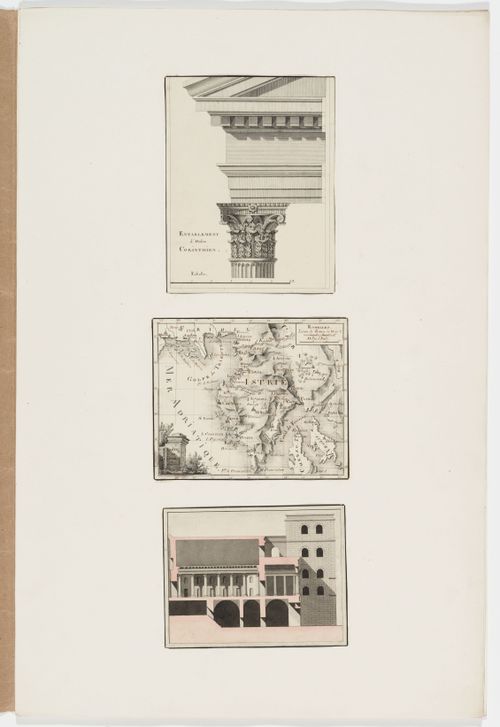
printed between 1800 and 1846
printed between 1800 and 1846
Title:
Elevation of a Corinthian capital and entablature; Map of Istria; Sectional elevation of an unidentified building
Actions:
DR1974:0002:030:009:001-003
Elevation of a Corinthian capital and entablature; Map of Istria; Sectional elevation of an unidentified building
Actions:
DR1974:0002:030:009:001-003
Form:
maps, drawings, works of art
maps, drawings, works of art
Date:
printed between 1800 and 1846
printed between 1800 and 1846
People:
Subject:
architecture, topographic
architecture, topographic