34822 Results
Form:
textual records
textual records
Actions:
Reference number:
ARCH257215
Description:
1 file - Burroughs Holdings, apartment / condo project, Surrey, BC. (c.1969-1971): area calculations, site map (copies), memo, district information, correspondence, notes
ARCH257215
Description:
1 file - Burroughs Holdings, apartment / condo project, Surrey, BC. (c.1969-1971): area calculations, site map (copies), memo, district information, correspondence, notes
People:
Date:
1971
1971
Title:
Area calculations, site map, memo, district information, correspondence, and notes related to Burroughs Holdings, apartment and condo project
Actions:
ARCH257215
Description:
1 file - Burroughs Holdings, apartment / condo project, Surrey, BC. (c.1969-1971): area calculations, site map (copies), memo, district information, correspondence, notes
Form:
textual records
textual records
Date:
1971
1971
People:
Form:
maps, drawings
maps, drawings
Title:
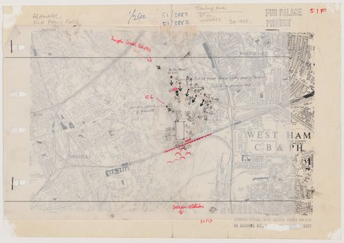
Map with overlaid sketch indicating the site for the Fun Palace at Mill Meads (Fun Palace project)
Map with overlaid sketch indicating the site for the Fun Palace at Mill Meads (Fun Palace project)
Actions:
Reference number:
DR1995:0188:111
DR1995:0188:111
People:
Date:
1965?
1965?
Title:
Map with overlaid sketch indicating the site for the Fun Palace at Mill Meads (Fun Palace project)
Actions:
DR1995:0188:111
Map with overlaid sketch indicating the site for the Fun Palace at Mill Meads (Fun Palace project)
Actions:
DR1995:0188:111
Form:
maps, drawings
maps, drawings
Date:
1965?
1965?
People:
Form:
drawings
drawings
Actions:
Reference number:
DR1987:0446
Description:
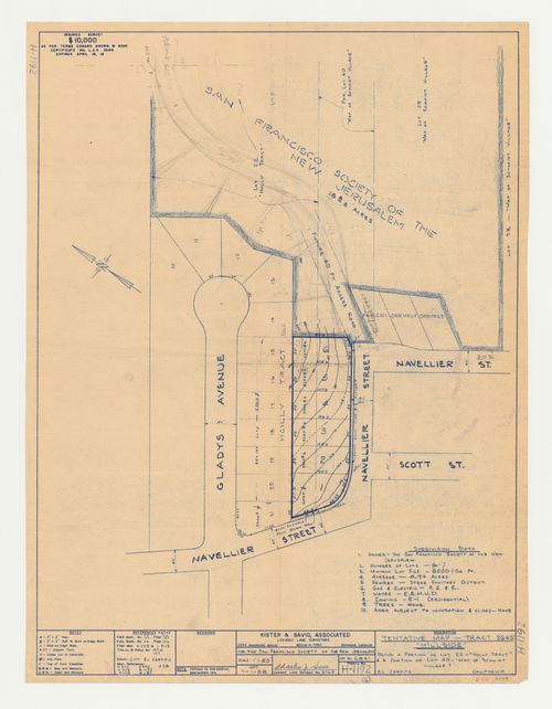
- This diazotype of a survey of the site has been used by the draughtsman as a base on which to plot out the path of the road and to experiment with alternative lot subdivisions.
DR1987:0446
Description:
- This diazotype of a survey of the site has been used by the draughtsman as a base on which to plot out the path of the road and to experiment with alternative lot subdivisions.
People:
Subject:
architecture, topographic
architecture, topographic
Date:
after 1 July 1958
after 1 July 1958
Title:
Swedenborg Memorial Chapel, El Cerrito, California: Sketches for lot subdivision on a survey map of the site
Actions:
DR1987:0446
Description:
- This diazotype of a survey of the site has been used by the draughtsman as a base on which to plot out the path of the road and to experiment with alternative lot subdivisions.
Form:
drawings
drawings
Date:
after 1 July 1958
after 1 July 1958
People:
Subject:
architecture, topographic
architecture, topographic
Form:
drawings
Quantity:
73 presentation drawing(s)
drawings
Quantity:
73 presentation drawing(s)
Actions:
Reference number:
AP142.S1.D220.P10
AP142.S1.D220.P10
People:
Title:
Site plans, plans, elevations, sections, axonometrics, a map, details, and colour printouts of views of a model
Actions:
AP142.S1.D220.P10
Site plans, plans, elevations, sections, axonometrics, a map, details, and colour printouts of views of a model
Actions:
AP142.S1.D220.P10
Form:
drawings
Quantity:
73 presentation drawing(s)
drawings
Quantity:
73 presentation drawing(s)
People:
Form:
drawings
drawings
Actions:
Reference number:
DR1987:0439 R/V
Description:
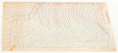
- This grading plan includes outlines of two buildings and the road. The buildings and two of the contour lines have been traced on the verso.
DR1987:0439 R/V
Description:
- This grading plan includes outlines of two buildings and the road. The buildings and two of the contour lines have been traced on the verso.
People:
Subject:
architecture
architecture
Date:
1962
1962
Title:
Swedenborg Memorial Chapel, El Cerrito, California: Partial contour map with additions, probably indicating grading changes
Actions:
DR1987:0439 R/V
Description:
- This grading plan includes outlines of two buildings and the road. The buildings and two of the contour lines have been traced on the verso.
Form:
drawings
drawings
Date:
1962
1962
People:
Subject:
architecture
architecture
Form:
drawings
drawings
Actions:
Reference number:
ARCH261216
ARCH261216
People:
Date:
1990
1990
Form:
drawings
drawings
Date:
1990
1990
People:
Form:
drawings
drawings
Actions:
Reference number:
AP142.S1.D210.P4
AP142.S1.D210.P4
People:
Form:
drawings
drawings
People:
Form:
maps, drawings
maps, drawings
Actions:
Reference number:
DR1995:0280:257
Description:
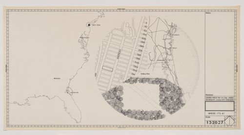
Caption title: Where it's at
DR1995:0280:257
Description:
Caption title: Where it's at
People:
Date:
circa 1976
circa 1976
Title:
Site plan for Generator, Yulee, Florida, with a map of the East Coast of the United States and inset maps of Manhattan and the area around Jacksonville, Florida
Actions:
DR1995:0280:257
Description:
Caption title: Where it's at
Site plan for Generator, Yulee, Florida, with a map of the East Coast of the United States and inset maps of Manhattan and the area around Jacksonville, Florida
Actions:
DR1995:0280:257
Description:
Caption title: Where it's at
Form:
maps, drawings
maps, drawings
Date:
circa 1976
circa 1976
People:
Form:
drawings
drawings
Actions:
Reference number:
AP018.S1.1971.PR07.015
AP018.S1.1971.PR07.015
People:
Date:
1971
1971
Form:
drawings
drawings
Date:
1971
1971
People:
Form:
drawings
drawings
Actions:
Reference number:
ARCH257053
ARCH257053
People:
Date:
circa 1987
circa 1987
Form:
drawings
drawings
Date:
circa 1987
circa 1987
People: