


24940 Results
Level of archival description:
Project
Project
Actions:
Reference number:
CI005.S1.1917.PR3
Description:
The Seafront Terrace Housing, or "Strandboulevard" was originally designed by Oud for the property developer, Maatschappij Oostduinen Scheveningen. Oud was originally commissioned to build only for one strip of development. He designed nine three-storey luxury units that could be repeated any number of times. Oud's contemporaries viewed the design as embodying the Dutch artistic movement, De Stijl. The sea-front elevation for the design is cubic. While Oud eventually opted for an unornamented design, his original drawings featured masonry ornaments and panelling (Taverne et al. 2001, 145-148). Project series includes drawings of plans, photographs of drawings, and a photograph of a model.
CI005.S1.1917.PR3
Description:
The Seafront Terrace Housing, or "Strandboulevard" was originally designed by Oud for the property developer, Maatschappij Oostduinen Scheveningen. Oud was originally commissioned to build only for one strip of development. He designed nine three-storey luxury units that could be repeated any number of times. Oud's contemporaries viewed the design as embodying the Dutch artistic movement, De Stijl. The sea-front elevation for the design is cubic. While Oud eventually opted for an unornamented design, his original drawings featured masonry ornaments and panelling (Taverne et al. 2001, 145-148). Project series includes drawings of plans, photographs of drawings, and a photograph of a model.
People:
Date:
1916
1916
Title:
Seafront Terrace Housing (Strandboulevard), The Hague, Netherlands (1916)
Actions:
CI005.S1.1917.PR3
Description:
The Seafront Terrace Housing, or "Strandboulevard" was originally designed by Oud for the property developer, Maatschappij Oostduinen Scheveningen. Oud was originally commissioned to build only for one strip of development. He designed nine three-storey luxury units that could be repeated any number of times. Oud's contemporaries viewed the design as embodying the Dutch artistic movement, De Stijl. The sea-front elevation for the design is cubic. While Oud eventually opted for an unornamented design, his original drawings featured masonry ornaments and panelling (Taverne et al. 2001, 145-148). Project series includes drawings of plans, photographs of drawings, and a photograph of a model.
Seafront Terrace Housing (Strandboulevard), The Hague, Netherlands (1916)
Actions:
CI005.S1.1917.PR3
Description:
The Seafront Terrace Housing, or "Strandboulevard" was originally designed by Oud for the property developer, Maatschappij Oostduinen Scheveningen. Oud was originally commissioned to build only for one strip of development. He designed nine three-storey luxury units that could be repeated any number of times. Oud's contemporaries viewed the design as embodying the Dutch artistic movement, De Stijl. The sea-front elevation for the design is cubic. While Oud eventually opted for an unornamented design, his original drawings featured masonry ornaments and panelling (Taverne et al. 2001, 145-148). Project series includes drawings of plans, photographs of drawings, and a photograph of a model.
Level of archival description:
project
project
Date:
1916
1916
People:
Level of archival description:
Project
Project
Reference number:
AP207.S1.1978.PR03
Description:
The project series documents "Icone Del Passato" an installation showing a hammer and sickle representing ideologies' icons described by Pettena as "icons of the past." "The time of ideologies, which deeply influenced actions of men in the nineteenth century, is now over. Just some icons remain, no longer in use, hung to a wall on a nail." [1] The project series contains photographs showing the two tools hanging on a nail and a photograph showing similar tools hanging in a room. Source: [1] Gianni Pettena website, https://www.giannipettena.it/italiano/opere-1/inst-icons-of-the-past-1975/ (last accessed 11 December 2019)
AP207.S1.1978.PR03
Description:
The project series documents "Icone Del Passato" an installation showing a hammer and sickle representing ideologies' icons described by Pettena as "icons of the past." "The time of ideologies, which deeply influenced actions of men in the nineteenth century, is now over. Just some icons remain, no longer in use, hung to a wall on a nail." [1] The project series contains photographs showing the two tools hanging on a nail and a photograph showing similar tools hanging in a room. Source: [1] Gianni Pettena website, https://www.giannipettena.it/italiano/opere-1/inst-icons-of-the-past-1975/ (last accessed 11 December 2019)
People:
Date:
circa 1978-2018
circa 1978-2018
Title:
Icone Del Passato [Icones of the Past] (1978)
Actions:
AP207.S1.1978.PR03
Description:
The project series documents "Icone Del Passato" an installation showing a hammer and sickle representing ideologies' icons described by Pettena as "icons of the past." "The time of ideologies, which deeply influenced actions of men in the nineteenth century, is now over. Just some icons remain, no longer in use, hung to a wall on a nail." [1] The project series contains photographs showing the two tools hanging on a nail and a photograph showing similar tools hanging in a room. Source: [1] Gianni Pettena website, https://www.giannipettena.it/italiano/opere-1/inst-icons-of-the-past-1975/ (last accessed 11 December 2019)
Icone Del Passato [Icones of the Past] (1978)
Actions:
AP207.S1.1978.PR03
Description:
The project series documents "Icone Del Passato" an installation showing a hammer and sickle representing ideologies' icons described by Pettena as "icons of the past." "The time of ideologies, which deeply influenced actions of men in the nineteenth century, is now over. Just some icons remain, no longer in use, hung to a wall on a nail." [1] The project series contains photographs showing the two tools hanging on a nail and a photograph showing similar tools hanging in a room. Source: [1] Gianni Pettena website, https://www.giannipettena.it/italiano/opere-1/inst-icons-of-the-past-1975/ (last accessed 11 December 2019)
Level of archival description:
Project
Project
Date:
circa 1978-2018
circa 1978-2018
People:
Level of archival description:
Project
Project
Reference number:
AP207.S1.2011.PR03
Description:
The project series documents "La Mia Scuola D'Architettura" a series of photographs of the Dolomites at the time of Pettena's childhood. The landscape, considered as his school of architecture, is "simply photographed and catalogued, thereby acknowledging at one and the same time the inevitable supremacy of nature, as "begetter" of architecture, and the acceptance of this lesson both conceptually and in its infinite spatial and linguistic." [1] The project series contains photographs and a printout out of a photo montage of natural geological formation. Source: [1] Gianni Pettena website, https://www.giannipettena.it/italiano/opere-1/nat-my-school-2011/ (last accessed 23 January 2020)
AP207.S1.2011.PR03
Description:
The project series documents "La Mia Scuola D'Architettura" a series of photographs of the Dolomites at the time of Pettena's childhood. The landscape, considered as his school of architecture, is "simply photographed and catalogued, thereby acknowledging at one and the same time the inevitable supremacy of nature, as "begetter" of architecture, and the acceptance of this lesson both conceptually and in its infinite spatial and linguistic." [1] The project series contains photographs and a printout out of a photo montage of natural geological formation. Source: [1] Gianni Pettena website, https://www.giannipettena.it/italiano/opere-1/nat-my-school-2011/ (last accessed 23 January 2020)
People:
Date:
2011-2015
2011-2015
Title:
La Mia Scualo D'Architettura [My School of Architecture] (2011)
Actions:
AP207.S1.2011.PR03
Description:
The project series documents "La Mia Scuola D'Architettura" a series of photographs of the Dolomites at the time of Pettena's childhood. The landscape, considered as his school of architecture, is "simply photographed and catalogued, thereby acknowledging at one and the same time the inevitable supremacy of nature, as "begetter" of architecture, and the acceptance of this lesson both conceptually and in its infinite spatial and linguistic." [1] The project series contains photographs and a printout out of a photo montage of natural geological formation. Source: [1] Gianni Pettena website, https://www.giannipettena.it/italiano/opere-1/nat-my-school-2011/ (last accessed 23 January 2020)
La Mia Scualo D'Architettura [My School of Architecture] (2011)
Actions:
AP207.S1.2011.PR03
Description:
The project series documents "La Mia Scuola D'Architettura" a series of photographs of the Dolomites at the time of Pettena's childhood. The landscape, considered as his school of architecture, is "simply photographed and catalogued, thereby acknowledging at one and the same time the inevitable supremacy of nature, as "begetter" of architecture, and the acceptance of this lesson both conceptually and in its infinite spatial and linguistic." [1] The project series contains photographs and a printout out of a photo montage of natural geological formation. Source: [1] Gianni Pettena website, https://www.giannipettena.it/italiano/opere-1/nat-my-school-2011/ (last accessed 23 January 2020)
Level of archival description:
Project
Project
Date:
2011-2015
2011-2015
People:
Level of archival description:
Sub-series
Sub-series
Actions:
Reference number:
AP115.S3.D2
Description:
Cette sous-série porte sur le travail de documentation photographique de Robert Duchesnay du dôme géodésique Climatron dome à St. Louis, Missouri, aux États-Unis. Conçu en 1960 par les architectes Murphy et Mackey de St. Louis en utilisant le système conçu par Buckminter Fuller, il abrite la serre et le pavillon principal du Missouri Botanical Garden. Le Climatron est la première serre complètement climatisée au monde. Son diamètre est de 175 pieds. Le pavillon sera fermé en 1988 pour un vaste projet de rénovations qui dureront jusqu'en 1990. Le bâtiment est toujours en activité. La sous-série contient cinq photographies, de l'extérieur et de l'intérieur du dôme, prises par Robert Duchesnay en 1990 après sa réouverture à la suite des rénovations. Source: Duchesnay, Robert. "Other domes by Buckminster Fuller". https://robertduchesnay.com/en/other-domes-by-buckminster-fuller/ (page consultée 24 février 2023).
AP115.S3.D2
Description:
Cette sous-série porte sur le travail de documentation photographique de Robert Duchesnay du dôme géodésique Climatron dome à St. Louis, Missouri, aux États-Unis. Conçu en 1960 par les architectes Murphy et Mackey de St. Louis en utilisant le système conçu par Buckminter Fuller, il abrite la serre et le pavillon principal du Missouri Botanical Garden. Le Climatron est la première serre complètement climatisée au monde. Son diamètre est de 175 pieds. Le pavillon sera fermé en 1988 pour un vaste projet de rénovations qui dureront jusqu'en 1990. Le bâtiment est toujours en activité. La sous-série contient cinq photographies, de l'extérieur et de l'intérieur du dôme, prises par Robert Duchesnay en 1990 après sa réouverture à la suite des rénovations. Source: Duchesnay, Robert. "Other domes by Buckminster Fuller". https://robertduchesnay.com/en/other-domes-by-buckminster-fuller/ (page consultée 24 février 2023).
People:
Date:
1990
1990
Title:
Climatron, Saint Louis, Missouri
Actions:
AP115.S3.D2
Description:
Cette sous-série porte sur le travail de documentation photographique de Robert Duchesnay du dôme géodésique Climatron dome à St. Louis, Missouri, aux États-Unis. Conçu en 1960 par les architectes Murphy et Mackey de St. Louis en utilisant le système conçu par Buckminter Fuller, il abrite la serre et le pavillon principal du Missouri Botanical Garden. Le Climatron est la première serre complètement climatisée au monde. Son diamètre est de 175 pieds. Le pavillon sera fermé en 1988 pour un vaste projet de rénovations qui dureront jusqu'en 1990. Le bâtiment est toujours en activité. La sous-série contient cinq photographies, de l'extérieur et de l'intérieur du dôme, prises par Robert Duchesnay en 1990 après sa réouverture à la suite des rénovations. Source: Duchesnay, Robert. "Other domes by Buckminster Fuller". https://robertduchesnay.com/en/other-domes-by-buckminster-fuller/ (page consultée 24 février 2023).
Climatron, Saint Louis, Missouri
Actions:
AP115.S3.D2
Description:
Cette sous-série porte sur le travail de documentation photographique de Robert Duchesnay du dôme géodésique Climatron dome à St. Louis, Missouri, aux États-Unis. Conçu en 1960 par les architectes Murphy et Mackey de St. Louis en utilisant le système conçu par Buckminter Fuller, il abrite la serre et le pavillon principal du Missouri Botanical Garden. Le Climatron est la première serre complètement climatisée au monde. Son diamètre est de 175 pieds. Le pavillon sera fermé en 1988 pour un vaste projet de rénovations qui dureront jusqu'en 1990. Le bâtiment est toujours en activité. La sous-série contient cinq photographies, de l'extérieur et de l'intérieur du dôme, prises par Robert Duchesnay en 1990 après sa réouverture à la suite des rénovations. Source: Duchesnay, Robert. "Other domes by Buckminster Fuller". https://robertduchesnay.com/en/other-domes-by-buckminster-fuller/ (page consultée 24 février 2023).
Level of archival description:
Dossier 2
Dossier 2
Date:
1990
1990
People:
Level of archival description:
Sub-series
Sub-series
Reference number:
AP178.S1.1985.PR02.SS1
Description:
This project subseries documents the Recuperação da Área do Campo di Marte in Giudecca, Venice, Italy. While the records were held in the office’s archives this project was assigned the number 34/80. The office assigned the date 1985 to this project. Documenting this project are sketches, studies and plans. Photographic materials include photographs and negatives of the project site and model. Textual materials include competition documentation, project documentation, notes and technical specifications. Documentation, drawings, and photographs specific to Siza's Projecto para um Edifício de Habitação em Campo di Marte can be found in project subseries AP178.S1.1985.PR02.SS2.
AP178.S1.1985.PR02.SS1
Description:
This project subseries documents the Recuperação da Área do Campo di Marte in Giudecca, Venice, Italy. While the records were held in the office’s archives this project was assigned the number 34/80. The office assigned the date 1985 to this project. Documenting this project are sketches, studies and plans. Photographic materials include photographs and negatives of the project site and model. Textual materials include competition documentation, project documentation, notes and technical specifications. Documentation, drawings, and photographs specific to Siza's Projecto para um Edifício de Habitação em Campo di Marte can be found in project subseries AP178.S1.1985.PR02.SS2.
People:
Date:
1984-2012
1984-2012
Title:
Recuperação da Área do Campo di Marte [Restoration of Campo di Marte], Giudecca, Venice, Italy (1985)
Actions:
AP178.S1.1985.PR02.SS1
Description:
This project subseries documents the Recuperação da Área do Campo di Marte in Giudecca, Venice, Italy. While the records were held in the office’s archives this project was assigned the number 34/80. The office assigned the date 1985 to this project. Documenting this project are sketches, studies and plans. Photographic materials include photographs and negatives of the project site and model. Textual materials include competition documentation, project documentation, notes and technical specifications. Documentation, drawings, and photographs specific to Siza's Projecto para um Edifício de Habitação em Campo di Marte can be found in project subseries AP178.S1.1985.PR02.SS2.
Recuperação da Área do Campo di Marte [Restoration of Campo di Marte], Giudecca, Venice, Italy (1985)
Actions:
AP178.S1.1985.PR02.SS1
Description:
This project subseries documents the Recuperação da Área do Campo di Marte in Giudecca, Venice, Italy. While the records were held in the office’s archives this project was assigned the number 34/80. The office assigned the date 1985 to this project. Documenting this project are sketches, studies and plans. Photographic materials include photographs and negatives of the project site and model. Textual materials include competition documentation, project documentation, notes and technical specifications. Documentation, drawings, and photographs specific to Siza's Projecto para um Edifício de Habitação em Campo di Marte can be found in project subseries AP178.S1.1985.PR02.SS2.
Level of archival description:
Project
Project
Date:
1984-2012
1984-2012
People:
Form:
photographs
photographs
Actions:
Reference number:
PH1981:0489
Description:
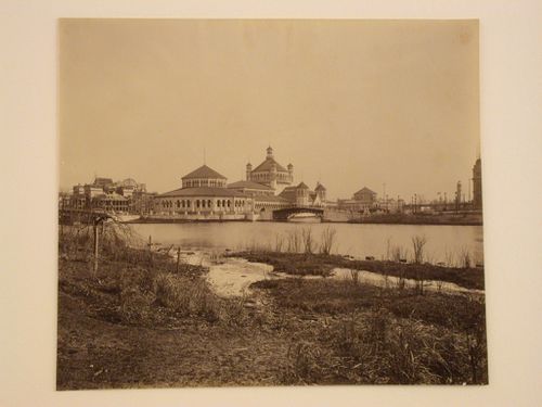
- This photograph shows a bridge connecting the Fisheries Building to the Wooded Island on the left and a bridge connecting the Fisheries Building to the Government Building in the center, both across the Lagoon. The Brazilian Government Building (?) is under construction in the left background.
PH1981:0489
Description:
- This photograph shows a bridge connecting the Fisheries Building to the Wooded Island on the left and a bridge connecting the Fisheries Building to the Government Building in the center, both across the Lagoon. The Brazilian Government Building (?) is under construction in the left background.
People:
Subject:
architecture
architecture
Date:
1892
1892
Title:
Oblique view of the principal façade of the Fisheries Building from the Wooded Island with the west polygonal building in the foreground, 1893 Chicago World's Columbian Exhibition, Chicago, Illinois
Actions:
PH1981:0489
Description:
- This photograph shows a bridge connecting the Fisheries Building to the Wooded Island on the left and a bridge connecting the Fisheries Building to the Government Building in the center, both across the Lagoon. The Brazilian Government Building (?) is under construction in the left background.
Oblique view of the principal façade of the Fisheries Building from the Wooded Island with the west polygonal building in the foreground, 1893 Chicago World's Columbian Exhibition, Chicago, Illinois
Actions:
PH1981:0489
Description:
- This photograph shows a bridge connecting the Fisheries Building to the Wooded Island on the left and a bridge connecting the Fisheries Building to the Government Building in the center, both across the Lagoon. The Brazilian Government Building (?) is under construction in the left background.
Form:
photographs
photographs
Date:
1892
1892
People:
Subject:
architecture
architecture
Form:
photographs
photographs
Actions:
Reference number:
PH1980:0817:028
Description:
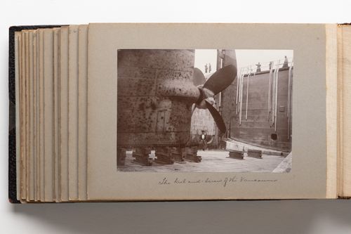
Photograph shows the keel and screw (propellor) on a steamship. The ship is raised on steel beams inside a dry dock. A woman sits on a portion of the propellor and is posed for the camera. At top right, people standing on the dock are visible observing the ship.
PH1980:0817:028
Description:
Photograph shows the keel and screw (propellor) on a steamship. The ship is raised on steel beams inside a dry dock. A woman sits on a portion of the propellor and is posed for the camera. At top right, people standing on the dock are visible observing the ship.
People:
Date:
1889-1896
1889-1896
Title:
View of the lower back portion of a steamship in dry dock, Quebec City, Quebec, Canada
Actions:
PH1980:0817:028
Description:
Photograph shows the keel and screw (propellor) on a steamship. The ship is raised on steel beams inside a dry dock. A woman sits on a portion of the propellor and is posed for the camera. At top right, people standing on the dock are visible observing the ship.
View of the lower back portion of a steamship in dry dock, Quebec City, Quebec, Canada
Actions:
PH1980:0817:028
Description:
Photograph shows the keel and screw (propellor) on a steamship. The ship is raised on steel beams inside a dry dock. A woman sits on a portion of the propellor and is posed for the camera. At top right, people standing on the dock are visible observing the ship.
Form:
photographs
photographs
Date:
1889-1896
1889-1896
People:
Form:
photographs
photographs
Actions:
Reference number:
PH1981:0620:052
Description:
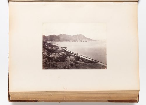
- A hand-written table of contents accompanies album PH1981:0620:001-081. - This photograph was taken from Kellet Island in Hong Kong harbour. East Point, the location of the godowns of Jardine Matheson & Co., is visible at centre left ('Picturing Hong Kong', p. 31, repr.).
PH1981:0620:052
Description:
- A hand-written table of contents accompanies album PH1981:0620:001-081. - This photograph was taken from Kellet Island in Hong Kong harbour. East Point, the location of the godowns of Jardine Matheson & Co., is visible at centre left ('Picturing Hong Kong', p. 31, repr.).
People:
Subject:
architecture, topographic
architecture, topographic
Date:
1867 or after
1867 or after
Title:
Panoramic view of Hong Kong (now Hong Kong, China) and Hong Kong harbour
Actions:
PH1981:0620:052
Description:
- A hand-written table of contents accompanies album PH1981:0620:001-081. - This photograph was taken from Kellet Island in Hong Kong harbour. East Point, the location of the godowns of Jardine Matheson & Co., is visible at centre left ('Picturing Hong Kong', p. 31, repr.).
Panoramic view of Hong Kong (now Hong Kong, China) and Hong Kong harbour
Actions:
PH1981:0620:052
Description:
- A hand-written table of contents accompanies album PH1981:0620:001-081. - This photograph was taken from Kellet Island in Hong Kong harbour. East Point, the location of the godowns of Jardine Matheson & Co., is visible at centre left ('Picturing Hong Kong', p. 31, repr.).
Form:
photographs
photographs
Date:
1867 or after
1867 or after
People:
Subject:
architecture, topographic
architecture, topographic
Form:
photographs
photographs
Actions:
Reference number:
PH1985:0692:001-002
Description:
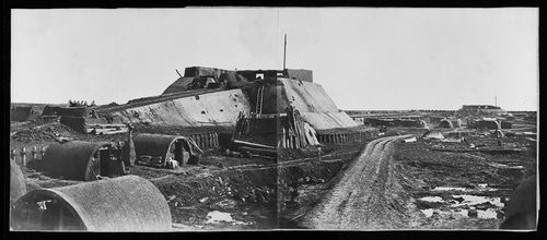
- The inscribed title is on a separate piece of paper which was possibly detached from an album page or previous mount. - This photograph is one in a series of views which Felice Beato made of the four Taku Forts (Harris, p. 139; Worswick, p. 138).
PH1985:0692:001-002
Description:
- The inscribed title is on a separate piece of paper which was possibly detached from an album page or previous mount. - This photograph is one in a series of views which Felice Beato made of the four Taku Forts (Harris, p. 139; Worswick, p. 138).
People:
Subject:
architecture, engineering, military
architecture, engineering, military
Date:
between 22 August and 21 September 1860
between 22 August and 21 September 1860
Title:
Panorama of the Lower North Taku Fort (also known as the 2nd North Fort) showing earthwork cavaliers and defensive walls, Taku (now Dagu), near Tientsin (now Tianjin), China
Actions:
PH1985:0692:001-002
Description:
- The inscribed title is on a separate piece of paper which was possibly detached from an album page or previous mount. - This photograph is one in a series of views which Felice Beato made of the four Taku Forts (Harris, p. 139; Worswick, p. 138).
Panorama of the Lower North Taku Fort (also known as the 2nd North Fort) showing earthwork cavaliers and defensive walls, Taku (now Dagu), near Tientsin (now Tianjin), China
Actions:
PH1985:0692:001-002
Description:
- The inscribed title is on a separate piece of paper which was possibly detached from an album page or previous mount. - This photograph is one in a series of views which Felice Beato made of the four Taku Forts (Harris, p. 139; Worswick, p. 138).
Form:
photographs
photographs
Date:
between 22 August and 21 September 1860
between 22 August and 21 September 1860
People:
Subject:
architecture, engineering, military
architecture, engineering, military
Form:
photographs
photographs
Actions:
Reference number:
PH1980:1132
Description:
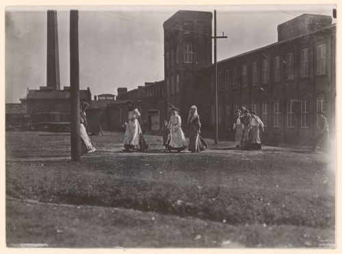
In the foreground are several women. A young girl is holding the arm of one of the women. Photograph taken while Lewis Wickes Hine was working for the National Child Labor Committee. Caption from NCLC caption card: "Noon Hour, Manchester Cotton Mill, Macon, Ga."
PH1980:1132
Description:
In the foreground are several women. A young girl is holding the arm of one of the women. Photograph taken while Lewis Wickes Hine was working for the National Child Labor Committee. Caption from NCLC caption card: "Noon Hour, Manchester Cotton Mill, Macon, Ga."
People:
Date:
January 1909
January 1909
Title:
View of workers leaving Manchester Cotton Mill at noon, Macon, Georgia, United States
Actions:
PH1980:1132
Description:
In the foreground are several women. A young girl is holding the arm of one of the women. Photograph taken while Lewis Wickes Hine was working for the National Child Labor Committee. Caption from NCLC caption card: "Noon Hour, Manchester Cotton Mill, Macon, Ga."
View of workers leaving Manchester Cotton Mill at noon, Macon, Georgia, United States
Actions:
PH1980:1132
Description:
In the foreground are several women. A young girl is holding the arm of one of the women. Photograph taken while Lewis Wickes Hine was working for the National Child Labor Committee. Caption from NCLC caption card: "Noon Hour, Manchester Cotton Mill, Macon, Ga."
Form:
photographs
photographs
Date:
January 1909
January 1909
People:


