34824 Results
Form:
maps, works of art
maps, works of art
Title:
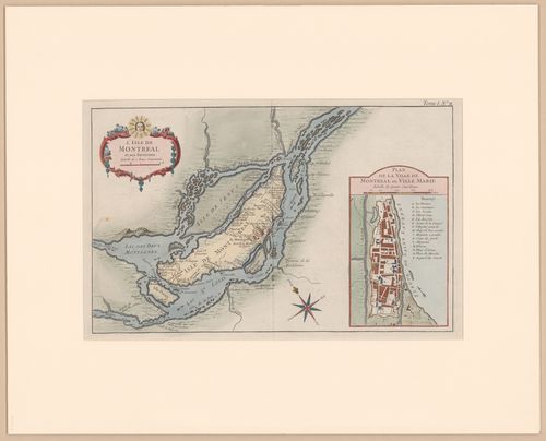
Map of the Island of Montréal and its surroundings / Carte de l'île de Montréal et de ses environs
Map of the Island of Montréal and its surroundings / Carte de l'île de Montréal et de ses environs
Actions:
Reference number:
DR1982:0235
DR1982:0235
People:
Subject:
topographic
topographic
Date:
1764 (deuxième état)
1764 (deuxième état)
Title:
Map of the Island of Montréal and its surroundings / Carte de l'île de Montréal et de ses environs
Actions:
DR1982:0235
Map of the Island of Montréal and its surroundings / Carte de l'île de Montréal et de ses environs
Actions:
DR1982:0235
Form:
maps, works of art
maps, works of art
Date:
1764 (deuxième état)
1764 (deuxième état)
People:
Subject:
topographic
topographic
Form:
drawings
drawings
Actions:
Reference number:
AP140.S2.SS1.D97.P115
AP140.S2.SS1.D97.P115
People:
Date:
circa 1974-1999
circa 1974-1999
Form:
drawings
drawings
Date:
circa 1974-1999
circa 1974-1999
People:
Form:
maps, photographs
maps, photographs
Actions:
Reference number:
PH2001:0058
PH2001:0058
People:
Subject:
topographic
topographic
Date:
between 1967 and 1971
between 1967 and 1971
Form:
maps, photographs
maps, photographs
Date:
between 1967 and 1971
between 1967 and 1971
People:
Subject:
topographic
topographic
Form:
textual records
textual records
Actions:
Reference number:
AP058.S1.SS2.030
AP058.S1.SS2.030
People:
Date:
1973-1980
1973-1980
Form:
textual records
textual records
Date:
1973-1980
1973-1980
People:
Form:
drawings
Quantity:
14 reference drawing(s)
drawings
Quantity:
14 reference drawing(s)
Actions:
Reference number:
AP142.S1.D179.P1
AP142.S1.D179.P1
People:
Form:
drawings
Quantity:
14 reference drawing(s)
drawings
Quantity:
14 reference drawing(s)
People:

Actions:
Reference number:
AP142.S1.D84.P1.1
Description:
Map dated 1970.
AP142.S1.D84.P1.1
Description:
Map dated 1970.
People:
Date:
1984
1984
Title:
Folded map of Venice in a portfolio issued in conjunction with the competition to redevelop the Campo di Marte area of La Giudecca, Venice, Italy
Actions:
AP142.S1.D84.P1.1
Description:
Map dated 1970.
Folded map of Venice in a portfolio issued in conjunction with the competition to redevelop the Campo di Marte area of La Giudecca, Venice, Italy
Actions:
AP142.S1.D84.P1.1
Description:
Map dated 1970.
Date:
1984
1984
People:
Form:
maps, works of art
maps, works of art
Actions:
Reference number:
DR1974:0002:008:077
DR1974:0002:008:077
People:
Subject:
architecture
architecture
Date:
printed after 1842
printed after 1842
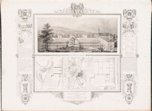
Title:
Asile départemental d'aliénés, Dijon: Perspective drawing, site plan, and floor plan with a map of Dijon and its environs
Actions:
DR1974:0002:008:077
Asile départemental d'aliénés, Dijon: Perspective drawing, site plan, and floor plan with a map of Dijon and its environs
Actions:
DR1974:0002:008:077
Form:
maps, works of art
maps, works of art
Date:
printed after 1842
printed after 1842
People:
Subject:
architecture
architecture
Form:
works of art
Quantity:
2 print(s)
works of art
Quantity:
2 print(s)
Actions:
Reference number:
DR1986:0224
DR1986:0224
People:
Subject:
topographic
topographic
Date:
October 1792 (map)
October 1792 (map)
Form:
works of art
Quantity:
2 print(s)
works of art
Quantity:
2 print(s)
Date:
October 1792 (map)
October 1792 (map)
People:
Subject:
topographic
topographic
Form:
maps, drawings
maps, drawings
![Annotated map of Italy showing the location of Apecchio for Zeno, une cultura autosufficiente [Zeno, a self-sufficient culture]](/img-collection/2-oXVb4eP5O2ceRRgOiAi8DuVjA=/500x396/485588.jpg)
Actions:
Reference number:
ARCH400289
ARCH400289
People:
Date:
1976
1976
Form:
maps, drawings
maps, drawings
Date:
1976
1976
People:
Form:
drawings
drawings
Actions:
Reference number:
ARCH260574
ARCH260574
People:
Form:
drawings
drawings
People: