705 Results
Form:
books
books
Actions:
Holdings:
Description:
viii, 695 pages : illustrations ; 31 cm
Description:
viii, 695 pages : illustrations ; 31 cm
Author:
Subject:
Publication:
Paris : Bibliothèque nationale, Dép. des cartes et plans, 1984.
Paris : Bibliothèque nationale, Dép. des cartes et plans, 1984.
Title:
Les atlas français, XVIe-XVIIe siècles : répertoire bibliographique et étude / par Mireille Pastoureau, avec la collaboration de Frank Lestringant pour l'Insulaire d'A. Thevet.
Actions:
Holdings:
Description:
viii, 695 pages : illustrations ; 31 cm
Les atlas français, XVIe-XVIIe siècles : répertoire bibliographique et étude / par Mireille Pastoureau, avec la collaboration de Frank Lestringant pour l'Insulaire d'A. Thevet.
Actions:
Holdings:
Description:
viii, 695 pages : illustrations ; 31 cm
Form:
books
books
Publication:
Paris : Bibliothèque nationale, Dép. des cartes et plans, 1984.
Paris : Bibliothèque nationale, Dép. des cartes et plans, 1984.
Author:
Subject:
Form:
books
books
Actions:
Holdings:
Description:
xx, 331, [2] pages : tables, folded diagrams ; 26 cm
Description:
xx, 331, [2] pages : tables, folded diagrams ; 26 cm
Author:
Subject:
Publication:
Paris : Courcier, 1807.
Paris : Courcier, 1807.
Title:
Traité de topographie, d'arpentage et de nivellement / par L. Puissant ...
Actions:
Holdings:
Description:
xx, 331, [2] pages : tables, folded diagrams ; 26 cm
Traité de topographie, d'arpentage et de nivellement / par L. Puissant ...
Actions:
Holdings:
Description:
xx, 331, [2] pages : tables, folded diagrams ; 26 cm
Form:
books
books
Publication:
Paris : Courcier, 1807.
Paris : Courcier, 1807.
Author:
Subject:
Form:
books
books
Actions:
Price:
$42.00
(available in store)
Summary:
Nor : Nord, North, Norte. Vingt artistes et huit écrivains canadiens sont invités à incarner leurs « idées du nord ». Leurs œuvres sont recueillies sur les feuilles volantes d’un livre-objet unique. Nor est l’exposition portative et la cartographie imaginaire d’un lieu qui nous habite.
Publication:
October 2004, Montréal
October 2004, Montréal
Title:
Nor : Idées du nord / ideas of north
Actions:
Price:
$42.00
(available in store)
Summary:
Nor : Nord, North, Norte. Vingt artistes et huit écrivains canadiens sont invités à incarner leurs « idées du nord ». Leurs œuvres sont recueillies sur les feuilles volantes d’un livre-objet unique. Nor est l’exposition portative et la cartographie imaginaire d’un lieu qui nous habite.
Form:
books
books
Publication:
October 2004, Montréal
October 2004, Montréal
Form:
books
books
Actions:
Price:
$22.95
(available to order)
Summary:
La Mèche propose un recueil collectif composés de cinq textes qui explorent tous un espace bien précis appartenant à l’auteur.e sollicité.e, qui y habite ou qui y est né.e. Le recueil n’est pas articulé autour d’un thème, la seule contrainte étant celle du territoire. Annie Dulong : Sainte-Martine / Nicholas Dawson : Brossard / Mathieu Leroux : McMasterville / Guillaume(...)
Title:
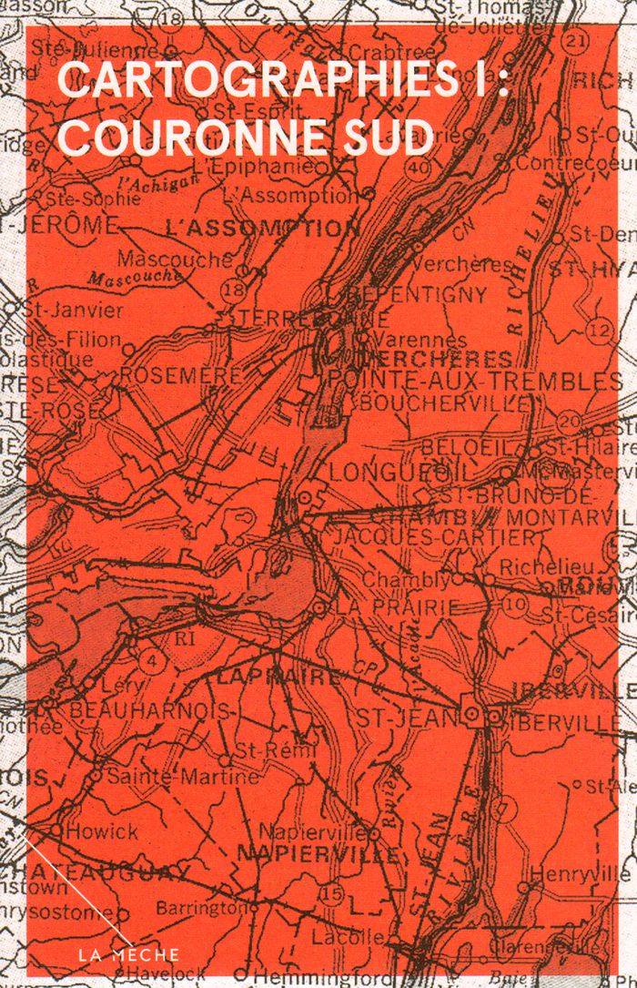
Cartographies 1 : couronne sud
Actions:
Price:
$22.95
(available to order)
Summary:
La Mèche propose un recueil collectif composés de cinq textes qui explorent tous un espace bien précis appartenant à l’auteur.e sollicité.e, qui y habite ou qui y est né.e. Le recueil n’est pas articulé autour d’un thème, la seule contrainte étant celle du territoire. Annie Dulong : Sainte-Martine / Nicholas Dawson : Brossard / Mathieu Leroux : McMasterville / Guillaume Bourque : Boucherville / Eric Godin : Godmanchester.
Form:
books
books
Publication:
October 2016
October 2016
Subject:
Social Studies (Québec)
Social Studies (Québec)
Form:
books
books
Actions:
Price:
$29.95
(available to order)
Summary:
Guide d’architecture de l'Algérie et ses grandes villes - Alger, Oran, Annaba. Pour chacune des villes, une cartographie légendée avec un renvoi au texte illustré par immeuble en facilite la compréhension. Une introduction historique par ville la situe dans son contexte et amène le lecteur à la période qui nous concerne. De plus, quelques encarts sur la carrière des(...)
Subject:
Modernism
Modernism
Publication:
October 2006, Bruxelles
October 2006, Bruxelles
Title:
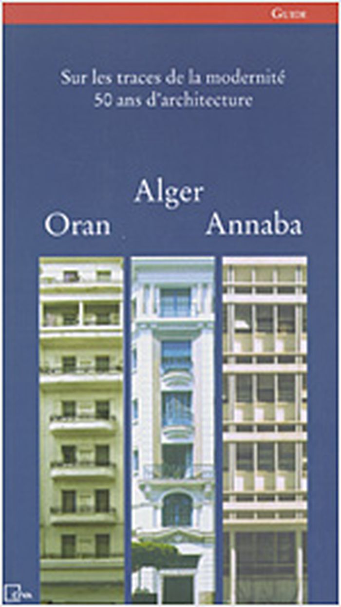
Sur les traces de la modernité, 50 ans d'architecture : Alger, Oran, Annaba
Actions:
Price:
$29.95
(available to order)
Summary:
Guide d’architecture de l'Algérie et ses grandes villes - Alger, Oran, Annaba. Pour chacune des villes, une cartographie légendée avec un renvoi au texte illustré par immeuble en facilite la compréhension. Une introduction historique par ville la situe dans son contexte et amène le lecteur à la période qui nous concerne. De plus, quelques encarts sur la carrière des principaux architectes cités donnent un éclairage qu'il était temps de saisir car les archives sont bien souvent difficiles à retrouver et pour certaines, encore aujourd'hui, elles sont en perdition malgré la prise de conscience de l'intérêt culturel et historique qu'elles représentent. Les bâtiments sélectionnés dans le présent ouvrage ont été regroupés sous forme de promenades ; le visiteur garde néanmoins la possibilité d'organiser lui-même le cheminement de son parcours en utilisant la cartographie, les photos et les commentaires. Texte en français et en arabe.
Form:
books
books
Publication:
October 2006, Bruxelles
October 2006, Bruxelles
Subject:
Modernism
Modernism
Form:
books
books
Actions:
Price:
$21.95
(available to order)
Summary:
Ce livre parle autant d'individus interlopes et attachants, que de lieux étranges et symboliques, tel cet édifice imaginé sur le modèle géométrique du parchís, version catalane du jeu des petits chevaux. Agustín Fernández Mallo campe des atmosphères à faire pâlir les plus grands cinéastes et dessine une cartographie occulte du monde contemporain.
Title:
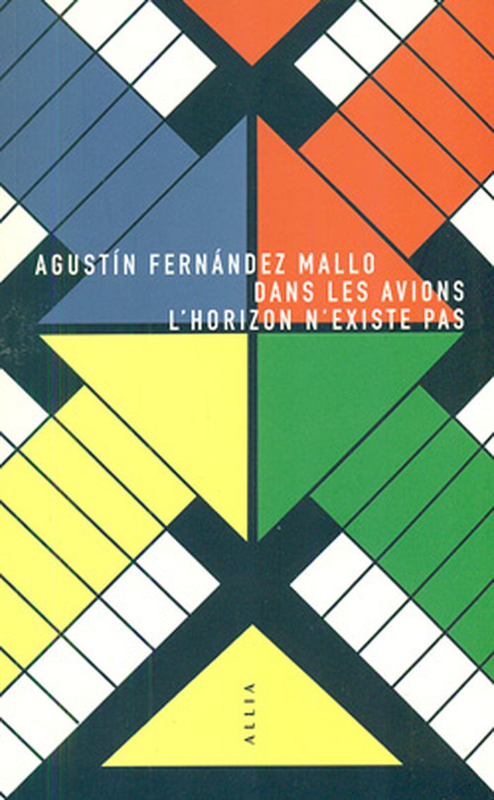
Dans les avions, l'horizon n'existe pas
Actions:
Price:
$21.95
(available to order)
Summary:
Ce livre parle autant d'individus interlopes et attachants, que de lieux étranges et symboliques, tel cet édifice imaginé sur le modèle géométrique du parchís, version catalane du jeu des petits chevaux. Agustín Fernández Mallo campe des atmosphères à faire pâlir les plus grands cinéastes et dessine une cartographie occulte du monde contemporain.
Form:
books
books
Publication:
September 2014
September 2014
Subject:
Critical Theory
Critical Theory
Form:
books
books
Title:
L’hypothèse collaborative
L’hypothèse collaborative
Actions:
Price:
$44.00
(available to order)
Summary:
« L'hypothèse collaborative » est sorti dans le cadre du projet « Lieux infinis » de l'équipe Encore Heureux, commissaire du Pavillon français de la seizième biennale internationale d'architecture de Venise. Ce projet éditorial vise à établir une cartographie problématisée des savoir-faire inventifs, expérimentations heureuses ou malheureuses des “collectifs” français.(...)
Title:
L’hypothèse collaborative
Actions:
Price:
$44.00
(available to order)
Summary:
« L'hypothèse collaborative » est sorti dans le cadre du projet « Lieux infinis » de l'équipe Encore Heureux, commissaire du Pavillon français de la seizième biennale internationale d'architecture de Venise. Ce projet éditorial vise à établir une cartographie problématisée des savoir-faire inventifs, expérimentations heureuses ou malheureuses des “collectifs” français. Les nouveaux enjeux écologiques, possibilités technologiques et données économiques posent questions, et poussent architectes, urbanistes et paysagistes à se tourner vers d’autres voies, méthodologies et finalités alternatives. Comment penser le devenir des territoires dans l’optique d’intégrer l’imprévu, le spontané, l’autonomie habitante? Sur quelles bases et énergies s’appuyer pour concevoir des dynamiques urbaines et rurales plus cohérentes et soutenables ? Notre hypothèse est celle de la collaboration. C’est à un travail de cartographie et d’interrogation de ces nouvelles capacités collaboratives que tente de se livrer ce projet : une éloge de la collaboration, mais aussi une tentative d’en cerner les potentialités latentes, limites, dangers et dérives.
Form:
books
books
Publication:
May 2018
May 2018
Subject:
Urban Theory
Urban Theory
Form:
books
books
Actions:
Price:
$34.95
(available to order)
Summary:
Can capital be seen? Cartographies of the absolute surveys the disparate answers to this question offered by artists, film-makers, writers and theorists over the past few decades. It zones in on the crises of representation that have accompanied the enduring crisis of capitalism, foregrounding the production of new visions and artefacts that wrestle with the vastness,(...)
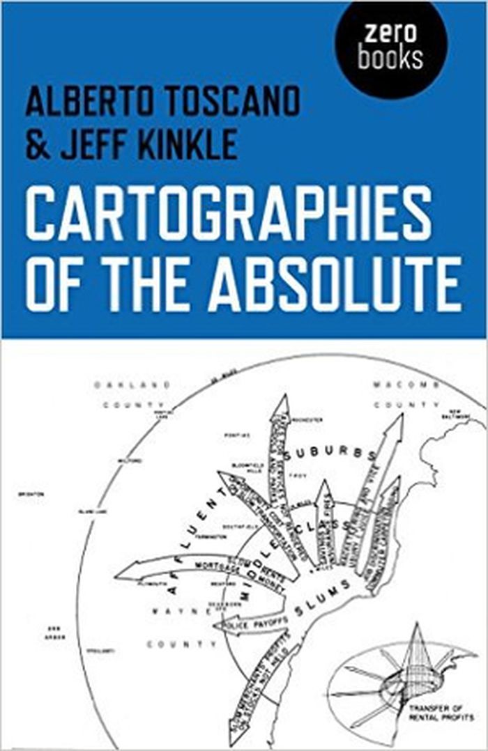
Title:
Cartographies of the absolute
Actions:
Price:
$34.95
(available to order)
Summary:
Can capital be seen? Cartographies of the absolute surveys the disparate answers to this question offered by artists, film-makers, writers and theorists over the past few decades. It zones in on the crises of representation that have accompanied the enduring crisis of capitalism, foregrounding the production of new visions and artefacts that wrestle with the vastness, invisibility and complexity of the abstractions that rule our lives.
Form:
books
books
Publication:
June 2015
June 2015
Subject:
Critical Theory
Critical Theory
Form:
journals and magazines
journals and magazines
Title:
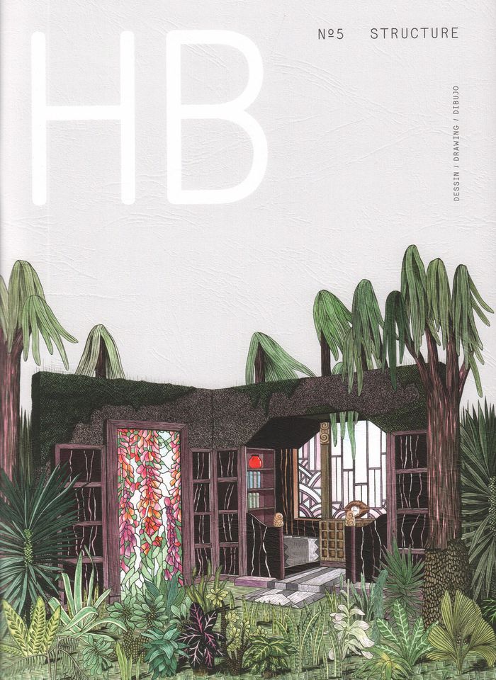
HB no.5 Structure
HB no.5 Structure
Actions:
Price:
$15.00
(available to order)
Summary:
Ligne, trajectoire, plan, programme, système, cartographie, point, voilà certaines des matières qui ont permis, cette fois-ci, d'articuler entre eux les dessins qui composent le numéro 5 de la revue HB. Line, dot, cartography, trajectory, plan, programme, system: these are some of the elements used to articulate the drawings that make up the 5th issue of HB magazine.
Title:
HB no.5 Structure
Actions:
Price:
$15.00
(available to order)
Summary:
Ligne, trajectoire, plan, programme, système, cartographie, point, voilà certaines des matières qui ont permis, cette fois-ci, d'articuler entre eux les dessins qui composent le numéro 5 de la revue HB. Line, dot, cartography, trajectory, plan, programme, system: these are some of the elements used to articulate the drawings that make up the 5th issue of HB magazine.
Form:
journals and magazines
journals and magazines
Publication:
March 2017
March 2017
Subject:
Magazines
Magazines
Form:
books
books
Price:
$50.00
(available to order)
Summary:
Le catalogue de la première Biennale d'architecture d'Orléans : les regards croisés de 45 architectes contemporains sur les manières de construire un monde commun, précédé d'un corpus de textes consacrés aux trois figures tutélaires de cette première biennale, Guy Rottier, Demas Nwoko et Patrick Bouchain. La troisième partie du catalogue présente une cartographie de la(...)
Subject:
Contemporary Architecture
Contemporary Architecture
Publication:
October 2017
October 2017
Title:
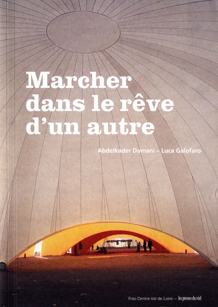
Marcher dans le rêve d’un autre : Biennale d’architecture d’Orléans
Actions:
Price:
$50.00
(available to order)
Summary:
Le catalogue de la première Biennale d'architecture d'Orléans : les regards croisés de 45 architectes contemporains sur les manières de construire un monde commun, précédé d'un corpus de textes consacrés aux trois figures tutélaires de cette première biennale, Guy Rottier, Demas Nwoko et Patrick Bouchain. La troisième partie du catalogue présente une cartographie de la recherche en architecture.
Form:
books
books
Publication:
October 2017
October 2017
Subject:
Contemporary Architecture
Contemporary Architecture