705 Results
Form:
books
books
Actions:
Holdings:
Description:
xiv, 354 pages : illustrations, facsimiles, 1 genealogical table, maps, portraits ; 24 cm.
Description:
xiv, 354 pages : illustrations, facsimiles, 1 genealogical table, maps, portraits ; 24 cm.
Author:
Subject:
Publication:
London : Duckworth Overlook, 2016., ©2016
London : Duckworth Overlook, 2016., ©2016
Title:
The nine lives of John Ogilby : Britain's master map maker and his secrets / Alan Ereira.
Actions:
Holdings:
Description:
xiv, 354 pages : illustrations, facsimiles, 1 genealogical table, maps, portraits ; 24 cm.
The nine lives of John Ogilby : Britain's master map maker and his secrets / Alan Ereira.
Actions:
Holdings:
Description:
xiv, 354 pages : illustrations, facsimiles, 1 genealogical table, maps, portraits ; 24 cm.
Form:
books
books
Publication:
London : Duckworth Overlook, 2016., ©2016
London : Duckworth Overlook, 2016., ©2016
Author:
Subject:
Form:
books
books
Actions:
Holdings:
Description:
xvii, 269 pages : illustrations (some color), color maps, color portraits ; 26 cm
Description:
xvii, 269 pages : illustrations (some color), color maps, color portraits ; 26 cm
Author:
Subject:
Publication:
Montréal : McGill-Queen's University Press, [2011], ©2011
Montréal : McGill-Queen's University Press, [2011], ©2011
Title:
Surveyors of empire : Samuel Holland, J.W.F. Des Barres, and the making of the Atlantic Neptune / Stephen J. Hornsby ; with cartography by Hope Stege.
Actions:
Holdings:
Description:
xvii, 269 pages : illustrations (some color), color maps, color portraits ; 26 cm
Surveyors of empire : Samuel Holland, J.W.F. Des Barres, and the making of the Atlantic Neptune / Stephen J. Hornsby ; with cartography by Hope Stege.
Actions:
Holdings:
Description:
xvii, 269 pages : illustrations (some color), color maps, color portraits ; 26 cm
Form:
books
books
Publication:
Montréal : McGill-Queen's University Press, [2011], ©2011
Montréal : McGill-Queen's University Press, [2011], ©2011
Author:
Subject:
Form:
books
books
Form:
books
books
Publication:
BARCELONA ACTAR 2019.
BARCELONA ACTAR 2019.
Subject:
Form:
books
books
Title:
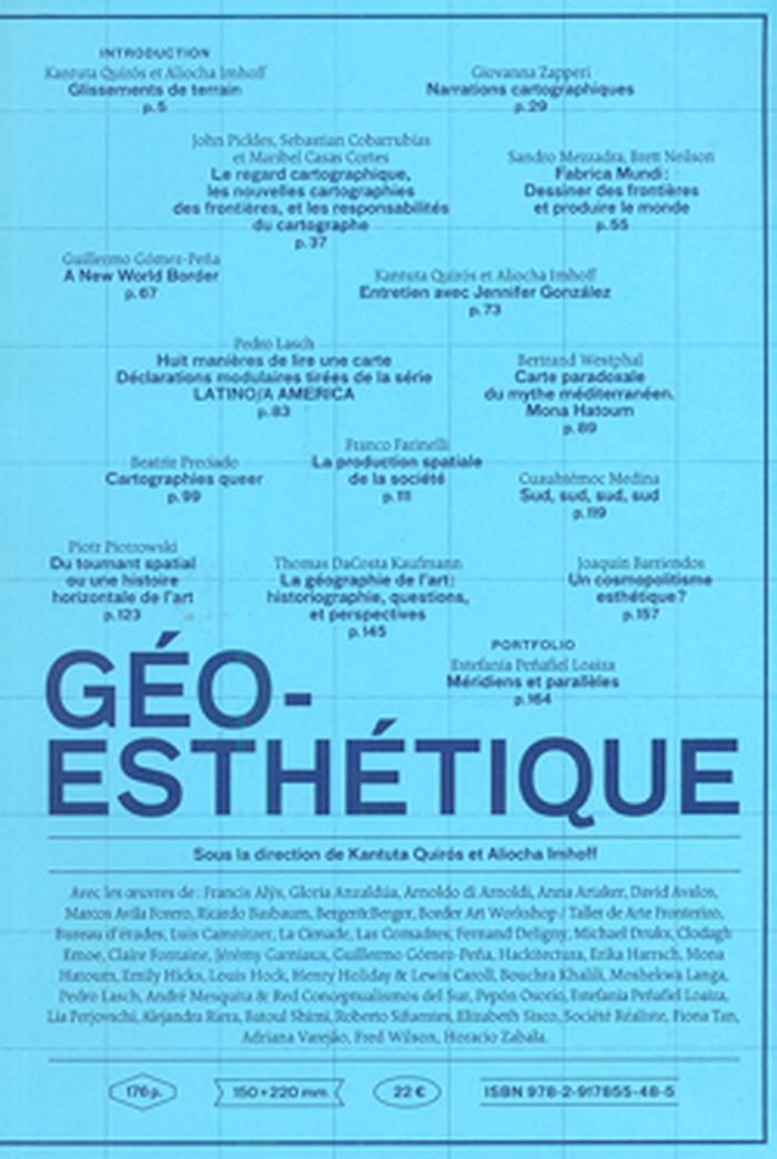
Géoesthétique
Géoesthétique
Actions:
Price:
$41.95
(available to order)
Summary:
À la croisée de courants théoriques tels que la géographie critique et postmoderne, les pensées postcoloniales et décoloniales, Géoesthétique s’intéresse à la figure de l’artiste en géographe, en enquêteur investissant les champs disciplinaires de la géographie et de la cartographie comme terrains d’investigation épistémologique. L’ouvrage mobilise une analyse(...)
Title:
Géoesthétique
Actions:
Price:
$41.95
(available to order)
Summary:
À la croisée de courants théoriques tels que la géographie critique et postmoderne, les pensées postcoloniales et décoloniales, Géoesthétique s’intéresse à la figure de l’artiste en géographe, en enquêteur investissant les champs disciplinaires de la géographie et de la cartographie comme terrains d’investigation épistémologique. L’ouvrage mobilise une analyse «géocritique» étudiant les représentations de l’espace dans les œuvres elles-mêmes, ainsi que celle, indissociable, d’une spatialisation de l’histoire de l’art et du langage curatorial, des contextes spatiaux dans lesquels les œuvres sont produites, circulent et sont valorisées (histoire horizontale de l’art, géohistoire de l’art, pensées de la mondialisation et du décentrement).
Form:
books
books
Publication:
May 2014
May 2014
Subject:
Design Theory
Design Theory
Form:
books
books
Actions:
Holdings:
Description:
xi, 60 pages : illustrations, maps ; 28 cm.
Description:
xi, 60 pages : illustrations, maps ; 28 cm.
Author:
Subject:
Publication:
Chicago : Newberry Library, 1990.
Chicago : Newberry Library, 1990.
Title:
The maps and prints of Paolo Forlani : a descriptive bibliography / David Woodward.
Actions:
Holdings:
Description:
xi, 60 pages : illustrations, maps ; 28 cm.
The maps and prints of Paolo Forlani : a descriptive bibliography / David Woodward.
Actions:
Holdings:
Description:
xi, 60 pages : illustrations, maps ; 28 cm.
Form:
books
books
Publication:
Chicago : Newberry Library, 1990.
Chicago : Newberry Library, 1990.
Author:
Subject:
Form:
maps
maps
Actions:
Holdings:
Description:
1 atlas (vii, 156 pages) : illustrations (chiefly color), color maps ; 31 cm
Description:
1 atlas (vii, 156 pages) : illustrations (chiefly color), color maps ; 31 cm
Author:
Subject:
Publication:
Berkeley : University of California Press, [2010], ©2010
Berkeley : University of California Press, [2010], ©2010
Title:
Infinite city : a San Francisco atlas / by Rebecca Solnit ; with cartographers, Ben Pease, Shizue Seigel.
Actions:
Holdings:
Description:
1 atlas (vii, 156 pages) : illustrations (chiefly color), color maps ; 31 cm
Infinite city : a San Francisco atlas / by Rebecca Solnit ; with cartographers, Ben Pease, Shizue Seigel.
Actions:
Holdings:
Description:
1 atlas (vii, 156 pages) : illustrations (chiefly color), color maps ; 31 cm
Form:
maps
maps
Publication:
Berkeley : University of California Press, [2010], ©2010
Berkeley : University of California Press, [2010], ©2010
Author:
Subject:
Form:
books
books
Actions:
Price:
$37.50
(available to order)
Summary:
"Maps of the imagination" takes us on a magic carpet ride over terrain both familiar and exotic. Using the map as metaphor, Peter Turchi considers writing as a combination of exploration and presentation. He compares the way a writer leads a reader through the imaginary world of a story, novel, or poem to the way a mapmaker charts the physical world. "To ask for a map,"(...)
Title:
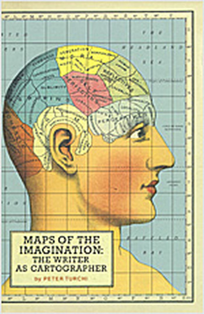
Maps of the imagination : the writer as cartographer
Actions:
Price:
$37.50
(available to order)
Summary:
"Maps of the imagination" takes us on a magic carpet ride over terrain both familiar and exotic. Using the map as metaphor, Peter Turchi considers writing as a combination of exploration and presentation. He compares the way a writer leads a reader through the imaginary world of a story, novel, or poem to the way a mapmaker charts the physical world. "To ask for a map," says Turchi, "is to say, 'Tell me a story.' " The author looks at how mapmakers and writers deal with blank space and the blank page; the conventions they use (both the ones readers recognize and those that often go unnoticed) or consciously disregard; the role of geometry in maps and the parallel role of form in writing; how both maps and writing serve to re-create an individual's view of the world; and the artist's delicate balance of intuition with intention. The ancient Greeks, German globe makers, and British cartographers join forces with the Marx Brothers, NASA, and Roadrunner cartoons to shed light on the strategies of writers as diverse as Sappho, Ernest Hemingway, Virginia Woolf, Vladimir Nabokov, Italo Calvino, Don DeLillo, and Heather McHugh. A combination of history, critical cartography, personal essay, and practical guide to writing, "Maps of the imagination" is a book for writers, for readers, and for anyone interested in creativity.
Form:
books
books
Publication:
October 2004, San Antonio
October 2004, San Antonio
Subject:
Architecture and the imaginary
Architecture and the imaginary
Form:
books
books
Actions:
Holdings:
Description:
117, [3] pages : illustrations ; 16 cm.
Description:
117, [3] pages : illustrations ; 16 cm.
Author:
Subject:
Publication:
[Paris] : Éditions B2, ©2013.
[Paris] : Éditions B2, ©2013.
Title:
Smart cities : théorie et critique d'un idéal auto-réalisateur / Antoine Picon.
Actions:
Holdings:
Description:
117, [3] pages : illustrations ; 16 cm.
Smart cities : théorie et critique d'un idéal auto-réalisateur / Antoine Picon.
Actions:
Holdings:
Description:
117, [3] pages : illustrations ; 16 cm.
Form:
books
books
Publication:
[Paris] : Éditions B2, ©2013.
[Paris] : Éditions B2, ©2013.
Author:
Subject:
Form:
books
books
Actions:
Price:
$57.00
(available to order)
Summary:
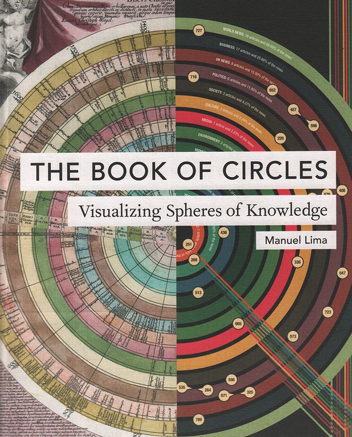
Three hundred detailed and colorful illustrations from around the world cover an encyclopedic array of subjects'architecture, urban planning, fine art, design, fashion, technology, religion, cartography, biology, astronomy, and physics, all based on the circle, the universal symbol of unity, wholeness, infinity, enlightenment, and perfection.
$57.00
(available to order)
Summary:
Three hundred detailed and colorful illustrations from around the world cover an encyclopedic array of subjects'architecture, urban planning, fine art, design, fashion, technology, religion, cartography, biology, astronomy, and physics, all based on the circle, the universal symbol of unity, wholeness, infinity, enlightenment, and perfection.
Title:
The book of circles: visualizing spheres of knowdlege
Actions:
Price:
$57.00
(available to order)
Summary:
Three hundred detailed and colorful illustrations from around the world cover an encyclopedic array of subjects'architecture, urban planning, fine art, design, fashion, technology, religion, cartography, biology, astronomy, and physics, all based on the circle, the universal symbol of unity, wholeness, infinity, enlightenment, and perfection.
Form:
books
books
Publication:
May 2017
May 2017
Form:
books
books
Price:
$11.95
(available to order)
Summary:
Les punks des années 70 ont désormais fait place aux cyberpunks. Eux aussi proclament un "No Future" mais inversé : "Nous avons déjà demain, c'est aujourd'hui que nous voulons." Loin de n'être qu'un sous-genre de la science-fiction, le Cyberpunk est un véritable phénomène culturel. Il essaime dans tous les modes d'expression, de la musique à la bande dessinée en passant(...)
Title:
Cyberpunk
Actions:
Price:
$11.95
(available to order)
Summary:
Les punks des années 70 ont désormais fait place aux cyberpunks. Eux aussi proclament un "No Future" mais inversé : "Nous avons déjà demain, c'est aujourd'hui que nous voulons." Loin de n'être qu'un sous-genre de la science-fiction, le Cyberpunk est un véritable phénomène culturel. Il essaime dans tous les modes d'expression, de la musique à la bande dessinée en passant par le jeu vidéo ou mieux encore le cinéma, où il excelle. Dans cet univers, "le dingue d'informatique et le rocker se rejoignent". Mark Downham cartographie cette nébuleuse en effervescence. Il en dessine l'esthétique et dissèque la genèse du phénomène, en le rapportant à la critique du spectacle de Debord, ici étendue à l'emprise de la technologie sur la vie quotidienne.
Form:
books
books
Publication:
September 2013
September 2013
Subject:
Critical Theory
Critical Theory