3801 Results
Form:
photographs
photographs
Actions:
Reference number:
PH1986:0901:020:001
Description:
- The title of a published identical image to PH1986:0901:020:002, "View of the Imperial Summer Palace, Yuen Ming Yuen, after the Burning, Taken from the Lake, Pekin" is inaccurate, as Yuen Ming Yuen (now Yuanming Yuan) [Garden of Perfect Clarity], though near the Garden of the Clear Ripples [Qing Yi Yuan] (now known as the Summer Palace or Yihe Yuan), is a separate garden complex (Naquin, pp. 312-314).
People:
Subject:
architecture, landscape architecture, topographic
architecture, landscape architecture, topographic
Date:
between 20 October and 2 November 1860
between 20 October and 2 November 1860
Title:
View of the Garden of the Clear Ripples [Qing Yi Yuan] (now known as the Summer Palace or Yihe Yuan), showing Kunming Lake, with Yuquan Shan (also known as Jade Spring Hill) in the background, Peking (now Beijing), China
Actions:
PH1986:0901:020:001
Description:
- The title of a published identical image to PH1986:0901:020:002, "View of the Imperial Summer Palace, Yuen Ming Yuen, after the Burning, Taken from the Lake, Pekin" is inaccurate, as Yuen Ming Yuen (now Yuanming Yuan) [Garden of Perfect Clarity], though near the Garden of the Clear Ripples [Qing Yi Yuan] (now known as the Summer Palace or Yihe Yuan), is a separate garden complex (Naquin, pp. 312-314).
Form:
photographs
photographs
Date:
between 20 October and 2 November 1860
between 20 October and 2 November 1860
People:
Subject:
architecture, landscape architecture, topographic
architecture, landscape architecture, topographic
Form:
photographs
photographs
Actions:
Reference number:
PH1986:0901:040:001
Description:
- This photograph was taken from the base of the White Pagoda [Bai Ta] (now also known as the White Dagoba), Western Garden [Xi Yuan] (now Beihai Park), Peking (now Beijing), China (Harris, p. 147). Jingshan [Hill of Commanding Views] (also known as Coal Hill [Meishan] and Prospect Hill) is visible at upper left, the Ta-kao hsuan Hall (now Dagaoxuan Dian) temple complex is visible from centre left to centre right, and Shengwumen [Gate of Divine Might], the northern gate to the Forbidden City, is visible at extreme centre right.
People:
Subject:
architecture, landscape architecture
architecture, landscape architecture
Date:
after 24 October and before 16 November 1860
after 24 October and before 16 November 1860
Title:
View of Jingshan (also known as Coal Hill or Prospect Hill) and Ta-kao hsuan Hall (now Dagaoxuan Dian) temple complex showing part of the Forbidden City (also known as Zijincheng and the Imperial Palace; now the Palace Museum), Peking (now Beijing), China
Actions:
PH1986:0901:040:001
Description:
- This photograph was taken from the base of the White Pagoda [Bai Ta] (now also known as the White Dagoba), Western Garden [Xi Yuan] (now Beihai Park), Peking (now Beijing), China (Harris, p. 147). Jingshan [Hill of Commanding Views] (also known as Coal Hill [Meishan] and Prospect Hill) is visible at upper left, the Ta-kao hsuan Hall (now Dagaoxuan Dian) temple complex is visible from centre left to centre right, and Shengwumen [Gate of Divine Might], the northern gate to the Forbidden City, is visible at extreme centre right.
Form:
photographs
photographs
Date:
after 24 October and before 16 November 1860
after 24 October and before 16 November 1860
People:
Subject:
architecture, landscape architecture
architecture, landscape architecture
Form:
photographs
photographs
Actions:
Reference number:
PH1986:0901:014:001-003
Description:
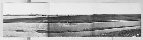
- This panorama is one in a series of views which Felice Beato made of the four Taku Forts (Harris, p. 139; Worswick, p. 138). - This panorama was made from the upper South Taku Fort looking east across the Pei (now Hai) River toward the Gulf of Chihli (now Bo Hai). The British and French combined fleet is visible on the horizon in PH1986:0901:014:002 (Harris, p. 160).
PH1986:0901:014:001-003
Description:
- This panorama is one in a series of views which Felice Beato made of the four Taku Forts (Harris, p. 139; Worswick, p. 138). - This panorama was made from the upper South Taku Fort looking east across the Pei (now Hai) River toward the Gulf of Chihli (now Bo Hai). The British and French combined fleet is visible on the horizon in PH1986:0901:014:002 (Harris, p. 160).
People:
Subject:
architecture, engineering, military, topographic
architecture, engineering, military, topographic
Date:
between 22 August and 21 September 1860
between 22 August and 21 September 1860
Title:
Panorama showing the Pei (now Hai) River delta, with the Lower North Taku Fort (also known as the 2nd North Fort) and the Great South Taku Fort in the background, Taku (now Dagu), near Tientsin (now Tianjin), China
Actions:
PH1986:0901:014:001-003
Description:
- This panorama is one in a series of views which Felice Beato made of the four Taku Forts (Harris, p. 139; Worswick, p. 138). - This panorama was made from the upper South Taku Fort looking east across the Pei (now Hai) River toward the Gulf of Chihli (now Bo Hai). The British and French combined fleet is visible on the horizon in PH1986:0901:014:002 (Harris, p. 160).
Form:
photographs
photographs
Date:
between 22 August and 21 September 1860
between 22 August and 21 September 1860
People:
Subject:
architecture, engineering, military, topographic
architecture, engineering, military, topographic
Form:
photographs
photographs
Actions:
Reference number:
PH1986:0901:015:001
Description:
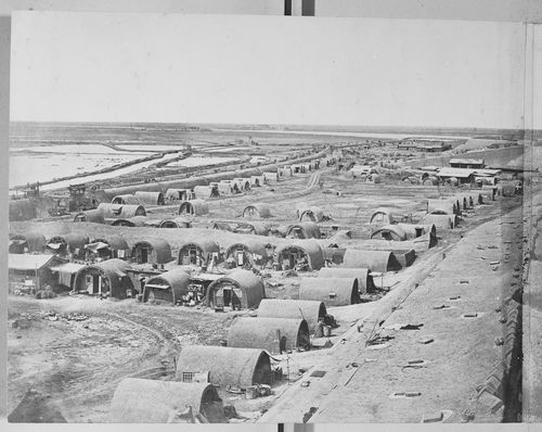
- This photograph is one in a series of views which Felice Beato made of the four Taku Forts (Harris, p. 139; Worswick, p. 138). - This photograph was made from the Great South Taku Fort looking north across the walls of the fort and the Pei (now Hai) River toward the Gulf of Chihli (now Bo Hai) (Harris, p. 143). - A copy print of this panorama under the title "Interior of South Taku Fort and Showing the Place of Landing June 25th 1859" is reproduced in Harris on pages 68-69 (cat. no. 23), and a copy print of PH1986:0901:015:002 (p. 167, fig. 23-3) under the title "Pei-Ho River and Taku Fort II" is reproduced in Harris on p. 167 (fig. 23-3).
PH1986:0901:015:001
Description:
- This photograph is one in a series of views which Felice Beato made of the four Taku Forts (Harris, p. 139; Worswick, p. 138). - This photograph was made from the Great South Taku Fort looking north across the walls of the fort and the Pei (now Hai) River toward the Gulf of Chihli (now Bo Hai) (Harris, p. 143). - A copy print of this panorama under the title "Interior of South Taku Fort and Showing the Place of Landing June 25th 1859" is reproduced in Harris on pages 68-69 (cat. no. 23), and a copy print of PH1986:0901:015:002 (p. 167, fig. 23-3) under the title "Pei-Ho River and Taku Fort II" is reproduced in Harris on p. 167 (fig. 23-3).
People:
Subject:
architecture, engineering, military, topographic
architecture, engineering, military, topographic
Date:
between 22 August and 21 September 1860
between 22 August and 21 September 1860
Title:
View showing part of the Great South Taku Fort and the Pei (now Hai) River delta, with the upper South Taku Fort and the Upper North Taku Fort in the background, Taku (now Dagu), near Tientsin (now Tianjin), China
Actions:
PH1986:0901:015:001
Description:
- This photograph is one in a series of views which Felice Beato made of the four Taku Forts (Harris, p. 139; Worswick, p. 138). - This photograph was made from the Great South Taku Fort looking north across the walls of the fort and the Pei (now Hai) River toward the Gulf of Chihli (now Bo Hai) (Harris, p. 143). - A copy print of this panorama under the title "Interior of South Taku Fort and Showing the Place of Landing June 25th 1859" is reproduced in Harris on pages 68-69 (cat. no. 23), and a copy print of PH1986:0901:015:002 (p. 167, fig. 23-3) under the title "Pei-Ho River and Taku Fort II" is reproduced in Harris on p. 167 (fig. 23-3).
Form:
photographs
photographs
Date:
between 22 August and 21 September 1860
between 22 August and 21 September 1860
People:
Subject:
architecture, engineering, military, topographic
architecture, engineering, military, topographic
Form:
photographs
photographs
Actions:
Reference number:
PH1980:0380:001
Description:
- This photograph is one in a series of views which Felice Beato made of the four Taku Forts (Harris, p. 139; Worswick, p. 138). - This photograph was made from the Great South Taku Fort looking north across the walls of the fort and the Pei (now Hai) River toward the Gulf of Chihli (now Bo Hai) (Harris, p. 143). - A copy print of this panorama under the title "Interior of South Taku Fort and Showing the Place of Landing June 25th 1859" is reproduced in Harris on pages 68-69 (cat. no. 23), and a copy print of PH1980:0380:002 (p. 167, fig. 23-3) under the title "Pei-Ho River and Taku Fort II" is reproduced in Harris on p. 167 (fig. 23-3).
People:
Subject:
architecture, engineering, military, topographic
architecture, engineering, military, topographic
Date:
between 22 August and 21 September 1860
between 22 August and 21 September 1860
Title:
View showing part of the Great South Taku Fort and the Pei (now Hai) River delta, with the upper South Taku Fort and the Upper North Taku Fort in the background, Taku (now Dagu), near Tientsin (now Tianjin), China
Actions:
PH1980:0380:001
Description:
- This photograph is one in a series of views which Felice Beato made of the four Taku Forts (Harris, p. 139; Worswick, p. 138). - This photograph was made from the Great South Taku Fort looking north across the walls of the fort and the Pei (now Hai) River toward the Gulf of Chihli (now Bo Hai) (Harris, p. 143). - A copy print of this panorama under the title "Interior of South Taku Fort and Showing the Place of Landing June 25th 1859" is reproduced in Harris on pages 68-69 (cat. no. 23), and a copy print of PH1980:0380:002 (p. 167, fig. 23-3) under the title "Pei-Ho River and Taku Fort II" is reproduced in Harris on p. 167 (fig. 23-3).
Form:
photographs
photographs
Date:
between 22 August and 21 September 1860
between 22 August and 21 September 1860
People:
Subject:
architecture, engineering, military, topographic
architecture, engineering, military, topographic
Form:
drawings
drawings
Actions:
Reference number:
PH1979:0603.01:012
PH1979:0603.01:012
People:
Subject:
portrait
portrait
Date:
published 1873
published 1873
Title:
Portrait of a seated Chinese woman playing a pipa with a boy behind her
Actions:
PH1979:0603.01:012
Portrait of a seated Chinese woman playing a pipa with a boy behind her
Actions:
PH1979:0603.01:012
Form:
drawings
drawings
Date:
published 1873
published 1873
People:
Subject:
portrait
portrait
Form:
textual records
textual records
Title:
Article about the problems with the Chinese translation of Modern architecture: a critical history
Article about the problems with the Chinese translation of Modern architecture: a critical history
Actions:
Reference number:
AP197.S1.SS4.022
AP197.S1.SS4.022
People:
Date:
1996
1996
Title:
Article about the problems with the Chinese translation of Modern architecture: a critical history
Actions:
AP197.S1.SS4.022
Article about the problems with the Chinese translation of Modern architecture: a critical history
Actions:
AP197.S1.SS4.022
Form:
textual records
textual records
Date:
1996
1996
People:
Form:
photographs
photographs
Actions:
Reference number:
PH1984:1203:048
Description:
- The imprinted label was possibly included after the album was assembled.
PH1984:1203:048
Description:
- The imprinted label was possibly included after the album was assembled.
People:
Subject:
architecture, ornament, sculpture
architecture, ornament, sculpture
Date:
between 1871 and 1874
between 1871 and 1874
Title:
Interior view of Wubai Luohan Tang (also known as Five Hundred Luohans Hall or Five Hundred Arhats Hall) showing Luohans, Hualin Temple (also known as the Temple of the Five Hundred Genii or Gods), Canton (now Guangzhou), China
Actions:
PH1984:1203:048
Description:
- The imprinted label was possibly included after the album was assembled.
Form:
photographs
photographs
Date:
between 1871 and 1874
between 1871 and 1874
People:
Subject:
architecture, ornament, sculpture
architecture, ornament, sculpture
Form:
photographs
photographs
Actions:
Reference number:
PH1984:1203:045
PH1984:1203:045
People:
Subject:
architecture, sculpture
architecture, sculpture
Date:
1887 or before
1887 or before
Form:
photographs
photographs
Date:
1887 or before
1887 or before
People:
Subject:
architecture, sculpture
architecture, sculpture
Form:
photographs
photographs
![Panoramic view of a section of the Imperial City showing Jade Flowery Island [Qionghua Dao], the White Pagoda [Bai Ta], part of North Lake [Beihai] and other structures in the Western Garden (now Beihai Park), Peking (now Beijing), China](/img-collection/Ff4oUOqv3xykwxhxV0teYbF2k9s=/500x391/13873.jpg)
Actions:
Reference number:
PH1986:0901:039
Description:
- This photograph was taken from the top of Jingshan [Hill of Commanding Views] (also known as Coal Hill [Meishan] and Prospect Hill) looking northwest. - At the time the photo was taken, the North Lake [Beihai], which is visible at centre right, had been drained (Harris, p. 148). The East Gate to Western Garden [Xi Yuan] (now Beihai Park) is visible slightly left of centre and the conical roofed building at centre left is the northern-most building within the Daoist Ta-kao hsuan Hall (now Dagaoxuan Dian) temple complex.
People:
Subject:
architecture, landscape architecture, topographic
architecture, landscape architecture, topographic
Date:
29 October 1860
29 October 1860
Title:
Panoramic view of a section of the Imperial City showing Jade Flowery Island [Qionghua Dao], the White Pagoda [Bai Ta], part of North Lake [Beihai] and other structures in the Western Garden (now Beihai Park), Peking (now Beijing), China
Actions:
PH1986:0901:039
Description:
- This photograph was taken from the top of Jingshan [Hill of Commanding Views] (also known as Coal Hill [Meishan] and Prospect Hill) looking northwest. - At the time the photo was taken, the North Lake [Beihai], which is visible at centre right, had been drained (Harris, p. 148). The East Gate to Western Garden [Xi Yuan] (now Beihai Park) is visible slightly left of centre and the conical roofed building at centre left is the northern-most building within the Daoist Ta-kao hsuan Hall (now Dagaoxuan Dian) temple complex.
Form:
photographs
photographs
Date:
29 October 1860
29 October 1860
People:
Subject:
architecture, landscape architecture, topographic
architecture, landscape architecture, topographic