755 Results
Level of archival description:
Project
Project
Actions:
Reference number:
AP018.S1.1976.PR17
Description:
This project series documents the site planning for the Gordie Howe Sports Complex project, Mississauga, Ontario, between Dixie Road, Aerowood Drive and the Highway 401. This project was first known as Mississauga Sports Complex at the beginning of the project from 1973-1974, but later became the Gordie Howe Sports Centre in 1975. The office identified the project number as 7614. The project consisted of a group of buildings including a tennis court, an arena, and a interior jogging track. The project is recorded through correspondence with clients, consultants and contractors, and meeting reports dating from 1976-1977.
People:
Date:
1976-1977
1976-1977
Title:
Gordie Howe Sports Centre, Site Planning, Mississauga, Ontario (1976-1977)
Actions:
AP018.S1.1976.PR17
Description:
This project series documents the site planning for the Gordie Howe Sports Complex project, Mississauga, Ontario, between Dixie Road, Aerowood Drive and the Highway 401. This project was first known as Mississauga Sports Complex at the beginning of the project from 1973-1974, but later became the Gordie Howe Sports Centre in 1975. The office identified the project number as 7614. The project consisted of a group of buildings including a tennis court, an arena, and a interior jogging track. The project is recorded through correspondence with clients, consultants and contractors, and meeting reports dating from 1976-1977.
Level of archival description:
Project
Project
Date:
1976-1977
1976-1977
People:
Level of archival description:
Project
Project
Reference number:
AP148.S1.1969.PR01
Description:
This project series features drawings and text, as well as collages on photographs, for a project entitled "Breve racconto di Architettura" by Poli. An inventory provided by Poli was used to identify the dates of these materials. The drawings and text seem to feature a journey on a highway (autostrada), or by plane, as all of the collaged images seem to be views taken from an airplane. These collages feature images of food and structures glued onto images of both rural and urban landscapes. References are made in the text to the Parco urbano Modena, possibly related to Poli's thesis project (see AP148.S1.1970.PR01), as well as to Roland Barthes, and "architettura invisibile".
People:
Date:
ca. 1969-1970
ca. 1969-1970
Title:
Breve racconto di Architettura [Brief tale of architecture] (1969-1970)
Actions:
AP148.S1.1969.PR01
Description:
This project series features drawings and text, as well as collages on photographs, for a project entitled "Breve racconto di Architettura" by Poli. An inventory provided by Poli was used to identify the dates of these materials. The drawings and text seem to feature a journey on a highway (autostrada), or by plane, as all of the collaged images seem to be views taken from an airplane. These collages feature images of food and structures glued onto images of both rural and urban landscapes. References are made in the text to the Parco urbano Modena, possibly related to Poli's thesis project (see AP148.S1.1970.PR01), as well as to Roland Barthes, and "architettura invisibile".
Level of archival description:
Project
Project
Date:
ca. 1969-1970
ca. 1969-1970
People:
Level of archival description:
Project
Project
Title:
Berlin
Berlin
Reference number:
AP144.S2.D161
Description:
File documents Price's participation in a design workshop to develop highly energy-efficient office buildings for seven sites in Berlin, Germany. Price's team's site was an unused, elevated stretch of highway. The designs resulting from the workshop were displayed in an exhibition entitled "Wohltemperierte Architektur: Konzepte für Energiesparende Bürogebäude" (English: "Welltempered Architecture: Concepts for Green Office Buildings"), held in May 1992 at the Aedes Galerie in Berlin. Material in this file was produced in 1992. Project designed by a team composed of Cedric Price, Max Fordham, Almut Ernst, Katharina von Ehren, Christopher McCarthy and 12 students. File contains conceptual drawings, photographs and textual records.
People:
Date:
1992
1992
Title:
Berlin
Actions:
AP144.S2.D161
Description:
File documents Price's participation in a design workshop to develop highly energy-efficient office buildings for seven sites in Berlin, Germany. Price's team's site was an unused, elevated stretch of highway. The designs resulting from the workshop were displayed in an exhibition entitled "Wohltemperierte Architektur: Konzepte für Energiesparende Bürogebäude" (English: "Welltempered Architecture: Concepts for Green Office Buildings"), held in May 1992 at the Aedes Galerie in Berlin. Material in this file was produced in 1992. Project designed by a team composed of Cedric Price, Max Fordham, Almut Ernst, Katharina von Ehren, Christopher McCarthy and 12 students. File contains conceptual drawings, photographs and textual records.
Level of archival description:
File 161
File 161
Date:
1992
1992
People:
Form:
drawings
drawings
Reference number:
AP148.S1.1970.PR02.001.1
Description:
The material in the next 7 files (AP148.S1.1970.PR02.001.1 through AP148.S1.1970.PR02.001.7) was contained together in a handmade folder titled "AI Storyboard". The material in this folder has been separated for preservation purposes, and the original folder has been retained. This file contains notes and sketches on the film idea, including the story, visuals, music and cinematography. Also includes clippings, both of which refer to imagery and ideas of an earth-moon highway or contest for a highway, as well as the first architectural competition in space ("Primo concorso di architettura nello spazio"). Also includes a small viewer of an Escher image.
People:
Date:
ca. 1970-1971
ca. 1970-1971
Title:
Notes and sketches on a film story, Interplanetary Architecture (Folder 1 of 7)
Actions:
AP148.S1.1970.PR02.001.1
Description:
The material in the next 7 files (AP148.S1.1970.PR02.001.1 through AP148.S1.1970.PR02.001.7) was contained together in a handmade folder titled "AI Storyboard". The material in this folder has been separated for preservation purposes, and the original folder has been retained. This file contains notes and sketches on the film idea, including the story, visuals, music and cinematography. Also includes clippings, both of which refer to imagery and ideas of an earth-moon highway or contest for a highway, as well as the first architectural competition in space ("Primo concorso di architettura nello spazio"). Also includes a small viewer of an Escher image.
Form:
drawings
drawings
Date:
ca. 1970-1971
ca. 1970-1971
People:
Level of archival description:
Project
Project
Actions:
Reference number:
AP018.S1.1973.PR06
Description:
This project series documents a proposal for an athletic, cultural and industrial campus in Mississauga, Ontario, between Dixie Road, Aerowood Drive and the Highway 401. This project was known as Mississauga Sports Complex at the beginning of the project from 1973-1974, but later became the Gordie Howe Sports Centre in 1975. The office identified the project number as 7306. The project consisted of a group of buildings including a tennis court, an arena, and a interior jogging track. The project is recorded through drawings and textual records dating from 1973-1976. The majority of the drawings are originals that show site plans, floor plans, elevations, sections, and structural drawings. Textual records include correspondence with clients and consultants as well as conference reports.
People:
Date:
1973-1976
1973-1976
Title:
Gordie Howe Sports Centre, Mississauga, Ontario (1973-1976)
Actions:
AP018.S1.1973.PR06
Description:
This project series documents a proposal for an athletic, cultural and industrial campus in Mississauga, Ontario, between Dixie Road, Aerowood Drive and the Highway 401. This project was known as Mississauga Sports Complex at the beginning of the project from 1973-1974, but later became the Gordie Howe Sports Centre in 1975. The office identified the project number as 7306. The project consisted of a group of buildings including a tennis court, an arena, and a interior jogging track. The project is recorded through drawings and textual records dating from 1973-1976. The majority of the drawings are originals that show site plans, floor plans, elevations, sections, and structural drawings. Textual records include correspondence with clients and consultants as well as conference reports.
Level of archival description:
Project
Project
Date:
1973-1976
1973-1976
People:
Level of archival description:
Project
Project
Actions:
Reference number:
AP018.S1.1976.PR09
Description:
This project series documents the schematic design for the Gordie Howe Sports Complex in Mississauga, Ontario, between Dixie Road, Aerowood Drive and the Highway 401 from 1976-1979. The office identified this project as 7614. This project was first known as Mississauga Sports Complex at the beginning of the project from 1973-1974, but later became the Gordie Howe Sports Centre in 1975. The office identified the project number as 7429. The project consisted of a group of buildings including a tennis court, an arena, and a interior jogging track. The project is recorded through drawings and some textual records dating from 1976-1979. The majority of the drawings are reprographic copies that show site plans, floor plans, elevations, and sections. Textual records include correspondence and meeting reports.
People:
Date:
1976-1979
1976-1979
Title:
Gordie Howe Sports Centre, Schematic Design, Missisauga, Ontario (1976-1979)
Actions:
AP018.S1.1976.PR09
Description:
This project series documents the schematic design for the Gordie Howe Sports Complex in Mississauga, Ontario, between Dixie Road, Aerowood Drive and the Highway 401 from 1976-1979. The office identified this project as 7614. This project was first known as Mississauga Sports Complex at the beginning of the project from 1973-1974, but later became the Gordie Howe Sports Centre in 1975. The office identified the project number as 7429. The project consisted of a group of buildings including a tennis court, an arena, and a interior jogging track. The project is recorded through drawings and some textual records dating from 1976-1979. The majority of the drawings are reprographic copies that show site plans, floor plans, elevations, and sections. Textual records include correspondence and meeting reports.
Level of archival description:
Project
Project
Date:
1976-1979
1976-1979
People:
Form:
drawings
drawings
Actions:
Reference number:
DR1987:0693
Description:
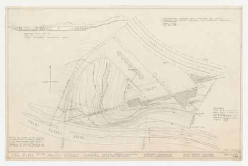
- This block plan for Wayfarers' Chapel, Palos Verdes, California, includes the new highway and shows the rectory and the triangular-plan parish house, neither of which were built. - The survey information on drawing DR1987:0693 appears to be copied by Kazio from an April 1949 survey by Charles C. Miller (probably DR1987:0679 or DR1987:0677).
DR1987:0693
Description:
- This block plan for Wayfarers' Chapel, Palos Verdes, California, includes the new highway and shows the rectory and the triangular-plan parish house, neither of which were built. - The survey information on drawing DR1987:0693 appears to be copied by Kazio from an April 1949 survey by Charles C. Miller (probably DR1987:0679 or DR1987:0677).
People:
Subject:
architecture, topographic
architecture, topographic
Date:
2 September 1954, revised 1 May 1956
2 September 1954, revised 1 May 1956
Title:
Wayfarers' Chapel, Palos Verdes, California: Site plan based on a topographic survey, with section through entrance steps showing gateway
Actions:
DR1987:0693
Description:
- This block plan for Wayfarers' Chapel, Palos Verdes, California, includes the new highway and shows the rectory and the triangular-plan parish house, neither of which were built. - The survey information on drawing DR1987:0693 appears to be copied by Kazio from an April 1949 survey by Charles C. Miller (probably DR1987:0679 or DR1987:0677).
Form:
drawings
drawings
Date:
2 September 1954, revised 1 May 1956
2 September 1954, revised 1 May 1956
People:
Subject:
architecture, topographic
architecture, topographic
Form:
events
events

Actions:
Keyword(s):
Visiting Scholar, Christine Macy, Flows as Agents of Transformation, From Wastelands to Wonderlands, Wasteland, “townless highway”, Benton MacKaye, Tennessee Valley Authority, Norris Dam project
Visiting Scholar, Christine Macy, Flows as Agents of Transformation, From Wastelands to Wonderlands, Wasteland, “townless highway”, Benton MacKaye, Tennessee Valley Authority, Norris Dam project
Date:
21 August 2008
21 August 2008
Form:
events
events
Date:
21 August 2008
21 August 2008
Level of archival description:
Project
Project
Reference number:
AP148.S1.1988.PR02
Description:
Project series comprises material related to a design entry for a 1988 competition on the environmental redevelopment of the San Carlo quarry in the comune of Castelnuovo Berardenga near Siena, Italy. Poli dates this project as 1988, though most of the material is undated (only 2 drawings are dated 1988). However, the project description text includes a bibliography making reference to 1991 publications, though it is possible that this document was created later than the drawings. Project material includes numerous drawings and collages, some which are overlayed with wax, one which features a metal object, and some drawn directly onto topographical maps. Project material also includes a model, a photomontage featuring images of the quarry site and geological strata, and a typed project description. Parts of the text in the project description also appear on some of the drawings. Many of the drawings feature a circular design that is repeated throughout the drawing material in this series. Poli's proposal for the redevelopment seemed to involve the addition of trees to the area and the development of a passageway. One of Poli's drawings makes reference to the earth moon highway featured in an earlier project, Interplanetary Architecture (see AP148.S1.1970.PR02).
People:
Date:
1988
1988
Title:
Ideas competition, Riqualificazione cava di San Carlo [Redevelopment San Carlo quarry], San Vincenzo, Livorno, Italy (1988)
Actions:
AP148.S1.1988.PR02
Description:
Project series comprises material related to a design entry for a 1988 competition on the environmental redevelopment of the San Carlo quarry in the comune of Castelnuovo Berardenga near Siena, Italy. Poli dates this project as 1988, though most of the material is undated (only 2 drawings are dated 1988). However, the project description text includes a bibliography making reference to 1991 publications, though it is possible that this document was created later than the drawings. Project material includes numerous drawings and collages, some which are overlayed with wax, one which features a metal object, and some drawn directly onto topographical maps. Project material also includes a model, a photomontage featuring images of the quarry site and geological strata, and a typed project description. Parts of the text in the project description also appear on some of the drawings. Many of the drawings feature a circular design that is repeated throughout the drawing material in this series. Poli's proposal for the redevelopment seemed to involve the addition of trees to the area and the development of a passageway. One of Poli's drawings makes reference to the earth moon highway featured in an earlier project, Interplanetary Architecture (see AP148.S1.1970.PR02).
Level of archival description:
Project
Project
Date:
1988
1988
People:
Level of archival description:
Project
Project
Actions:
Reference number:
AP056.S1.1991.PR03
Description:
This project series documents planning for the Westnor Development Project, later called Wittington Place, in North York, Ontario from 1991-1997. The office identified the project number as 9106. This project consisted of a competition entry to develop the area above Highway 401 next to Yonge Street. The large plot of land would be a mix of residential, retail, hotel, office and outdoor spaces. The competition also called for the creation of a sports arena, Canada Coliseum, to be used for professional basketball and hockey. This entry was proposed by New York based firm Ehrenkrantz Eckstut and Whitelaw Architects, working with KPMB, among others.[1] The development was to be carried out in multiple phases, divided by city blocks. The drawings present different schemes for this development, most of which include a large park at its centre. This project was never built. The project is recorded through drawings and a site plan painting dating from 1991-1997. The large part of these drawings are originals and include sketches, model drawings, site plans and surveys, elevations, sections, perspectives and axonometric drawings. These drawings focus primarily on the development of the area as a whole and less on individual buildings. [1] Mark Osbaldeston, Unbuilt Toronto 2: More of the City That Might Have Been (Toronto: Dundurn Press, 2001), 160.
People:
Date:
1991-1997
1991-1997
Title:
The Westnor Development Project, North York, Ontario (1991-1997)
Actions:
AP056.S1.1991.PR03
Description:
This project series documents planning for the Westnor Development Project, later called Wittington Place, in North York, Ontario from 1991-1997. The office identified the project number as 9106. This project consisted of a competition entry to develop the area above Highway 401 next to Yonge Street. The large plot of land would be a mix of residential, retail, hotel, office and outdoor spaces. The competition also called for the creation of a sports arena, Canada Coliseum, to be used for professional basketball and hockey. This entry was proposed by New York based firm Ehrenkrantz Eckstut and Whitelaw Architects, working with KPMB, among others.[1] The development was to be carried out in multiple phases, divided by city blocks. The drawings present different schemes for this development, most of which include a large park at its centre. This project was never built. The project is recorded through drawings and a site plan painting dating from 1991-1997. The large part of these drawings are originals and include sketches, model drawings, site plans and surveys, elevations, sections, perspectives and axonometric drawings. These drawings focus primarily on the development of the area as a whole and less on individual buildings. [1] Mark Osbaldeston, Unbuilt Toronto 2: More of the City That Might Have Been (Toronto: Dundurn Press, 2001), 160.
Level of archival description:
Project
Project
Date:
1991-1997
1991-1997
People: