


Limits to Dataland
Ben Clark, Dimitris Hartonas, Piergianna Mazzocca, Giuditta Tranni, and Katrin Zavgorodny-Freedman
The following text introduces the first five articles produced by participants in the 2025 Toolkit for Today: Computation is the New Optics. Drawing on Felicity Scott’s concept of “dataland” from Outlaw Territories, this collective statement by Ben Clark, Dimitris Hartonas, Piergianna Mazzocca, Giuditta Tranni, and Katrin Zavgorodny-Freedman traces how architecture has long been entangled with infrastructures that circulate knowledge. Informed by CCA Collection, the five short essays trace data across colonial networks, oceans, oil fields, sound waves, and construction sites, revealing how systems of information have shaped the built environment on a global scale.
Collective Statement
Felicity Scott’s 2016 book Outlaw Territories dedicates a chapter to early research and experimentation with spatial data management by MIT’s Architecture Machine Group (ArcMac) in the late 1970s. In the chapter, Scott deploys the term “dataland,” a conceptual space where architecture intertwines with information systems, knowledge infrastructures, and access regimes. From Scott’s perspective, the use of spatial data management marks a significant shift in architectural history, as it recognizes how spatial expertise, combined with computational information systems, is leveraged to create spaces defined and bounded by vast collections of data. Considering the military and surveillance applications of dataland, the chapter calls attention to the ArcMac project’s involvement in the management of “insecure territories and unsettled populations,” showing how information systems and data collection are dependent on infrastructural and ideological support systems involved in the production of knowledge.1 Dataland, by this approximation, becomes a site where power is exercised through data systems and where the limits of knowledge become apparent.
Compelled to think with Scott’s dataland as new computational optics expand the scope of architectural history inquiry, the short essays presented here explore how our architectural field is influenced by the material, technical, and epistemological infrastructures that collect, classify, and disseminate knowledge.2 Drawing heavily from materials in the Canadian Centre for Architecture archives, the contributions here analyze how information has been collected, represented, and preserved throughout various historical periods. They investigate dissemination infrastructures in a broad sense, covering everything from media technologies to water transportation systems, and consider how these systems shape their audiences and define interpretative possibilities. Notably, these infrastructures have continuously operated on an international scale, connecting individuals, institutions, and technologies across national borders. Whether through the distribution of architectural periodicals, the circulation of building manuals, or the transnational collection of sounds, images, and surveys, dataland is portrayed as a field built through exchanges that extend beyond a single nation or archive.
The essays also pay attention to how individuals experience navigating dataland—how different subjects encounter, resist, or reshape the architecture of information. In this context, Scott’s focus on security and “knowing the other” is particularly relevant, as data emerges as a contested domain of access, exclusion, and surveillance rather than a neutral substrate.
We aim to highlight both the historical conditions that made dataland possible—practices such as surveying, accounting, and collecting intended to make the world understandable—and the contemporary actions that strive to hack, reroute, or disrupt these very practices. By considering architecture within its international data infrastructures, this collection not only identifies the limitations of computational optics but also imagines how architectural historians might engage differently with the landscape of dataland.
Ben Clark
Felicity Scott’s Outlaw Territories also included a chapter on what she terms “Third World Games,” in which she examines the ambiguities and controversies that emerged around the UN Habitat I Conference held in Vancouver in 1976.1 Her title deliberately echoes Richard Buckminster Fuller’s “World Peace Game,” a series of computer-aided simulation workshops developed in the late 1960s that encouraged participants to collaborate using large-scale official datasets (for instance, United States government publications or United Nations reports) to address environmental and socio-economic problems on a planetary scale by framing them entirely as questions of resource management. As Scott argues, Fuller’s “Game” and the Declaration of the Vancouver Symposium (1976), through their shared pursuit of “new and appropriate methods of collecting and organizing data,” both reframed the “Third World” as a problem of information rather than politics.
The Georg Lippsmeier archives held at the CCA, relating to the Institut für Tropenbau (Institute for Building in the Tropics, IFT) he founded in Germany in 1969, reveal an institution structured around a comparable conviction that the so-called “Third World problem” could be approached primarily as a matter of better information flows, namely their collection, standardization, circulation, and comparison.3 Architects were no longer positioned solely as designers of buildings, but as producers and organizers of data, tasked with indexing case studies, writing comparative reports, assembling centralized libraries, compiling photographic collections, etc. Lippsmeier’s archives thus appeared particularly valuable not because they documented the IFT’s built projects, but because they made visible (post)colonial global networks and flows of knowledge on “tropical architecture” and development-oriented architecture. The corpus largely consisted of “bulletins,” “notes,” and “information sheets,” documenting the use of appropriate technologies and prefabrication systems for low-cost housing, linking research centres in Ghana, Kenya, South Africa, and India with counterparts in Europe and North America.
-
Scott, Felicity D. Outlaw Territories: Environments of Insecurity/Architecture of Counterinsurgency. Princeton University Press, 2016. ↩
-
Vancouver Symposium, “Declaration,” pp. 271-272, cited by Scott, Outlaw Territories, op.cit. (refer to the subchapter “Architectures of Management”). ↩
-
Lee, Rachel, and Monika Motylińska. “Essential Reading? The Institut Für Tropenbau’s Publications as Primers for the Design-Build Movement.” In Design Building Postcolonial Contexts: A Critical Interrogation, Sto Foundation, by Vera Simone Bader. 2024. ↩
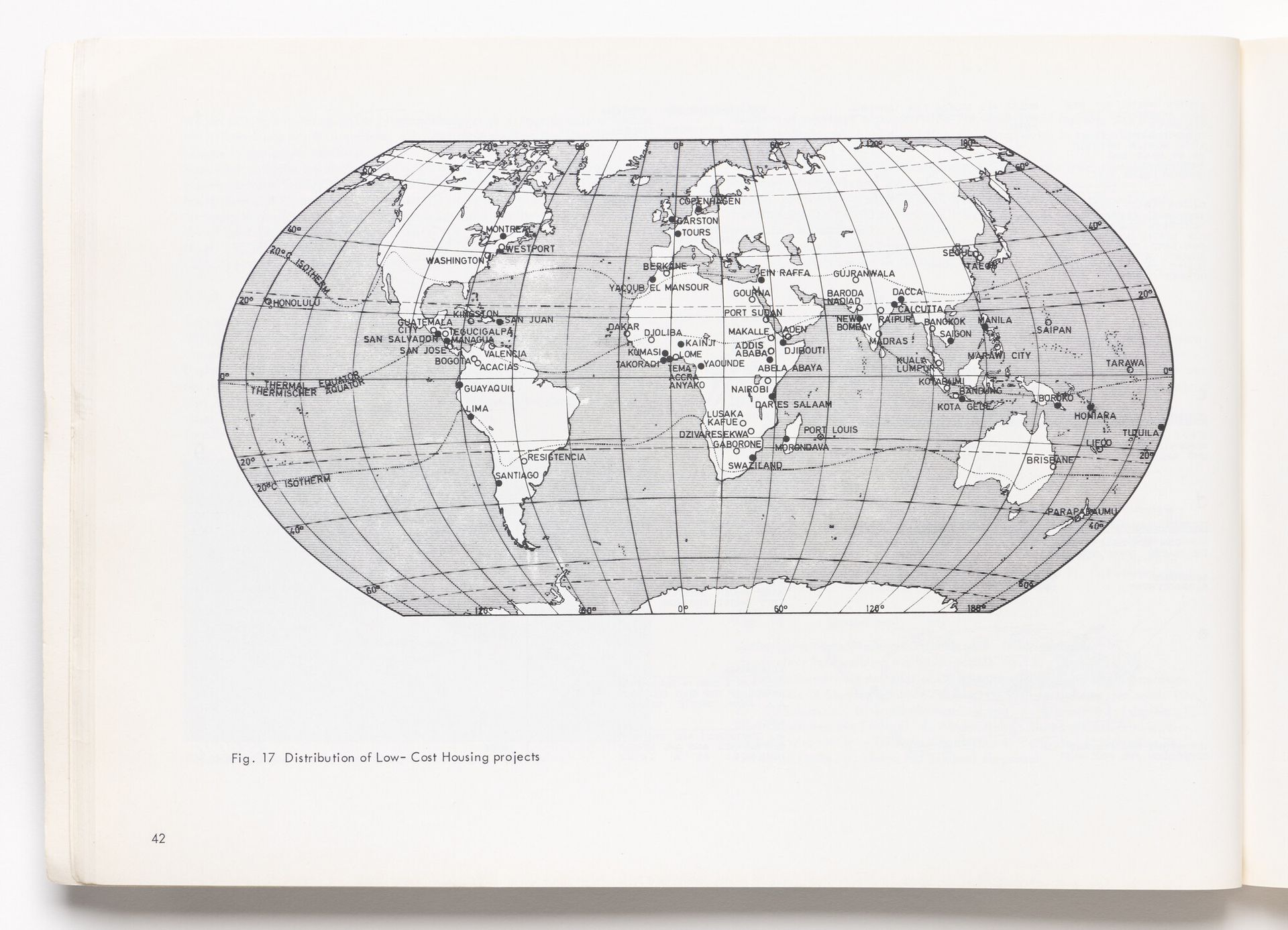
Distribution of Low-Cost Housing projects. Mukerii, K., Sulejman-Pasic, N., Murison, H.S. and Hockings, J.E., 1975, Prefabricatlon for Low-Cost Housing in Tropical Areas, Starnberg: Institut für Tropenbau, Report n°4, p.42. © CCA
Taking Lippsmeier’s archives as an opportunity to retrace what might be called a global “Third World dataland,” I suggest that they can help historians situate, and critically reinterrogate, other research centres operating in different contexts, and clarify the place they did, or did not, occupy within this dataland. For example, the brief history of the Centre d’Expérimentation, de Recherche et de Formation (CERF, 1967–72), a Moroccan public institute that I have been studying as part of my doctoral research, could be revisited through IFT-related archives as a way of moving beyond a purely national historical frame.1 This archival cross-reading became unexpectedly concrete when I encountered in the CCA archives the world map published in the fourth IFT report (1975), “Prefabrication for Low-Cost Housing in Tropical Areas,” which plotted eighty-eight low-cost housing projects worldwide, including two sites in Morocco that were in fact projects led by the CERF. One was the well-known experiment led by the French Hungarian engineer David George Emmerich in Yacoub el Mansour (Rabat), where light reed constructions—in a very Buckminster Fuller-type way—were tested during summer workshops as part of a search for low-cost housing intended to replace slums. This project, already well documented at the time in Morocco and in France, was therefore unsurprisingly referenced and illustrated in the IFT report.2
-
Clark, Ben. 2025. “Soft, Slow, and Low-Cost Architecture: CERF’s Foreign Experts in Morocco (1967-1972).” ABE Journal. Architecture beyond Europe, no. 25 (July). https://doi.org/10.4000/14vh7 ↩
-
Bauer, Gérard, and Jean Dethier. 1972. “La Terre et Le Roseau: Ou La Réhabilitation et l’amélioration de Techniques Traditionnelles de Construction Au Maroc.” L’Architecture d’Aujourd’hui, no. 160 (February): 104–11. ↩
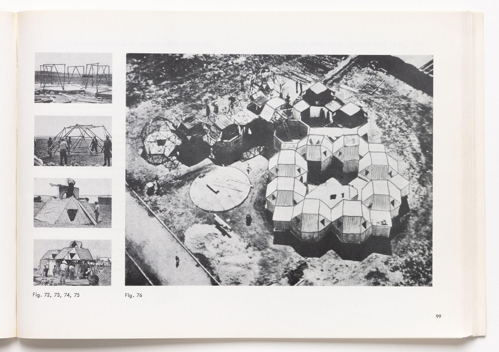
Self-aid housing experimental project in Yacoub el Mansour, Rabat, Morocco, Mukerii, K., Sulejman-Pasic, N., Murison, H.S. and Hockings, J.E., 1975. Prefabricatlon for Low-Cost Housing in Tropical Areas, Starnberg: Institut für Tropenbau, Report n°4, p.99. © CCA
The other Moroccan case, the new village of Berkane, is described in the literature as a rural, state-led project supported by the United Nations World Food Programme, but Lippsmeier’s archives allowed it to be repositioned within circuits of knowledge whose visibility depended on its use of asbestos-cement roofing.1 The project indeed appeared in a 1970 issue of the International Asbestos-Cement Review, co-edited by Georg Lippsmeier himself (together with Robin Atkinson, Lucien Kroll, and Juan José Rodríguez), and devoted to “Housing for so-called developing countries.”2 3 In this configuration, Berkane seemed to have entered the circulation of reference not through the authorship of a celebrated architect or engineer, but through the low-cost prefabrication technique it used and through regimes of visibility produced by industry-linked architectural journals.
-
Rouizem, Nadya. 2022. Réinventer La Terre Crue. Expérimentations Au Maroc Depuis 1960. Éditions Recherche. ↩
-
On the importance of this journal, which Hannah le Roux describes as “the first truly global architectural journal”, refer to: Le Roux, Hannah. Circulating Asbestos: The International AC Review, 1956-1985. Montréal: Canadian Centre for Architecture, 2022. ↩
-
“Berkane (Morocco) : An Experimental Settlement; Une Cité Expérimentale,” International asbestos-cement review, no. 58 (April 1970): 16–17. ↩
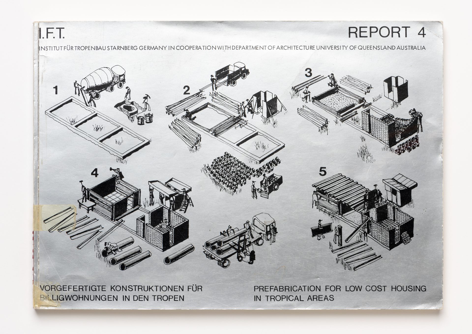
Report cover, Mukerii, K., Sulejman-Pasic, N., Murison, H.S. and Hockings, J.E., 1975. Prefabricatlon for Low-Cost Housing in Tropical Areas, Starnberg: Institut für Tropenbau, Report n°4. © CCA
The question of how to operate, as a historian, within such a “Third World dataland” remained deliberately open. Yet, if one followed the computational metaphor, it became possible to ask, following Hannah le Roux and Viviana d’Auria, how it might be “hacked,” and how this large amount of data on development-oriented architecture produced in the second half of the twentieth century could be critically reread.1 One way of doing so, as I suggested here, might be to compare and cross-read documentation produced by research centres operating in different contexts, whose networks nonetheless intersected, thereby bringing to light the channels through which references and actors circulated and through which this “Third World dataland” was constructed globally.
-
Le Roux, Hannah, and Viviana d’Auria. “Appropriating Aid and Its Multiple Histories.” ABE Journal. Architecture beyond Europe, no. 22 (December 2023): 22. https://doi.org/10.4000/abe.15369 ↩
Dimitris Hartonas
For the most part, data is waterborne. This is not only because its ebbs and flows through global networks inscribe it in liquid hermeneutics, nor because it constitutes a metaphorical sea of information whose atomizing would incur the same effect as extracting a glass of seawater from the ocean. Rather, data is reliably waterborne in strictly material terms. The very infrastructure of cables, through which the worldmaking circulation of data takes place, has been for some time now entrusted to the bottom of the ocean and allowed to surface only at its edges.1 So, while Scott’s sharply delineated data-land implies a terrafirma, the domain through which land becomes defined and bounded by data remains distinctly aqueous—a data-sea undergirding dataland.
This information waterscape runs through the CCA’s Collection, though—true to form—it often stays hidden beneath the surface of photographic emulsions. PH1981:0589, an album titled “Views of the Middle and Far East, and India,” is a case in point. Whoever compiled it left no trace on either the album or acquisition records, which makes its peculiar assembly of photographic prints, taken in the 1860s by authors ranging from celebrated British photographer Samuel Bourne to tea merchant and amateur lensman Donald Horne Macfarlane, even more puzzling. Its seventy-six prints of, inter alia, buildings, landscapes, shipwrecks, rocks, a carpenter, the King of Semarang, harbours, a band of musicians, and a waterfall depict locations in India (Calcutta, Delhi), Myanmar (Rangoon), Singapore, Indonesia (Java), and Egypt (Suez). Yet, despite its multivalence, the album rehearses a story of aqueous networks: of shipborne mobility and telegraph cables. Amongst its last two prints, both of Suez and both likely taken by Justin Kozlowski, is a photograph of a street in the town of Suez. The street in question is framed by the port in the background, an open-air structure on the right-hand side and, importantly, a Telegraph building on the left. When viewed closely, and under a magnifying glass, the sign on the building advertises that inside one can transmit signals to “Alexandria Cairo & Suez” as well as through “the Malta & Alexandria Telegraph to Europe.”
-
Andrew Blum, Tubes: A Journey to the Center of the Internet, 1st ed. (New York: Ecco, 2012); Bruce J. Hunt, Imperial Science: Cable Telegraphy and Electrical Physics in the Victorian British Empire (Cambridge: Cambridge University Press, 2021); Starosielski, Nicole, The Undersea Network (Durham: Duke University Press, 2015). ↩
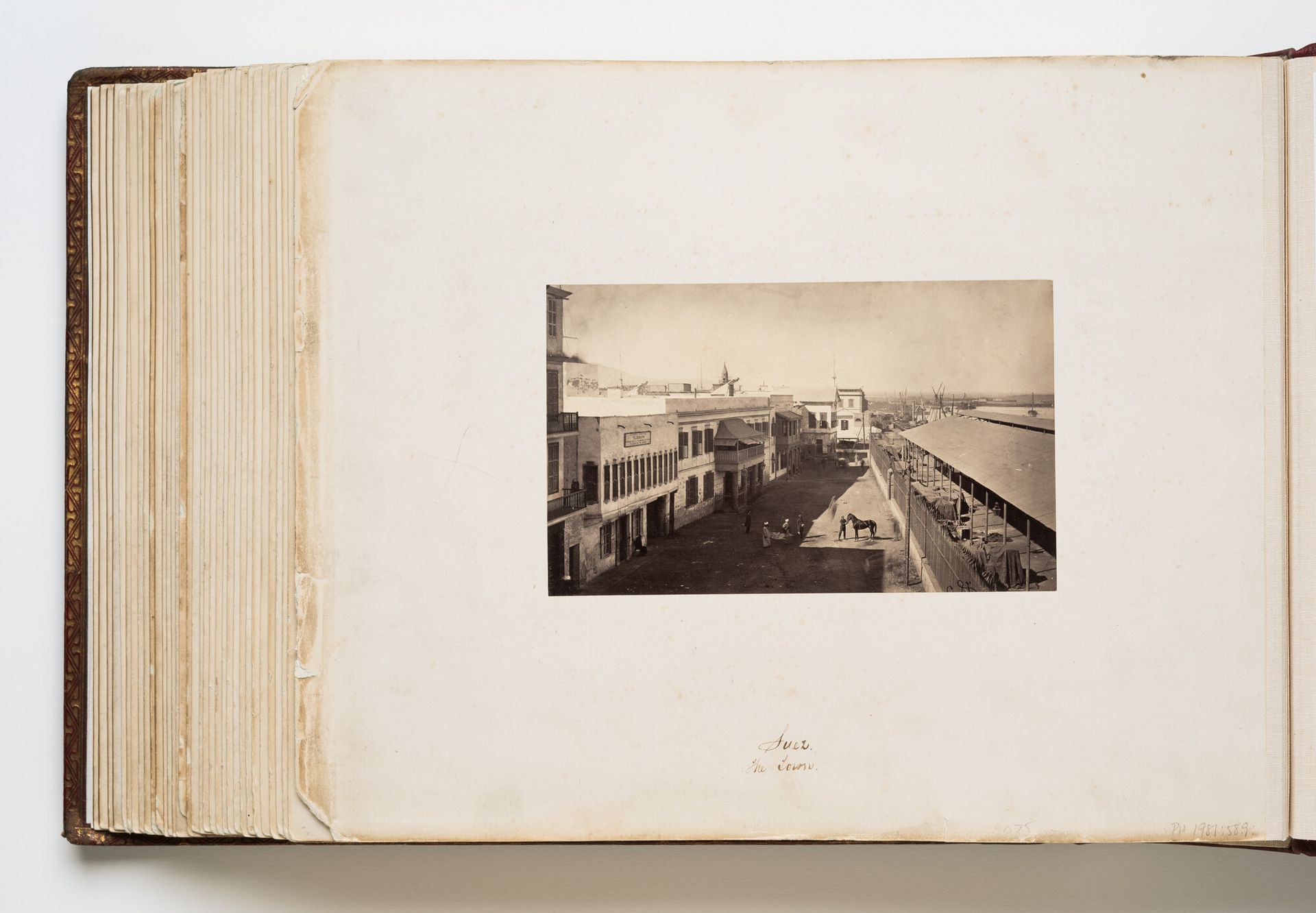
View of Suez Town, Suez Canal, Egypt, ca. 1869. PH1981:0589:075. Albumen print © CCA
Laid in 1861 by British steamships, the Malta & Alexandria Telegraph line ultimately reached Suez as part of the infrastructure connecting Bombay to London. This particular cable, a gutta percha line manufactured by Glass, Elliot & Company that linked Malta to Suez, was originally intended for Southeast Asia to link Rangoon with Singapore.1 Enter PH1981:0589 (again). With both Rangoon and Singapore—photographed by J. Jackson and A. Sachtler respectively—included in the album, this telegraph line tracked faithfully on the networks that made possible both the making of PH1981:0589 and its subsequent acquisition by the CCA on Friday 27 March 1981 from Sotheby’s London.2 That is to say, from its assembly to its itinerary, PH1981:0589 indexes the aqueous networks whose worldmaking connections were thoroughly rearticulated in the latter part of the nineteenth century—an infrastructural rearticulation heavily mediated by architectures of land and of sea, by buildings and ships. The album’s very presence at the CCA does more than weave together maritime and telegraph networks illustrating how they furnished the material conditions for dataland and how they restricted or channeled its development. It directs attention to the production of a data-sea, suggesting that architecture—the art tasked with creating habitable environments—is not merely shaped by the logics of spatial information management that define dataland but also exists as part of the larger technological apparatus that enables such logics.
Piergianna Mazzocca
While researching oil’s imbrications into the management of life in the CCA Collection, I discovered a book about the documentary photography project undertaken by Standard Oil of New Jersey from 1943 to 1950. The book’s title honors Roy Stryker, the project’s director. Stryker was an economics lecturer at Columbia University and previously served as the chief of the “historical section” at the United States Farm Security Administration (FSA) before World War II, where he directed the federal agency’s photographic documentation of the New Deal era. Given the FSA project’s success in communicating the rural conditions and poverty-ridden landscapes of the United States during that time to the public, Stryker was invited to join Standard Oil’s public relations department to oversee the company’s documentary project aimed at improving its public image. Following a series of Senate hearings conducted by the head of the Antitrust Division of the Department of Justice, which investigated the company for cartel arrangements with foreign businesses, officials from the oil company aimed to alter the perception of their most vocal critics—professionals, academics, and business leaders.1 Their goal was to cultivate a group of “opinion leaders” who could help sway public opinion in their favour.2 Consciously targeting a well-educated audience, one that could appreciate the artistic as well as the technical aspects of the industry, Standard Oil selectively chose the visual media needed to project a public image of the company as a “good citizen” operating with the public’s interest in mind—but it would finally be under Stryker’s guidance that the project found its direction.3
The project aimed to show the positive influence of the oil industry on American life, focusing on its employees, their communities, and society at large. Many photographers who had previously worked for the FSA—such as Arthur Rothstein, Gordon Parks, Russell Lee, John Vachon, and John Collier Jr—and several others were hired for the initiative, resulting in a massive collection of more than 67,000 photographs documenting various aspects of the oil industry and its landscapes, and providing a broader view of American life during the war and the early postwar years. But unlike the FSA photographs, which captured the socioeconomic hardships of the Depression era, the Standard Oil photographs “generally documented the thriving producers and consumers of oil.”4 As Edwin Rosskam, one of the project’s photographers, would describe them, the photographs were “more representative of the technological America that was being born in the 40s.”5 The photographs’ circulation speaks of their allure: these were disseminated freely in the pages of popular magazines such as Fortune, Time, Life, and Vogue, appeared as illustrations in school textbooks, and were exhibited in fine arts museums such as MoMA.
Based on this record, Standard Oil’s collection of documentary photographs—a selection of which is contained in the book and the accompanying exhibition of the same name, held at the International Center of Photography in New York in 1983 with support from the Exxon Corporation—can be seen as an attempt by the oil company to legitimize and normalize the environmental transformations occurring throughout the hemisphere in the postwar context. However, the large number of photographs in the collection also illustrates how the excesses of the oil industry, whether by its wealth or power, were transformed into cultural products. Through the lens of its photographers, knowledge and information about life in and out of extraction landscapes, rendered in black and white, showcased the extent to which oil leaked into daily life. As Elizabeth Barrios has recently pointed out: “[…] part of the mess left behind by the oil exuberance of twentieth-century societies is cultural: we have come not only to desire, but also to expect the ease of life made possible by oil.”6
The collection can also be read as constituting another way of knowing oil, for Stryker’s work, both in assigning photographers to document the industry and in collecting the resulting photographs, was that of the historical archivist. As a contemporaneous review of the exhibition in the New York Times characterized it, “[Stryker] thought of his undertakings as documentary and historical in nature, and in handing out assignments he favored photographers who would, as he put it, use the camera as a means of ‘communicating facts’.” 7 If the photographs, following their authors’ and Stryker’s claims, allegedly documented a particular reality tied to the oil industry in the 1940s United States, they also documented how the industry (in its propaganda campaign) and Stryker (in his archival activities) constituted themselves as historical actors. While processes of accumulation support the fossil fuel industry—from the biological matter needed for fossil fuel formation to extraction and the capital required for its commodification—the accumulation of images documenting its activities is essential to the writing of its history.
The comprehensive documentary photography projects that closely tracked the activities of large-scale oil companies, such as Standard Oil or Royal Dutch Shell, are not only critical archives to the writing of oil’s history but also common in places across the globe where the industry operated. These companies employed photographers to document their operations both abroad and offshore, making their visual records vital to tracing oil’s impact and legacy. Photo collections like this one (Stryker’s work at the FSA and Standard Oil is now archived at the University of Louisville library) exemplify how infrastructural and ideological support systems shape the production of knowledge about oil. But most importantly, they also demonstrate how knowledge is continuously created and recreated through the systems enabled by hydrocarbon capitalism. My initial encounter with the book in the CCA Collection refracts these entanglements.
For historians (especially architectural historians) of oil, accounting for the history of infrastructure is particularly relevant to our craft. As we sit at our desks writing these histories, it is worth noting how much of our work depends on the archives funded and inaugurated by the industry.
-
Steven W. Plattner, “Introduction,” in Roy Stryker: U.S.A., 1943-1950, (University of Texas Press, 1983), 12. ↩
-
Ibid., 13. ↩
-
Larson, Knowlton, and Popple, as cited in Steven W. Plattner, “Introduction,” in Roy Stryker: U.S.A., 1943-1950, (University of Texas Press, 1983), 18. ↩
-
Plattner, “Introduction,” 22. ↩
-
Edwin Rosskam, as cited in Steven W. Plattner, “Introduction,” in Roy Stryker: U.S.A., 1943-1950, (University of Texas Press, 1983), 23. ↩
-
See Elizabeth Barrios, Failures of the Imagination: Reckoning with Oil in Venezuelan Cultural Production, (University of Pittsburgh Press, 2026), forthcoming. ↩
-
Gene Thornton, “Photography View; A Rose Tinted View of America in The 1940’s,” New York Times, May 29, 1983, https://www.nytimes.com/1983/05/29/arts/photography-view-a-rose-tinted-view-of-america-in-the-1940s.html#:~:text=Entitled%20’‘Roy%20Stryker%3A%20U.S.A.,in%20newspapers%2C%20magazines%20and%20books. ↩
Giuditta Trani
Acoustic data visualization has historically functioned as a tool of territorial control. Initially developed within military contexts during World War I to manage and dominate space through technologies such as radio, radar, and sound mirrors, these practices were later incorporated into urban planning.1 In this context, acoustic maps and diagrams shaped zoning strategies and contributed to the uneven distribution of environmental privilege, separating areas exposed to industrial noise from legally protected, quieter residential zones. Beyond visual cartography, acoustic visualization sought to map invisible components—such as the sound environment—in order to extend the limits of visible knowledge.
This trajectory was consolidated in postwar Britain through the institutionalization of acoustic regulation. In 1960, the Noise Abatement Act was promulgated in the UK. Promoted by the Noise Abatement Society, the law brought together decades of inquiries into urban noise pollution, which had become a central concern in housing policy following the industrial revolution and the widespread introduction of loud machinery into the global production system. By the 1960s, earlier military logics of acoustic monitoring were translated into urban governance through zoning plans, diagrams, and surveys of the urban soundscape, as documented, for example, in the yearly urban design bulletins published by the City of London.
Within this broader system of control, DIY alternatives to surveillance-oriented uses of sound technologies emerged within the framework of Cedric Price’s Housing Research project, now held at the CCA as part of the Cedric Price fonds. Proposed in the context of the radical architectural debates of the late 1960s and early 1970s, and shortly after the promulgation of the UK Noise Abatement Act, the project responded critically to the institutionalization of sound as a regulatory parameter.
Housing Research proposed a creative “detournement” of acoustic measurement practices through the introduction of a “site sensing kit,” enabling dwellers to select building sites according to both visible and invisible environmental conditions. Redirecting tools originally developed for territorial control toward new forms of individual agency and environmental awareness, the project redistributed access to acoustic measurement and interpretation, reframing sound as an experiential and contested domain rather than a neutral substrate. In doing so, it anticipated some of the issues of “acoustic justice” later explored by sound studies in the following decades.2
-
For the genealogy of sound technologies, war and the city see: Thompson, Emily. The Soundscape of Modernity: Architectural Acoustics and the Culture of Listening in America, 1900–1933. Cambridge: MIT Press, 2004, 241; Goodman, Steve. Sonic Warfare: Affect and the Ecology of Fear. Cambridge: MIT Press, 2012, 31. ↩
-
Labelle, Brandon. Acoustic Justice: Listening, Performativity, and the Work of Reorientation, London: Bloomsbury, 2021, 114. ↩
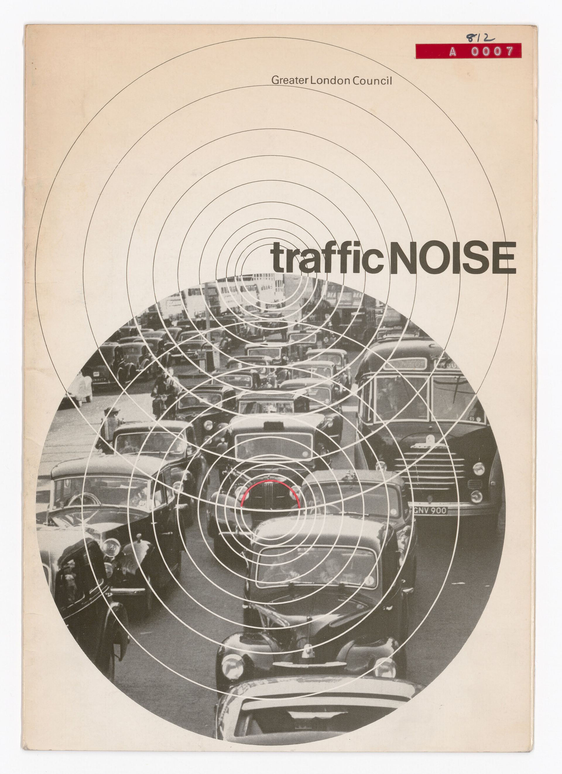
Cedric Price, Great London Council, Urban Design Bulletin, Traffic Noise, ca. 1967. DR2004:0260:002. Cedric Price Fonds, © CCA
The booklet of the project, proposed by Price to the City of London and published in Architectural Design in September 1971, details the operation of this “kit.” Central to it was the sound level meter—a recently patented portable device—reframed not as an instrument reserved for municipal authorities, but as a means through which inhabitants could develop awareness of sound pressure levels in their prospective living environments.1 The kit established a full-circle DIY process, spanning from preliminary site evaluation and environmental measurement to the physical construction of the dwelling, foregrounding the unseen dimensions of habitation.
Conceived as a playful device, the project reframed housing design as a non-specialist practice open to discussion at the grassroots level. Acoustic and visual data were introduced through game-like representations and participatory design processes, challenging the assumption that environmental data must be mediated exclusively through expert or institutional frameworks.
-
The sound level meter is an instrument used to measure the sound pressure levels (expressed in dB), monitoring the noise pollution conditions of an area. The Danish company Brüel & Kjær launched the first portable Sound Level Meter in 1962. ↩
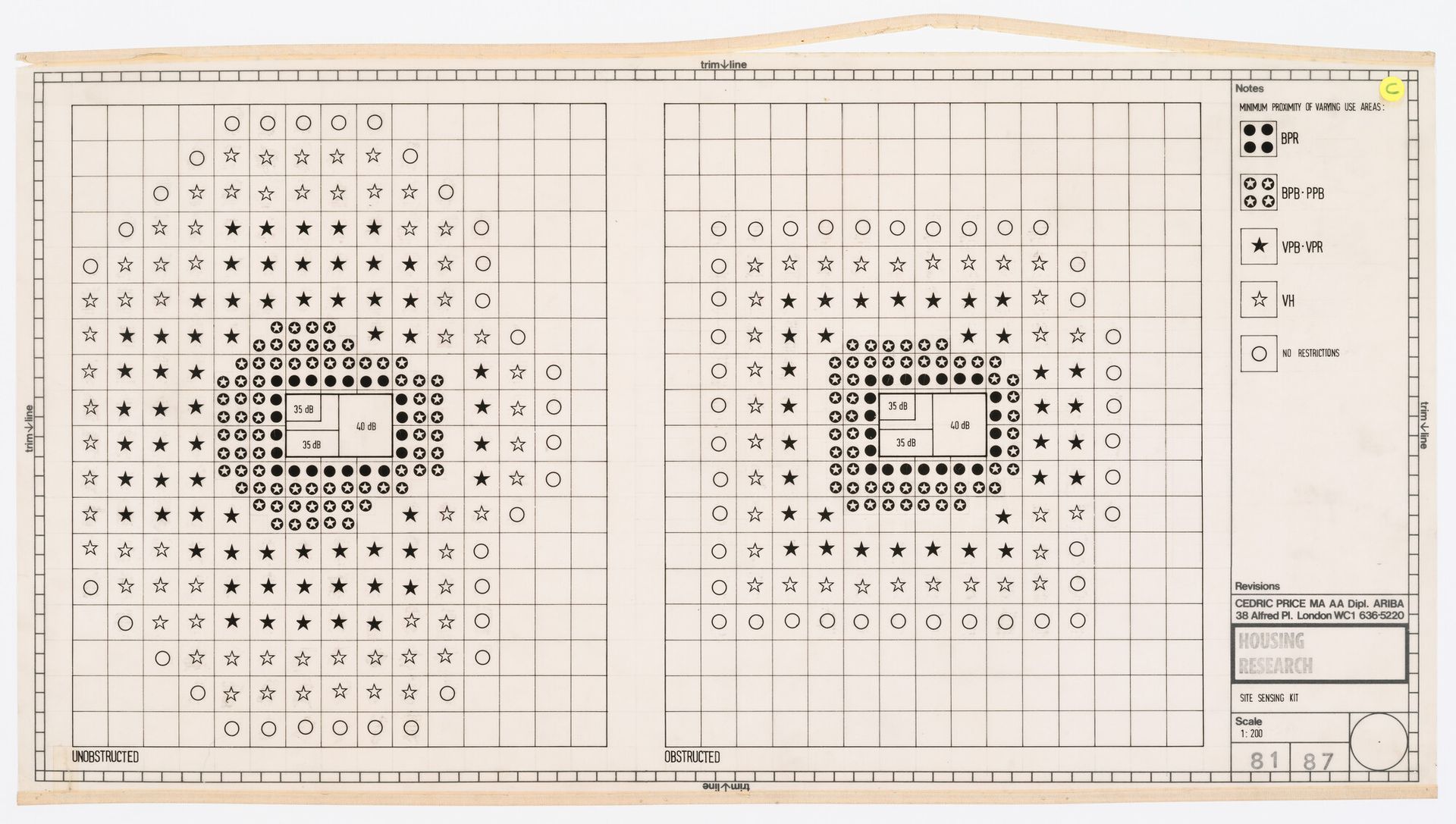
Cedric Price, “Conditioning grids” for “Site Sensing Kit”, from the project file “Housing Research”, ca. 1967. DR2004:0232:006. Cedric Price Fonds, © CCA
As the project explicitly stated, noise could not be reduced to quantitative thresholds alone, but depended on social and relational contexts: “A stranger’s car at midnight is a nuisance, your daughter’s car is a relief—both the same dBs.”1 In this way, Housing Research introduced a qualitative dimension into debates on sound regulation, anticipating what would later be described as a “new ecology of listening.”2 The acoustic dimension, alongside the visual and constructive ones, was framed as a practice that “must be capable of being played.”3
Katrin Zavgorodny-Freedman
Architectural work is (almost) always spatially distributed, as even the simplest and smallest teams are often split between an office and a worksite. As one of Canada’s most prolific post-war firms, Arthur Erickson Architects (AEA) formed a vast production network which stretched across the country, the continent, and the world: permanent offices in Vancouver, Toronto, and Los Angeles, with site and temporary offices in the Middle East, Europe, and other parts of North America. The Canadian Chancery project, located in Washington, DC, was designed by the AEA Toronto office under regular oversight from the Department of External Affairs in Ottawa. Despite the relatively-short distance between the three cities, the factors of checks and balances, international boundaries, and edges of languages spoken across designers, building disciplines, and government officials expressed in textual and visual form betray the limits to knowledge transmission across a great number of interested parties.
Buried within monthly construction progress reports are photographs of the site, possibly taken by an AEA remote team member based in DC, Doug Campbell. Found among other mundane documents, from daily manpower attestations to meeting minutes, weather logs, and consultant and laboratory reports, these images are covered in plastic set on black card stock pages. While some photographs are very plain (standard single images of one detail or another), others combine several photographs into glitchy “panoramas.” These latter images exist in uneasy contrast to the exhaustive data contained in the hefty spiral-bound report book. The written content falls somewhere between actionable information and simple posterity to respond to its mixed technical and government audiences, each of whom require elaborate mechanisms of copious knowledge and thorough recordkeeping to exercise control and perform oversight. With the plain photographs relaying a simple message of documentation at an incremental level, the photomontages divulge an altogether more complicated aim: visually communicating [AP4.1]the wholeness of the site to those who cannot “be” there. Because of the inability to capture and directly translate the scene in one shot, the landscape of the construction site is immortalized in composite form.
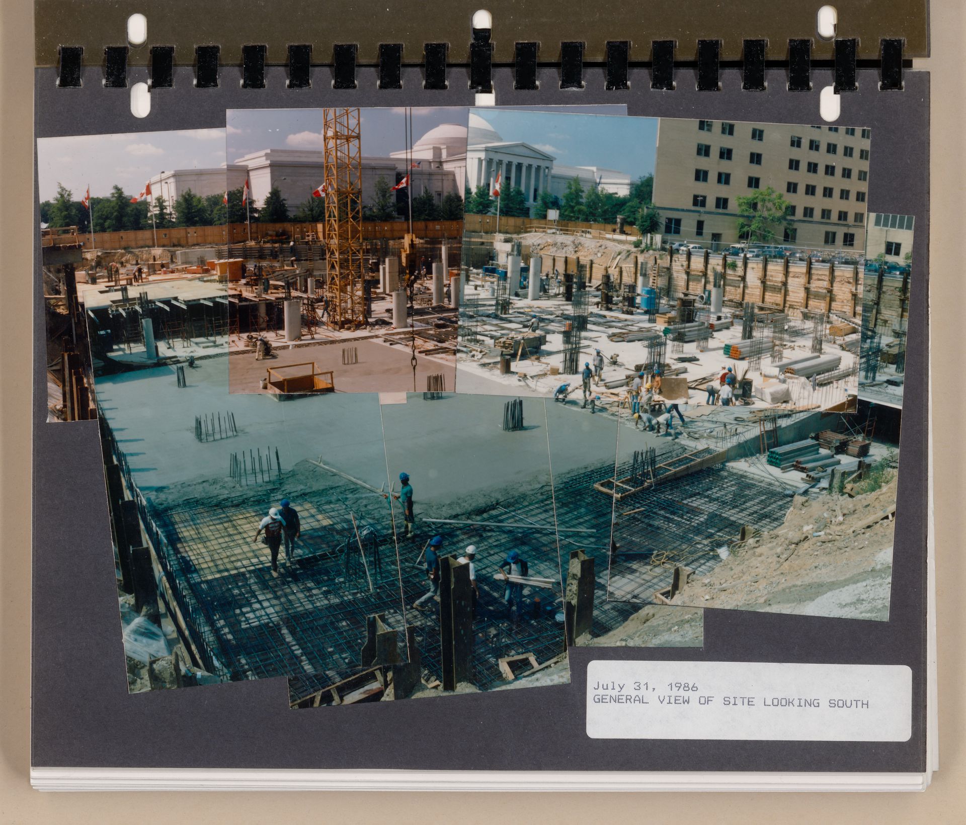
Photomontage of construction site at the new Canadian Chancery, DC. General View of Site Looking South, July 31, 1986. Found in Doug Campbell, Monthly Progress Report No. 4, July 31, 1986. ARCH255067. Arthur Erickson Fonds, Gift of Arthur Erickson, © CCA
General View of Site Looking South captures the early progress of construction as of 31 July 1986 in a set of seven photographs laid over one another. The subject of the image, the in-progress work, is held in greater esteem than the existing built environment in the background, where the dome and portico of the National Gallery are spliced and in duplicate, while the Chancery’s framing and poured concrete below are carefully lined up to visually make sense. Roughly thirty workers are frozen in time––many fully within the framing of a single photograph, others’ legs disproportionately lined up at the edges of two. Still a further few are abruptly cut off, “losing” their torsos or legs (a haunting parallel to the visceral dangers of a construction site) at the boundaries of one photo or another. The collage’s figures are spectres, some possibly traversing the site before being captured more than once across the composition. Almost four dozen more are not seen here at all—daily manpower logs for that sunny Thursday noted one operator, thirty carpenters, twenty-five labourers, seven cement masons, three field engineers, and nine subcontractors.[1] These and other flickers—including the mix of horizontal and portrait orientation of the photos, their differing sizes, and the varying lighting conditions of cool and warm tones—signal an oscillation between the viewer’s immersive belief of the composite as a faithful reproduction of the site and the sheer impossibility of such a feat. An unrealistic multiplication, these seven photographs must spread out over the 8.5x11” page to relay their “wholeness,” exemplifying the limit of knowledge transmission: a hacking, working around, and stepping over not unlike the presence of a worker on site.
-
Doug Campbell, Monthly Progress Report No. 4, July 31, 1986, n.p., file ARCH255067, box 22-TOR-728T, Arthur Erickson Fonds, CCA. ↩
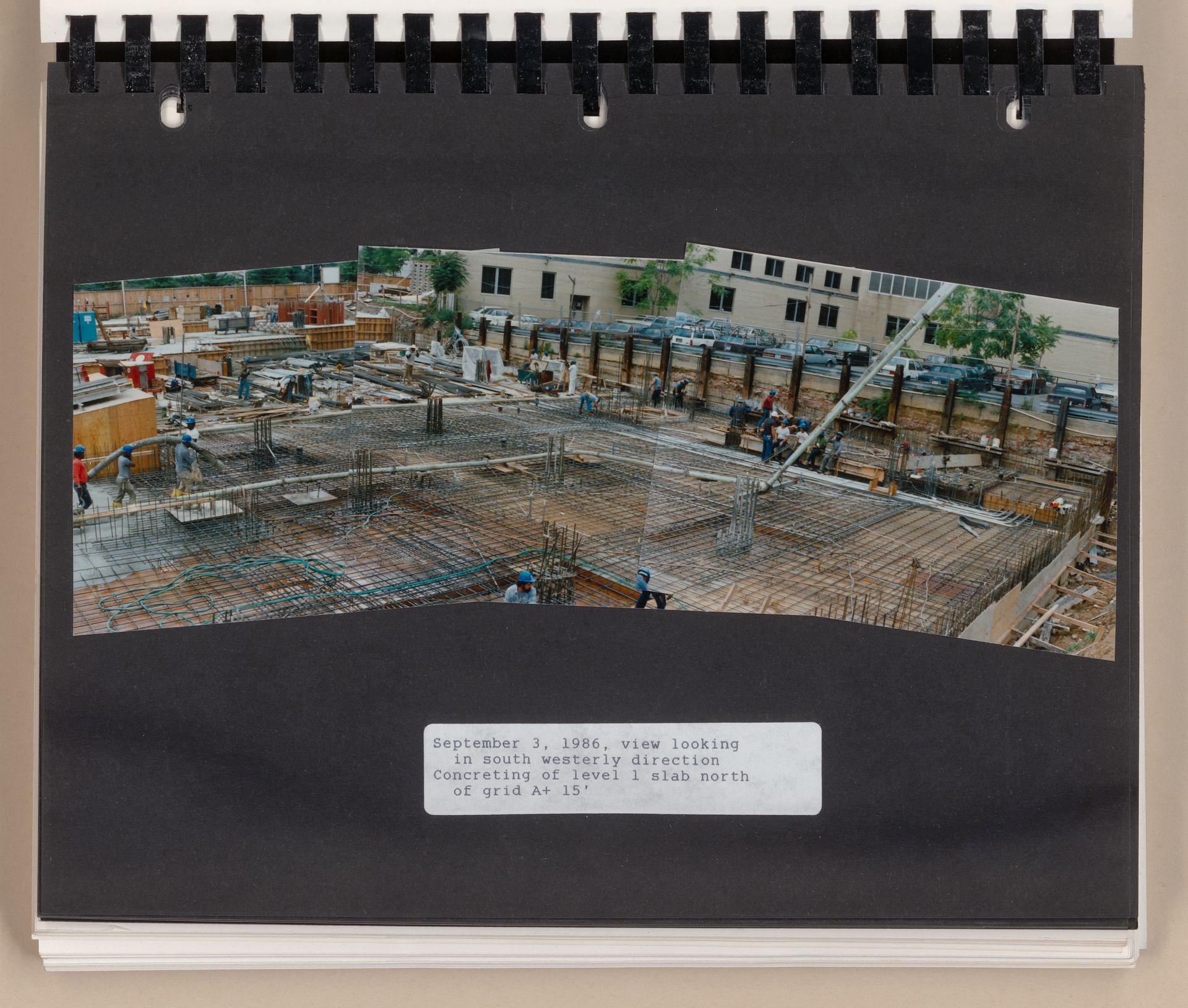
Photomontage of construction site indicating a southwest view of a level of concreting in progress. Found in Doug Campbell, Monthly Progress Report No. 6, September 3, 1986. ARCH255067. Arthur Erickson Fonds, Gift of Arthur Erickson, © CCA
Existing alongside each other in the report, the attempts of the visual and textual media to make the physical processes of work legible exposes the limits to understanding progress at a remote location. An epilogue, by way of conclusion: additional copies of each monthly report found among AEA boxes remind us that reproductive technology like the photocopier render all the collected documents as image, no matter their origin. During the act of “copying”, text and visuals are “photographed”, subjected equally in the eyes of the Xerox machine with which they are observed. Spat out on the other end, our photomontage pages yet once more declare the limitations of communication media in relaying signals: now in black and white, flat, and with severely reduced detail, these images slip further into a world where physical presence and human eyesight cannot be replicated on paper.


