Tripoli: Who Took Away Our Land? (Part 1)
Public Works Studio presents the social and environmental repercussions of the city’s public management
This article is based on a research project launched by Public Works Studio in June 2022 to examine Tripoli’s urban issues and consider them in an historical and social context. The project included a series of research workshops, held in October 2021, called “A Participatory Research Space to Activate the Right to the City and Housing in Tripoli,”1 in which a selected group of the city’s residents were invited to participate. The article addresses the city’s most significant problems: the planning tools, such as the land consolidation and subdivision projects; degradation of the built environment in the historic districts following their heritage classification; and the deterioration of public housing projects in Tripoli due to poor management.
-
During the workshops, the housing problem was addressed mainly in four of the city’s districts: Al-Tal/Zahriyeh, Al-Masaken Al-Shaabya, Al-Hara Al-Jadida (including Hay Al-Tanak), and Hay Dahr Al-Moghr (including the Taht Al-Sibat neighbourhood), with emphasis placed on how the historical context shaped the residents’ relationship with their neighbourhood and the ways in which they apprehend their urban environment and the evictions when they take place. The participants analyzed all the data and stories gathered during their fieldwork and ultimately transformed them into tools for advocacy and organization around a number of problems that emerged in the city. ↩
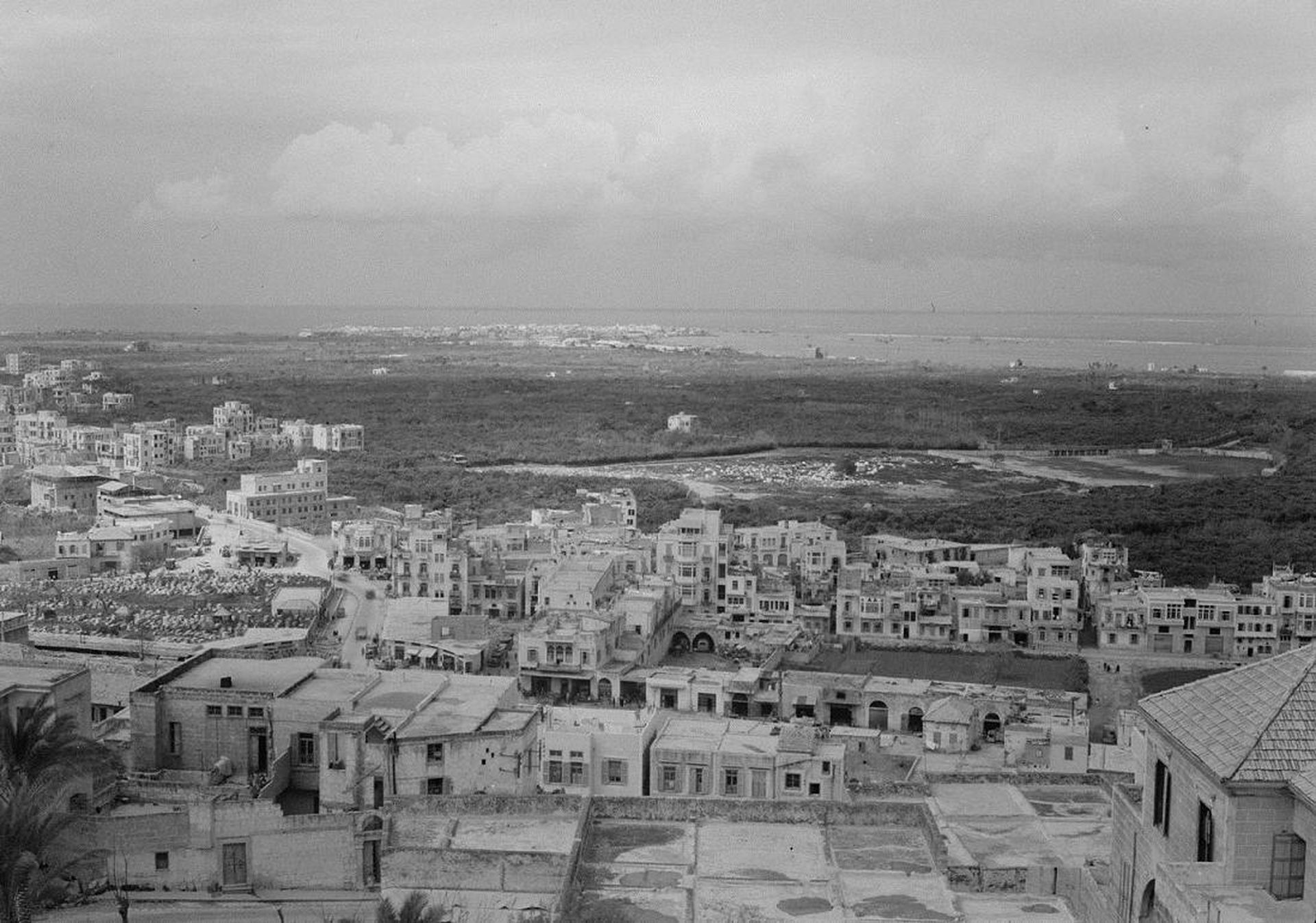
Unknown photographer, Tripoli, Lebanon – view of Al Mina and sea, 1946, Exhibition print © Liszt Collection
Tripoli “Al-Fayhaa” is the second capital of Lebanon, the capital of the country’s north. Such a designation might imply that Tripoli is an economic and development hub for the country’s entire northern region, as evidenced by the approach taken during visits by the IRFED mission1 and the Lebanese National Physical Master Plan.2 However, the reality is quite different. Today, Tripoli is the poorest city on the Mediterranean coast and its residents suffer from deprivation, deliberate neglect, and difficult housing conditions in marginalized neighbourhoods. Although numerous plans and projects have been implemented with a view to modernizing the city, in fact they are largely responsible for the issues facing the city today. None of the strategies developed have established an inclusive vision of housing in marginalized residential neighbourhoods or addressed these districts as an organic part of the city; rather, these neighbourhoods have been regarded as undesirable outgrowths.
-
The IRFED (Institut international de recherche et de formation, éducation et développement) mission was an in-depth investigation of economic and social conditions in Lebanon, conducted in the 1960s following an invitation by Lebanese president Fouad Chehab to the economist and developmentalist Père Louis-Joseph Lebret, founder and president of IRFED. The mission resulted in a development program, the first of its type in Lebanon, that was never implemented. ↩
-
The sector-based Plan général d’aménagement du territoire libanais was approved in 2009. The plan constitutes the main pillar of the urban development policy and the unified geographic reference for land occupation in Lebanon. ↩
The Residents Facing Land Consolidation and Subdivision Projects
“General consolidation and subdivision” is an urban planning and design tool used by public authorities to reshape land in a specific zone – through a legal and engineering process – in order to convert it into buildable property.1 This tool, as used in many regions of Lebanon, has often led to the destruction of agricultural areas without offering a solution for appropriate urban and residential expansion.
In Tripoli, the consolidation projects subscribed to a capitalist vision of the city based on the need to “clear out” its poor population and get rid of its agricultural economy; the goal was to create a renewed city based on seafront tourism, services, an international fair,2 and an economy based on income from property. In the early twentieth century, Tripoli was full of lemon groves; now they are a distant memory.
It seemed obvious, starting with the first city plan formulated in 1947,3 that the question of urban expansion would revolve around real estate development. In the 1950s and 1960s, urban sprawl overran agricultural zones, and a gradual drop in investments in farming and industry led to a shift of economic activity toward the construction sector and real estate promotion. Therefore, as a result of political decisions directed by master plans that increased investment and successive consolidation projects, the construction sector replaced the basic productive sectors.
-
For more information, see Public Works Magazine, “Residents Facing Land Consolidation and Parcellation Projects: The Example of El-Tanak Neighborhood in Mina,” 11 February 2022, https://publicworksstudio.com/en/residents-facing-land-consolidation-and-parcellation-projects/. ↩
-
Rashid Karami asked the General Directorate of Urban Planning to draw up a preliminary design for the “Al-Fayhaa” project. The project was entrusted to the architects Henri Eddy (Scaffolding of Engineers and Architects in Beirut) and Georges Doumani (Scaffolding of Engineers and Architects of Tripoli). The preliminary study was completed in 1964 and the detailed study was not carried out. ↩
-
The Swiss architect Ernst Egli’s master plan. ↩
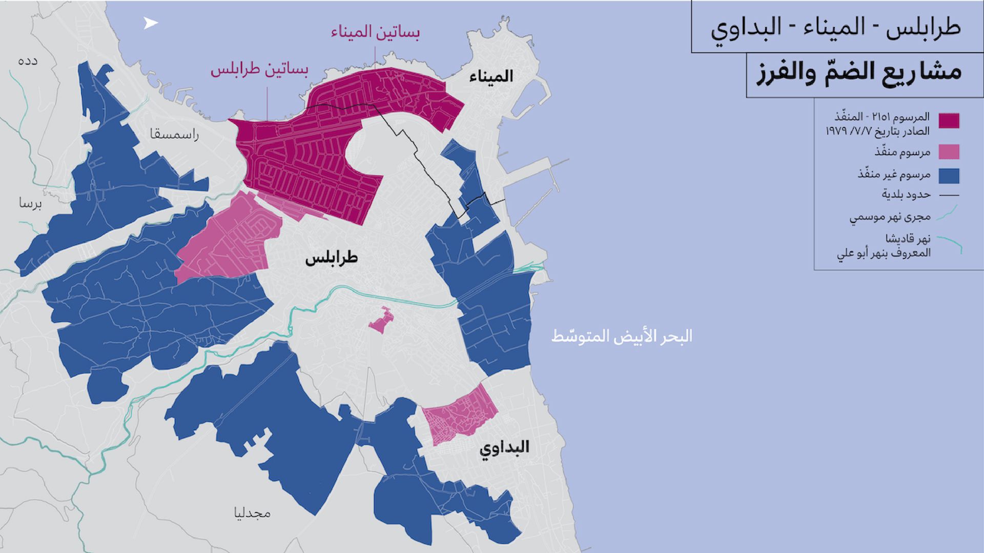
Map of Land Consolidation and Subdivision projects in Tripoli. In dark pink, implemented consolidation and subdivision by decree 3151 / 1979; in light pink, implemented consolidation and subdivision by other decrees; in blue, planned but unimplemented. © Public Works Studio
Among the consolidation projects was decree 2151, promulgated in 1979, which affected the Basateen areas in Tripoli and Al-Mina. The project’s analysis did not include prior research on real housing needs. Administrative delays, the civil war,1 and conflicts around investment rates considerably slowed the decree’s progress, however, and it was not ratified until 2003.
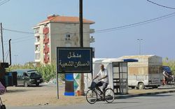
After 2004, construction activity in the Basateen areas increased following the municipal council’s decision to cancel the construction freeze imposed on the zone. The need to supply new housing was not the main reason for this decision; in fact, it produced an imaginary housing demand: more than 55 percent of dwellings in the consolidation zone were still vacant in 2012. The projects were built without consideration of part of the residential community characterized by informal housing near the west side of Basateen Al-Mina, known as “the new neighbourhood” and “Hay al-Tanak.”
-
The multipronged Lebanese civil war lasted from 1975 to 1990. ↩
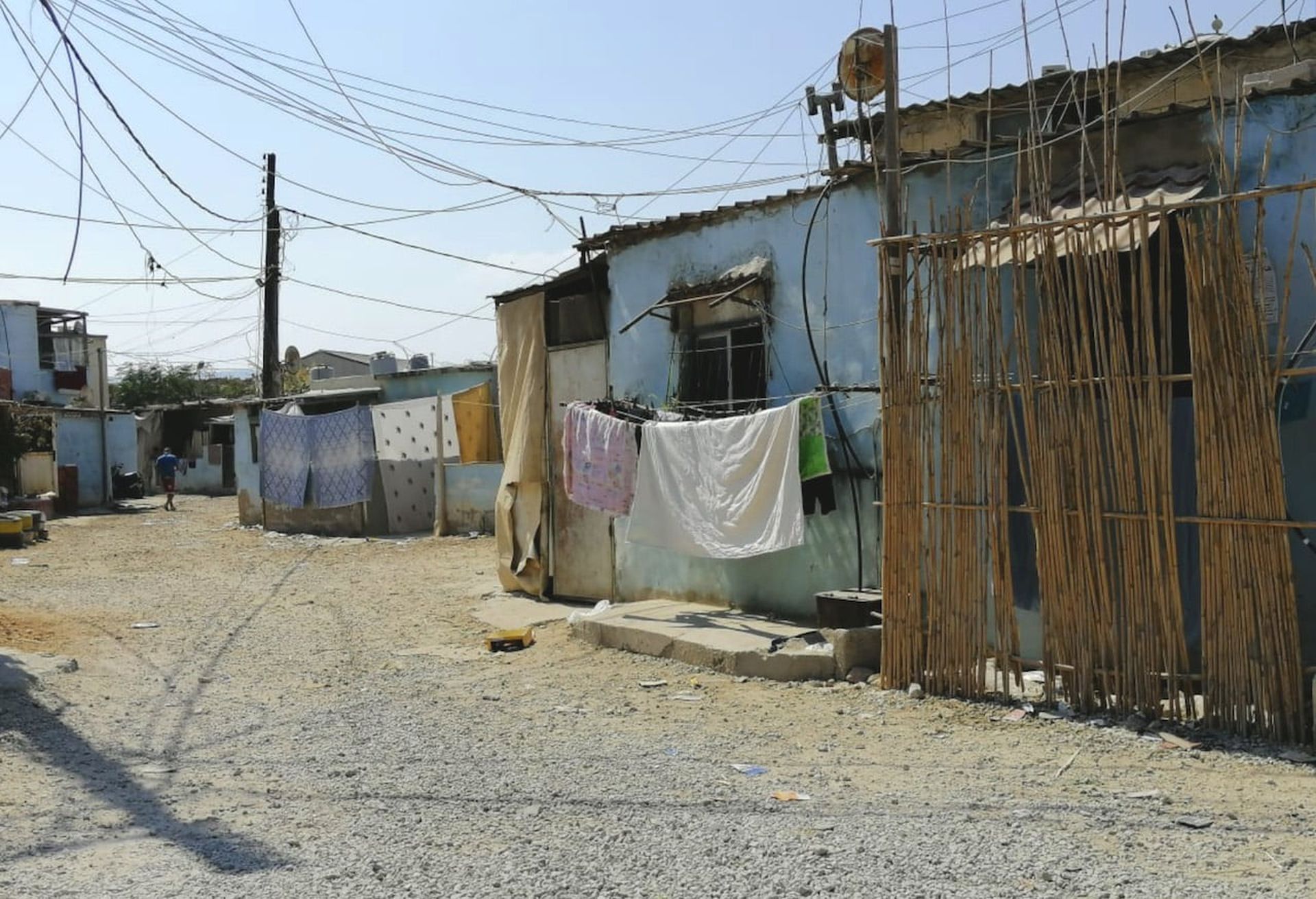
Hay Al-Tanak informal neighbourhood © Public Works Studio
The new neighbourhood, is the oldest informal district in Tripoli and Al-Mina, but it does not appear on official maps. Since 1970, it has become a small town into which various industries have spread, as a natural extension of the port’s activities. Part of Hay Al-Tanak is in the new neighbourhood, and it extends from that area toward the sea. It came into existence at the beginning of the civil war and saw strong growth in the mid-1990s. Those who settled there, fleeing the fighting or unable to afford the rent in other parts of the city, built houses with sheet-metal roofs. Today, about 1,300 families live there.1
When the general consolidation plan was formulated, the General Directorate of Urban Planning ignored the reality in the field and was content to orient development of the area and redistribution by scribbling on paper in the consultants’ offices. It has been proved that a large part of Hay Al-Tanak and the new neighbourhood stood on municipal land allotted for construction of a public park, which created a conflict between the city and the residents, and some owners were surprised to find that the parcels they had purchased were already occupied. The goal of this project was “to organize the zone in order to reduce its random nature and eliminate communitarianism and violations,” but it was not implemented because it was impossible to evict the inhabitants.
In conclusion, the state imposed general consolidation and subdivision projects and ignored the existence of the new neighbourhood and Hay Al-Tanak. It also set the land owners against the inhabitants of both neighbourhoods, who were abandoned to their fate without alternative housing solutions. Furthermore, the municipality used the excuse that the residents were squatters to undermine the provision of basic services and infrastructure: they were therefore forced to live in degraded housing and health conditions and were not allowed to bring in the construction materials needed to rehabilitate and maintain their dwellings, on the pretext of the informal status of the neighbourhood. The state also opened this zone to real estate speculation instead of preserving its social value. Even as the political authority was constantly trying to obliterate the informal neighbourhoods in order to replace them with “upscale” housing that would generate rental income for it and its money-hungry allies, it exploited the residents through electoral rhetoric, sprinkled with hollow promises guaranteeing alternative housing.
-
The neighbourhood’s inhabitants are a mixture of residents of Al-Mina, Akkar, Al-Danniyeh, as well as Palestinians who moved there after the fighting in Nahr Al-Bared in 2007 and Syrian refugees who moved there in 2011 when large numbers of Syrians were displaced. ↩
Related exhibition
Related articles

References
• Chahine, Maryline. May 2021. “How Uneven Aid Distribution Creates Divisions in Hay Al-Tanak,” Beirut Today. https://beirut-today.com/2021/05/03/how-uneven-aid-distribution-creates-divisions-in-hay-al-tanak/.
• Dewailly, Bruno. 2015. Pouvoir et production urbaine à Tripoli Al-Fayha’a (Liban): quand l’illusion de la rente foncière et immobilière se mue en imperium. Rabelais de Tours: ÉCOLE DOCTORALE “Sciences de l’Homme et de la Société” UMR 7324 CITERES – Équipe Monde Arabe et Méditerranée (EMAM), Université François, France.
• Ginzarly, Manal. 2014. “An Ecological Approach to Riverfronts Revitalization: The Case of Abu Ali River Corridor in Tripoli.” Master’s thesis, American University of Beirut. https://scholarworks.aub.edu.lb/handle/10938/10087.
• Kabbara, Abdullah. 1970. Al-Mina: la ville de la mer raconte son histoire. Tripoli.
• Kabbara, Nazih. 2012. Tripoli au XXe siècle. Université Al-Manar de Tripoli.
• Lahoud, Adrian. 2013. “Architecture, the City and Its Scale: Oscar Niemeyer in Tripoli, Lebanon,” The Journal of Architecture 18 (6): 809–34. https://discovery.ucl.ac.uk/id/eprint/1388142/1/10.1080-13602365.2013.856931.pdf.
• Monjed, Talal. 1988. “Mojtamaa al Nahr.” Institut des sciences sociales – Branche 3 de l’Université libanaise, Tripoli.
• Public Works Studio. 2021. “A Participatory Research Space to Activate the Right to the City and Housing in Tripoli,” series of research workshops.
• Public Works Studio. February 2022. “Residents Facing Land Consolidation and Parcellation Projects: The Example of El-Tanak Neighborhood in Mina.” Public Works Magazine, https://publicworksstudio.com/en/residents-facing-land-consolidation-and-parcellation-projects/.
• Public Works Studio. April 2022. “Tripoli, a ‘Heritage City’ at the Expense of Its Residents.” Public Works Magazine, https://publicworksstudio.com/en/tripoli-a-heritage-city-at-the-expense-of-its-residents/.
• Public Works Studio. April 2022. “Tripoli: The Nakba of Unfinished Housing Projects.” Public Works Magazine, https://publicworksstudio.com/en/tripoli-the-nakba-of-unfinished-housing-projects/.
• Rajab, Mosbah. 2009. Les Grands Projets de Tripoli: Système de décision et besoins de réappropriation. Conquérir et Reconquérir la Ville (L’aménagement urbain comme positionnement des pouvoirs et contre-pouvoirs). ALBA, Lebanon.
• Samaha, Michel. 2015. “Public Authorities in Lebanon and the Challenges of Urban Informal Settlements: The Case of Tripoli.” Assadissa, journal of the Institut des finances Basil Fuleihan (in Arabic). http://www.institutdesfinances.gov.lb/publication/الإدارة-المالية-مدخلاً-لتحسين-أداء-ال/السلطات-العامة-وتحديات-العشوائيات-ال/.