


5845 Results
Form:
events
events
Date:
12 July 2012
12 July 2012
Form:
events
events
Date:
12 July 2012
12 July 2012
Form:
exhibitions
exhibitions
Description:
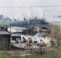
New towns created by private enterprise in the early years of the twentieth century bear witness to the confluence of economic, social, and political forces at work in shaping urban forms. Built quickly and expensively, these towns thoroughly planned to sustain industrial profits, relying on social control to ensure the hegemony of the ruling class. This exhibition traces(...)
New towns created by private enterprise in the early years of the twentieth century bear witness to the confluence of economic, social, and political forces at work in shaping urban forms. Built quickly and expensively, these towns thoroughly planned to sustain industrial profits, relying on social control to ensure the hegemony of the ruling class. This exhibition traces(...)
Location:
Main galleries
Main galleries
Date:
6 March 1996 to 26 May 1996
6 March 1996 to 26 May 1996
Title:
Power and Planning: Industrial Towns in Québec, 1890-1950
Actions:
Description:
New towns created by private enterprise in the early years of the twentieth century bear witness to the confluence of economic, social, and political forces at work in shaping urban forms. Built quickly and expensively, these towns thoroughly planned to sustain industrial profits, relying on social control to ensure the hegemony of the ruling class. This exhibition traces(...)
Power and Planning: Industrial Towns in Québec, 1890-1950
Actions:
Description:
New towns created by private enterprise in the early years of the twentieth century bear witness to the confluence of economic, social, and political forces at work in shaping urban forms. Built quickly and expensively, these towns thoroughly planned to sustain industrial profits, relying on social control to ensure the hegemony of the ruling class. This exhibition traces(...)
Form:
exhibitions
exhibitions
Date:
6 March 1996 to
26 May 1996
6 March 1996 to
26 May 1996
Location:
Main galleries
Main galleries
Form:
drawings, textual records
Quantity:
20 dessin(s)
drawings, textual records
Quantity:
20 dessin(s)
Actions:
Reference number:
ARCH168879
ARCH168879
People:
Form:
drawings, textual records
Quantity:
20 dessin(s)
drawings, textual records
Quantity:
20 dessin(s)
People:
Form:
exhibitions
exhibitions

Location:
Main Galleries Keyword(s):
Álvaro Siza, Siza, Giovanna Borasi, adamo-faiden, city, neighbourhood
Main Galleries Keyword(s):
Álvaro Siza, Siza, Giovanna Borasi, adamo-faiden, city, neighbourhood
Date:
21 May 2026 to 10 January 2027
21 May 2026 to 10 January 2027
Form:
exhibitions
exhibitions
Date:
21 May 2026 to
10 January 2027
21 May 2026 to
10 January 2027
Location:
Main Galleries Keyword(s):
Álvaro Siza, Siza, Giovanna Borasi, adamo-faiden, city, neighbourhood
Main Galleries Keyword(s):
Álvaro Siza, Siza, Giovanna Borasi, adamo-faiden, city, neighbourhood
Form:
events
events
Location:
Main Galleries and Shaughnessy House Keyword(s):
Álvaro Siza, Siza, Giovanna Borasi, The fortune of the city, adamo-faiden
Main Galleries and Shaughnessy House Keyword(s):
Álvaro Siza, Siza, Giovanna Borasi, The fortune of the city, adamo-faiden
Date:
21 May 2026, 5pm to 9pm
21 May 2026, 5pm to 9pm
Form:
events
events
Date:
21 May 2026
5pm to 9pm
21 May 2026
5pm to 9pm
Location:
Main Galleries and Shaughnessy House Keyword(s):
Álvaro Siza, Siza, Giovanna Borasi, The fortune of the city, adamo-faiden
Main Galleries and Shaughnessy House Keyword(s):
Álvaro Siza, Siza, Giovanna Borasi, The fortune of the city, adamo-faiden
Form:
events
events
Location:
Shaughnessy House
Shaughnessy House
Date:
4 March 2020, 1pm to 4pm
4 March 2020, 1pm to 4pm
Form:
events
events
Date:
4 March 2020
1pm to 4pm
4 March 2020
1pm to 4pm
Location:
Shaughnessy House
Shaughnessy House
Form:
articles
articles
Title:
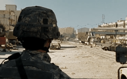
Occluding Baghdad
Occluding Baghdad
Actions:
Amin Alsaden on the violence inflicted by depictions of the city in Western films
Issue:
Figuring Territory
Figuring Territory
Published:
28 November 2022
28 November 2022
Title:
Occluding Baghdad
Amin Alsaden on the violence inflicted by depictions of the city in Western films
Actions:
Occluding Baghdad
Amin Alsaden on the violence inflicted by depictions of the city in Western films
Actions:
Issue:
Figuring Territory
Figuring Territory
Form:
photographs
photographs
Actions:
Reference number:
PH1984:0184:001-050
PH1984:0184:001-050
People:
Date:
published 1878
published 1878
Title:
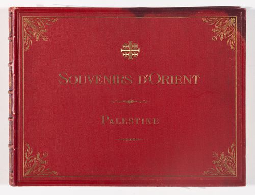
Souvenirs d'Orient. Album Pittoresque des Sites, Villes & Ruines les plus remarquables de la Terre-Sainte
Actions:
PH1984:0184:001-050
Souvenirs d'Orient. Album Pittoresque des Sites, Villes & Ruines les plus remarquables de la Terre-Sainte
Actions:
PH1984:0184:001-050
Form:
photographs
photographs
Date:
published 1878
published 1878
People:
Form:
drawings, works of art
drawings, works of art
Title:
Album of drawings and prints for a Hôtel de préfecture and a Hôtel de ville, Poitiers, France
Album of drawings and prints for a Hôtel de préfecture and a Hôtel de ville, Poitiers, France
Actions:
Reference number:
DR1974:0002:020:001-050
Description:
- This album contains drawings by Charles Rohault de Fleury which range from preliminary sketches to finished drawings - mostly plans, elevations and sections - for unexecuted projects for a Hôtel de préfecture and a Hôtel de ville for the city of Poitiers (Département de Vienne). Highly finished conceptual drawings dated September 1859 depict the general appearance and layout of the Hôtel de préfecture, however, the plans pertain primarily to the Hôtel du Préfet (DR1974:0002:020:003 - DR1974:0002:020:011). Transfer lithographs of working drawings for the Hôtel de préfecture dated November 1859 have detailed measurements showing the layout and construction of all the major building components (DR1974:0002:020:014 - DR1974:0002:020:018 and DR1974:0002:020:020). Also included are a plan and elevation dated February 1860 (DR1974:0002:020:013 and DR1974:0002:020:019). A site plan and perspective view for this Louis XIIIth style hôtel de préfecture have detailed keys (DR1974:0002:020:001 and DR1974:0002:020:002). The utilitarian structures for the Hôtel de préfecture, such as the portico pavilions and the Archives building, are constructed in a sparser style than the Hôtel du Préfet. The project for the Hôtel de ville is much less developed than that for the Hôtel de préfecture. Most of the drawings are unbound at the end of the album (DR1974:0002:020:035 - DR1974:0002:020:050). The two designs for this project, dated October 1859 and December 1859, are similar and depict an Italianate (Francis I ?) two-storey arcuated façade with pedimented windows, and coupled Corinthian columns. The construction materials are brick and stone. The two designs differ in the disposition of their flanking pavilions: the earlier project is housed under one roof (DR1974:0002:020:037), while the later project shows separate roofs for the pavilions (DR1974:0002:020:040 and DR1974:0002:020:042). Site plan DR1974:0002:020:012 indicates the proposed locations of the Hôtel de préfecture and Hôtel de ville: the former is situated near the train station between rue des Carmelites and boulevard Solferino, and the latter on a newly created square just west of the Hôtel de préfecture between rue des Grandes Écoles and rue de la Mairie.
DR1974:0002:020:001-050
Description:
- This album contains drawings by Charles Rohault de Fleury which range from preliminary sketches to finished drawings - mostly plans, elevations and sections - for unexecuted projects for a Hôtel de préfecture and a Hôtel de ville for the city of Poitiers (Département de Vienne). Highly finished conceptual drawings dated September 1859 depict the general appearance and layout of the Hôtel de préfecture, however, the plans pertain primarily to the Hôtel du Préfet (DR1974:0002:020:003 - DR1974:0002:020:011). Transfer lithographs of working drawings for the Hôtel de préfecture dated November 1859 have detailed measurements showing the layout and construction of all the major building components (DR1974:0002:020:014 - DR1974:0002:020:018 and DR1974:0002:020:020). Also included are a plan and elevation dated February 1860 (DR1974:0002:020:013 and DR1974:0002:020:019). A site plan and perspective view for this Louis XIIIth style hôtel de préfecture have detailed keys (DR1974:0002:020:001 and DR1974:0002:020:002). The utilitarian structures for the Hôtel de préfecture, such as the portico pavilions and the Archives building, are constructed in a sparser style than the Hôtel du Préfet. The project for the Hôtel de ville is much less developed than that for the Hôtel de préfecture. Most of the drawings are unbound at the end of the album (DR1974:0002:020:035 - DR1974:0002:020:050). The two designs for this project, dated October 1859 and December 1859, are similar and depict an Italianate (Francis I ?) two-storey arcuated façade with pedimented windows, and coupled Corinthian columns. The construction materials are brick and stone. The two designs differ in the disposition of their flanking pavilions: the earlier project is housed under one roof (DR1974:0002:020:037), while the later project shows separate roofs for the pavilions (DR1974:0002:020:040 and DR1974:0002:020:042). Site plan DR1974:0002:020:012 indicates the proposed locations of the Hôtel de préfecture and Hôtel de ville: the former is situated near the train station between rue des Carmelites and boulevard Solferino, and the latter on a newly created square just west of the Hôtel de préfecture between rue des Grandes Écoles and rue de la Mairie.
People:
Subject:
architecture, interior design
architecture, interior design
Date:
1859-1860, printed 1859-1860
1859-1860, printed 1859-1860
Title:
Album of drawings and prints for a Hôtel de préfecture and a Hôtel de ville, Poitiers, France
Actions:
DR1974:0002:020:001-050
Description:
- This album contains drawings by Charles Rohault de Fleury which range from preliminary sketches to finished drawings - mostly plans, elevations and sections - for unexecuted projects for a Hôtel de préfecture and a Hôtel de ville for the city of Poitiers (Département de Vienne). Highly finished conceptual drawings dated September 1859 depict the general appearance and layout of the Hôtel de préfecture, however, the plans pertain primarily to the Hôtel du Préfet (DR1974:0002:020:003 - DR1974:0002:020:011). Transfer lithographs of working drawings for the Hôtel de préfecture dated November 1859 have detailed measurements showing the layout and construction of all the major building components (DR1974:0002:020:014 - DR1974:0002:020:018 and DR1974:0002:020:020). Also included are a plan and elevation dated February 1860 (DR1974:0002:020:013 and DR1974:0002:020:019). A site plan and perspective view for this Louis XIIIth style hôtel de préfecture have detailed keys (DR1974:0002:020:001 and DR1974:0002:020:002). The utilitarian structures for the Hôtel de préfecture, such as the portico pavilions and the Archives building, are constructed in a sparser style than the Hôtel du Préfet. The project for the Hôtel de ville is much less developed than that for the Hôtel de préfecture. Most of the drawings are unbound at the end of the album (DR1974:0002:020:035 - DR1974:0002:020:050). The two designs for this project, dated October 1859 and December 1859, are similar and depict an Italianate (Francis I ?) two-storey arcuated façade with pedimented windows, and coupled Corinthian columns. The construction materials are brick and stone. The two designs differ in the disposition of their flanking pavilions: the earlier project is housed under one roof (DR1974:0002:020:037), while the later project shows separate roofs for the pavilions (DR1974:0002:020:040 and DR1974:0002:020:042). Site plan DR1974:0002:020:012 indicates the proposed locations of the Hôtel de préfecture and Hôtel de ville: the former is situated near the train station between rue des Carmelites and boulevard Solferino, and the latter on a newly created square just west of the Hôtel de préfecture between rue des Grandes Écoles and rue de la Mairie.
Album of drawings and prints for a Hôtel de préfecture and a Hôtel de ville, Poitiers, France
Actions:
DR1974:0002:020:001-050
Description:
- This album contains drawings by Charles Rohault de Fleury which range from preliminary sketches to finished drawings - mostly plans, elevations and sections - for unexecuted projects for a Hôtel de préfecture and a Hôtel de ville for the city of Poitiers (Département de Vienne). Highly finished conceptual drawings dated September 1859 depict the general appearance and layout of the Hôtel de préfecture, however, the plans pertain primarily to the Hôtel du Préfet (DR1974:0002:020:003 - DR1974:0002:020:011). Transfer lithographs of working drawings for the Hôtel de préfecture dated November 1859 have detailed measurements showing the layout and construction of all the major building components (DR1974:0002:020:014 - DR1974:0002:020:018 and DR1974:0002:020:020). Also included are a plan and elevation dated February 1860 (DR1974:0002:020:013 and DR1974:0002:020:019). A site plan and perspective view for this Louis XIIIth style hôtel de préfecture have detailed keys (DR1974:0002:020:001 and DR1974:0002:020:002). The utilitarian structures for the Hôtel de préfecture, such as the portico pavilions and the Archives building, are constructed in a sparser style than the Hôtel du Préfet. The project for the Hôtel de ville is much less developed than that for the Hôtel de préfecture. Most of the drawings are unbound at the end of the album (DR1974:0002:020:035 - DR1974:0002:020:050). The two designs for this project, dated October 1859 and December 1859, are similar and depict an Italianate (Francis I ?) two-storey arcuated façade with pedimented windows, and coupled Corinthian columns. The construction materials are brick and stone. The two designs differ in the disposition of their flanking pavilions: the earlier project is housed under one roof (DR1974:0002:020:037), while the later project shows separate roofs for the pavilions (DR1974:0002:020:040 and DR1974:0002:020:042). Site plan DR1974:0002:020:012 indicates the proposed locations of the Hôtel de préfecture and Hôtel de ville: the former is situated near the train station between rue des Carmelites and boulevard Solferino, and the latter on a newly created square just west of the Hôtel de préfecture between rue des Grandes Écoles and rue de la Mairie.
Form:
drawings, works of art
drawings, works of art
Date:
1859-1860, printed 1859-1860
1859-1860, printed 1859-1860
People:
Subject:
architecture, interior design
architecture, interior design
Form:
drawings
drawings
Actions:
Reference number:
ARCH168965
Description:
-relevés de Montréal des XIXe et XXe siècles avec une projection du nouveau port -plan d'ensemble du nouveau port -plan coupe du réaménagement de l'ancienne jetée Alexandra avec une usine de filtration de l'eau du Saint-Laurent -relevé du développement de la ville vers 1730 -plan détaillant la dernière plage, la première île et la fondation de la ville sur Pointe à Callière -coupe et élévation du bassin du port entre le quai et la jetée au niveau de la rue de la Callière -plan, coupe et élévation de la place d'Youville jusqu'au quai au niveau de la rue de la Callière -étude formelle du bassin du port
ARCH168965
Description:
-relevés de Montréal des XIXe et XXe siècles avec une projection du nouveau port -plan d'ensemble du nouveau port -plan coupe du réaménagement de l'ancienne jetée Alexandra avec une usine de filtration de l'eau du Saint-Laurent -relevé du développement de la ville vers 1730 -plan détaillant la dernière plage, la première île et la fondation de la ville sur Pointe à Callière -coupe et élévation du bassin du port entre le quai et la jetée au niveau de la rue de la Callière -plan, coupe et élévation de la place d'Youville jusqu'au quai au niveau de la rue de la Callière -étude formelle du bassin du port
People:
Title:
La mémoire virtuelle de Montréal
Actions:
ARCH168965
Description:
-relevés de Montréal des XIXe et XXe siècles avec une projection du nouveau port -plan d'ensemble du nouveau port -plan coupe du réaménagement de l'ancienne jetée Alexandra avec une usine de filtration de l'eau du Saint-Laurent -relevé du développement de la ville vers 1730 -plan détaillant la dernière plage, la première île et la fondation de la ville sur Pointe à Callière -coupe et élévation du bassin du port entre le quai et la jetée au niveau de la rue de la Callière -plan, coupe et élévation de la place d'Youville jusqu'au quai au niveau de la rue de la Callière -étude formelle du bassin du port
La mémoire virtuelle de Montréal
Actions:
ARCH168965
Description:
-relevés de Montréal des XIXe et XXe siècles avec une projection du nouveau port -plan d'ensemble du nouveau port -plan coupe du réaménagement de l'ancienne jetée Alexandra avec une usine de filtration de l'eau du Saint-Laurent -relevé du développement de la ville vers 1730 -plan détaillant la dernière plage, la première île et la fondation de la ville sur Pointe à Callière -coupe et élévation du bassin du port entre le quai et la jetée au niveau de la rue de la Callière -plan, coupe et élévation de la place d'Youville jusqu'au quai au niveau de la rue de la Callière -étude formelle du bassin du port
Form:
drawings
drawings
People:


