7175 Results
Form:
photographs
Quantity:
2 File
photographs
Quantity:
2 File
Title:
Existing Barracks Building
Existing Barracks Building
Actions:
Reference number:
ARCH41340
Description:
51P-01:b/w (19,3 x 24,0 cm); Existing Barracks Building, north end. Royal Canadian Naval Photograph 51P-02:b/w (19,0 x 23,8 cm); Existing Barracks Building, south end. Royal Canadian Naval Photograph
ARCH41340
Description:
51P-01:b/w (19,3 x 24,0 cm); Existing Barracks Building, north end. Royal Canadian Naval Photograph 51P-02:b/w (19,0 x 23,8 cm); Existing Barracks Building, south end. Royal Canadian Naval Photograph
People:
Title:
Existing Barracks Building
Actions:
ARCH41340
Description:
51P-01:b/w (19,3 x 24,0 cm); Existing Barracks Building, north end. Royal Canadian Naval Photograph 51P-02:b/w (19,0 x 23,8 cm); Existing Barracks Building, south end. Royal Canadian Naval Photograph
Existing Barracks Building
Actions:
ARCH41340
Description:
51P-01:b/w (19,3 x 24,0 cm); Existing Barracks Building, north end. Royal Canadian Naval Photograph 51P-02:b/w (19,0 x 23,8 cm); Existing Barracks Building, south end. Royal Canadian Naval Photograph
Form:
photographs
Quantity:
2 File
photographs
Quantity:
2 File
People:
Level of archival description:
Project
Project
Reference number:
AP180.S1.1986.PR01
Description:
This project series documents the Casa sul Lungomare, an unrealized project for the restauration of a historic three-storey house on Lungamore in Otranto, Italy. This project was undertaken in the context of the Piano di recupero di Otranto, an urban renewal scheme for the north-east sector of the historic centre of Otranto. Riva worked on this project from 1986-1987. The project series contains studies for the historic building and design development drawings, including exterior elevations, floor plans, and sections. It also contains presentation drawings showing the proposed scheme, including site plans, elevations, and plans of the existing buildings in the Piano di recupero di Otranto.
People:
Date:
1986
1986
Title:
Casa sul Lungomare [House on Lungamore], Otranto, Italy (1986-1987)
Actions:
AP180.S1.1986.PR01
Description:
This project series documents the Casa sul Lungomare, an unrealized project for the restauration of a historic three-storey house on Lungamore in Otranto, Italy. This project was undertaken in the context of the Piano di recupero di Otranto, an urban renewal scheme for the north-east sector of the historic centre of Otranto. Riva worked on this project from 1986-1987. The project series contains studies for the historic building and design development drawings, including exterior elevations, floor plans, and sections. It also contains presentation drawings showing the proposed scheme, including site plans, elevations, and plans of the existing buildings in the Piano di recupero di Otranto.
Level of archival description:
Project
Project
Date:
1986
1986
People:
Form:
exhibitions
exhibitions

Actions:
Location:
Main Galleries Keyword(s):
Joar Nango, Nicole Luke, Taqralik Partridge, Jocelyn Piirainen, Rafico Ruiz, circumpolar North, Inuit, Inuit Nunangat, Sami, Sapmi, Towards Home
Main Galleries Keyword(s):
Joar Nango, Nicole Luke, Taqralik Partridge, Jocelyn Piirainen, Rafico Ruiz, circumpolar North, Inuit, Inuit Nunangat, Sami, Sapmi, Towards Home
Date:
11 June 2022 to 26 March 2023
11 June 2022 to 26 March 2023
Form:
exhibitions
exhibitions
Date:
11 June 2022 to
26 March 2023
11 June 2022 to
26 March 2023
Location:
Main Galleries Keyword(s):
Joar Nango, Nicole Luke, Taqralik Partridge, Jocelyn Piirainen, Rafico Ruiz, circumpolar North, Inuit, Inuit Nunangat, Sami, Sapmi, Towards Home
Main Galleries Keyword(s):
Joar Nango, Nicole Luke, Taqralik Partridge, Jocelyn Piirainen, Rafico Ruiz, circumpolar North, Inuit, Inuit Nunangat, Sami, Sapmi, Towards Home
Form:
exhibitions
exhibitions
Description:
Being There examines Arthur Erickson’s exchanges with people, places, landscapes, buildings, rituals, and ideas during his early travels in Europe and North Africa between 1950 and 1952, and in Asia in 1961. Drawing on a prescient understanding of site and environment, Erickson was convinced that architecture must be experienced to be understood. He knew that travel and(...)
Being There examines Arthur Erickson’s exchanges with people, places, landscapes, buildings, rituals, and ideas during his early travels in Europe and North Africa between 1950 and 1952, and in Asia in 1961. Drawing on a prescient understanding of site and environment, Erickson was convinced that architecture must be experienced to be understood. He knew that travel and(...)
Date:
15 November 2024 to 30 March 2025
15 November 2024 to 30 March 2025
Title:
Being There: Photography in Arthur Erickson’s Early Travel Diaries
Actions:
Description:
Being There examines Arthur Erickson’s exchanges with people, places, landscapes, buildings, rituals, and ideas during his early travels in Europe and North Africa between 1950 and 1952, and in Asia in 1961. Drawing on a prescient understanding of site and environment, Erickson was convinced that architecture must be experienced to be understood. He knew that travel and(...)
Form:
exhibitions
exhibitions
Date:
15 November 2024 to
30 March 2025
15 November 2024 to
30 March 2025
Form:
articles
articles
Title:
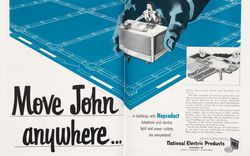
Controlling Comfort
Controlling Comfort
Actions:
Text by Manfredo di Robilant
Issue:
The rest of your senses
The rest of your senses
Keyword(s):
20th century, advertisement, air conditioning, American Iron and Steel Institute, Amérique du Nord, Architectural Forum, Architectural Review, Chrysler, climatisation, Committee on Steel Pipe Research, États-Unis, House Beautiful, Manfredo di Robilant, National Electric Products, North America, Progressive Architecture, publication, publicité, Seconde Guerre mondiale, Second World War, technologie, technology, United States, XXe siècle
20th century, advertisement, air conditioning, American Iron and Steel Institute, Amérique du Nord, Architectural Forum, Architectural Review, Chrysler, climatisation, Committee on Steel Pipe Research, États-Unis, House Beautiful, Manfredo di Robilant, National Electric Products, North America, Progressive Architecture, publication, publicité, Seconde Guerre mondiale, Second World War, technologie, technology, United States, XXe siècle
Published:
1 October 2012
1 October 2012
Issue:
The rest of your senses
The rest of your senses
Form:
drawings
drawings
Actions:
Reference number:
AP154.S1.1973.PR01.SS2.037
Description:
Thirty-one drawings numbered 1 through 20 and 99 through 109. Drawings include floor plans, roof bulkheads, roof paving and roof railing details, north and west elevations, south and east elevations, core plans, door and frame details.
AP154.S1.1973.PR01.SS2.037
Description:
Thirty-one drawings numbered 1 through 20 and 99 through 109. Drawings include floor plans, roof bulkheads, roof paving and roof railing details, north and west elevations, south and east elevations, core plans, door and frame details.
People:
Date:
1955-1957
1955-1957
Title:
Copies of drawings for the Seagram Building, 375 Park Avenue, New York, N.Y.
Actions:
AP154.S1.1973.PR01.SS2.037
Description:
Thirty-one drawings numbered 1 through 20 and 99 through 109. Drawings include floor plans, roof bulkheads, roof paving and roof railing details, north and west elevations, south and east elevations, core plans, door and frame details.
Form:
drawings
drawings
Date:
1955-1957
1955-1957
People:
Form:
photographs
photographs
Reference number:
PH1980:0008:043
Description:
- Artists' inscription (Bourne & Shepherd) is cropped-LR on photograph "1353. Delhi the Juma Musjid from N.E." is written beneath photograph probably by Catherine Evans in 1980. - The Jami Masjid is seen from the north east side in the photograph.
PH1980:0008:043
Description:
- Artists' inscription (Bourne & Shepherd) is cropped-LR on photograph "1353. Delhi the Juma Musjid from N.E." is written beneath photograph probably by Catherine Evans in 1980. - The Jami Masjid is seen from the north east side in the photograph.
People:
Subject:
architecture
architecture
Date:
1866
1866
Title:
View of the Jami Masjid, Delhi (now Delhi Union Territory), India
Actions:
PH1980:0008:043
Description:
- Artists' inscription (Bourne & Shepherd) is cropped-LR on photograph "1353. Delhi the Juma Musjid from N.E." is written beneath photograph probably by Catherine Evans in 1980. - The Jami Masjid is seen from the north east side in the photograph.
Form:
photographs
photographs
Date:
1866
1866
People:
Subject:
architecture
architecture
Form:
works of art
works of art
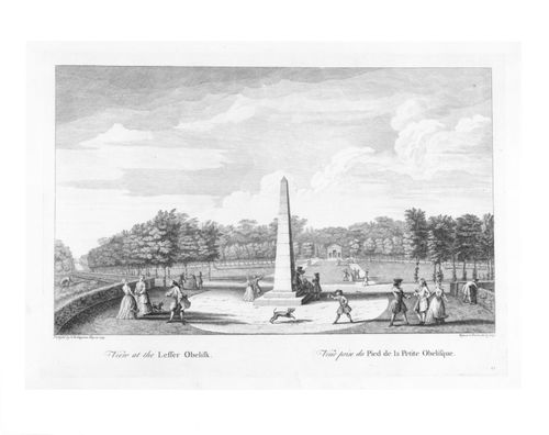
Title:
View at the Lesser Obelisk
View at the Lesser Obelisk
Actions:
Reference number:
DR1982:0096:013
Description:
- A view of the garden looking north, with Coucher's Obelisk in the centre foreground and the Brick Temple in the middle distance. - The marbled and leather-edged portfolio in which the prints were acquired is stored separately in a solander box (size IV).
DR1982:0096:013
Description:
- A view of the garden looking north, with Coucher's Obelisk in the centre foreground and the Brick Temple in the middle distance. - The marbled and leather-edged portfolio in which the prints were acquired is stored separately in a solander box (size IV).
People:
Subject:
architecture, landscape architecture, topographic
architecture, landscape architecture, topographic
Date:
designed 1733-1738
designed 1733-1738
Title:
View at the Lesser Obelisk
Actions:
DR1982:0096:013
Description:
- A view of the garden looking north, with Coucher's Obelisk in the centre foreground and the Brick Temple in the middle distance. - The marbled and leather-edged portfolio in which the prints were acquired is stored separately in a solander box (size IV).
Form:
works of art
works of art
Date:
designed 1733-1738
designed 1733-1738
People:
Subject:
architecture, landscape architecture, topographic
architecture, landscape architecture, topographic
Level of archival description:
Project
Project
Reference number:
AP056.S1.1994.PR03
Description:
This project series documents a park in Oakville, Ontario in 1994. The office identified the project number as 9401. This project was the winning entry in a competition to design a park in an area known as the Uptown Core, which was undergoing major transformations at the time. The park, now known as Oak Park, stretched several blocks north-east from the Sixth Line. The large part of the design included a greenhouse pavilion overlooking a lake, accompanied by a bridge that extended south-west towards a wooded area. The project is recorded through drawings and presentation watercolour paintings dating from around 1994. The drawings are mostly originals and primarily include site surveys, sketches, plans, elevations and perspectives.
People:
Date:
circa 1994
circa 1994
Title:
Oakville Parks, Oakville, Ontario (1994)
Actions:
AP056.S1.1994.PR03
Description:
This project series documents a park in Oakville, Ontario in 1994. The office identified the project number as 9401. This project was the winning entry in a competition to design a park in an area known as the Uptown Core, which was undergoing major transformations at the time. The park, now known as Oak Park, stretched several blocks north-east from the Sixth Line. The large part of the design included a greenhouse pavilion overlooking a lake, accompanied by a bridge that extended south-west towards a wooded area. The project is recorded through drawings and presentation watercolour paintings dating from around 1994. The drawings are mostly originals and primarily include site surveys, sketches, plans, elevations and perspectives.
Level of archival description:
Project
Project
Date:
circa 1994
circa 1994
People:
Form:
photographs
photographs
Actions:
Reference number:
PH1984:1203:019
Description:
- This photograph was taken from Penha Hill, looking north. Monte Fort is visible at centre left, the Cathedral at centre, Guia Fort and the lighthouse on the peak at centre right and the barracks at the edge of the view, centre right.
PH1984:1203:019
Description:
- This photograph was taken from Penha Hill, looking north. Monte Fort is visible at centre left, the Cathedral at centre, Guia Fort and the lighthouse on the peak at centre right and the barracks at the edge of the view, centre right.
People:
Subject:
architecture, topographic
architecture, topographic
Date:
between 1872 and 1887
between 1872 and 1887
Title:
Panoramic view of the Inner Harbour and Praya Grande showing Monte Fort, the Cathedral, Guia Fort and barracks, Macau (now Macau, China)
Actions:
PH1984:1203:019
Description:
- This photograph was taken from Penha Hill, looking north. Monte Fort is visible at centre left, the Cathedral at centre, Guia Fort and the lighthouse on the peak at centre right and the barracks at the edge of the view, centre right.
Form:
photographs
photographs
Date:
between 1872 and 1887
between 1872 and 1887
People:
Subject:
architecture, topographic
architecture, topographic