5646 Results
Level of archival description:
Project
Project
Title:
G.T.R.
G.T.R.
Actions:
Reference number:
AP144.S2.D97
Description:
File documents Cedric Price's involvement with the Grays Thurrock Working Party, with respect to land use and reclamation at Grays, Thurrock, England. David Keddie a former Cedric Price client (see AP144.S2.D84 and AP144.S2.D85) was also involved in the Working Party. Cedric Price also requested permission from the Thurrock Borough Council to use a chalk pit in the area as a test bed for siting elements for Generator (AP144.S2.D100). Material in this file was produced between 1974 and 1985, but predominant between 1975 and 1978. File contains photographic material and textual records.
People:
Date:
1974-1985, predominant 1975-1978
1974-1985, predominant 1975-1978
Title:
G.T.R.
Actions:
AP144.S2.D97
Description:
File documents Cedric Price's involvement with the Grays Thurrock Working Party, with respect to land use and reclamation at Grays, Thurrock, England. David Keddie a former Cedric Price client (see AP144.S2.D84 and AP144.S2.D85) was also involved in the Working Party. Cedric Price also requested permission from the Thurrock Borough Council to use a chalk pit in the area as a test bed for siting elements for Generator (AP144.S2.D100). Material in this file was produced between 1974 and 1985, but predominant between 1975 and 1978. File contains photographic material and textual records.
Level of archival description:
File 97
File 97
Date:
1974-1985, predominant 1975-1978
1974-1985, predominant 1975-1978
People:
Form:
drawings
drawings
Actions:
Reference number:
DR1988:0142
Description:
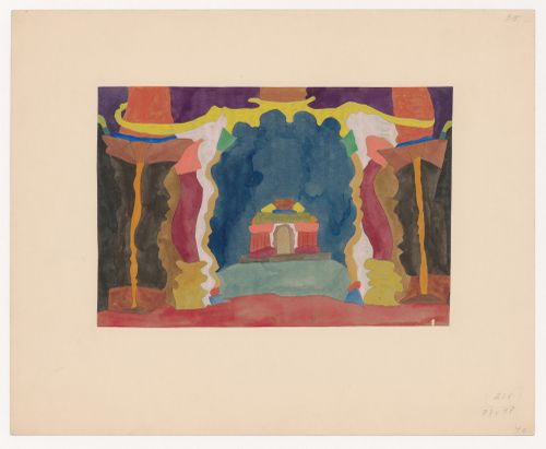
- Interpretation of the design depends on whether the blue and green areas represent sky and land; if so, this drawing could be interpreted as a view through the doorway of one building to the front elevation of another.
DR1988:0142
Description:
- Interpretation of the design depends on whether the blue and green areas represent sky and land; if so, this drawing could be interpreted as a view through the doorway of one building to the front elevation of another.
People:
Subject:
architecture
architecture
Date:
circa 1920-1921
circa 1920-1921
Title:
Imaginary view from one building to another
Actions:
DR1988:0142
Description:
- Interpretation of the design depends on whether the blue and green areas represent sky and land; if so, this drawing could be interpreted as a view through the doorway of one building to the front elevation of another.
Imaginary view from one building to another
Actions:
DR1988:0142
Description:
- Interpretation of the design depends on whether the blue and green areas represent sky and land; if so, this drawing could be interpreted as a view through the doorway of one building to the front elevation of another.
Form:
drawings
drawings
Date:
circa 1920-1921
circa 1920-1921
People:
Subject:
architecture
architecture
Form:
drawings
Quantity:
31 File
drawings
Quantity:
31 File
Actions:
Reference number:
ARCH79755
Description:
early sketch plans, plan of gun emplacements, site / floor plan, elevation study, building sections, sketch details, perspective of gallery and plan of column placements, site plan showing gun emplacements with land contours and levels
ARCH79755
Description:
early sketch plans, plan of gun emplacements, site / floor plan, elevation study, building sections, sketch details, perspective of gallery and plan of column placements, site plan showing gun emplacements with land contours and levels
People:
Date:
circa 1947-2002
circa 1947-2002
Title:
Early sketch plans, plan of gun emplacements, site / floor plan
Actions:
ARCH79755
Description:
early sketch plans, plan of gun emplacements, site / floor plan, elevation study, building sections, sketch details, perspective of gallery and plan of column placements, site plan showing gun emplacements with land contours and levels
Form:
drawings
Quantity:
31 File
drawings
Quantity:
31 File
Date:
circa 1947-2002
circa 1947-2002
People:
Form:
drawings
Quantity:
19 File
drawings
Quantity:
19 File
Actions:
Reference number:
ARCH79710
Description:
floor plans showing relationship between gun emplacement and exhibition areas, sketch plans of parking area, plans of building footprints with land contours, sketch details with calculations, elevations, front entry plan showing storage modes and circulation
ARCH79710
Description:
floor plans showing relationship between gun emplacement and exhibition areas, sketch plans of parking area, plans of building footprints with land contours, sketch details with calculations, elevations, front entry plan showing storage modes and circulation
People:
Date:
circa 1947-2002
circa 1947-2002
Title:
Floor plans showing relationship between gun emplacement and exhibition areas
Actions:
ARCH79710
Description:
floor plans showing relationship between gun emplacement and exhibition areas, sketch plans of parking area, plans of building footprints with land contours, sketch details with calculations, elevations, front entry plan showing storage modes and circulation
Form:
drawings
Quantity:
19 File
drawings
Quantity:
19 File
Date:
circa 1947-2002
circa 1947-2002
People:
Form:
drawings
drawings
Actions:
Reference number:
ARCH33295
Description:
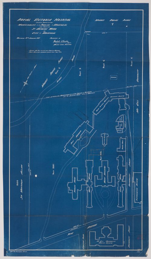
Drawing 8518 Royal Victoria Hospital, situate partly in the municipality of the parish of Montreal and partly in St Antoine ward now City of Montreal, MOntreal 10th January 1927, prepared by Malcolm D. Barclay, Q.L.S., Quebec land surveyor
ARCH33295
Description:
Drawing 8518 Royal Victoria Hospital, situate partly in the municipality of the parish of Montreal and partly in St Antoine ward now City of Montreal, MOntreal 10th January 1927, prepared by Malcolm D. Barclay, Q.L.S., Quebec land surveyor
People:
Date:
1927
1927
Title:
Royal Victoria Hospital, Montréal, Québec: cadastral plan
Actions:
ARCH33295
Description:
Drawing 8518 Royal Victoria Hospital, situate partly in the municipality of the parish of Montreal and partly in St Antoine ward now City of Montreal, MOntreal 10th January 1927, prepared by Malcolm D. Barclay, Q.L.S., Quebec land surveyor
Form:
drawings
drawings
Date:
1927
1927
People:
Form:
drawings
Quantity:
62 conceptual drawing(s)
drawings
Quantity:
62 conceptual drawing(s)
Actions:
Reference number:
DR2004:0897
Description:
elevations, some with annotations, sections, sketches, perspectives, engineer's drawings, views of railway bridges, views of site, photomontages, design development drawings, postcards, montages, presentation drawings, details, maps, overlays, notes, clippings, land survey, plan, site plan, and diagram
People:
Title:
Elevations, some with annotations, sections, sketches
Actions:
DR2004:0897
Description:
elevations, some with annotations, sections, sketches, perspectives, engineer's drawings, views of railway bridges, views of site, photomontages, design development drawings, postcards, montages, presentation drawings, details, maps, overlays, notes, clippings, land survey, plan, site plan, and diagram
Form:
drawings
Quantity:
62 conceptual drawing(s)
drawings
Quantity:
62 conceptual drawing(s)
People:
Level of archival description:
Project
Project
Reference number:
AP027.S1.D34
Description:
This project series documents a series of commissions to study the various requirements for the future of the Montréal International Airport given the increase in traffic and potential future technological innovations in aviation. Van Ginkel Associates looked at three options: expanding the airport located in Dorval; abandonning Dorval as a site completely; and keeping the Dorval location and adding another airport at a new site. In their study they included future operations, systems, and the impact on the region, including site selection studies, studies of industrial and commercial development related to the airport, and its anticipated activity. Proposals for land use and the reorganization of the territory surrounding the new site were also presented.
People:
Date:
1966-1968
1966-1968
Title:
Montréal International Airport, Montréal (1966-1968)
Actions:
AP027.S1.D34
Description:
This project series documents a series of commissions to study the various requirements for the future of the Montréal International Airport given the increase in traffic and potential future technological innovations in aviation. Van Ginkel Associates looked at three options: expanding the airport located in Dorval; abandonning Dorval as a site completely; and keeping the Dorval location and adding another airport at a new site. In their study they included future operations, systems, and the impact on the region, including site selection studies, studies of industrial and commercial development related to the airport, and its anticipated activity. Proposals for land use and the reorganization of the territory surrounding the new site were also presented.
Level of archival description:
File 34
File 34
Date:
1966-1968
1966-1968
People:
Level of archival description:
Project
Project
Actions:
Reference number:
AP056.S1.1995.PR07
Description:
This project series documents a proposed mixed-use development at the corner of Phoebe and Soho Streets in Toronto from 1995-1997. The office identified the project number as 9513. This project proposed a large development on approximately 75,000 square feet of land that would host condominiums, parking areas, common outdoor spaces, retail and other amenities. Several schemes were examined that varied in the number of buildings, their configuration on the site, and on specific amenities that would be provided. The project was commissioned by The Wittington Group, but was never built. The project is recorded through drawings, a presentation painting and some accompanying textual records dating from 1995-1997. The drawings are mostly original sketches and presentation drawings.
People:
Date:
1995-1997
1995-1997
Title:
SOHO/Phoebe, Toronto (1995-1997)
Actions:
AP056.S1.1995.PR07
Description:
This project series documents a proposed mixed-use development at the corner of Phoebe and Soho Streets in Toronto from 1995-1997. The office identified the project number as 9513. This project proposed a large development on approximately 75,000 square feet of land that would host condominiums, parking areas, common outdoor spaces, retail and other amenities. Several schemes were examined that varied in the number of buildings, their configuration on the site, and on specific amenities that would be provided. The project was commissioned by The Wittington Group, but was never built. The project is recorded through drawings, a presentation painting and some accompanying textual records dating from 1995-1997. The drawings are mostly original sketches and presentation drawings.
Level of archival description:
Project
Project
Date:
1995-1997
1995-1997
People:
Form:
drawings
Quantity:
34 File
drawings
Quantity:
34 File
Actions:
Reference number:
ARCH79789
Description:
early schematic plan sketches and building sections showing variations in design concept, north elevation studies, sketch plans and details, schematic plan showing square footages and ramp section with attached sheet of calculations, site and ste / floor plans showing land contours
People:
Date:
circa 1947-2002
circa 1947-2002
Title:
Early schematic plan sketches and building sections showing variations in design concept
Actions:
ARCH79789
Description:
early schematic plan sketches and building sections showing variations in design concept, north elevation studies, sketch plans and details, schematic plan showing square footages and ramp section with attached sheet of calculations, site and ste / floor plans showing land contours
Form:
drawings
Quantity:
34 File
drawings
Quantity:
34 File
Date:
circa 1947-2002
circa 1947-2002
People:
Level of archival description:
Sub-series
Sub-series
Actions:
Reference number:
AP178.S1.1998.PR03.SS2
Description:
This project subseries documents the Caja Rural de Granada in the Edifício Zaida in Granada, Spain. While the records were held in the office’s archives this project was assigned the number 98/90 B. The office assigned the dates 1998-2006 to this project subseries. This was part of phase 1 of the larger project to redevelop three parcels of land that faced the Plaza Puerta Real. This part of the project consisted of a bank branch for Caja Rural located on the ground level of the larger Zaida building. Documenting this project subseries are drawings and textual records dating from 2002-2005. The textual records include supplier catalogues, contract details, correspondence and documentation on the interiors. The drawings include plans, sketches, mechanical drawings and details.
People:
Date:
2002-2005
2002-2005
Title:
Edifício Zaida, "Caja Rural de Granada" [Zaida building, "Caja Rural de Granada"], Granada, Spain (1998-2006)
Actions:
AP178.S1.1998.PR03.SS2
Description:
This project subseries documents the Caja Rural de Granada in the Edifício Zaida in Granada, Spain. While the records were held in the office’s archives this project was assigned the number 98/90 B. The office assigned the dates 1998-2006 to this project subseries. This was part of phase 1 of the larger project to redevelop three parcels of land that faced the Plaza Puerta Real. This part of the project consisted of a bank branch for Caja Rural located on the ground level of the larger Zaida building. Documenting this project subseries are drawings and textual records dating from 2002-2005. The textual records include supplier catalogues, contract details, correspondence and documentation on the interiors. The drawings include plans, sketches, mechanical drawings and details.
Level of archival description:
Project
Project
Date:
2002-2005
2002-2005
People: