34818 Results
Form:
drawings
drawings
Actions:
Reference number:
AP046.S1.1983.PR02.106
Description:
This file includes a reprographic copy of Plunkett and Brady map from 1873 highlighting the Lachine Canal.
AP046.S1.1983.PR02.106
Description:
This file includes a reprographic copy of Plunkett and Brady map from 1873 highlighting the Lachine Canal.
People:
Date:
1983-1992
1983-1992
Title:
Historical map of the Lachine Canal, Old Port of Montreal Master Plan, Montréal, Québec
Actions:
AP046.S1.1983.PR02.106
Description:
This file includes a reprographic copy of Plunkett and Brady map from 1873 highlighting the Lachine Canal.
Historical map of the Lachine Canal, Old Port of Montreal Master Plan, Montréal, Québec
Actions:
AP046.S1.1983.PR02.106
Description:
This file includes a reprographic copy of Plunkett and Brady map from 1873 highlighting the Lachine Canal.
Form:
drawings
drawings
Date:
1983-1992
1983-1992
People:
Form:
drawings, textual records
drawings, textual records
Reference number:
DR2004:0335
Description:
competition programme, brochures, correspondence, sketches, notes, drawing, letter from Frank Newby, and map of downtown Sheffield, England
DR2004:0335
Description:
competition programme, brochures, correspondence, sketches, notes, drawing, letter from Frank Newby, and map of downtown Sheffield, England
People:
Title:
Competition programme, brochures, correspondence, sketches, notes, drawing, letter from Frank Newby, and map
Actions:
DR2004:0335
Description:
competition programme, brochures, correspondence, sketches, notes, drawing, letter from Frank Newby, and map of downtown Sheffield, England
Competition programme, brochures, correspondence, sketches, notes, drawing, letter from Frank Newby, and map
Actions:
DR2004:0335
Description:
competition programme, brochures, correspondence, sketches, notes, drawing, letter from Frank Newby, and map of downtown Sheffield, England
Form:
drawings, textual records
drawings, textual records
People:
Form:
maps
maps
Actions:
Reference number:
AP140.S2.SS1.D16.P1
Description:
photocopy of a hand-drawn map of Hyde Park and its immediate surroundings in London, indicating the location of the site
AP140.S2.SS1.D16.P1
Description:
photocopy of a hand-drawn map of Hyde Park and its immediate surroundings in London, indicating the location of the site
People:
Title:
Photocopy of a hand-drawn map of Hyde Park and its immediate surroundings in London
Actions:
AP140.S2.SS1.D16.P1
Description:
photocopy of a hand-drawn map of Hyde Park and its immediate surroundings in London, indicating the location of the site
Photocopy of a hand-drawn map of Hyde Park and its immediate surroundings in London
Actions:
AP140.S2.SS1.D16.P1
Description:
photocopy of a hand-drawn map of Hyde Park and its immediate surroundings in London, indicating the location of the site
Form:
maps
maps
People:
Form:
drawings
drawings
Title:
Site plan, plans, sections, details and cadastral map, Abando Passenger Interchange, Bilbao, Spain
Site plan, plans, sections, details and cadastral map, Abando Passenger Interchange, Bilbao, Spain
Actions:
Reference number:
AP140.S2.SS1.D70.P148
Description:
Site plan, plans, sections, details and cadastral map for second Abando Passenger Interchange project, including for parking garage, housing, utilities and plumbing systems
AP140.S2.SS1.D70.P148
Description:
Site plan, plans, sections, details and cadastral map for second Abando Passenger Interchange project, including for parking garage, housing, utilities and plumbing systems
People:
Date:
circa 1974-1999
circa 1974-1999
Title:
Site plan, plans, sections, details and cadastral map, Abando Passenger Interchange, Bilbao, Spain
Actions:
AP140.S2.SS1.D70.P148
Description:
Site plan, plans, sections, details and cadastral map for second Abando Passenger Interchange project, including for parking garage, housing, utilities and plumbing systems
Form:
drawings
drawings
Date:
circa 1974-1999
circa 1974-1999
People:
Form:
maps, textual records
maps, textual records
Reference number:
DR2004:1225
Description:
map and six copies of report 'Two Tree Island Project for David Keddie, Consultant's Report' (1972) by Yorke Rosenberg Mardall Architects and Cedric Price
DR2004:1225
Description:
map and six copies of report 'Two Tree Island Project for David Keddie, Consultant's Report' (1972) by Yorke Rosenberg Mardall Architects and Cedric Price
People:
Title:
Map and copies of report 'Two Tree Island Project for David Keddie, Consultant's Report'
Actions:
DR2004:1225
Description:
map and six copies of report 'Two Tree Island Project for David Keddie, Consultant's Report' (1972) by Yorke Rosenberg Mardall Architects and Cedric Price
Map and copies of report 'Two Tree Island Project for David Keddie, Consultant's Report'
Actions:
DR2004:1225
Description:
map and six copies of report 'Two Tree Island Project for David Keddie, Consultant's Report' (1972) by Yorke Rosenberg Mardall Architects and Cedric Price
Form:
maps, textual records
maps, textual records
People:
Form:
drawings, photographs
drawings, photographs
Title:
Sketches, drawings, a map, photographs, correspondence, labels for drawings, and a business card
Sketches, drawings, a map, photographs, correspondence, labels for drawings, and a business card
Actions:
Reference number:
AP142.S1.D175.P1
AP142.S1.D175.P1
People:
Title:
Sketches, drawings, a map, photographs, correspondence, labels for drawings, and a business card
Actions:
AP142.S1.D175.P1
Sketches, drawings, a map, photographs, correspondence, labels for drawings, and a business card
Actions:
AP142.S1.D175.P1
Form:
drawings, photographs
drawings, photographs
People:
Form:
drawings
drawings
Actions:
Reference number:
ARCH259309
ARCH259309
People:
Date:
circa 1984
circa 1984
Form:
drawings
drawings
Date:
circa 1984
circa 1984
People:
Form:
maps, drawings
maps, drawings
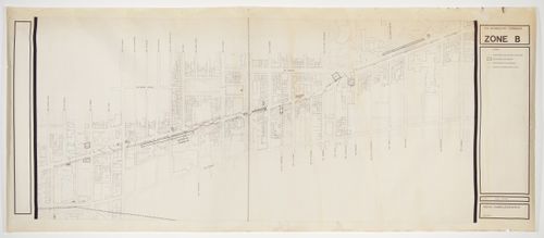
Title:
Map showing the location of installations along Sherbrooke Street, Corridart project, Montréal
Map showing the location of installations along Sherbrooke Street, Corridart project, Montréal
Actions:
Reference number:
DR1990:0067
DR1990:0067
People:
Subject:
temporary architecture
temporary architecture
Date:
May 1976
May 1976
Form:
maps, drawings
maps, drawings
Date:
May 1976
May 1976
People:
Subject:
temporary architecture
temporary architecture
Form:
maps, drawings
maps, drawings
Actions:
Reference number:
DR1995:0224:186
DR1995:0224:186
People:
Date:
1966
1966
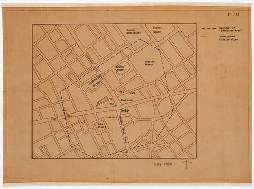
Title:
Map showing boundary of "immediate area" for Oxford Corner House, London, England
Actions:
DR1995:0224:186
Map showing boundary of "immediate area" for Oxford Corner House, London, England
Actions:
DR1995:0224:186
Form:
maps, drawings
maps, drawings
Date:
1966
1966
People:
Form:
maps, textual records
maps, textual records
Actions:
Reference number:
ARCH285194
ARCH285194
People:
Date:
1968
1968
Form:
maps, textual records
maps, textual records
Date:
1968
1968
People: