35106 Results
Form:
drawings
drawings
Actions:
Reference number:
AP018.S1.1971.PR07.015
AP018.S1.1971.PR07.015
People:
Date:
1971
1971
Form:
drawings
drawings
Date:
1971
1971
People:
Form:
drawings
drawings
Actions:
Reference number:
ARCH257053
ARCH257053
People:
Date:
circa 1987
circa 1987
Form:
drawings
drawings
Date:
circa 1987
circa 1987
People:
Form:
maps, drawings
maps, drawings
Actions:
Reference number:
DR1987:0421
Description:
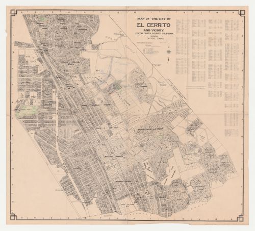
- The draughtsman used this map of El Cerrito as a base on which to sketch a site plan for Swedenborg Memorial Chapel which includes an outline of the church building, proposed roads, and possibly the future development of neighbouring properties. The parks in El Cerrito have been emphasized with green pencil.
DR1987:0421
Description:
- The draughtsman used this map of El Cerrito as a base on which to sketch a site plan for Swedenborg Memorial Chapel which includes an outline of the church building, proposed roads, and possibly the future development of neighbouring properties. The parks in El Cerrito have been emphasized with green pencil.
People:
Subject:
architecture, topographic
architecture, topographic
Date:
ca. 1955
ca. 1955
Title:
Swedenborg Memorial Chapel, El Cerrito, California: Sketch site plan on a map of the city of El Cerrito and vicinity
Actions:
DR1987:0421
Description:
- The draughtsman used this map of El Cerrito as a base on which to sketch a site plan for Swedenborg Memorial Chapel which includes an outline of the church building, proposed roads, and possibly the future development of neighbouring properties. The parks in El Cerrito have been emphasized with green pencil.
Form:
maps, drawings
maps, drawings
Date:
ca. 1955
ca. 1955
People:
Subject:
architecture, topographic
architecture, topographic
Form:
maps, textual records
maps, textual records
Actions:
Reference number:
AP206.S4.010
AP206.S4.010
People:
Date:
1963
1963
Form:
maps, textual records
maps, textual records
Date:
1963
1963
People:
Form:
drawings
drawings
Actions:
Reference number:
AP140.S2.SS1.D32.P1
Description:
topographical maps and surveys, cadastral maps, outline maps, contour maps, and other maps of North Kent and the North Downs; some of the maps are freehand, some are hand-coloured and some are reprographic copies, with or without added drawing or colour; many of the maps are annotated; also included are several topographic maps published by the United Kingdom Ordnance Survey
People:
Title:
Topographical maps and surveys, cadastral maps, outline maps
Actions:
AP140.S2.SS1.D32.P1
Description:
topographical maps and surveys, cadastral maps, outline maps, contour maps, and other maps of North Kent and the North Downs; some of the maps are freehand, some are hand-coloured and some are reprographic copies, with or without added drawing or colour; many of the maps are annotated; also included are several topographic maps published by the United Kingdom Ordnance Survey
Form:
drawings
drawings
People:
Form:
maps, drawings
maps, drawings
Actions:
Reference number:
DR2004:0266:003
DR2004:0266:003
People:
Date:
between 1966 and 1969
between 1966 and 1969
Form:
maps, drawings
maps, drawings
Date:
between 1966 and 1969
between 1966 and 1969
People:
Form:
drawings
drawings
Actions:
Reference number:
AP178.S1.1980.PR06.010
Description:
Original file title: Quinta Do Forno- Briteiros
AP178.S1.1980.PR06.010
Description:
Original file title: Quinta Do Forno- Briteiros
People:
Date:
July 1980
July 1980
Title:
Elevations, sections, floor plan, and topographic map, Casa J. M. Teixeira, Quinta do Forno, Briteiros - Guimarães
Actions:
AP178.S1.1980.PR06.010
Description:
Original file title: Quinta Do Forno- Briteiros
Elevations, sections, floor plan, and topographic map, Casa J. M. Teixeira, Quinta do Forno, Briteiros - Guimarães
Actions:
AP178.S1.1980.PR06.010
Description:
Original file title: Quinta Do Forno- Briteiros
Form:
drawings
drawings
Date:
July 1980
July 1980
People:
Form:
drawings
drawings
Reference number:
AP140.S2.SS3.D7.P4
AP140.S2.SS3.D7.P4
People:
Date:
circa 1977-1979
circa 1977-1979
Form:
drawings
drawings
Date:
circa 1977-1979
circa 1977-1979
People:
Form:
textual records
textual records
Title:
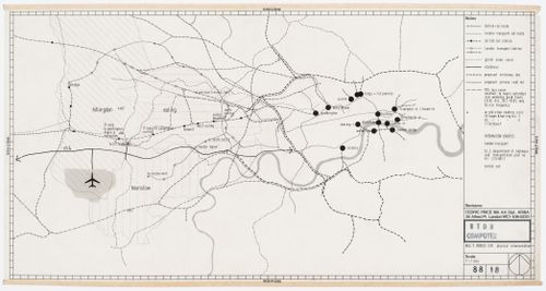
Cultural program and map of the Comune di Venezia, Recuperação da Área do Campo di Marte, Giudecca
Cultural program and map of the Comune di Venezia, Recuperação da Área do Campo di Marte, Giudecca
Actions:
Reference number:
AP178.S1.1985.PR02.SS1.011
Description:
Original file title: Venezia Almanacco Nota : Indicações Arq. Siza
AP178.S1.1985.PR02.SS1.011
Description:
Original file title: Venezia Almanacco Nota : Indicações Arq. Siza
People:
Date:
1984
1984
Title:
Cultural program and map of the Comune di Venezia, Recuperação da Área do Campo di Marte, Giudecca
Actions:
AP178.S1.1985.PR02.SS1.011
Description:
Original file title: Venezia Almanacco Nota : Indicações Arq. Siza
Cultural program and map of the Comune di Venezia, Recuperação da Área do Campo di Marte, Giudecca
Actions:
AP178.S1.1985.PR02.SS1.011
Description:
Original file title: Venezia Almanacco Nota : Indicações Arq. Siza
Form:
textual records
textual records
Date:
1984
1984
People:
Form:
drawings
drawings
Actions:
Reference number:
AP140.S2.SS1.D72.P1
AP140.S2.SS1.D72.P1
People:
Date:
circa 1982-1986
circa 1982-1986
Title:
Map, site plan, floor plans, elevations and sections of existing buildings, No. 1 Poultry, London, United Kingdom
Actions:
AP140.S2.SS1.D72.P1
Map, site plan, floor plans, elevations and sections of existing buildings, No. 1 Poultry, London, United Kingdom
Actions:
AP140.S2.SS1.D72.P1
Form:
drawings
drawings
Date:
circa 1982-1986
circa 1982-1986
People: