5328 Results
Form:
events
events
Title:
Siza Speaks
Siza Speaks
Actions:
Description:
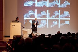
Portuguese architect and Pritzker prize-winner Álvaro Siza presents a rare lecture in North America on the design development of the Iberê Camargo Museum in Porto Alegre, a structure noted for its sculptural volumes and tight integration with a coastal escarpment. He discusses the key role of hand sketches in the design process, from massing studies to fine-tuning(...)
Portuguese architect and Pritzker prize-winner Álvaro Siza presents a rare lecture in North America on the design development of the Iberê Camargo Museum in Porto Alegre, a structure noted for its sculptural volumes and tight integration with a coastal escarpment. He discusses the key role of hand sketches in the design process, from massing studies to fine-tuning(...)
Location:
Paul-Desmarais Theater
Paul-Desmarais Theater
Date:
26 April 2012 , 7pm
26 April 2012 , 7pm
Title:
Siza Speaks
Actions:
Description:
Portuguese architect and Pritzker prize-winner Álvaro Siza presents a rare lecture in North America on the design development of the Iberê Camargo Museum in Porto Alegre, a structure noted for its sculptural volumes and tight integration with a coastal escarpment. He discusses the key role of hand sketches in the design process, from massing studies to fine-tuning(...)
Form:
events
events
Date:
26 April 2012
7pm
26 April 2012
7pm
Location:
Paul-Desmarais Theater
Paul-Desmarais Theater
Form:
drawings
drawings
Reference number:
ARCH7812
Description:
Perspectives de cartouches représentant les quatre évangélistes. Élévation d'une porte (dessin 5227-4) /Edgar Brandt, Paris.
ARCH7812
Description:
Perspectives de cartouches représentant les quatre évangélistes. Élévation d'une porte (dessin 5227-4) /Edgar Brandt, Paris.
People:
Date:
circa 1923
circa 1923
Title:
Perspectives de cartouches représentant les quatre évangélistes
Actions:
ARCH7812
Description:
Perspectives de cartouches représentant les quatre évangélistes. Élévation d'une porte (dessin 5227-4) /Edgar Brandt, Paris.
Perspectives de cartouches représentant les quatre évangélistes
Actions:
ARCH7812
Description:
Perspectives de cartouches représentant les quatre évangélistes. Élévation d'une porte (dessin 5227-4) /Edgar Brandt, Paris.
Form:
drawings
drawings
Date:
circa 1923
circa 1923
People:
Form:
drawings
drawings
Actions:
Reference number:
ARCH273603
Description:
Détails de la scène et de la porte de l'auditorium, de l'entrée principale et du toit de la tour. Détails de la finition du vestibule et de l'escalier sud.
ARCH273603
Description:
Détails de la scène et de la porte de l'auditorium, de l'entrée principale et du toit de la tour. Détails de la finition du vestibule et de l'escalier sud.
People:
Date:
circa 1948
circa 1948
Title:
Détails de la scène et de la porte de l'auditorium, Carr Hall, Saint-Michael's University
Actions:
ARCH273603
Description:
Détails de la scène et de la porte de l'auditorium, de l'entrée principale et du toit de la tour. Détails de la finition du vestibule et de l'escalier sud.
Détails de la scène et de la porte de l'auditorium, Carr Hall, Saint-Michael's University
Actions:
ARCH273603
Description:
Détails de la scène et de la porte de l'auditorium, de l'entrée principale et du toit de la tour. Détails de la finition du vestibule et de l'escalier sud.
Form:
drawings
drawings
Date:
circa 1948
circa 1948
People:
Form:
drawings
drawings
Actions:
Reference number:
ARCH273662
Description:
Détails des cadres de porte, du lettrage sur la première pierre, du plâtre du hall principal, de l'armature du toit et de l'ornementation des lucarnes.
ARCH273662
Description:
Détails des cadres de porte, du lettrage sur la première pierre, du plâtre du hall principal, de l'armature du toit et de l'ornementation des lucarnes.
People:
Date:
circa 1937
circa 1937
Title:
Détails des cadres de porte, du lettrage sur la première pierre
Actions:
ARCH273662
Description:
Détails des cadres de porte, du lettrage sur la première pierre, du plâtre du hall principal, de l'armature du toit et de l'ornementation des lucarnes.
Détails des cadres de porte, du lettrage sur la première pierre
Actions:
ARCH273662
Description:
Détails des cadres de porte, du lettrage sur la première pierre, du plâtre du hall principal, de l'armature du toit et de l'ornementation des lucarnes.
Form:
drawings
drawings
Date:
circa 1937
circa 1937
People:
Form:
textual records
textual records
Actions:
Reference number:
ARCH174243
Description:
Contient un document télécopié concernant les révisions apportées aux garde-corps et aux lampadaires (3 sept. 91), facture no 1: de Luc Laporte à la Société du Vieux-Port de Montréal (15 octobre 1991), devis de 91 pages 8.5” x 11” non reliées, 28 janvier 1992 , un document concernant les honoraires professionnels de l'équipe de Luc Laporte (6 mars 1992) et une lettre concernant la membrane de toit Hydrotech (8 juillet 1992).
People:
Date:
1991-1992
1991-1992
Title:
Devis, documents financiers, correspondance de chantier, et correspondance avec consultants et fournisseurs, Pavillon du Bassin Bonsecours, Montréal, Québec
Actions:
ARCH174243
Description:
Contient un document télécopié concernant les révisions apportées aux garde-corps et aux lampadaires (3 sept. 91), facture no 1: de Luc Laporte à la Société du Vieux-Port de Montréal (15 octobre 1991), devis de 91 pages 8.5” x 11” non reliées, 28 janvier 1992 , un document concernant les honoraires professionnels de l'équipe de Luc Laporte (6 mars 1992) et une lettre concernant la membrane de toit Hydrotech (8 juillet 1992).
Form:
textual records
textual records
Date:
1991-1992
1991-1992
People:
Reference number:
PH1978:0040.03
Description:
Third of a series of five illustrated volumes, this album contains mounted plates, engravings and maps (one map on two-pages), and depicts lock gates, dams, bridges, channels, subterraneans, aqueducs, canal-bridges, water towers and reservoirs in France. Album (Tome 3) is titled as follows: Les Travaux Publics de la France. Route et ponts - chemins de fer - rivières et canaux/ ports de mer - phares et balises/ par/ MM. F. Lucas et V. Fournié - Ed. Collignon - H. de Lagrené/ Voisin Bey - E. Allard/ ouvrage publié sous les auspices/ du Ministère des Travaux Publics et sous la direction de/ M. Léonce Reynaud/ Inspecteur général des Ponts et Chaussées/ Tome Troisième: Rivières et canaux/ Eaux des villes - Irrigations et assainissement des terres/ par/H. De Lagrené/ Ingénieur en Chef des Ponts et Chaussées/ avec 50 planches phototypées, 109 gravures et une carte en chromolithographie/ Paris/ J. Rothschild, Éditeur 13 rue des Saints-Pères, 13 M DCCC LXXXIII and the album is divided as follows: Rivières et Canaux - Introduction - Chapitre Premier. Historique de la navigation intérieure en France - Chapitre II. Considérations sur les voies navigables en particulier - Chapitre III. Navigation sur les rivières non canalisées - Chapitre IV. Canalisation en lit de rivière - Chapitre V. Canaux de navigation Deuxième Partie Alimentation en eau des villes - Chapitre Premier. Indications générales - Chapitre II. Travaux relatifs à l'alimentation en eau des villes - Chapitre III. Travaux relatifs à la distribution des eaux des villes - Chapitre IV. Travaux d'égout et de drainage des villes - Chapitre V. Utilisation des eaux d'égout - Chapitre VI. Alimentation en eau et assainissement de Paris Troisième Partie Emploi des eaux pour fertiliser les terres - Chapitre Premier. Considérations générales - Chapitre II. Approvisionnement des eaux d'irrigation - Chapitre III. Travaux relatifs à la conduite des eaux d'irrigation - Chapitre IV. Pratique des irrigations - Chapitre V. Colmatages Quatrième Partie Desséchement, drainage, travaux de défense contre les inondations - Chapitre Premier. Desséchements - Chapitre II. Drainage - Chapitre III. Des inondations - Explication des planches - Table des matières Plates are listed as follows: I Barrage de Seine-Port II Barrage duPort-à-l'Anglais III, IV et V Barrage de Port-Villez VI Portes de l'écluse de Bougival VII Écluse de la Boutonne VIII Port de Javel IX Pont de Ranville X Vue du canal latéral à la Garonne XI Prise d'eau du canal latéral à Toulouse XII Jonction du canal du Midi et du canal latéral à la Garonne XIII Écluses de Castets (Canal latéral à la Garonne) XIV Souterrain de Malpas (Canal du Midi) XV Écluse octuple de Fonserannes XVI Pont canal de Béziers XVII et XIII Réservoir de Lampy (Canal du Midi) XIX Réservoir de Saint-Ferréol (Canal du Midi) XX Écluse de Saint-Julien (Canal du centre) XXI Les sept écluses (Canal du centre) XXII Pont canal de la Bourbince (sur la rigole navigable de l'Arroux, canal du centre) XXIII Tranchée aux abords du souterrain de Pouilly (Canal de Bourgogne) XXIV Réservoir de Gros-Bois (Canal de Bourgogne) XXV Pont canal de Saint-Florentin (Canal de Bourgogne) XXVI Pont aqueduc de Montreillon (Canal du Nivernais) XXVII Pont canal du Guétin (Canal latéral à la Loire) XXVIII Pont canal de Barberey (Canal de la haute Seine) XXIX Traversée de la ville de Troyes par le Canal de la haute Seine XXX, XXXI, XXXII, XXXIII, XXXIV, XXXV, XXXVI et XXXVII Canal de Nantes à Brest XXXVIII Aqueduc de Roquefavour XXXIX Chateau-d'eau de Marseille XL, XLI, XLII, XLIII, XLIV et XLV Dérivation de la Vanne XLVI et XVII Distribution d'eau de Nice XLVIII Réservoir du Furens XLIX Réservoir de Ternay L Canal du Verdon
People:
Subject:
engineering
engineering
Date:
between 1876-1883
between 1876-1883
Title:
Les Travaux Publics de la France. Tome 3. Rivières et Canaux
Actions:
PH1978:0040.03
Description:
Third of a series of five illustrated volumes, this album contains mounted plates, engravings and maps (one map on two-pages), and depicts lock gates, dams, bridges, channels, subterraneans, aqueducs, canal-bridges, water towers and reservoirs in France. Album (Tome 3) is titled as follows: Les Travaux Publics de la France. Route et ponts - chemins de fer - rivières et canaux/ ports de mer - phares et balises/ par/ MM. F. Lucas et V. Fournié - Ed. Collignon - H. de Lagrené/ Voisin Bey - E. Allard/ ouvrage publié sous les auspices/ du Ministère des Travaux Publics et sous la direction de/ M. Léonce Reynaud/ Inspecteur général des Ponts et Chaussées/ Tome Troisième: Rivières et canaux/ Eaux des villes - Irrigations et assainissement des terres/ par/H. De Lagrené/ Ingénieur en Chef des Ponts et Chaussées/ avec 50 planches phototypées, 109 gravures et une carte en chromolithographie/ Paris/ J. Rothschild, Éditeur 13 rue des Saints-Pères, 13 M DCCC LXXXIII and the album is divided as follows: Rivières et Canaux - Introduction - Chapitre Premier. Historique de la navigation intérieure en France - Chapitre II. Considérations sur les voies navigables en particulier - Chapitre III. Navigation sur les rivières non canalisées - Chapitre IV. Canalisation en lit de rivière - Chapitre V. Canaux de navigation Deuxième Partie Alimentation en eau des villes - Chapitre Premier. Indications générales - Chapitre II. Travaux relatifs à l'alimentation en eau des villes - Chapitre III. Travaux relatifs à la distribution des eaux des villes - Chapitre IV. Travaux d'égout et de drainage des villes - Chapitre V. Utilisation des eaux d'égout - Chapitre VI. Alimentation en eau et assainissement de Paris Troisième Partie Emploi des eaux pour fertiliser les terres - Chapitre Premier. Considérations générales - Chapitre II. Approvisionnement des eaux d'irrigation - Chapitre III. Travaux relatifs à la conduite des eaux d'irrigation - Chapitre IV. Pratique des irrigations - Chapitre V. Colmatages Quatrième Partie Desséchement, drainage, travaux de défense contre les inondations - Chapitre Premier. Desséchements - Chapitre II. Drainage - Chapitre III. Des inondations - Explication des planches - Table des matières Plates are listed as follows: I Barrage de Seine-Port II Barrage duPort-à-l'Anglais III, IV et V Barrage de Port-Villez VI Portes de l'écluse de Bougival VII Écluse de la Boutonne VIII Port de Javel IX Pont de Ranville X Vue du canal latéral à la Garonne XI Prise d'eau du canal latéral à Toulouse XII Jonction du canal du Midi et du canal latéral à la Garonne XIII Écluses de Castets (Canal latéral à la Garonne) XIV Souterrain de Malpas (Canal du Midi) XV Écluse octuple de Fonserannes XVI Pont canal de Béziers XVII et XIII Réservoir de Lampy (Canal du Midi) XIX Réservoir de Saint-Ferréol (Canal du Midi) XX Écluse de Saint-Julien (Canal du centre) XXI Les sept écluses (Canal du centre) XXII Pont canal de la Bourbince (sur la rigole navigable de l'Arroux, canal du centre) XXIII Tranchée aux abords du souterrain de Pouilly (Canal de Bourgogne) XXIV Réservoir de Gros-Bois (Canal de Bourgogne) XXV Pont canal de Saint-Florentin (Canal de Bourgogne) XXVI Pont aqueduc de Montreillon (Canal du Nivernais) XXVII Pont canal du Guétin (Canal latéral à la Loire) XXVIII Pont canal de Barberey (Canal de la haute Seine) XXIX Traversée de la ville de Troyes par le Canal de la haute Seine XXX, XXXI, XXXII, XXXIII, XXXIV, XXXV, XXXVI et XXXVII Canal de Nantes à Brest XXXVIII Aqueduc de Roquefavour XXXIX Chateau-d'eau de Marseille XL, XLI, XLII, XLIII, XLIV et XLV Dérivation de la Vanne XLVI et XVII Distribution d'eau de Nice XLVIII Réservoir du Furens XLIX Réservoir de Ternay L Canal du Verdon
Date:
between 1876-1883
between 1876-1883
People:
Subject:
engineering
engineering
Level of archival description:
Project
Project
Title:
Two Tree Island
Two Tree Island
Reference number:
AP144.S2.D84
Description:
File documents an unexecuted project for Two Tree Island, the last uninhabited island in the Thames Estuary, in Essex, England. Cedric Price collaborated with Yorke Rosenberg Mardall Architects (YMR) on the project for client David Keddie, to develop a 178-hectare site on the island which encompassed both existing and reclaimed land, some of which was reserved under a trust for nature conservation. Early proposals showed residential areas, commercial, as well as, industrial zones, and facilities for recreation and leisure activities, including a marina. The final design proposed a much smaller residential area and harbour and included larger conservation and marshland areas in response to local concerns. The project was rejected and a portion of Two Tree Island was leased to the Nature Conservancy (NERC). An Appeal and Public Enquiry lodged by the client was subsequently indefinitely postponed. The architects produced several versions of a consultant's report, created a 'logbook' for the project, and published a brochure and promotional material for a public meeting. Existing conditions and reference material in the file includes maps of the area showing locations for a photo survey; Port of Authority of London plans showing water depths at various locations; a drawing of Marine Island, Essex; and a collage of photos of the area mounted on a board. Sketches by Cedric Price show development plans for the island and explore alternate "open" and "closed" configurations for the basin. Sketch sections show established maximum flood heights on the proposed schemes (see sketches in Works II, p. 86). A series of schematic drawings by YMR develop preliminary schemes exploring alternate layouts in relation to the primary basin configuration. A perspective drawing shows a view of the site from the main road to the island. Design development drawings include both original drawings and reprographic copies and include bird's-eye view perspective sketches; diagrams showing "domestic development" and projected "typical patterning"; and diagrammatic plans/charts showing existing and reclaimed areas, compatibility of activities, and degrees of accessibility (see typical diagram in Works II, p. 87). Other design development drawings include standard plans, sections and elevations, as well as site plans, land-use plans for the marina, plans showing alternate layouts for the marina dock, plans showing Thames tidal defences, site sections, and breakwater profiles. Working drawings for the marina by consulting engineers Sir Frederick Snow and Partners include survey plans, detailed sections illustrating the reinforcement and stabilization of the marine bed, and task sequencing diagrams and charts. Publication and presentation material includes photographs of rendered perspectives, over 18 watercolour renderings of Two Tree Island by Cedric Price, and a mock-up for a 13-page brochure or report summarizing the project. Many drawings are also included in the textual records, which also include Cedric Price's diary on the project. Some material in this file was published in 'Cedric Price-Works II' (London: Architectural Press, 1984), 72, 86-87. Material in this file was produced between 1963 and 1989, but predominantly between 1971 and 1974. Cedric Price's office lists the following firms as the main consultants for this project: Felix J. Samuely & Partners and Sir Frederick Snow & Partners, Consulting Engineers; Baker Wilkins & Smith, Quantity Surveyors; Prof. Peter Cowan, Director, Joint Unit for Planning Research; Prof. Peter Willmott, Director Institute of Community Studies; Prof. G. P. Wibberley, Professor of Countryside Planning, University of London; M. A. B. Boddington, Rural Planning Services. One drawing in DR1995:0255:011-021 is attributed to Costain Civil Engineering Ltd. File contains cartographic materials, conceptual drawings, design development drawings, presentation drawings, consultant drawings, model, and textual records.
People:
Date:
1963-1989, predominant 1971-1974
1963-1989, predominant 1971-1974
Title:
Two Tree Island
Actions:
AP144.S2.D84
Description:
File documents an unexecuted project for Two Tree Island, the last uninhabited island in the Thames Estuary, in Essex, England. Cedric Price collaborated with Yorke Rosenberg Mardall Architects (YMR) on the project for client David Keddie, to develop a 178-hectare site on the island which encompassed both existing and reclaimed land, some of which was reserved under a trust for nature conservation. Early proposals showed residential areas, commercial, as well as, industrial zones, and facilities for recreation and leisure activities, including a marina. The final design proposed a much smaller residential area and harbour and included larger conservation and marshland areas in response to local concerns. The project was rejected and a portion of Two Tree Island was leased to the Nature Conservancy (NERC). An Appeal and Public Enquiry lodged by the client was subsequently indefinitely postponed. The architects produced several versions of a consultant's report, created a 'logbook' for the project, and published a brochure and promotional material for a public meeting. Existing conditions and reference material in the file includes maps of the area showing locations for a photo survey; Port of Authority of London plans showing water depths at various locations; a drawing of Marine Island, Essex; and a collage of photos of the area mounted on a board. Sketches by Cedric Price show development plans for the island and explore alternate "open" and "closed" configurations for the basin. Sketch sections show established maximum flood heights on the proposed schemes (see sketches in Works II, p. 86). A series of schematic drawings by YMR develop preliminary schemes exploring alternate layouts in relation to the primary basin configuration. A perspective drawing shows a view of the site from the main road to the island. Design development drawings include both original drawings and reprographic copies and include bird's-eye view perspective sketches; diagrams showing "domestic development" and projected "typical patterning"; and diagrammatic plans/charts showing existing and reclaimed areas, compatibility of activities, and degrees of accessibility (see typical diagram in Works II, p. 87). Other design development drawings include standard plans, sections and elevations, as well as site plans, land-use plans for the marina, plans showing alternate layouts for the marina dock, plans showing Thames tidal defences, site sections, and breakwater profiles. Working drawings for the marina by consulting engineers Sir Frederick Snow and Partners include survey plans, detailed sections illustrating the reinforcement and stabilization of the marine bed, and task sequencing diagrams and charts. Publication and presentation material includes photographs of rendered perspectives, over 18 watercolour renderings of Two Tree Island by Cedric Price, and a mock-up for a 13-page brochure or report summarizing the project. Many drawings are also included in the textual records, which also include Cedric Price's diary on the project. Some material in this file was published in 'Cedric Price-Works II' (London: Architectural Press, 1984), 72, 86-87. Material in this file was produced between 1963 and 1989, but predominantly between 1971 and 1974. Cedric Price's office lists the following firms as the main consultants for this project: Felix J. Samuely & Partners and Sir Frederick Snow & Partners, Consulting Engineers; Baker Wilkins & Smith, Quantity Surveyors; Prof. Peter Cowan, Director, Joint Unit for Planning Research; Prof. Peter Willmott, Director Institute of Community Studies; Prof. G. P. Wibberley, Professor of Countryside Planning, University of London; M. A. B. Boddington, Rural Planning Services. One drawing in DR1995:0255:011-021 is attributed to Costain Civil Engineering Ltd. File contains cartographic materials, conceptual drawings, design development drawings, presentation drawings, consultant drawings, model, and textual records.
Level of archival description:
File 84
File 84
Date:
1963-1989, predominant 1971-1974
1963-1989, predominant 1971-1974
People:
Form:
drawings
drawings
Title:
Carnet de croquis
Carnet de croquis
Actions:
Reference number:
ARCH163839
Description:
- Carnet de croquis, noir - Croquis réalisés pendant le séjour à Rome (20 octobre 1988) - Dessins et notes relatifs à de nombreux projets montréalais, dont la Maison Coloniale et la boutique Food - "Bonne année Montréal", notes préparatoires pour un texte sur l'aménagement du Vieux-Port - Croquis préparatoires pour les dessins faisant partis des "Oeuvres du prix de Rome" (Section D) - Notes sur "le monument ultime" et "la mémoire virtuelle" - Rencontres d'atelier avec étudiants de l'UQAM (8 février 1990)
People:
Date:
octobre 1988-février 1990
octobre 1988-février 1990
Title:
Carnet de croquis
Actions:
ARCH163839
Description:
- Carnet de croquis, noir - Croquis réalisés pendant le séjour à Rome (20 octobre 1988) - Dessins et notes relatifs à de nombreux projets montréalais, dont la Maison Coloniale et la boutique Food - "Bonne année Montréal", notes préparatoires pour un texte sur l'aménagement du Vieux-Port - Croquis préparatoires pour les dessins faisant partis des "Oeuvres du prix de Rome" (Section D) - Notes sur "le monument ultime" et "la mémoire virtuelle" - Rencontres d'atelier avec étudiants de l'UQAM (8 février 1990)
Form:
drawings
drawings
Date:
octobre 1988-février 1990
octobre 1988-février 1990
People:
Form:
maps, textual records, photographs
maps, textual records, photographs
Reference number:
CD035.S1.1979.PR01.031
Description:
Also contains maps and photographs Ouagadougou, and photocopies of articles written by Coen Beeker on Ouagadougou, including the article "Au Revoir Tunis, Ouaga, Port Sudan, Addis Ababa" on his projects in Tunisia, Ethiopia, Burkina Faso and Sudan. Reports and photographic material include work of the Brigade Topographique Burkinabé, a private agency that had been commissioned to distribute the stones that were used to mark a plot for the spatial redesign of the Wagadogo and Nossin districts, later also in Tampouy.
People:
Date:
1980-2006
1980-2006
Title:
Reports, maps and photographs of the Ouagadougou suburbs restructuring project, Burkina Faso
Actions:
CD035.S1.1979.PR01.031
Description:
Also contains maps and photographs Ouagadougou, and photocopies of articles written by Coen Beeker on Ouagadougou, including the article "Au Revoir Tunis, Ouaga, Port Sudan, Addis Ababa" on his projects in Tunisia, Ethiopia, Burkina Faso and Sudan. Reports and photographic material include work of the Brigade Topographique Burkinabé, a private agency that had been commissioned to distribute the stones that were used to mark a plot for the spatial redesign of the Wagadogo and Nossin districts, later also in Tampouy.
Form:
maps, textual records, photographs
maps, textual records, photographs
Date:
1980-2006
1980-2006
People:
Level of archival description:
Sub-series
Sub-series
Actions:
Reference number:
AP156.S2.SS10.D1
Description:
Le dossier porte sur des documents de la famille Jeanneret. Le matériel dans ce dossier a été produit entre 1911 et 1935. Le dossier contient des documents textuels. File related to documents of the Jeanneret's family. The material in this file was produced between 1911 and 1935. The file contains textual records.
People:
Date:
1911-1935
1911-1935
Title:
Documents de famille = Family documents
Actions:
AP156.S2.SS10.D1
Description:
Le dossier porte sur des documents de la famille Jeanneret. Le matériel dans ce dossier a été produit entre 1911 et 1935. Le dossier contient des documents textuels. File related to documents of the Jeanneret's family. The material in this file was produced between 1911 and 1935. The file contains textual records.
Level of archival description:
Dossier 1
Dossier 1
Date:
1911-1935
1911-1935
People: