


31793 Results
Form:
events
events
Title:
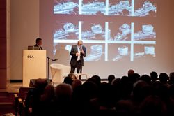
Siza Speaks
Siza Speaks
Actions:
Description:
Portuguese architect and Pritzker prize-winner Álvaro Siza presents a rare lecture in North America on the design development of the Iberê Camargo Museum in Porto Alegre, a structure noted for its sculptural volumes and tight integration with a coastal escarpment. He discusses the key role of hand sketches in the design process, from massing studies to fine-tuning(...)
Portuguese architect and Pritzker prize-winner Álvaro Siza presents a rare lecture in North America on the design development of the Iberê Camargo Museum in Porto Alegre, a structure noted for its sculptural volumes and tight integration with a coastal escarpment. He discusses the key role of hand sketches in the design process, from massing studies to fine-tuning(...)
Location:
Paul-Desmarais Theater
Paul-Desmarais Theater
Date:
26 April 2012 , 7pm
26 April 2012 , 7pm
Title:
Siza Speaks
Actions:
Description:
Portuguese architect and Pritzker prize-winner Álvaro Siza presents a rare lecture in North America on the design development of the Iberê Camargo Museum in Porto Alegre, a structure noted for its sculptural volumes and tight integration with a coastal escarpment. He discusses the key role of hand sketches in the design process, from massing studies to fine-tuning(...)
Siza Speaks
Actions:
Description:
Portuguese architect and Pritzker prize-winner Álvaro Siza presents a rare lecture in North America on the design development of the Iberê Camargo Museum in Porto Alegre, a structure noted for its sculptural volumes and tight integration with a coastal escarpment. He discusses the key role of hand sketches in the design process, from massing studies to fine-tuning(...)
Form:
events
events
Date:
26 April 2012
7pm
26 April 2012
7pm
Location:
Paul-Desmarais Theater
Paul-Desmarais Theater
Form:
photographs
photographs
Actions:
Reference number:
PH1980:1133
Description:
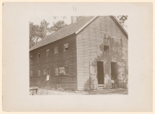
Photograph taken while Lewis Wickes Hine was working for the National Child Labor Committee. Caption from NCLC caption card: "Exterior of one of the shacks containing 24 rooms. Forsythe's Bog at Stop-the-Mode [sic] near Pemberton, N.J. This is the fourth week of school in Philadelphia and people will stay here two weeks more".
PH1980:1133
Description:
Photograph taken while Lewis Wickes Hine was working for the National Child Labor Committee. Caption from NCLC caption card: "Exterior of one of the shacks containing 24 rooms. Forsythe's Bog at Stop-the-Mode [sic] near Pemberton, N.J. This is the fourth week of school in Philadelphia and people will stay here two weeks more".
People:
Date:
September 1910
September 1910
Title:
Exterior view of wooden building containing twenty-four rooms occupied by cranberry pickers on Forsythe's Bog, with a small child seated in doorway, near Pemberton, New Jersey, United States
Actions:
PH1980:1133
Description:
Photograph taken while Lewis Wickes Hine was working for the National Child Labor Committee. Caption from NCLC caption card: "Exterior of one of the shacks containing 24 rooms. Forsythe's Bog at Stop-the-Mode [sic] near Pemberton, N.J. This is the fourth week of school in Philadelphia and people will stay here two weeks more".
Exterior view of wooden building containing twenty-four rooms occupied by cranberry pickers on Forsythe's Bog, with a small child seated in doorway, near Pemberton, New Jersey, United States
Actions:
PH1980:1133
Description:
Photograph taken while Lewis Wickes Hine was working for the National Child Labor Committee. Caption from NCLC caption card: "Exterior of one of the shacks containing 24 rooms. Forsythe's Bog at Stop-the-Mode [sic] near Pemberton, N.J. This is the fourth week of school in Philadelphia and people will stay here two weeks more".
Form:
photographs
photographs
Date:
September 1910
September 1910
People:
Form:
photographs
photographs
Reference number:
ARCH284095
Description:
Inclus des photographies du Grand Séminaire de Québec et de la Cour suprême du Canada. Contient les photographies numérotées P-4143 à P-4314.
ARCH284095
Description:
Inclus des photographies du Grand Séminaire de Québec et de la Cour suprême du Canada. Contient les photographies numérotées P-4143 à P-4314.
People:
Date:
1900s-1972
1900s-1972
Title:
Photographies de diverses œuvres d'art et de divers project de Cormier
Actions:
ARCH284095
Description:
Inclus des photographies du Grand Séminaire de Québec et de la Cour suprême du Canada. Contient les photographies numérotées P-4143 à P-4314.
Photographies de diverses œuvres d'art et de divers project de Cormier
Actions:
ARCH284095
Description:
Inclus des photographies du Grand Séminaire de Québec et de la Cour suprême du Canada. Contient les photographies numérotées P-4143 à P-4314.
Form:
photographs
photographs
Date:
1900s-1972
1900s-1972
People:
Form:
photographs
photographs
Title:
Photographies de divers projets d'Ernest Cormier, photographies de voyages et portraits de Cormier
Photographies de divers projets d'Ernest Cormier, photographies de voyages et portraits de Cormier
Actions:
Reference number:
ARCH284098
Description:
Includes photographies de la Bibliothèque du Barreau de Montréal, et du Campus de l'Université de Montréal. Contient les photographies numérotées P-5265 à P-5453.
ARCH284098
Description:
Includes photographies de la Bibliothèque du Barreau de Montréal, et du Campus de l'Université de Montréal. Contient les photographies numérotées P-5265 à P-5453.
People:
Date:
1900s-1972
1900s-1972
Title:
Photographies de divers projets d'Ernest Cormier, photographies de voyages et portraits de Cormier
Actions:
ARCH284098
Description:
Includes photographies de la Bibliothèque du Barreau de Montréal, et du Campus de l'Université de Montréal. Contient les photographies numérotées P-5265 à P-5453.
Photographies de divers projets d'Ernest Cormier, photographies de voyages et portraits de Cormier
Actions:
ARCH284098
Description:
Includes photographies de la Bibliothèque du Barreau de Montréal, et du Campus de l'Université de Montréal. Contient les photographies numérotées P-5265 à P-5453.
Form:
photographs
photographs
Date:
1900s-1972
1900s-1972
People:
Level of archival description:
Series
Series
Title:
Architectural projects
Architectural projects
Reference number:
AP166.S1
Description:
Series 1, Architectural Projects (1990-2012, predominant 1990-1996) contains files for seven projects developed by Shoei Yoh and the firm Shoei Yoh + Architects. Six of these projects were developed during the period 1990-1996 in Japan. The Galaxy Toyama Gymnasium in Imizu, Toyama Prefecture, Japan, is the most voluminous project file and is related to two other projects in the series—the Odawara Municipal Sports Complex and the Prospecta Toyama ’92 Observatory Tower. The Odawara Municipal Sports Complex and the Galaxy Toyama Gymnasium were developed at approximately the same time, and, for both projects, digital technology was used to calculate the dimensions of elements in a space frame roof structure. The Galaxy Toyama Gymnasium and the Prospecta Toyama ’92 Observatory Tower were both designed by Shoei Yoh for the 1st Japan Expo Toyama ’92 (JET ‘92) and each of the two project files contains some material related to the other. The Galaxy Toyama Gymnasium project contains CAD files related to the roof design, printouts from computer simulations of the roof, design drawings, presentation material, architectural and structural working drawings, models and textual records. The project file for the Odawara Municipal Sports Complex contains some design drawings--including printouts from computer simulations of the roof, proposal documents and some photographs of the site. The other built projects—the Prospecta Toyama ’92 Observatory Tower, the Glass Station, the Naiju Community Center and Nursery School, and the Uchino Community Center for Seniors and Children—are documented through drawings, models, and photographic material. The final project file in the series--a project for a tower in Taichung, Taiwan—is composed of a few presentation documents. Drawings in the series include hand drawings and printouts or photocopies of images created using digital design software. Apart from the CAD files related to the roof design for the Galaxy Toyama Gymnasium, digital material in the series is composed of still images in .jpg format related to the projects for the Odawara Municipal Sports Complex and the Galaxy Toyama Gymnasium. Some of the documents in .jpg format are duplicates of paper documents in the series.
AP166.S1
Description:
Series 1, Architectural Projects (1990-2012, predominant 1990-1996) contains files for seven projects developed by Shoei Yoh and the firm Shoei Yoh + Architects. Six of these projects were developed during the period 1990-1996 in Japan. The Galaxy Toyama Gymnasium in Imizu, Toyama Prefecture, Japan, is the most voluminous project file and is related to two other projects in the series—the Odawara Municipal Sports Complex and the Prospecta Toyama ’92 Observatory Tower. The Odawara Municipal Sports Complex and the Galaxy Toyama Gymnasium were developed at approximately the same time, and, for both projects, digital technology was used to calculate the dimensions of elements in a space frame roof structure. The Galaxy Toyama Gymnasium and the Prospecta Toyama ’92 Observatory Tower were both designed by Shoei Yoh for the 1st Japan Expo Toyama ’92 (JET ‘92) and each of the two project files contains some material related to the other. The Galaxy Toyama Gymnasium project contains CAD files related to the roof design, printouts from computer simulations of the roof, design drawings, presentation material, architectural and structural working drawings, models and textual records. The project file for the Odawara Municipal Sports Complex contains some design drawings--including printouts from computer simulations of the roof, proposal documents and some photographs of the site. The other built projects—the Prospecta Toyama ’92 Observatory Tower, the Glass Station, the Naiju Community Center and Nursery School, and the Uchino Community Center for Seniors and Children—are documented through drawings, models, and photographic material. The final project file in the series--a project for a tower in Taichung, Taiwan—is composed of a few presentation documents. Drawings in the series include hand drawings and printouts or photocopies of images created using digital design software. Apart from the CAD files related to the roof design for the Galaxy Toyama Gymnasium, digital material in the series is composed of still images in .jpg format related to the projects for the Odawara Municipal Sports Complex and the Galaxy Toyama Gymnasium. Some of the documents in .jpg format are duplicates of paper documents in the series.
People:
Date:
1990-2012, predominant 1990-1996
1990-2012, predominant 1990-1996
Title:
Architectural projects
Actions:
AP166.S1
Description:
Series 1, Architectural Projects (1990-2012, predominant 1990-1996) contains files for seven projects developed by Shoei Yoh and the firm Shoei Yoh + Architects. Six of these projects were developed during the period 1990-1996 in Japan. The Galaxy Toyama Gymnasium in Imizu, Toyama Prefecture, Japan, is the most voluminous project file and is related to two other projects in the series—the Odawara Municipal Sports Complex and the Prospecta Toyama ’92 Observatory Tower. The Odawara Municipal Sports Complex and the Galaxy Toyama Gymnasium were developed at approximately the same time, and, for both projects, digital technology was used to calculate the dimensions of elements in a space frame roof structure. The Galaxy Toyama Gymnasium and the Prospecta Toyama ’92 Observatory Tower were both designed by Shoei Yoh for the 1st Japan Expo Toyama ’92 (JET ‘92) and each of the two project files contains some material related to the other. The Galaxy Toyama Gymnasium project contains CAD files related to the roof design, printouts from computer simulations of the roof, design drawings, presentation material, architectural and structural working drawings, models and textual records. The project file for the Odawara Municipal Sports Complex contains some design drawings--including printouts from computer simulations of the roof, proposal documents and some photographs of the site. The other built projects—the Prospecta Toyama ’92 Observatory Tower, the Glass Station, the Naiju Community Center and Nursery School, and the Uchino Community Center for Seniors and Children—are documented through drawings, models, and photographic material. The final project file in the series--a project for a tower in Taichung, Taiwan—is composed of a few presentation documents. Drawings in the series include hand drawings and printouts or photocopies of images created using digital design software. Apart from the CAD files related to the roof design for the Galaxy Toyama Gymnasium, digital material in the series is composed of still images in .jpg format related to the projects for the Odawara Municipal Sports Complex and the Galaxy Toyama Gymnasium. Some of the documents in .jpg format are duplicates of paper documents in the series.
Architectural projects
Actions:
AP166.S1
Description:
Series 1, Architectural Projects (1990-2012, predominant 1990-1996) contains files for seven projects developed by Shoei Yoh and the firm Shoei Yoh + Architects. Six of these projects were developed during the period 1990-1996 in Japan. The Galaxy Toyama Gymnasium in Imizu, Toyama Prefecture, Japan, is the most voluminous project file and is related to two other projects in the series—the Odawara Municipal Sports Complex and the Prospecta Toyama ’92 Observatory Tower. The Odawara Municipal Sports Complex and the Galaxy Toyama Gymnasium were developed at approximately the same time, and, for both projects, digital technology was used to calculate the dimensions of elements in a space frame roof structure. The Galaxy Toyama Gymnasium and the Prospecta Toyama ’92 Observatory Tower were both designed by Shoei Yoh for the 1st Japan Expo Toyama ’92 (JET ‘92) and each of the two project files contains some material related to the other. The Galaxy Toyama Gymnasium project contains CAD files related to the roof design, printouts from computer simulations of the roof, design drawings, presentation material, architectural and structural working drawings, models and textual records. The project file for the Odawara Municipal Sports Complex contains some design drawings--including printouts from computer simulations of the roof, proposal documents and some photographs of the site. The other built projects—the Prospecta Toyama ’92 Observatory Tower, the Glass Station, the Naiju Community Center and Nursery School, and the Uchino Community Center for Seniors and Children—are documented through drawings, models, and photographic material. The final project file in the series--a project for a tower in Taichung, Taiwan—is composed of a few presentation documents. Drawings in the series include hand drawings and printouts or photocopies of images created using digital design software. Apart from the CAD files related to the roof design for the Galaxy Toyama Gymnasium, digital material in the series is composed of still images in .jpg format related to the projects for the Odawara Municipal Sports Complex and the Galaxy Toyama Gymnasium. Some of the documents in .jpg format are duplicates of paper documents in the series.
Level of archival description:
series
series
Date:
1990-2012, predominant 1990-1996
1990-2012, predominant 1990-1996
People:
Level of archival description:
Project
Project
Reference number:
AP206.S1.1975.PR01
Description:
This project series documents Aditya Prakash's proposal for an alternative plan for Chandigarh, India, which came to be known as the Linear City. Prakash began developing and advocating for this idea around the early 1970s. The Linear City had two fundamental ideas at its core. The first was to raise the roadways in Chandigarh (or any future city) 10-12 feet from ground level. This, he proposed, would separate vehicular traffic from pedestrians, eliminating all the hazardous impacts of traffic on daily life. The large part of the drawings for this project show sector plans and city blocks with evenly dispersed roundabout roadways as major transit hubs, wrapping around but high above centres of pedestrian activity that included shops, markets and green spaces. The sale of the land below the roadways would pay for the upheaval. He also recommended building this city only a few sectors deep, but endlessly expanding it length-wise, with a raised canal along one side to provide an additional transportation network and irrigation. The second fundamental idea of this city was the creation of self-sustaining sectors in the city plan, advocating that each neighbourhood should have the infrastructure to provide food and recycling for its residents. He fervently argued for the reimagination of modernist Chandigarh by incorporating sustainable, local traditions - the rural should exist in harmony with the urban. In opposition to Le Corbusier and Pierre Jeanneret, he believed areas for recycling, animal husbandry, and growing food should be incorporated into the fabric of the city.[1] This project is recorded largely through original drawings of city plans, perspectives and axonometric views detailing Prakash's new vision for the city. It seems that many of the perspectives were drawn by family friend Sandeep Virmani, after listening to Prakash's ideas.[2] The project is also recorded through photographs, negatives and slides showing plans and the project model. A small amount of notes and an article on the project are also included. [1]Vikramaditya Prakash, One Continuous Line: Art, Architecture and Urbanism of Aditya Prakash (Ahmedabad, India: Mapin Publishing Pvt. Ltd., 2019), 164-181. [2]Prakash, One Continuous Line, 169.
AP206.S1.1975.PR01
Description:
This project series documents Aditya Prakash's proposal for an alternative plan for Chandigarh, India, which came to be known as the Linear City. Prakash began developing and advocating for this idea around the early 1970s. The Linear City had two fundamental ideas at its core. The first was to raise the roadways in Chandigarh (or any future city) 10-12 feet from ground level. This, he proposed, would separate vehicular traffic from pedestrians, eliminating all the hazardous impacts of traffic on daily life. The large part of the drawings for this project show sector plans and city blocks with evenly dispersed roundabout roadways as major transit hubs, wrapping around but high above centres of pedestrian activity that included shops, markets and green spaces. The sale of the land below the roadways would pay for the upheaval. He also recommended building this city only a few sectors deep, but endlessly expanding it length-wise, with a raised canal along one side to provide an additional transportation network and irrigation. The second fundamental idea of this city was the creation of self-sustaining sectors in the city plan, advocating that each neighbourhood should have the infrastructure to provide food and recycling for its residents. He fervently argued for the reimagination of modernist Chandigarh by incorporating sustainable, local traditions - the rural should exist in harmony with the urban. In opposition to Le Corbusier and Pierre Jeanneret, he believed areas for recycling, animal husbandry, and growing food should be incorporated into the fabric of the city.[1] This project is recorded largely through original drawings of city plans, perspectives and axonometric views detailing Prakash's new vision for the city. It seems that many of the perspectives were drawn by family friend Sandeep Virmani, after listening to Prakash's ideas.[2] The project is also recorded through photographs, negatives and slides showing plans and the project model. A small amount of notes and an article on the project are also included. [1]Vikramaditya Prakash, One Continuous Line: Art, Architecture and Urbanism of Aditya Prakash (Ahmedabad, India: Mapin Publishing Pvt. Ltd., 2019), 164-181. [2]Prakash, One Continuous Line, 169.
People:
Date:
circa 1975-2003
circa 1975-2003
Title:
Linear city, Chandigarh, India (circa 1975-1987)
Actions:
AP206.S1.1975.PR01
Description:
This project series documents Aditya Prakash's proposal for an alternative plan for Chandigarh, India, which came to be known as the Linear City. Prakash began developing and advocating for this idea around the early 1970s. The Linear City had two fundamental ideas at its core. The first was to raise the roadways in Chandigarh (or any future city) 10-12 feet from ground level. This, he proposed, would separate vehicular traffic from pedestrians, eliminating all the hazardous impacts of traffic on daily life. The large part of the drawings for this project show sector plans and city blocks with evenly dispersed roundabout roadways as major transit hubs, wrapping around but high above centres of pedestrian activity that included shops, markets and green spaces. The sale of the land below the roadways would pay for the upheaval. He also recommended building this city only a few sectors deep, but endlessly expanding it length-wise, with a raised canal along one side to provide an additional transportation network and irrigation. The second fundamental idea of this city was the creation of self-sustaining sectors in the city plan, advocating that each neighbourhood should have the infrastructure to provide food and recycling for its residents. He fervently argued for the reimagination of modernist Chandigarh by incorporating sustainable, local traditions - the rural should exist in harmony with the urban. In opposition to Le Corbusier and Pierre Jeanneret, he believed areas for recycling, animal husbandry, and growing food should be incorporated into the fabric of the city.[1] This project is recorded largely through original drawings of city plans, perspectives and axonometric views detailing Prakash's new vision for the city. It seems that many of the perspectives were drawn by family friend Sandeep Virmani, after listening to Prakash's ideas.[2] The project is also recorded through photographs, negatives and slides showing plans and the project model. A small amount of notes and an article on the project are also included. [1]Vikramaditya Prakash, One Continuous Line: Art, Architecture and Urbanism of Aditya Prakash (Ahmedabad, India: Mapin Publishing Pvt. Ltd., 2019), 164-181. [2]Prakash, One Continuous Line, 169.
Linear city, Chandigarh, India (circa 1975-1987)
Actions:
AP206.S1.1975.PR01
Description:
This project series documents Aditya Prakash's proposal for an alternative plan for Chandigarh, India, which came to be known as the Linear City. Prakash began developing and advocating for this idea around the early 1970s. The Linear City had two fundamental ideas at its core. The first was to raise the roadways in Chandigarh (or any future city) 10-12 feet from ground level. This, he proposed, would separate vehicular traffic from pedestrians, eliminating all the hazardous impacts of traffic on daily life. The large part of the drawings for this project show sector plans and city blocks with evenly dispersed roundabout roadways as major transit hubs, wrapping around but high above centres of pedestrian activity that included shops, markets and green spaces. The sale of the land below the roadways would pay for the upheaval. He also recommended building this city only a few sectors deep, but endlessly expanding it length-wise, with a raised canal along one side to provide an additional transportation network and irrigation. The second fundamental idea of this city was the creation of self-sustaining sectors in the city plan, advocating that each neighbourhood should have the infrastructure to provide food and recycling for its residents. He fervently argued for the reimagination of modernist Chandigarh by incorporating sustainable, local traditions - the rural should exist in harmony with the urban. In opposition to Le Corbusier and Pierre Jeanneret, he believed areas for recycling, animal husbandry, and growing food should be incorporated into the fabric of the city.[1] This project is recorded largely through original drawings of city plans, perspectives and axonometric views detailing Prakash's new vision for the city. It seems that many of the perspectives were drawn by family friend Sandeep Virmani, after listening to Prakash's ideas.[2] The project is also recorded through photographs, negatives and slides showing plans and the project model. A small amount of notes and an article on the project are also included. [1]Vikramaditya Prakash, One Continuous Line: Art, Architecture and Urbanism of Aditya Prakash (Ahmedabad, India: Mapin Publishing Pvt. Ltd., 2019), 164-181. [2]Prakash, One Continuous Line, 169.
Level of archival description:
Project
Project
Date:
circa 1975-2003
circa 1975-2003
People:
Form:
photographs
photographs
Reference number:
ARCH158075
Description:
Série de 27 photographies noir et blanc, de petit format. Pour certaines de ces photographies, on peut retrouver le négatif dans la chemise 60-Ab03-02. Plusieurs de ces photographies sont également reproduites en format 8 x 10 dans les chemises 60-Ab04.
ARCH158075
Description:
Série de 27 photographies noir et blanc, de petit format. Pour certaines de ces photographies, on peut retrouver le négatif dans la chemise 60-Ab03-02. Plusieurs de ces photographies sont également reproduites en format 8 x 10 dans les chemises 60-Ab04.
People:
Date:
ca 1952-1953
ca 1952-1953
Title:
Photographies noir et blanc, de petit format
Actions:
ARCH158075
Description:
Série de 27 photographies noir et blanc, de petit format. Pour certaines de ces photographies, on peut retrouver le négatif dans la chemise 60-Ab03-02. Plusieurs de ces photographies sont également reproduites en format 8 x 10 dans les chemises 60-Ab04.
Photographies noir et blanc, de petit format
Actions:
ARCH158075
Description:
Série de 27 photographies noir et blanc, de petit format. Pour certaines de ces photographies, on peut retrouver le négatif dans la chemise 60-Ab03-02. Plusieurs de ces photographies sont également reproduites en format 8 x 10 dans les chemises 60-Ab04.
Form:
photographs
photographs
Date:
ca 1952-1953
ca 1952-1953
People:
Form:
born digital
born digital
Title:
3D models of the NSA Muscle
3D models of the NSA Muscle
Actions:
Reference number:
AP167.S1.SS2.004
Description:
This directory chiefly contains 3D drawings of the NSA Muscle. It also contains a small number of screenshots of the 3D model, as well as a photograph of construction material. Original directory name: "82 buitink". Most common file formats: JPEG File Interchange Format, Unidentified, AutoCAD Drawing, Plain Text File.
AP167.S1.SS2.004
Description:
This directory chiefly contains 3D drawings of the NSA Muscle. It also contains a small number of screenshots of the 3D model, as well as a photograph of construction material. Original directory name: "82 buitink". Most common file formats: JPEG File Interchange Format, Unidentified, AutoCAD Drawing, Plain Text File.
People:
Date:
10 September 2003 - 17 December 2003
10 September 2003 - 17 December 2003
Title:
3D models of the NSA Muscle
Actions:
AP167.S1.SS2.004
Description:
This directory chiefly contains 3D drawings of the NSA Muscle. It also contains a small number of screenshots of the 3D model, as well as a photograph of construction material. Original directory name: "82 buitink". Most common file formats: JPEG File Interchange Format, Unidentified, AutoCAD Drawing, Plain Text File.
3D models of the NSA Muscle
Actions:
AP167.S1.SS2.004
Description:
This directory chiefly contains 3D drawings of the NSA Muscle. It also contains a small number of screenshots of the 3D model, as well as a photograph of construction material. Original directory name: "82 buitink". Most common file formats: JPEG File Interchange Format, Unidentified, AutoCAD Drawing, Plain Text File.
Form:
born digital
born digital
Date:
10 September 2003 - 17 December 2003
10 September 2003 - 17 December 2003
People:
Form:
photographs
photographs
Actions:
Reference number:
PH1986:0901:015:001
Description:
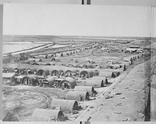
- This photograph is one in a series of views which Felice Beato made of the four Taku Forts (Harris, p. 139; Worswick, p. 138). - This photograph was made from the Great South Taku Fort looking north across the walls of the fort and the Pei (now Hai) River toward the Gulf of Chihli (now Bo Hai) (Harris, p. 143). - A copy print of this panorama under the title "Interior of South Taku Fort and Showing the Place of Landing June 25th 1859" is reproduced in Harris on pages 68-69 (cat. no. 23), and a copy print of PH1986:0901:015:002 (p. 167, fig. 23-3) under the title "Pei-Ho River and Taku Fort II" is reproduced in Harris on p. 167 (fig. 23-3).
PH1986:0901:015:001
Description:
- This photograph is one in a series of views which Felice Beato made of the four Taku Forts (Harris, p. 139; Worswick, p. 138). - This photograph was made from the Great South Taku Fort looking north across the walls of the fort and the Pei (now Hai) River toward the Gulf of Chihli (now Bo Hai) (Harris, p. 143). - A copy print of this panorama under the title "Interior of South Taku Fort and Showing the Place of Landing June 25th 1859" is reproduced in Harris on pages 68-69 (cat. no. 23), and a copy print of PH1986:0901:015:002 (p. 167, fig. 23-3) under the title "Pei-Ho River and Taku Fort II" is reproduced in Harris on p. 167 (fig. 23-3).
People:
Subject:
architecture, engineering, military, topographic
architecture, engineering, military, topographic
Date:
between 22 August and 21 September 1860
between 22 August and 21 September 1860
Title:
View showing part of the Great South Taku Fort and the Pei (now Hai) River delta, with the upper South Taku Fort and the Upper North Taku Fort in the background, Taku (now Dagu), near Tientsin (now Tianjin), China
Actions:
PH1986:0901:015:001
Description:
- This photograph is one in a series of views which Felice Beato made of the four Taku Forts (Harris, p. 139; Worswick, p. 138). - This photograph was made from the Great South Taku Fort looking north across the walls of the fort and the Pei (now Hai) River toward the Gulf of Chihli (now Bo Hai) (Harris, p. 143). - A copy print of this panorama under the title "Interior of South Taku Fort and Showing the Place of Landing June 25th 1859" is reproduced in Harris on pages 68-69 (cat. no. 23), and a copy print of PH1986:0901:015:002 (p. 167, fig. 23-3) under the title "Pei-Ho River and Taku Fort II" is reproduced in Harris on p. 167 (fig. 23-3).
View showing part of the Great South Taku Fort and the Pei (now Hai) River delta, with the upper South Taku Fort and the Upper North Taku Fort in the background, Taku (now Dagu), near Tientsin (now Tianjin), China
Actions:
PH1986:0901:015:001
Description:
- This photograph is one in a series of views which Felice Beato made of the four Taku Forts (Harris, p. 139; Worswick, p. 138). - This photograph was made from the Great South Taku Fort looking north across the walls of the fort and the Pei (now Hai) River toward the Gulf of Chihli (now Bo Hai) (Harris, p. 143). - A copy print of this panorama under the title "Interior of South Taku Fort and Showing the Place of Landing June 25th 1859" is reproduced in Harris on pages 68-69 (cat. no. 23), and a copy print of PH1986:0901:015:002 (p. 167, fig. 23-3) under the title "Pei-Ho River and Taku Fort II" is reproduced in Harris on p. 167 (fig. 23-3).
Form:
photographs
photographs
Date:
between 22 August and 21 September 1860
between 22 August and 21 September 1860
People:
Subject:
architecture, engineering, military, topographic
architecture, engineering, military, topographic
Form:
photographs
photographs
Actions:
Reference number:
PH1986:0901:015:002
Description:
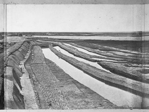
- This photograph is one in a series of views which Felice Beato made of the four Taku Forts (Harris, p. 139; Worswick, p. 138). - This photograph was made from the Great South Taku Fort looking north across the walls of the fort and the Pei (now Hai) River toward the Gulf of Chihli (now Bo Hai) (Harris, p. 143). - A copy print of this panorama under the title "Interior of South Taku Fort and Showing the Place of Landing June 25th 1859" is reproduced in Harris on pages 68-69 (cat. no. 23), and a copy print of PH1986:0901:015:002 (p. 167, fig. 23-3) under the title "Pei-Ho River and Taku Fort II" is reproduced in Harris on p. 167 (fig. 23-3).
PH1986:0901:015:002
Description:
- This photograph is one in a series of views which Felice Beato made of the four Taku Forts (Harris, p. 139; Worswick, p. 138). - This photograph was made from the Great South Taku Fort looking north across the walls of the fort and the Pei (now Hai) River toward the Gulf of Chihli (now Bo Hai) (Harris, p. 143). - A copy print of this panorama under the title "Interior of South Taku Fort and Showing the Place of Landing June 25th 1859" is reproduced in Harris on pages 68-69 (cat. no. 23), and a copy print of PH1986:0901:015:002 (p. 167, fig. 23-3) under the title "Pei-Ho River and Taku Fort II" is reproduced in Harris on p. 167 (fig. 23-3).
People:
Subject:
architecture, engineering, military, topographic
architecture, engineering, military, topographic
Date:
between 22 August and 21 September 1860
between 22 August and 21 September 1860
Title:
View showing part of the Great South Taku Fort and the Pei (now Hai) River delta, with the Lower North Taku Fort (also known as the 2nd North Fort) in the background, Taku (now Dagu), near Tientsin (now Tianjin), China
Actions:
PH1986:0901:015:002
Description:
- This photograph is one in a series of views which Felice Beato made of the four Taku Forts (Harris, p. 139; Worswick, p. 138). - This photograph was made from the Great South Taku Fort looking north across the walls of the fort and the Pei (now Hai) River toward the Gulf of Chihli (now Bo Hai) (Harris, p. 143). - A copy print of this panorama under the title "Interior of South Taku Fort and Showing the Place of Landing June 25th 1859" is reproduced in Harris on pages 68-69 (cat. no. 23), and a copy print of PH1986:0901:015:002 (p. 167, fig. 23-3) under the title "Pei-Ho River and Taku Fort II" is reproduced in Harris on p. 167 (fig. 23-3).
View showing part of the Great South Taku Fort and the Pei (now Hai) River delta, with the Lower North Taku Fort (also known as the 2nd North Fort) in the background, Taku (now Dagu), near Tientsin (now Tianjin), China
Actions:
PH1986:0901:015:002
Description:
- This photograph is one in a series of views which Felice Beato made of the four Taku Forts (Harris, p. 139; Worswick, p. 138). - This photograph was made from the Great South Taku Fort looking north across the walls of the fort and the Pei (now Hai) River toward the Gulf of Chihli (now Bo Hai) (Harris, p. 143). - A copy print of this panorama under the title "Interior of South Taku Fort and Showing the Place of Landing June 25th 1859" is reproduced in Harris on pages 68-69 (cat. no. 23), and a copy print of PH1986:0901:015:002 (p. 167, fig. 23-3) under the title "Pei-Ho River and Taku Fort II" is reproduced in Harris on p. 167 (fig. 23-3).
Form:
photographs
photographs
Date:
between 22 August and 21 September 1860
between 22 August and 21 September 1860
People:
Subject:
architecture, engineering, military, topographic
architecture, engineering, military, topographic


