


31963 Results
Form:
photographs
photographs
Title:
Couverts de l'album
Couverts de l'album
Actions:
Reference number:
ARCH284642
Description:
Les photographies de ARCH284641 étaient conservées dans ces albums.
ARCH284642
Description:
Les photographies de ARCH284641 étaient conservées dans ces albums.
People:
Date:
ca 1948
ca 1948
Title:
Couverts de l'album
Actions:
ARCH284642
Description:
Les photographies de ARCH284641 étaient conservées dans ces albums.
Couverts de l'album
Actions:
ARCH284642
Description:
Les photographies de ARCH284641 étaient conservées dans ces albums.
Form:
photographs
photographs
Date:
ca 1948
ca 1948
People:
Actions:
Reference number:
ARCH264226:003
Description:
La lettre traite de photographies de Chandigarh.
ARCH264226:003
Description:
La lettre traite de photographies de Chandigarh.
People:
Date:
8 mai 1961
8 mai 1961
Title:
Lettre de Le Corbusier à Gerd Zimmerschied relative à Chandigarh, Inde
Actions:
ARCH264226:003
Description:
La lettre traite de photographies de Chandigarh.
Lettre de Le Corbusier à Gerd Zimmerschied relative à Chandigarh, Inde
Actions:
ARCH264226:003
Description:
La lettre traite de photographies de Chandigarh.
Date:
8 mai 1961
8 mai 1961
People:
Form:
photographs
photographs
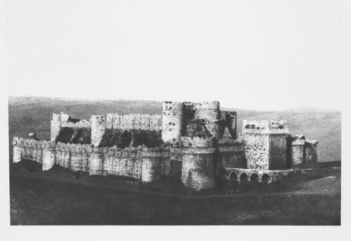
Title:
Distant view of the Krak of the Knights Castle from the southwest, Ottoman Empire (now in Syria)
Distant view of the Krak of the Knights Castle from the southwest, Ottoman Empire (now in Syria)
Actions:
Reference number:
PH1980:0048.02:017
Description:
- Suzanne K. Williamson indicates that this photograph shows western side "L" and southern side "R" of the Krak de Chevaliers Castle, Ottoman Empire (now Syria) (Oct. 1985). Further research should include verification of this information and identification of the source(s) from which it was obtained. The cardinal point indicated in the title, also provided by Williamson, is presumed to be correct.
PH1980:0048.02:017
Description:
- Suzanne K. Williamson indicates that this photograph shows western side "L" and southern side "R" of the Krak de Chevaliers Castle, Ottoman Empire (now Syria) (Oct. 1985). Further research should include verification of this information and identification of the source(s) from which it was obtained. The cardinal point indicated in the title, also provided by Williamson, is presumed to be correct.
People:
Subject:
architecture
architecture
Date:
1859-1860
1859-1860
Title:
Distant view of the Krak of the Knights Castle from the southwest, Ottoman Empire (now in Syria)
Actions:
PH1980:0048.02:017
Description:
- Suzanne K. Williamson indicates that this photograph shows western side "L" and southern side "R" of the Krak de Chevaliers Castle, Ottoman Empire (now Syria) (Oct. 1985). Further research should include verification of this information and identification of the source(s) from which it was obtained. The cardinal point indicated in the title, also provided by Williamson, is presumed to be correct.
Distant view of the Krak of the Knights Castle from the southwest, Ottoman Empire (now in Syria)
Actions:
PH1980:0048.02:017
Description:
- Suzanne K. Williamson indicates that this photograph shows western side "L" and southern side "R" of the Krak de Chevaliers Castle, Ottoman Empire (now Syria) (Oct. 1985). Further research should include verification of this information and identification of the source(s) from which it was obtained. The cardinal point indicated in the title, also provided by Williamson, is presumed to be correct.
Form:
photographs
photographs
Date:
1859-1860
1859-1860
People:
Subject:
architecture
architecture
Form:
archives
Level of archival description:
Fonds
archives
Level of archival description:
Fonds
Title:
John C. Parkin fonds
John C. Parkin fonds
Reference number:
AP018
Synopsis:
The John C. Parkin fonds documents the professional career of Toronto-based architect John C. Parkin (1922-1988) at his firms John B. Parkin Associates and Parkin Architects Planners. Most materials in this fonds record 347 architectural projects covering the years 1947-1987. John C. Parkin’s professional involvement in the arts and architecture, his firms’ activities, and his professional achievements are also recorded.
AP018
Synopsis:
The John C. Parkin fonds documents the professional career of Toronto-based architect John C. Parkin (1922-1988) at his firms John B. Parkin Associates and Parkin Architects Planners. Most materials in this fonds record 347 architectural projects covering the years 1947-1987. John C. Parkin’s professional involvement in the arts and architecture, his firms’ activities, and his professional achievements are also recorded.
People:
Date:
1929-1987
1929-1987
Title:
John C. Parkin fonds
Actions:
AP018
Synopsis:
The John C. Parkin fonds documents the professional career of Toronto-based architect John C. Parkin (1922-1988) at his firms John B. Parkin Associates and Parkin Architects Planners. Most materials in this fonds record 347 architectural projects covering the years 1947-1987. John C. Parkin’s professional involvement in the arts and architecture, his firms’ activities, and his professional achievements are also recorded.
John C. Parkin fonds
Actions:
AP018
Synopsis:
The John C. Parkin fonds documents the professional career of Toronto-based architect John C. Parkin (1922-1988) at his firms John B. Parkin Associates and Parkin Architects Planners. Most materials in this fonds record 347 architectural projects covering the years 1947-1987. John C. Parkin’s professional involvement in the arts and architecture, his firms’ activities, and his professional achievements are also recorded.
Form:
archives
Level of archival description:
Fonds
archives
Level of archival description:
Fonds
Date:
1929-1987
1929-1987
People:
Form:
photographs
photographs

Actions:
Reference number:
ARCH282756
Description:
Timbré au verso avec le nom du studio photographique et le numéro du négatif.
ARCH282756
Description:
Timbré au verso avec le nom du studio photographique et le numéro du négatif.
People:
Date:
circa 1951
circa 1951
Title:
Ernest Cormier devant la maquette d'une porte de l'immeuble de l'Assemblée générale des Nations unies, New York
Actions:
ARCH282756
Description:
Timbré au verso avec le nom du studio photographique et le numéro du négatif.
Ernest Cormier devant la maquette d'une porte de l'immeuble de l'Assemblée générale des Nations unies, New York
Actions:
ARCH282756
Description:
Timbré au verso avec le nom du studio photographique et le numéro du négatif.
Form:
photographs
photographs
Date:
circa 1951
circa 1951
People:
Form:
photographs
photographs
Reference number:
ARCH284103
Description:
Inclus des photographies de la Résidence Cormier, du Grand Séminaire de Québec, et du Campus de l'Université de Montréal. Contient les photographies numérotées P-6669 à P-6938.
ARCH284103
Description:
Inclus des photographies de la Résidence Cormier, du Grand Séminaire de Québec, et du Campus de l'Université de Montréal. Contient les photographies numérotées P-6669 à P-6938.
People:
Date:
1930s-1970s
1930s-1970s
Title:
Photographies de divers projets de Cormier et photographies de voyages
Actions:
ARCH284103
Description:
Inclus des photographies de la Résidence Cormier, du Grand Séminaire de Québec, et du Campus de l'Université de Montréal. Contient les photographies numérotées P-6669 à P-6938.
Photographies de divers projets de Cormier et photographies de voyages
Actions:
ARCH284103
Description:
Inclus des photographies de la Résidence Cormier, du Grand Séminaire de Québec, et du Campus de l'Université de Montréal. Contient les photographies numérotées P-6669 à P-6938.
Form:
photographs
photographs
Date:
1930s-1970s
1930s-1970s
People:
Form:
photographs
photographs
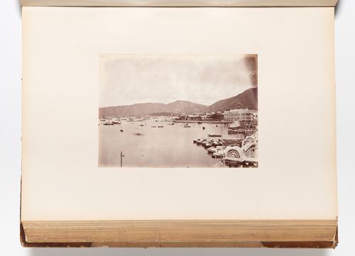
Actions:
Reference number:
PH1981:0620:057
Description:
- A hand-written table of contents accompanies album PH1981:0620:001-081. - This photograph was taken from the roof of a building on the Praya. The Cricket Ground is visible from centre to centre right, the City Hall is visible at centre right. Wan Chai district is visible in the distance at centre and East Point is visible in the distance at centre left.
PH1981:0620:057
Description:
- A hand-written table of contents accompanies album PH1981:0620:001-081. - This photograph was taken from the roof of a building on the Praya. The Cricket Ground is visible from centre to centre right, the City Hall is visible at centre right. Wan Chai district is visible in the distance at centre and East Point is visible in the distance at centre left.
People:
Subject:
architecture, topographic
architecture, topographic
Date:
1867 or after
1867 or after
Title:
View of the harbour showing the City Hall and the Cricket Ground in the middle distance and Wan Chai district and East Point in the far distance, Hong Kong (now Hong Kong, China)
Actions:
PH1981:0620:057
Description:
- A hand-written table of contents accompanies album PH1981:0620:001-081. - This photograph was taken from the roof of a building on the Praya. The Cricket Ground is visible from centre to centre right, the City Hall is visible at centre right. Wan Chai district is visible in the distance at centre and East Point is visible in the distance at centre left.
View of the harbour showing the City Hall and the Cricket Ground in the middle distance and Wan Chai district and East Point in the far distance, Hong Kong (now Hong Kong, China)
Actions:
PH1981:0620:057
Description:
- A hand-written table of contents accompanies album PH1981:0620:001-081. - This photograph was taken from the roof of a building on the Praya. The Cricket Ground is visible from centre to centre right, the City Hall is visible at centre right. Wan Chai district is visible in the distance at centre and East Point is visible in the distance at centre left.
Form:
photographs
photographs
Date:
1867 or after
1867 or after
People:
Subject:
architecture, topographic
architecture, topographic
Form:
drawings, textual records, born digital, photographs
drawings, textual records, born digital, photographs
Actions:
Reference number:
AP181.S1.019
Description:
Original directory name: "25_TRIAS-Aussenbrücke". File content shows the design and construction planning for a pedestrian bridge connecting BMW Welt to the BMW Museum. Records include plans, drawings, research material, presentations, approval planning, building specification, list of plans, final handover of the arch bridge, etc. The bulk of records are CAD drawings and 3D models of the design development and planning. The drawings are organized by type of plan: site plan, sections, axonometric views, etc. As for 3D models, they are organized mostly by file format, and then by date. The "3D" sub-directory also contains more than 1500 screenshots saved as JPEG. Additional records include site photographs, digitized sketches, visual research material, presentations of the concept, bridge structure technical descriptions, 2D and 3D technical drawings (in PDF, CAD, JPG, and Illustrator formats), renderings, project planning charts, and plan lists. Most common file formats: JPEG File Interchange Format, AutoCAD Drawing, 3DM, Exchangeable Image File Format (Compressed), Maya Binary File Format
AP181.S1.019
Description:
Original directory name: "25_TRIAS-Aussenbrücke". File content shows the design and construction planning for a pedestrian bridge connecting BMW Welt to the BMW Museum. Records include plans, drawings, research material, presentations, approval planning, building specification, list of plans, final handover of the arch bridge, etc. The bulk of records are CAD drawings and 3D models of the design development and planning. The drawings are organized by type of plan: site plan, sections, axonometric views, etc. As for 3D models, they are organized mostly by file format, and then by date. The "3D" sub-directory also contains more than 1500 screenshots saved as JPEG. Additional records include site photographs, digitized sketches, visual research material, presentations of the concept, bridge structure technical descriptions, 2D and 3D technical drawings (in PDF, CAD, JPG, and Illustrator formats), renderings, project planning charts, and plan lists. Most common file formats: JPEG File Interchange Format, AutoCAD Drawing, 3DM, Exchangeable Image File Format (Compressed), Maya Binary File Format
People:
Date:
2002-2007
2002-2007
Title:
Design and construction planning of bridge to BMW Museum, BMW Welt, Munich
Actions:
AP181.S1.019
Description:
Original directory name: "25_TRIAS-Aussenbrücke". File content shows the design and construction planning for a pedestrian bridge connecting BMW Welt to the BMW Museum. Records include plans, drawings, research material, presentations, approval planning, building specification, list of plans, final handover of the arch bridge, etc. The bulk of records are CAD drawings and 3D models of the design development and planning. The drawings are organized by type of plan: site plan, sections, axonometric views, etc. As for 3D models, they are organized mostly by file format, and then by date. The "3D" sub-directory also contains more than 1500 screenshots saved as JPEG. Additional records include site photographs, digitized sketches, visual research material, presentations of the concept, bridge structure technical descriptions, 2D and 3D technical drawings (in PDF, CAD, JPG, and Illustrator formats), renderings, project planning charts, and plan lists. Most common file formats: JPEG File Interchange Format, AutoCAD Drawing, 3DM, Exchangeable Image File Format (Compressed), Maya Binary File Format
Design and construction planning of bridge to BMW Museum, BMW Welt, Munich
Actions:
AP181.S1.019
Description:
Original directory name: "25_TRIAS-Aussenbrücke". File content shows the design and construction planning for a pedestrian bridge connecting BMW Welt to the BMW Museum. Records include plans, drawings, research material, presentations, approval planning, building specification, list of plans, final handover of the arch bridge, etc. The bulk of records are CAD drawings and 3D models of the design development and planning. The drawings are organized by type of plan: site plan, sections, axonometric views, etc. As for 3D models, they are organized mostly by file format, and then by date. The "3D" sub-directory also contains more than 1500 screenshots saved as JPEG. Additional records include site photographs, digitized sketches, visual research material, presentations of the concept, bridge structure technical descriptions, 2D and 3D technical drawings (in PDF, CAD, JPG, and Illustrator formats), renderings, project planning charts, and plan lists. Most common file formats: JPEG File Interchange Format, AutoCAD Drawing, 3DM, Exchangeable Image File Format (Compressed), Maya Binary File Format
Form:
drawings, textual records, born digital, photographs
drawings, textual records, born digital, photographs
Date:
2002-2007
2002-2007
People:
Level of archival description:
Project
Project
Actions:
Reference number:
AP018.S1.1972.PR18
Description:
This project series documents the design and construction of a library and an addition to city hall in Fredericton, New Brunswick from 1972-1975. The office identified the project number as 7226. This project consisted of two distinct parts; a public library constructed at the corners of Campbell and Carleton Streets, and an addition to city hall whose original building was constructed at the corners of Queen and York Streets around 1875. These two buildings were located two blocks from one another, but a master plan for the project shows that the separating streets would be removed in favour of a pedestrian friendly landscape. Both buildings were located next to the St. John River. For this project, Parkin Architects Planners partnered with architectural firm Graham Napier Associates to form the joint venture referred to as Graham Parkin Architects Engineers Planners. The brick-clad addition to city hall nearly doubled the square footage of the ground and first floors. The original city hall was four levels and the addition was two, with a mechanical penthouse on top. The new areas included departmental offices such as planning, engineering and sewage, a drafting room, conference room, and reception, among others. The library consisted of a two-storey, brick-clad building that was approximately 24,000 square feet in size with a 16 car parking lot. The ground floor included reception and exhibit areas, stacks, administration offices, bookmobiles, and staff lockers, while the second level had stacks and reading areas, audiovisual areas and a staff work room and break room. The library also had a mechanical penthouse on top. The project is recorded through drawings, including mounted presentation boards, photographic materials and textual records dating from 1972-1978. The drawings consist of original sketches, plans, sections, elevations and details of both city hall and the library, and some drawings used for construction. There are also drawings of the original city hall, first drafted around 1875. The photographs show existing buildings and the construction progress of the project. The textual records consist of correspondence, conference reports, interoffice letters, specifications, consultancy documentation, a soil investigation, research and drawing transmittal records. File AP018.S1.1972.PR18.020 contains an index to the textual materials, which was created by the office.
AP018.S1.1972.PR18
Description:
This project series documents the design and construction of a library and an addition to city hall in Fredericton, New Brunswick from 1972-1975. The office identified the project number as 7226. This project consisted of two distinct parts; a public library constructed at the corners of Campbell and Carleton Streets, and an addition to city hall whose original building was constructed at the corners of Queen and York Streets around 1875. These two buildings were located two blocks from one another, but a master plan for the project shows that the separating streets would be removed in favour of a pedestrian friendly landscape. Both buildings were located next to the St. John River. For this project, Parkin Architects Planners partnered with architectural firm Graham Napier Associates to form the joint venture referred to as Graham Parkin Architects Engineers Planners. The brick-clad addition to city hall nearly doubled the square footage of the ground and first floors. The original city hall was four levels and the addition was two, with a mechanical penthouse on top. The new areas included departmental offices such as planning, engineering and sewage, a drafting room, conference room, and reception, among others. The library consisted of a two-storey, brick-clad building that was approximately 24,000 square feet in size with a 16 car parking lot. The ground floor included reception and exhibit areas, stacks, administration offices, bookmobiles, and staff lockers, while the second level had stacks and reading areas, audiovisual areas and a staff work room and break room. The library also had a mechanical penthouse on top. The project is recorded through drawings, including mounted presentation boards, photographic materials and textual records dating from 1972-1978. The drawings consist of original sketches, plans, sections, elevations and details of both city hall and the library, and some drawings used for construction. There are also drawings of the original city hall, first drafted around 1875. The photographs show existing buildings and the construction progress of the project. The textual records consist of correspondence, conference reports, interoffice letters, specifications, consultancy documentation, a soil investigation, research and drawing transmittal records. File AP018.S1.1972.PR18.020 contains an index to the textual materials, which was created by the office.
People:
Date:
circa 1972-1978
circa 1972-1978
Title:
City Hall and Library Facilities, Fredericton, New Brunswick (1972-1975)
Actions:
AP018.S1.1972.PR18
Description:
This project series documents the design and construction of a library and an addition to city hall in Fredericton, New Brunswick from 1972-1975. The office identified the project number as 7226. This project consisted of two distinct parts; a public library constructed at the corners of Campbell and Carleton Streets, and an addition to city hall whose original building was constructed at the corners of Queen and York Streets around 1875. These two buildings were located two blocks from one another, but a master plan for the project shows that the separating streets would be removed in favour of a pedestrian friendly landscape. Both buildings were located next to the St. John River. For this project, Parkin Architects Planners partnered with architectural firm Graham Napier Associates to form the joint venture referred to as Graham Parkin Architects Engineers Planners. The brick-clad addition to city hall nearly doubled the square footage of the ground and first floors. The original city hall was four levels and the addition was two, with a mechanical penthouse on top. The new areas included departmental offices such as planning, engineering and sewage, a drafting room, conference room, and reception, among others. The library consisted of a two-storey, brick-clad building that was approximately 24,000 square feet in size with a 16 car parking lot. The ground floor included reception and exhibit areas, stacks, administration offices, bookmobiles, and staff lockers, while the second level had stacks and reading areas, audiovisual areas and a staff work room and break room. The library also had a mechanical penthouse on top. The project is recorded through drawings, including mounted presentation boards, photographic materials and textual records dating from 1972-1978. The drawings consist of original sketches, plans, sections, elevations and details of both city hall and the library, and some drawings used for construction. There are also drawings of the original city hall, first drafted around 1875. The photographs show existing buildings and the construction progress of the project. The textual records consist of correspondence, conference reports, interoffice letters, specifications, consultancy documentation, a soil investigation, research and drawing transmittal records. File AP018.S1.1972.PR18.020 contains an index to the textual materials, which was created by the office.
City Hall and Library Facilities, Fredericton, New Brunswick (1972-1975)
Actions:
AP018.S1.1972.PR18
Description:
This project series documents the design and construction of a library and an addition to city hall in Fredericton, New Brunswick from 1972-1975. The office identified the project number as 7226. This project consisted of two distinct parts; a public library constructed at the corners of Campbell and Carleton Streets, and an addition to city hall whose original building was constructed at the corners of Queen and York Streets around 1875. These two buildings were located two blocks from one another, but a master plan for the project shows that the separating streets would be removed in favour of a pedestrian friendly landscape. Both buildings were located next to the St. John River. For this project, Parkin Architects Planners partnered with architectural firm Graham Napier Associates to form the joint venture referred to as Graham Parkin Architects Engineers Planners. The brick-clad addition to city hall nearly doubled the square footage of the ground and first floors. The original city hall was four levels and the addition was two, with a mechanical penthouse on top. The new areas included departmental offices such as planning, engineering and sewage, a drafting room, conference room, and reception, among others. The library consisted of a two-storey, brick-clad building that was approximately 24,000 square feet in size with a 16 car parking lot. The ground floor included reception and exhibit areas, stacks, administration offices, bookmobiles, and staff lockers, while the second level had stacks and reading areas, audiovisual areas and a staff work room and break room. The library also had a mechanical penthouse on top. The project is recorded through drawings, including mounted presentation boards, photographic materials and textual records dating from 1972-1978. The drawings consist of original sketches, plans, sections, elevations and details of both city hall and the library, and some drawings used for construction. There are also drawings of the original city hall, first drafted around 1875. The photographs show existing buildings and the construction progress of the project. The textual records consist of correspondence, conference reports, interoffice letters, specifications, consultancy documentation, a soil investigation, research and drawing transmittal records. File AP018.S1.1972.PR18.020 contains an index to the textual materials, which was created by the office.
Level of archival description:
Project
Project
Date:
circa 1972-1978
circa 1972-1978
People:
Form:
drawings
drawings
Actions:
Reference number:
PH1979:0603.02:015
Description:
- The pumps shown in this photograph consisted of a long square wooden tube into which a looped chain is fitted. Attached to the chain are wooden diaphragms which are spaced six inches apart and are guided by rods above the tube. The chain is made to revolve by human foot-power, bringing water to the upper level.
PH1979:0603.02:015
Description:
- The pumps shown in this photograph consisted of a long square wooden tube into which a looped chain is fitted. Attached to the chain are wooden diaphragms which are spaced six inches apart and are guided by rods above the tube. The chain is made to revolve by human foot-power, bringing water to the upper level.
People:
Subject:
engineering, topographic
engineering, topographic
Date:
published 1873
published 1873
Title:
View of chain pumps used for irrigation near Swatow (now Shantou), Kwangtung Province (now Guangdong Sheng), China
Actions:
PH1979:0603.02:015
Description:
- The pumps shown in this photograph consisted of a long square wooden tube into which a looped chain is fitted. Attached to the chain are wooden diaphragms which are spaced six inches apart and are guided by rods above the tube. The chain is made to revolve by human foot-power, bringing water to the upper level.
View of chain pumps used for irrigation near Swatow (now Shantou), Kwangtung Province (now Guangdong Sheng), China
Actions:
PH1979:0603.02:015
Description:
- The pumps shown in this photograph consisted of a long square wooden tube into which a looped chain is fitted. Attached to the chain are wooden diaphragms which are spaced six inches apart and are guided by rods above the tube. The chain is made to revolve by human foot-power, bringing water to the upper level.
Form:
drawings
drawings
Date:
published 1873
published 1873
People:
Subject:
engineering, topographic
engineering, topographic


