109 Résultats
Classification:
livres
livres
Actions:
Prix:
$46.95
(disponible sur commande)
Résumé:
Des pays qui n'existent pas vraiment, la seule ville presque entièrement souterraine au monde, une chambre d'hôtel britannique devenue yougoslave l'espace d'une journée, une îleespagnole la moitié de l'année et française le reste du temps, une ville qui se résume à un gratte-ciel de 14 étages, la seule et unique voie ferrée installée à l'extérieur de son pays... Le monde(...)
Titre:
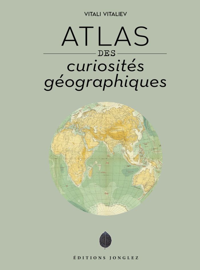
Atlas des curiosités géograhiques
Actions:
Prix:
$46.95
(disponible sur commande)
Résumé:
Des pays qui n'existent pas vraiment, la seule ville presque entièrement souterraine au monde, une chambre d'hôtel britannique devenue yougoslave l'espace d'une journée, une îleespagnole la moitié de l'année et française le reste du temps, une ville qui se résume à un gratte-ciel de 14 étages, la seule et unique voie ferrée installée à l'extérieur de son pays... Le monde regorge de curiosités géographiques qui sont souvent à l'origine de tensions diplomatiques ou militaires. Bien souvent méconnues, elles n'en représentent pas moins autant d'étincelles susceptibles de mettre le feu aux poudres sur la scène internationale.
Classification:
livres
livres
Publication:
octobre 2022
octobre 2022
Classification:
livres
livres
Actions:
Prix:
$67.95
(disponible sur commande)
Résumé:
Parcourant le monde à travers de magnifiques cartes de toutes provenances et de toutes époques, l’écrivaine de voyage Francisca Mattéoli nous offre une aventure géographique étonnante en une vingtaine de récits sur les lieux qui l’inspirent ou l’ont marquée lors de ses voyages.
Titre:
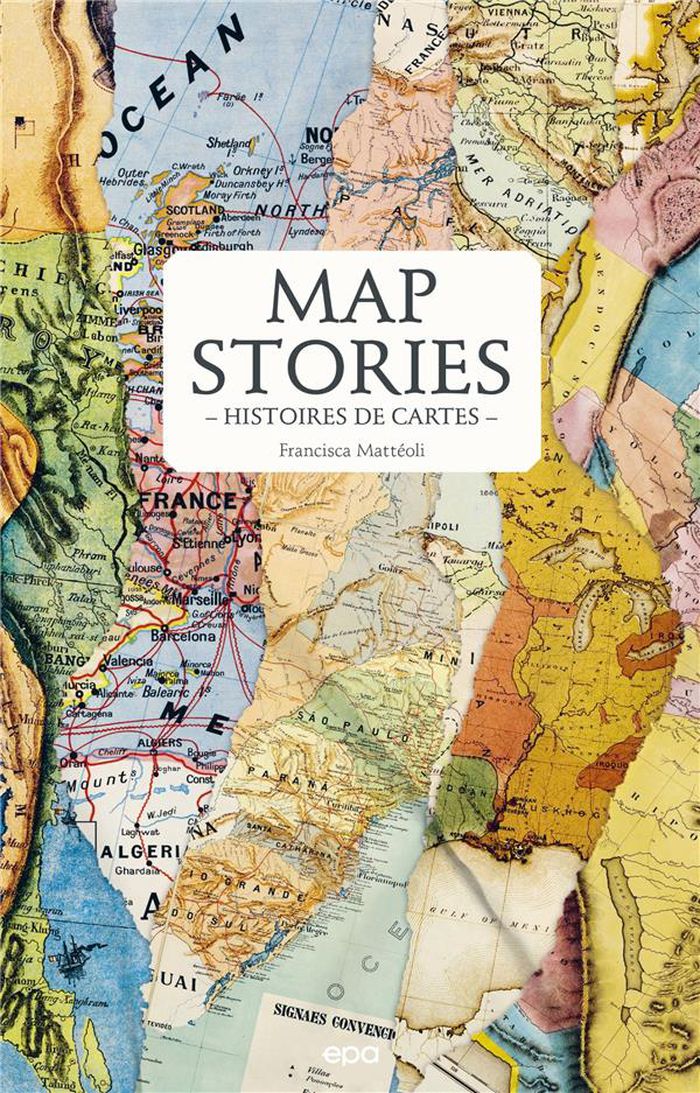
Map stories / Histoires de cartes
Actions:
Prix:
$67.95
(disponible sur commande)
Résumé:
Parcourant le monde à travers de magnifiques cartes de toutes provenances et de toutes époques, l’écrivaine de voyage Francisca Mattéoli nous offre une aventure géographique étonnante en une vingtaine de récits sur les lieux qui l’inspirent ou l’ont marquée lors de ses voyages.
Classification:
livres
livres
Publication:
février 2023
février 2023
Classification:
livres
livres
Titre:
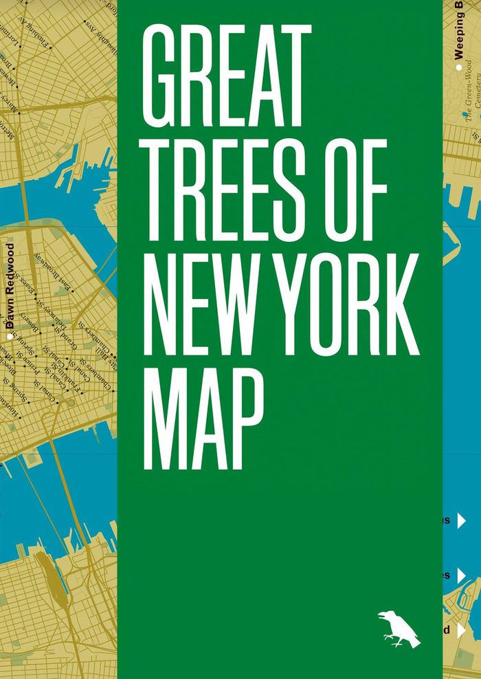
Great trees of New York map
Great trees of New York map
Actions:
Prix:
$18.95
(disponible en magasin)
Résumé:
This is a guide to 50 of the oldest, rarest, strangest, and most historic trees across New York City’s five boroughs, from the 350-year-old “Alley Pond Giant” in Queens to the wizened Camperdown elm in Prospect Park. This two-sided companion includes a map, an introduction and descriptions by Allison C. Meier, and original photography by Colin Montgomery.
Publication:
mai 2021
mai 2021
Titre:
Great trees of New York map
Actions:
Prix:
$18.95
(disponible en magasin)
Résumé:
This is a guide to 50 of the oldest, rarest, strangest, and most historic trees across New York City’s five boroughs, from the 350-year-old “Alley Pond Giant” in Queens to the wizened Camperdown elm in Prospect Park. This two-sided companion includes a map, an introduction and descriptions by Allison C. Meier, and original photography by Colin Montgomery.
Classification:
livres
livres
Publication:
mai 2021
mai 2021
Classification:
livres
livres
Titre:
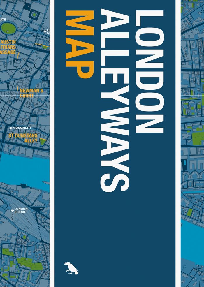
London alleyways map
London alleyways map
Actions:
Prix:
$18.95
(disponible sur commande)
Résumé:
London's alleyways have a habit of leading to unexpected places. They act as the city’s library: echoing the routes of trade, lost rivers, burial roads, disputed boundaries, tracks of animals and people. They hold the stories of a city that otherwise can no longer be seen. This map is your entry point to this story.
Publication:
octobre 2022
octobre 2022
Titre:
London alleyways map
Actions:
Prix:
$18.95
(disponible sur commande)
Résumé:
London's alleyways have a habit of leading to unexpected places. They act as the city’s library: echoing the routes of trade, lost rivers, burial roads, disputed boundaries, tracks of animals and people. They hold the stories of a city that otherwise can no longer be seen. This map is your entry point to this story.
Classification:
livres
livres
Publication:
octobre 2022
octobre 2022
Classification:
livres
livres
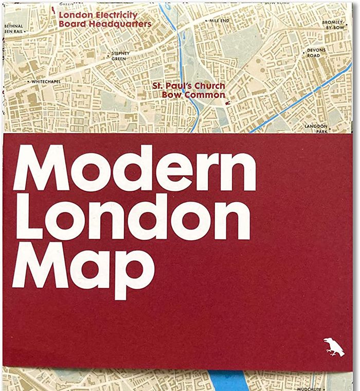
Titre:
Modern London map
Modern London map
Actions:
Prix:
$14.00
(disponible sur commande)
Résumé:
Explore extraordinary examples of Modern architecture built across London between 1930 and 1960 with this two-sided map. Featuring over fifty buildings, from social housing to churches and the Festival Hall, this guide includes original photography by Nigel Green and building details and an introduction by Robin Wilson.
Titre:
Modern London map
Actions:
Prix:
$14.00
(disponible sur commande)
Résumé:
Explore extraordinary examples of Modern architecture built across London between 1930 and 1960 with this two-sided map. Featuring over fifty buildings, from social housing to churches and the Festival Hall, this guide includes original photography by Nigel Green and building details and an introduction by Robin Wilson.
Classification:
livres
livres
Publication:
octobre 2022
octobre 2022
Classification:
livres
livres
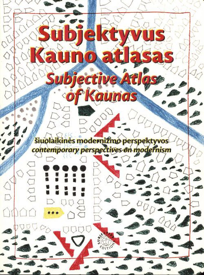
Titre:
Subjective atlas of Kaunas
Subjective atlas of Kaunas
Actions:
Prix:
$48.00
(disponible sur commande)
Résumé:
Between 1919 and 1940, Kaunas served as Lithuania’s temporary capital, triggering a massive boom in construction that greatly increased its urban area. For this instalment of the Subjective Atlas series, a group of almost 40 creative residents mapped the contemporary identity of Kaunas through their personal interests, experiences, and domesticity, visualising the(...)
Titre:
Subjective atlas of Kaunas
Actions:
Prix:
$48.00
(disponible sur commande)
Résumé:
Between 1919 and 1940, Kaunas served as Lithuania’s temporary capital, triggering a massive boom in construction that greatly increased its urban area. For this instalment of the Subjective Atlas series, a group of almost 40 creative residents mapped the contemporary identity of Kaunas through their personal interests, experiences, and domesticity, visualising the heritage and history of Lithuania’s second-largest city. The book highlights a surprising collection of urban, natural, and everyday spaces and artefacts, inviting readers to reflect on how this material and immaterial modernist heritage is perceived or observed, appreciated or disliked, ignored or associated with.
Classification:
livres
livres
Publication:
mars 2022
mars 2022
Classification:
livres
livres
Actions:
Prix:
$47.95
(disponible sur commande)
Résumé:
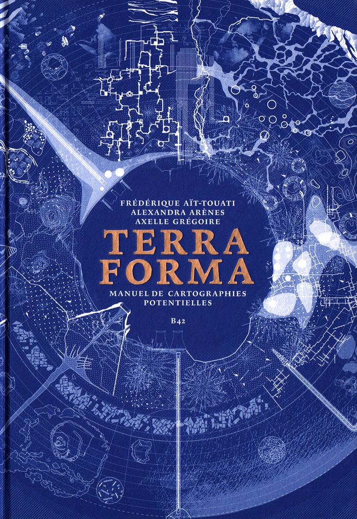
Ce livre raconte l’exploration d’une terre inconnue, la nôtre. À la suite des voyageurs de la Renaissance partis cartographier les terra incognita du Nouveau Monde, « Terra Forma » propose, cinq siècles plus tard, de découvrir une autre Terre, ou plutôt de redécouvrir autrement celle que nous croyons si bien connaître en partant du constat que si les transformations(...)
$47.95
(disponible sur commande)
Résumé:
Ce livre raconte l’exploration d’une terre inconnue, la nôtre. À la suite des voyageurs de la Renaissance partis cartographier les terra incognita du Nouveau Monde, « Terra Forma » propose, cinq siècles plus tard, de découvrir une autre Terre, ou plutôt de redécouvrir autrement celle que nous croyons si bien connaître en partant du constat que si les transformations(...)
Titre:
Terra forma : manuel de cartographies potentielles
Actions:
Prix:
$47.95
(disponible sur commande)
Résumé:
Ce livre raconte l’exploration d’une terre inconnue, la nôtre. À la suite des voyageurs de la Renaissance partis cartographier les terra incognita du Nouveau Monde, « Terra Forma » propose, cinq siècles plus tard, de découvrir une autre Terre, ou plutôt de redécouvrir autrement celle que nous croyons si bien connaître en partant du constat que si les transformations récentes des conditions d’habitabilité du monde sont si difficiles à percevoir, c’est parce que les représentations disponibles sont trop abstraites, lointaines, et dans une certaine mesure trop stables. En proposant une extension du vocabulaire cartographique, ce livre est un manifeste pour l’imagination géographique, et, ce faisant, politique. Si certains des phénomènes auxquels nous assistons (érosion des sols, épuisement des ressources, accélération des espaces-temps urbains, intensification des zones polluées) nous échappent par leur échelle, leur durée, leur ampleur, c’est par le développement de nos techniques de représentation que l’on peut espérer mieux les comprendre. En mettant en « cartes » certaines propositions des sciences du Système-Terre et de la pensée écologique contemporaine, « Terra Forma » permet de mieux saisir leur portée politique.
Classification:
livres
livres
Publication:
mai 2019
mai 2019
Classification:
livres
livres
Prix:
$44.95
(disponible sur commande)
Résumé:
Many people have a love of maps. But what lies behind the process of map-making? How have cartographers through the centuries developed their craft and established a language of maps which helps them to better represent our world and help users to understand it? This book tells the story of how widely accepted mapping conventions originated and evolved—from map(...)
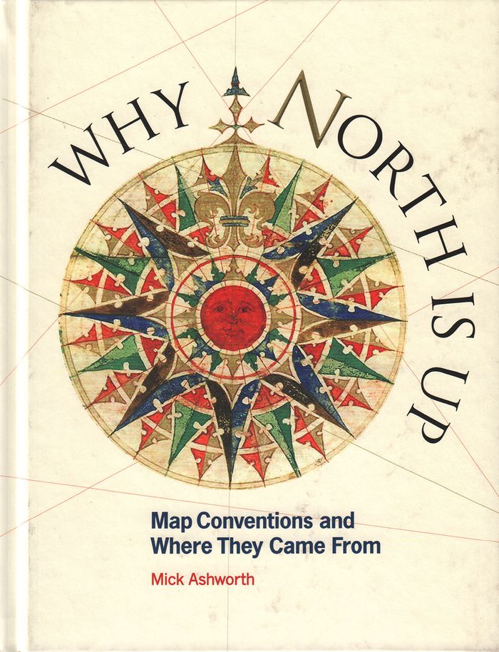
Titre:
Why North is up: map conventions and where they came from
Actions:
Prix:
$44.95
(disponible sur commande)
Résumé:
Many people have a love of maps. But what lies behind the process of map-making? How have cartographers through the centuries developed their craft and established a language of maps which helps them to better represent our world and help users to understand it? This book tells the story of how widely accepted mapping conventions originated and evolved—from map orientation, projections, typography, and scale, to the use of color, symbols, ways of representing relief, and the treatment of boundaries and place names. It charts the fascinating story of how conventions have changed in response to new technologies and ever-changing mapping requirements, how symbols can be a matter of life or death, why universal acceptance of conventions can be difficult to achieve, and how new mapping conventions are developing to meet the needs of modern cartography. "Why North is Up" offers a guide to the sometimes hidden techniques of map-making through the centuries.
Classification:
livres
livres
Publication:
décembre 2019
décembre 2019
Classification:
livres
livres
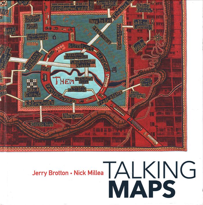
Titre:
Talking maps
Talking maps
Actions:
Prix:
$74.95
(disponible sur commande)
Résumé:
Every map tells a story. Some provide a narrative for travelers, explorers, and surveyors or offer a visual account of changes to people’s lives and surroundings, while others tell imaginary tales, transporting us to fictional worlds created by writers and artists. In turn, maps generate more stories, taking users on new journeys in search of knowledge and adventure. By(...)
Publication:
novembre 2019
novembre 2019
Titre:
Talking maps
Actions:
Prix:
$74.95
(disponible sur commande)
Résumé:
Every map tells a story. Some provide a narrative for travelers, explorers, and surveyors or offer a visual account of changes to people’s lives and surroundings, while others tell imaginary tales, transporting us to fictional worlds created by writers and artists. In turn, maps generate more stories, taking users on new journeys in search of knowledge and adventure. By telling the stories behind the artifacts and those generated by them, "Talking Maps " reveals how each map is not just a tool for navigation but also a worldly proposal that helps us to understand who we are by describing where we are.
Classification:
livres
livres
Publication:
novembre 2019
novembre 2019
Classification:
livres
livres
Prix:
$70.00
(disponible sur commande)
Résumé:
This is the first book to catalog comparative maps and tableaux that visualize the heights and lengths of the world's mountains and rivers. Produced predominantly in the nineteenth century, these maps emerged out of the tide of exploration and scientific developments in measuring techniques. Beginning with the work of explorer Alexander von Humboldt, these historic(...)
Publication:
septembre 2019
septembre 2019
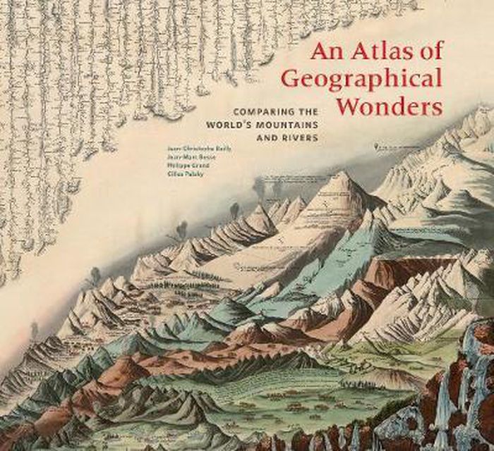
Titre:
An atlas of geographical wonders: from mountaintops to riverbeds
Actions:
Prix:
$70.00
(disponible sur commande)
Résumé:
This is the first book to catalog comparative maps and tableaux that visualize the heights and lengths of the world's mountains and rivers. Produced predominantly in the nineteenth century, these maps emerged out of the tide of exploration and scientific developments in measuring techniques. Beginning with the work of explorer Alexander von Humboldt, these historic drawings reveal a world of artistic and imaginative difference. Many of them give way—and with visible joy—to the power of fantasy in a mesmerizing array of realistic and imaginary forms. Most of the maps are from the David Rumsey Historical Map Collection at Stanford University.
Classification:
livres
livres
Publication:
septembre 2019
septembre 2019