1500 Résultats
Classification:
dessins
dessins
Numéro de référence:
AP018.S1.1976.PR23.033
AP018.S1.1976.PR23.033
Personnes et institutions:
Date:
circa 1976
circa 1976
Classification:
dessins
dessins
Date:
circa 1976
circa 1976
Personnes et institutions:
Classification:
dessins
dessins
Numéro de référence:
AP018.S1.1971.PR07.032
AP018.S1.1971.PR07.032
Personnes et institutions:
Date:
1972
1972
Classification:
dessins
dessins
Date:
1972
1972
Personnes et institutions:
Classification:
documents textuels
documents textuels
Numéro de référence:
PHCON2002:0016:001:037.2
PHCON2002:0016:001:037.2
Personnes et institutions:
Date:
1970-1978
1970-1978
Classification:
documents textuels
documents textuels
Date:
1970-1978
1970-1978
Personnes et institutions:
Classification:
documents textuels
documents textuels
Numéro de référence:
ARCH278311
Description:
File's title: A&H 1988, B.2: "La Piel inútil" [...] "En los limites" [...].
ARCH278311
Description:
File's title: A&H 1988, B.2: "La Piel inútil" [...] "En los limites" [...].
Personnes et institutions:
Date:
1988-1989
1988-1989
Titre:
Writings by Abalos & Herreros
Actions:
ARCH278311
Description:
File's title: A&H 1988, B.2: "La Piel inútil" [...] "En los limites" [...].
Writings by Abalos & Herreros
Actions:
ARCH278311
Description:
File's title: A&H 1988, B.2: "La Piel inútil" [...] "En los limites" [...].
Classification:
documents textuels
documents textuels
Date:
1988-1989
1988-1989
Personnes et institutions:
Classification:
événements
événements
Description:
Comment les optiques computationnelles opèrent-t-elles dans et à travers l’environnement bâti? Comment sont-elles devenues si omniprésentes et considérées comme allant de soi, répondant aux désirs des centres dexécution et à la lisibilité dont l’informatique a besoin? Quelles logiques, quels imaginaires et quels cadres informatiques se situent en dehors de leurs modes(...)
Comment les optiques computationnelles opèrent-t-elles dans et à travers l’environnement bâti? Comment sont-elles devenues si omniprésentes et considérées comme allant de soi, répondant aux désirs des centres dexécution et à la lisibilité dont l’informatique a besoin? Quelles logiques, quels imaginaires et quels cadres informatiques se situent en dehors de leurs modes(...)
Localisation:
Maison Shaughnessy, CCA Mot(s)-clé(s):
Outils d'aujourd'hui, optiques computationnelles
Maison Shaughnessy, CCA Mot(s)-clé(s):
Outils d'aujourd'hui, optiques computationnelles
Date:
17 juillet 2025, 18h
17 juillet 2025, 18h
Titre:
Outils d’aujourd’hui : Défier les envies computationnelles
Actions:
Description:
Comment les optiques computationnelles opèrent-t-elles dans et à travers l’environnement bâti? Comment sont-elles devenues si omniprésentes et considérées comme allant de soi, répondant aux désirs des centres dexécution et à la lisibilité dont l’informatique a besoin? Quelles logiques, quels imaginaires et quels cadres informatiques se situent en dehors de leurs modes(...)
Classification:
événements
événements
Date:
17 juillet 2025
18h
17 juillet 2025
18h
Localisation:
Maison Shaughnessy, CCA Mot(s)-clé(s):
Outils d'aujourd'hui, optiques computationnelles
Maison Shaughnessy, CCA Mot(s)-clé(s):
Outils d'aujourd'hui, optiques computationnelles
Niveau de description archivistique:
Projet
Projet
Numéro de référence:
AP027.S1.D10
Description:
Proposed plan for the future of the Village of Woodbridge examined in respect to the development of Metropolitan Toronto. Physical growth of village is projected against limits of existing facilities. The report is a response to an earlier study by the Metropolitan Toronto Planning Board which examined whether or not Woodbridge should be annexed.
Personnes et institutions:
Sujet:
urbanisme
urbanisme
Date:
1960
1960
Titre:
Woodbridge, Ontario
Actions:
AP027.S1.D10
Description:
Proposed plan for the future of the Village of Woodbridge examined in respect to the development of Metropolitan Toronto. Physical growth of village is projected against limits of existing facilities. The report is a response to an earlier study by the Metropolitan Toronto Planning Board which examined whether or not Woodbridge should be annexed.
Niveau de description archivistique:
File 10
File 10
Date:
1960
1960
Personnes et institutions:
Sujet:
urbanisme
urbanisme
Niveau de description archivistique:
Projet
Projet
Numéro de référence:
AP066.S2.D28
Description:
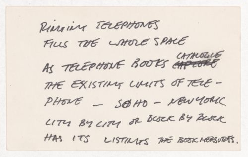
Le dossier documente les études préliminaires pour un projet de 130 logements comportant des coopératives d'habitation et des condominiums au Site Angus, situé sur l'avenue Mont-Royal, à Montréal, Québec. Description du projet par l'architecte: "Situé aux limites nord du site Angus, le projet se pose à la fois comme clé de voûte du plan d'ensemble de l'Avenue du Mont-Royal et comme charnière permettant de désenclaver ce secteur vers le Boulevard St-Joseph au nord." Texte non signé et non paginé, probablement écrit par Rousseau, Angus 19-38: concept architectural. Le dossier contient des reprographies, des dessins, des documents textuels et des cahiers.
AP066.S2.D28
Description:
Le dossier documente les études préliminaires pour un projet de 130 logements comportant des coopératives d'habitation et des condominiums au Site Angus, situé sur l'avenue Mont-Royal, à Montréal, Québec. Description du projet par l'architecte: "Situé aux limites nord du site Angus, le projet se pose à la fois comme clé de voûte du plan d'ensemble de l'Avenue du Mont-Royal et comme charnière permettant de désenclaver ce secteur vers le Boulevard St-Joseph au nord." Texte non signé et non paginé, probablement écrit par Rousseau, Angus 19-38: concept architectural. Le dossier contient des reprographies, des dessins, des documents textuels et des cahiers.
Personnes et institutions:
Date:
1991
1991
Titre:
Projet Site Angus
Actions:
AP066.S2.D28
Description:
Le dossier documente les études préliminaires pour un projet de 130 logements comportant des coopératives d'habitation et des condominiums au Site Angus, situé sur l'avenue Mont-Royal, à Montréal, Québec. Description du projet par l'architecte: "Situé aux limites nord du site Angus, le projet se pose à la fois comme clé de voûte du plan d'ensemble de l'Avenue du Mont-Royal et comme charnière permettant de désenclaver ce secteur vers le Boulevard St-Joseph au nord." Texte non signé et non paginé, probablement écrit par Rousseau, Angus 19-38: concept architectural. Le dossier contient des reprographies, des dessins, des documents textuels et des cahiers.
Niveau de description archivistique:
Projet
Projet
Date:
1991
1991
Personnes et institutions:
Niveau de description archivistique:
Projet
Projet
Numéro de référence:
AP164.S1.1987.D1
Description:
This project series documents the infrastructure for the reorganization of the Nueva Montaña Quijano (N.M.Q.) in Santander, Spain. The office identified this project as number 45. As described by the architect, the project is “to pursue an idea for a complete city that is independent of and complementary to the existing one, while solving the matter of Santander's connection to the rest of the region and respecting building limits set by laws in force, quantity-wise, as well as height restrictions imposed by airport authorities." (ARCH270753) Documenting the project are conceptual, design development, presentation and working drawings, project descriptions and other textual documentation, models and cartographic materials.
Personnes et institutions:
Date:
1987-1990
1987-1990
Titre:
Ordenación de Nueva Montaña Quijano en Santander, Spain (1987)
Actions:
AP164.S1.1987.D1
Description:
This project series documents the infrastructure for the reorganization of the Nueva Montaña Quijano (N.M.Q.) in Santander, Spain. The office identified this project as number 45. As described by the architect, the project is “to pursue an idea for a complete city that is independent of and complementary to the existing one, while solving the matter of Santander's connection to the rest of the region and respecting building limits set by laws in force, quantity-wise, as well as height restrictions imposed by airport authorities." (ARCH270753) Documenting the project are conceptual, design development, presentation and working drawings, project descriptions and other textual documentation, models and cartographic materials.
Niveau de description archivistique:
Project
Project
Date:
1987-1990
1987-1990
Personnes et institutions:
Classification:
événements
événements
Titre:
Lecture rapide
Lecture rapide
Actions:
Description:
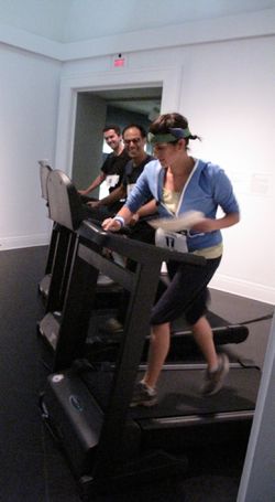
De 20 à 25 lecteurs marathoniens se relaieront en marchant ou courant sur un tapis roulant tout en récitant un texte sur la notion de vitesse, lors de l’événement Lecture rapide. Les lecteurs-coureurs présenteront au public leur manifeste de la vitesse, éloge de la lenteur, traité philosophique, emploi du temps, extrait littéraire, recette, texte sur le continuum(...)
De 20 à 25 lecteurs marathoniens se relaieront en marchant ou courant sur un tapis roulant tout en récitant un texte sur la notion de vitesse, lors de l’événement Lecture rapide. Les lecteurs-coureurs présenteront au public leur manifeste de la vitesse, éloge de la lenteur, traité philosophique, emploi du temps, extrait littéraire, recette, texte sur le continuum(...)
Localisation:
Libraire du CCA et salles
Libraire du CCA et salles
Date:
20 septembre 2009
20 septembre 2009
Titre:
Lecture rapide
Actions:
Description:
De 20 à 25 lecteurs marathoniens se relaieront en marchant ou courant sur un tapis roulant tout en récitant un texte sur la notion de vitesse, lors de l’événement Lecture rapide. Les lecteurs-coureurs présenteront au public leur manifeste de la vitesse, éloge de la lenteur, traité philosophique, emploi du temps, extrait littéraire, recette, texte sur le continuum(...)
Classification:
événements
événements
Date:
20 septembre 2009
20 septembre 2009
Localisation:
Libraire du CCA et salles
Libraire du CCA et salles
Niveau de description archivistique:
Projet
Projet
Titre:
Red Line (1972)
Red Line (1972)
Numéro de référence:
AP207.S1.1972.PR04
Description:
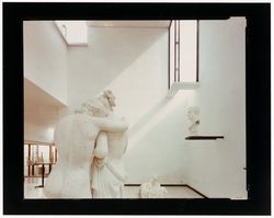
The project series documents "Red Line", a performance that consisted in tracing a red line in the middle of the road with paint sprayer and compressor loaded on the back of a truck. The red line stretched across forty-five kilometres of road and traced the limits of the municipality of Salt Lake City. "The red line rendered visible the boundaries that structure our mental fields of perception and modify our understanding of space." [1] The performance was carried out in February and March 1972 with a group of students from the University of Utah, in Salt Lake City. The project series contains photographs of Pettena and his team at work tracing the red line, a drawing, and a map of the Salt Lake City municipality showing the trajectory of the line. Source: [1] Marco Scotini, editor. Non-conscious architecture: Gianni Pettena, Sternberg Press, 2018, 235 pages. p. 168.
AP207.S1.1972.PR04
Description:
The project series documents "Red Line", a performance that consisted in tracing a red line in the middle of the road with paint sprayer and compressor loaded on the back of a truck. The red line stretched across forty-five kilometres of road and traced the limits of the municipality of Salt Lake City. "The red line rendered visible the boundaries that structure our mental fields of perception and modify our understanding of space." [1] The performance was carried out in February and March 1972 with a group of students from the University of Utah, in Salt Lake City. The project series contains photographs of Pettena and his team at work tracing the red line, a drawing, and a map of the Salt Lake City municipality showing the trajectory of the line. Source: [1] Marco Scotini, editor. Non-conscious architecture: Gianni Pettena, Sternberg Press, 2018, 235 pages. p. 168.
Personnes et institutions:
Date:
circa 1972-2015
circa 1972-2015
Titre:
Red Line (1972)
Actions:
AP207.S1.1972.PR04
Description:
The project series documents "Red Line", a performance that consisted in tracing a red line in the middle of the road with paint sprayer and compressor loaded on the back of a truck. The red line stretched across forty-five kilometres of road and traced the limits of the municipality of Salt Lake City. "The red line rendered visible the boundaries that structure our mental fields of perception and modify our understanding of space." [1] The performance was carried out in February and March 1972 with a group of students from the University of Utah, in Salt Lake City. The project series contains photographs of Pettena and his team at work tracing the red line, a drawing, and a map of the Salt Lake City municipality showing the trajectory of the line. Source: [1] Marco Scotini, editor. Non-conscious architecture: Gianni Pettena, Sternberg Press, 2018, 235 pages. p. 168.
Niveau de description archivistique:
Project
Project
Date:
circa 1972-2015
circa 1972-2015
Personnes et institutions: