5683 Résultats
Classification:
dessins
Quantité:
26 reprographic copy(ies)
dessins
Quantité:
26 reprographic copy(ies)
Numéro de référence:
ARCH256061
ARCH256061
Personnes et institutions:
Classification:
dessins
Quantité:
26 reprographic copy(ies)
dessins
Quantité:
26 reprographic copy(ies)
Personnes et institutions:
Classification:
dessins
Quantité:
13 File
dessins
Quantité:
13 File
Numéro de référence:
ARCH261866
ARCH261866
Personnes et institutions:
Date:
1978
1978
Classification:
dessins
Quantité:
13 File
dessins
Quantité:
13 File
Date:
1978
1978
Personnes et institutions:
Classification:
dessins
dessins
Numéro de référence:
AP018.S1.1973.PR06.006
AP018.S1.1973.PR06.006
Personnes et institutions:
Date:
1974-1975
1974-1975
Titre:
Site plans and land survey, Gordie Howe Sports Centre, Mississauga, Ontario
Actions:
AP018.S1.1973.PR06.006
Site plans and land survey, Gordie Howe Sports Centre, Mississauga, Ontario
Actions:
AP018.S1.1973.PR06.006
Classification:
dessins
dessins
Date:
1974-1975
1974-1975
Personnes et institutions:
Classification:
photographies
photographies
![View of dry land, trees and shrubs with a dwelling in the background, Europe[?]](/img-collection/TNRNH3Dok07XYkehVz4qLNoJ1wE=/500x366/348989.jpg)
Actions:
Numéro de référence:
PH1986:0107:029
PH1986:0107:029
Personnes et institutions:
Sujet:
architecture, topographique
architecture, topographique
Date:
between late 1860s and mid 1870s
between late 1860s and mid 1870s
Titre:
View of dry land, trees and shrubs with a dwelling in the background, Europe[?]
Actions:
PH1986:0107:029
View of dry land, trees and shrubs with a dwelling in the background, Europe[?]
Actions:
PH1986:0107:029
Classification:
photographies
photographies
Date:
between late 1860s and mid 1870s
between late 1860s and mid 1870s
Personnes et institutions:
Sujet:
architecture, topographique
architecture, topographique
Classification:
dessins
Quantité:
28 File
dessins
Quantité:
28 File
Numéro de référence:
ARCH79824
Description:
early conceptual sketch plans, site plan sketches showing land contours and existing conditions, schematic site / floor plans, parking area plans, building sections and details
ARCH79824
Description:
early conceptual sketch plans, site plan sketches showing land contours and existing conditions, schematic site / floor plans, parking area plans, building sections and details
Personnes et institutions:
Date:
circa 1947-2002
circa 1947-2002
Titre:
Early conceptual sketch plans, site plan sketches showing land contours and existing conditions
Actions:
ARCH79824
Description:
early conceptual sketch plans, site plan sketches showing land contours and existing conditions, schematic site / floor plans, parking area plans, building sections and details
Classification:
dessins
Quantité:
28 File
dessins
Quantité:
28 File
Date:
circa 1947-2002
circa 1947-2002
Personnes et institutions:
Classification:
photographies
photographies
Actions:
Numéro de référence:
PH2003:0126
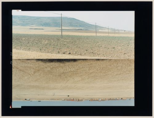
Description:
The two images that form this diptych are arranged bottom to bottom, producing the impression of a mirror image, though they show different views. This photograph was taken as part of the ‘In Between Cities’ project, but it was not published in the book 'In between cities'.
PH2003:0126
Description:
The two images that form this diptych are arranged bottom to bottom, producing the impression of a mirror image, though they show different views. This photograph was taken as part of the ‘In Between Cities’ project, but it was not published in the book 'In between cities'.
Personnes et institutions:
Sujet:
architecture, topographique
architecture, topographique
Date:
August 1995
August 1995
Titre:
Diptych of agricultural land and farms in one image, agricultural land, utility poles and a hill in the other image, Castrojeriz, Burgos Province, Spain (from the series "In between cities")
Actions:
PH2003:0126
Description:
The two images that form this diptych are arranged bottom to bottom, producing the impression of a mirror image, though they show different views. This photograph was taken as part of the ‘In Between Cities’ project, but it was not published in the book 'In between cities'.
Classification:
photographies
photographies
Date:
August 1995
August 1995
Personnes et institutions:
Sujet:
architecture, topographique
architecture, topographique
Classification:
dessins
dessins
Numéro de référence:
AP018.S1.1974.PR21.002
AP018.S1.1974.PR21.002
Personnes et institutions:
Date:
1973-1974
1973-1974
Titre:
Sketch site plans, Toronto International Airport, Land Use Study, Mississauga, Ontario
Actions:
AP018.S1.1974.PR21.002
Sketch site plans, Toronto International Airport, Land Use Study, Mississauga, Ontario
Actions:
AP018.S1.1974.PR21.002
Classification:
dessins
dessins
Date:
1973-1974
1973-1974
Personnes et institutions:
Classification:
photographies
photographies
Titre:
View of the Hampi bazaar with agricultural land in the foreground, Vijayanagara, Hampi, India
View of the Hampi bazaar with agricultural land in the foreground, Vijayanagara, Hampi, India
Actions:
Numéro de référence:
PH1986:1164
PH1986:1164
Personnes et institutions:
Sujet:
architecture, topographique
architecture, topographique
Date:
1985
1985
Titre:
View of the Hampi bazaar with agricultural land in the foreground, Vijayanagara, Hampi, India
Actions:
PH1986:1164
View of the Hampi bazaar with agricultural land in the foreground, Vijayanagara, Hampi, India
Actions:
PH1986:1164
Classification:
photographies
photographies
Date:
1985
1985
Personnes et institutions:
Sujet:
architecture, topographique
architecture, topographique
Classification:
documents textuels
documents textuels
Numéro de référence:
ARCH401822
ARCH401822
Personnes et institutions:
Date:
circa 1970
circa 1970
Classification:
documents textuels
documents textuels
Date:
circa 1970
circa 1970
Personnes et institutions:
Classification:
dessins
Quantité:
20 design development drawing(s)
dessins
Quantité:
20 design development drawing(s)
Numéro de référence:
DR2004:0231
Description:
site plans, some showing land use, communication, and climate, diagrammatic plans of Steel House, some showing flexible variations, plans, typical site plans and sections, regional map, and elevations
DR2004:0231
Description:
site plans, some showing land use, communication, and climate, diagrammatic plans of Steel House, some showing flexible variations, plans, typical site plans and sections, regional map, and elevations
Personnes et institutions:
Titre:
Site plans, some showing land use, communication, and climate, diagrammatic plans of Steel House
Actions:
DR2004:0231
Description:
site plans, some showing land use, communication, and climate, diagrammatic plans of Steel House, some showing flexible variations, plans, typical site plans and sections, regional map, and elevations
Classification:
dessins
Quantité:
20 design development drawing(s)
dessins
Quantité:
20 design development drawing(s)
Personnes et institutions: