2698 Résultats
Classification:
cartes
cartes
Actions:
Exemplaires:
Description:
79 pages, 230 leaves of plates : illustrations, facsimiles ; 34 x 45 cm
Description:
79 pages, 230 leaves of plates : illustrations, facsimiles ; 34 x 45 cm
Auteur:
Sujet:
Publication:
Wien : Gerlach & Wiedling, 1925.
Wien : Gerlach & Wiedling, 1925.
Titre:
Historischer Atlas der Wiener Ansichten : das barocke Wien / herausgegeben von Max Eisler.
Actions:
Exemplaires:
Description:
79 pages, 230 leaves of plates : illustrations, facsimiles ; 34 x 45 cm
Historischer Atlas der Wiener Ansichten : das barocke Wien / herausgegeben von Max Eisler.
Actions:
Exemplaires:
Description:
79 pages, 230 leaves of plates : illustrations, facsimiles ; 34 x 45 cm
Classification:
cartes
cartes
Publication:
Wien : Gerlach & Wiedling, 1925.
Wien : Gerlach & Wiedling, 1925.
Auteur:
Sujet:
Classification:
livres
livres
Actions:
Exemplaires:
Description:
x, 190 pages : illustrations, maps, plans ; 18 cm
Description:
x, 190 pages : illustrations, maps, plans ; 18 cm
Auteur:
Sujet:
Publication:
Boston : Ginn & Company, 1903.
Boston : Ginn & Company, 1903.
Titre:
Boston; a guide book / by Edwin M. Bacon. [Prepared for the Convention of the National educational association, July 6-10, 1903, under the direction of Edwin D. Mead, Frank Foxcroft, and George P. Morris, the committee on guide books appointed by the local executive committee].
Actions:
Exemplaires:
Description:
x, 190 pages : illustrations, maps, plans ; 18 cm
Classification:
livres
livres
Publication:
Boston : Ginn & Company, 1903.
Boston : Ginn & Company, 1903.
Auteur:
Sujet:
Classification:
livres
livres
Actions:
Exemplaires:
Description:
xxx, 174 pages, 21 unnumbered leaves of plates (13 folded) : illustrations, maps ; 25 cm
Description:
xxx, 174 pages, 21 unnumbered leaves of plates (13 folded) : illustrations, maps ; 25 cm
Auteur:
Sujet:
Publication:
Roma : Multigrafica, 1973.
Roma : Multigrafica, 1973.
Titre:
Piante e vedute di Firenze : studio storico topografico cartografico / di Giuseppe Boffito e Attilio Mori, dedicato al municipio di Firenze.
Actions:
Exemplaires:
Description:
xxx, 174 pages, 21 unnumbered leaves of plates (13 folded) : illustrations, maps ; 25 cm
Piante e vedute di Firenze : studio storico topografico cartografico / di Giuseppe Boffito e Attilio Mori, dedicato al municipio di Firenze.
Actions:
Exemplaires:
Description:
xxx, 174 pages, 21 unnumbered leaves of plates (13 folded) : illustrations, maps ; 25 cm
Classification:
livres
livres
Publication:
Roma : Multigrafica, 1973.
Roma : Multigrafica, 1973.
Auteur:
Sujet:
Classification:
cartes
cartes
Actions:
Exemplaires:
Description:
2 maps on 74 sheets : col. ; sheets 34 x 31 cm.
Description:
2 maps on 74 sheets : col. ; sheets 34 x 31 cm.
Auteur:
Sujet:
Publication:
[Toronto] : The Bureau, [1952-1967]
[Toronto] : The Bureau, [1952-1967]
Titre:
Insurance plan of the city of Halifax, population, city and district, approximately 104,500. [Volume 1] : plan dated August 1952 : partially revised 1961, 1963, 1964, 1965 / compiled and issued by Underwriter's Survey Bureau, Limited.
Actions:
Exemplaires:
Description:
2 maps on 74 sheets : col. ; sheets 34 x 31 cm.
Classification:
cartes
cartes
Publication:
[Toronto] : The Bureau, [1952-1967]
[Toronto] : The Bureau, [1952-1967]
Auteur:
Sujet:
Classification:
livres
livres
Actions:
Exemplaires:
Description:
345 pages, 1 unnumbered leaf of plates : illustrations, maps ; 25 cm
Description:
345 pages, 1 unnumbered leaf of plates : illustrations, maps ; 25 cm
Auteur:
Sujet:
Publication:
Padova : La Garangola, 1981.
Padova : La Garangola, 1981.
Titre:
Le mappe e i disegni dell'Archivio di Piazzola sul Brenta : cartografia storica e analisi territoriale / Gianna Suitner Nicolini.
Actions:
Exemplaires:
Description:
345 pages, 1 unnumbered leaf of plates : illustrations, maps ; 25 cm
Le mappe e i disegni dell'Archivio di Piazzola sul Brenta : cartografia storica e analisi territoriale / Gianna Suitner Nicolini.
Actions:
Exemplaires:
Description:
345 pages, 1 unnumbered leaf of plates : illustrations, maps ; 25 cm
Classification:
livres
livres
Publication:
Padova : La Garangola, 1981.
Padova : La Garangola, 1981.
Auteur:
Sujet:
Classification:
livres
livres
Actions:
Exemplaires:
Description:
280 pages : illustrations (chiefly color), maps (chiefly color) ; 35 cm
Description:
280 pages : illustrations (chiefly color), maps (chiefly color) ; 35 cm
Auteur:
Sujet:
Publication:
Vancouver : Douglas & McIntyre, [2006], ©2006
Vancouver : Douglas & McIntyre, [2006], ©2006
Titre:
Historical atlas of the United States, with original maps/ Derek Hayes.
Actions:
Exemplaires:
Description:
280 pages : illustrations (chiefly color), maps (chiefly color) ; 35 cm
Historical atlas of the United States, with original maps/ Derek Hayes.
Actions:
Exemplaires:
Description:
280 pages : illustrations (chiefly color), maps (chiefly color) ; 35 cm
Classification:
livres
livres
Publication:
Vancouver : Douglas & McIntyre, [2006], ©2006
Vancouver : Douglas & McIntyre, [2006], ©2006
Auteur:
Sujet:
Classification:
livres
livres
Actions:
Exemplaires:
Description:
1 portfolio (31 pages, 12 leaves of plates) : illustrations ; 51 cm.
Description:
1 portfolio (31 pages, 12 leaves of plates) : illustrations ; 51 cm.
Auteur:
Sujet:
Publication:
[Città del Vaticana] : [Biblioteca Apostolica Vatican], [1980?]
[Città del Vaticana] : [Biblioteca Apostolica Vatican], [1980?]
Titre:
Roma al tempo di Urbano VIII : la pianta di Roma Maggi-Maupin-Losi del 1625, riprodatta da uno dei due esemplari completi finora conoscuiti a cura della Biblioteca Vaticana / con introd. di Franceso Ehrle.
Actions:
Exemplaires:
Description:
1 portfolio (31 pages, 12 leaves of plates) : illustrations ; 51 cm.
Classification:
livres
livres
Publication:
[Città del Vaticana] : [Biblioteca Apostolica Vatican], [1980?]
[Città del Vaticana] : [Biblioteca Apostolica Vatican], [1980?]
Auteur:
Sujet:
Classification:
livres
livres
Actions:
Exemplaires:
Description:
xv,376,[16]p. of plates : ill., facsims.(some col.),maps,plans ; 38cm.
Description:
xv,376,[16]p. of plates : ill., facsims.(some col.),maps,plans ; 38cm.
Auteur:
Sujet:
Publication:
Oxford : Clarendon, 1986.
Oxford : Clarendon, 1986.
Titre:
Local maps and plans from medieval England / edited by R.A. Skelton and P.D.A. Harvey.
Actions:
Exemplaires:
Description:
xv,376,[16]p. of plates : ill., facsims.(some col.),maps,plans ; 38cm.
Local maps and plans from medieval England / edited by R.A. Skelton and P.D.A. Harvey.
Actions:
Exemplaires:
Description:
xv,376,[16]p. of plates : ill., facsims.(some col.),maps,plans ; 38cm.
Classification:
livres
livres
Publication:
Oxford : Clarendon, 1986.
Oxford : Clarendon, 1986.
Auteur:
Sujet:
Classification:
livres
livres
Actions:
Prix:
$57.00
(disponible en magasin)
Résumé:
Since the invention of photography in the nineteenth century, Africa has been defined largely by Western images of its cultures and traditions. From the colonial carte de visite and ethnographic archive to the rise of studio portraiture and social documents of racial surveillance, the fraught relationship between Africa and the photographic lens has become inseparable(...)
Titre:
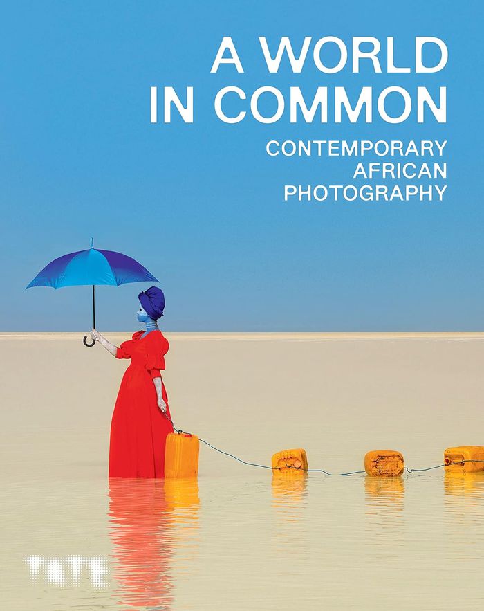
A world in common: Contemporary African photography
Actions:
Prix:
$57.00
(disponible en magasin)
Résumé:
Since the invention of photography in the nineteenth century, Africa has been defined largely by Western images of its cultures and traditions. From the colonial carte de visite and ethnographic archive to the rise of studio portraiture and social documents of racial surveillance, the fraught relationship between Africa and the photographic lens has become inseparable from the discourses of post-colonialism. Challenging these dominant images of exoticism and otherness, this book illustrates how photography has allowed artists to reimagine African histories through the lens of the present, to shape our understanding of the contemporary realities we face. Bringing together a diverse range of artists and thinkers to present varied perspectives on issues such as cultural heritage and restitution, spirituality, urbanism and climate change, it reveals how innovative contemporary photography challenges perceptions of history, culture and identity.
Classification:
livres
livres
Publication:
juillet 2023
juillet 2023
Sujet:
Photographie- collections
Photographie- collections
Classification:
livres
livres
Actions:
Prix:
$72.00
(disponible en magasin)
Résumé:
This catalog traces German photographer Wolfgang Tillmans' unique 2025 project at the Centre Pompidou, for which he was given a generous carte blanche. The result occupied the entire second floor of the Public Information Library, where Tillmans' experimental installation transformed the space, establishing a dialogue with the former library and questioning it both as(...)
Titre:
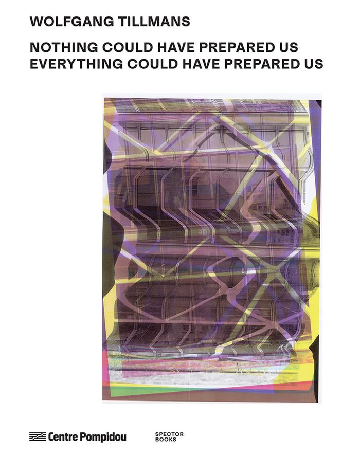
Wolfgang Tillmans: Nothing could have prepared us – Everything could have prepared us
Actions:
Prix:
$72.00
(disponible en magasin)
Résumé:
This catalog traces German photographer Wolfgang Tillmans' unique 2025 project at the Centre Pompidou, for which he was given a generous carte blanche. The result occupied the entire second floor of the Public Information Library, where Tillmans' experimental installation transformed the space, establishing a dialogue with the former library and questioning it both as architecture and as a locus for the transmission of knowledge. The work explores over 35 years of artistic practice through various photographic genres and constitutes another very personal representation of his universe, whose order and logic are activated in response to the library space. With 600 images, an index of the works alternates with numerous installation shots that show how the artist made this space his own, while a varied selection of essays by a younger generation of authors sheds new light on the various aspects of Tillmans' work.
Classification:
livres
livres
Publication:
avril 2026
avril 2026
Sujet:
Monographies photo
Monographies photo