2698 Résultats
Classification:
livres
livres
Actions:
Prix:
$21.00
(disponible sur commande)
Résumé:
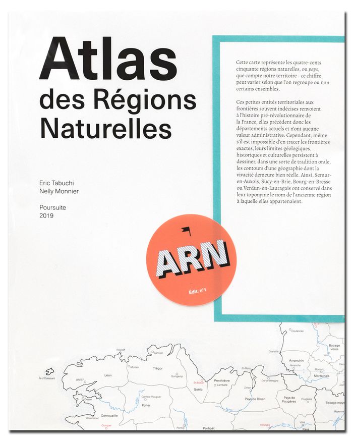
'L’Atlas des Régions Naturelles' (ARN) se donne pour objet la création d’une archive photographique documentant la grande diversité - mais aussi leur uniformisation progressive - des paysages et plus particulièrement des bâtis que l’on rencontre sur le territoire français. Commencé en 2017, il devrait être achevé en 2024. Cette carte représente les quatre-cents-cinquante(...)
$21.00
(disponible sur commande)
Résumé:
'L’Atlas des Régions Naturelles' (ARN) se donne pour objet la création d’une archive photographique documentant la grande diversité - mais aussi leur uniformisation progressive - des paysages et plus particulièrement des bâtis que l’on rencontre sur le territoire français. Commencé en 2017, il devrait être achevé en 2024. Cette carte représente les quatre-cents-cinquante(...)
Titre:
Atlas des régions naturelles (ARN)
Actions:
Prix:
$21.00
(disponible sur commande)
Résumé:
'L’Atlas des Régions Naturelles' (ARN) se donne pour objet la création d’une archive photographique documentant la grande diversité - mais aussi leur uniformisation progressive - des paysages et plus particulièrement des bâtis que l’on rencontre sur le territoire français. Commencé en 2017, il devrait être achevé en 2024. Cette carte représente les quatre-cents-cinquante régions naturelles de France, petites entités territoriales aux frontières souvent indécises, renvoient à l’histoire pré-révolutionnaire, elles précèdent donc les départements actuels et n’ont aucune valeur administrative. Cependant, même s’il est impossible d’en tracer les frontières exactes, leurs limites géologiques, historiques et culturelles persistent à dessiner, dans une sorte de tradition orale, les contours d’une géographie dont la vivacité demeure bien réelle. Ainsi, Semur-en-Auxois, Sucy-en-Brie, Bourg-en-Bresse ou Verdun-en-Lauragais ont conservé dans leur toponyme le nom de l’ancienne région à laquelle elles appartenaient.
Classification:
livres
livres
Publication:
juin 2020
juin 2020
Sujet:
Monographies photo
Monographies photo
Classification:
livres
livres
Actions:
Prix:
$45.00
(disponible sur commande)
Résumé:
In 1967, for her first museum retrospective, Louise Nevelson (1899–1988) was given carte blanche to transform the Rose Art Museum at Brandeis University into an all-emcompassing, theatrical environment for her sculpture. Nevelson installed her show across the whole museum, draping the walls of the permanent collection with the colors that reflected the black, white, gold(...)
Titre:
Louise Nevelson: I must recompose the environment
Actions:
Prix:
$45.00
(disponible sur commande)
Résumé:
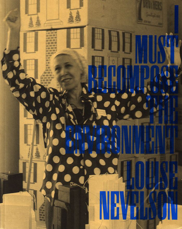
In 1967, for her first museum retrospective, Louise Nevelson (1899–1988) was given carte blanche to transform the Rose Art Museum at Brandeis University into an all-emcompassing, theatrical environment for her sculpture. Nevelson installed her show across the whole museum, draping the walls of the permanent collection with the colors that reflected the black, white, gold and navy palette of her works. “Louise Nevelson: I Must Recompose the Environment “ includes previously unpublished exhibition layouts (annotated by Nevelson), installation photographs and texts that place this show in the context of Nevelson's career and the museum’s early history. This publication accompanies the now out-of-print catalog of the 1967 show organized in collaboration with the Whitney Museum and serves as a document both of the then-nascent museum and the solidifying legacy of an artistic icon.
Louise Nevelson: I must recompose the environment
Actions:
Prix:
$45.00
(disponible sur commande)
Résumé:
In 1967, for her first museum retrospective, Louise Nevelson (1899–1988) was given carte blanche to transform the Rose Art Museum at Brandeis University into an all-emcompassing, theatrical environment for her sculpture. Nevelson installed her show across the whole museum, draping the walls of the permanent collection with the colors that reflected the black, white, gold and navy palette of her works. “Louise Nevelson: I Must Recompose the Environment “ includes previously unpublished exhibition layouts (annotated by Nevelson), installation photographs and texts that place this show in the context of Nevelson's career and the museum’s early history. This publication accompanies the now out-of-print catalog of the 1967 show organized in collaboration with the Whitney Museum and serves as a document both of the then-nascent museum and the solidifying legacy of an artistic icon.
Classification:
livres
livres
Publication:
juin 2019
juin 2019
Classification:
livres
livres
Actions:
Exemplaires:
Description:
3 volumes : illustrations (some color) ; 29 cm.
- Bibliothèque main 199107 | NA44.L364.A35 1977 | v. 1 | Disponible
- Bibliothèque main 199106 | NA44.L364.A35 1977 | v. 2 | Disponible
- Bibliothèque main 199105 | NA44.L364.A35 1977 | v. 3 | Disponible
Description:
3 volumes : illustrations (some color) ; 29 cm.
Auteur:
- Latrobe, Benjamin Henry, 1764-1820.,
- Carter, Edward C., II, 1928-2002.,
- Maryland Historical Society.
Sujet:
- Latrobe, Benjamin Henry, 1764-1820.,
- Architects United States Biography.,
- Architectes États-Unis Biographies.,
- Architects,
- Manners and customs,
- Virginia Social life and customs To 1775.,
- Virginie Mœurs et coutumes Jusqu'à 1775.,
- United States,
- Virginia,
- Writings.,
- Biographies
Publication:
New Haven : Published for the Maryland Historical Society by Yale University Press, 1977-1980.
New Haven : Published for the Maryland Historical Society by Yale University Press, 1977-1980.
Titre:
The Virginia journals of Benjamin Henry Latrobe, 1795-1798 / Edward C. Carter II, editor, Angeline Polites, associate editor ; Lee W. Formwalt and John C. Van Horne, editorial assistants.
Actions:
Exemplaires:
Description:
3 volumes : illustrations (some color) ; 29 cm.
The Virginia journals of Benjamin Henry Latrobe, 1795-1798 / Edward C. Carter II, editor, Angeline Polites, associate editor ; Lee W. Formwalt and John C. Van Horne, editorial assistants.
Actions:
Exemplaires:
- Bibliothèque main 199107 | NA44.L364.A35 1977 | v. 1 | Disponible
- Bibliothèque main 199106 | NA44.L364.A35 1977 | v. 2 | Disponible
- Bibliothèque main 199105 | NA44.L364.A35 1977 | v. 3 | Disponible
Description:
3 volumes : illustrations (some color) ; 29 cm.
Classification:
livres
livres
Publication:
New Haven : Published for the Maryland Historical Society by Yale University Press, 1977-1980.
New Haven : Published for the Maryland Historical Society by Yale University Press, 1977-1980.
Auteur:
- Latrobe, Benjamin Henry, 1764-1820.,
- Carter, Edward C., II, 1928-2002.,
- Maryland Historical Society.
Sujet:
- Latrobe, Benjamin Henry, 1764-1820.,
- Architects United States Biography.,
- Architectes États-Unis Biographies.,
- Architects,
- Manners and customs,
- Virginia Social life and customs To 1775.,
- Virginie Mœurs et coutumes Jusqu'à 1775.,
- United States,
- Virginia,
- Writings.,
- Biographies
Classification:
cartes
cartes
Actions:
Exemplaires:
Description:
[iv], 21 double leaves : maps ; 45 cm
Description:
[iv], 21 double leaves : maps ; 45 cm
Auteur:
Sujet:
- Streets England London Maps.,
- Streets,
- London (England) Maps Early works to 1800.,
- England London,
- Maps.,
- Early works,
- Cartes géographiques.
Publication:
Lympne Castle : Harry Margary, in association with Guildhall Library, London, 1976.
Lympne Castle : Harry Margary, in association with Guildhall Library, London, 1976.
Titre:
A large and accurate map of the city of London : ichnographically describing all the streets, lanes, alleys, courts, yards, churches, halls and houses, &c. / actually surveyed and delineated by John Ogilby ; introductory notes by Ralph Hyde.
Actions:
Exemplaires:
Description:
[iv], 21 double leaves : maps ; 45 cm
Classification:
cartes
cartes
Publication:
Lympne Castle : Harry Margary, in association with Guildhall Library, London, 1976.
Lympne Castle : Harry Margary, in association with Guildhall Library, London, 1976.
Auteur:
Sujet:
- Streets England London Maps.,
- Streets,
- London (England) Maps Early works to 1800.,
- England London,
- Maps.,
- Early works,
- Cartes géographiques.
Classification:
livres
livres
Actions:
Exemplaires:
Description:
xix, 300 pages : maps ; 24 x 31 cm
Description:
xix, 300 pages : maps ; 24 x 31 cm
Auteur:
Sujet:
- Hudson's Bay Company Maps.,
- Hudson's Bay Company Map collections Catalogs.,
- Hudson's Bay Company Maps Catalogs.,
- Hudson's Bay Company Map collections.,
- Compagnie de la Baie d'Hudson Cartes,
- Compagnie de la Baie d'Hudson Collections de cartes Catalogues,
- Compagnie de la Baie d'Hudson Cartes Catalogues,
- Hudson's Bay Company,
- Hudson's Bay Company Cartes.,
- Cartography Canada History.,
- Cartography Hudson Bay Region.,
- Canada Historical geography Maps.,
- Cartographie Canada Histoire.,
- History of cartography. [Literature].,
- Cartography,
- Discoveries in geography British,
- Map collections,
- Maps,
- Hudson's Bay Company Archives Catalogs.,
- Hudson's Bay Company History.,
- Kaarten (geografie),
- Bonthandel.,
- 528.9(091) -- History of cartography.,
- 061.5 -- Business enterprises: Hudson's Bay Company.,
- 339 -- Trade.,
- 91(091) -- Exploration, history.,
- 93 -- History.,
- Canada Discovery and exploration British.,
- Canada Géographie historique Cartes,
- Canada Découverte et exploration britanniques,
- Canada Géographie historique Cartes Catalogues,
- Canada. [Literature] 1991.,
- Canada,
- Hudson Bay Region,
- Canada, Manitoba, Winnipeg Archives and libraries Inventories, registers, catalogs.,
- Canada Découverte et exploration britaniques.,
- (*41) -- Canada.,
- Catalogs,
- History,
- Cartes géographiques.
Publication:
Montreal ; Buffalo : McGill-Queen's University Press, ©1991.
Montreal ; Buffalo : McGill-Queen's University Press, ©1991.
Titre:
A country so interesting : the Hudson's Bay Company and two centuries of mapping, 1670-1870 / Richard I. Ruggles.
Actions:
Exemplaires:
Description:
xix, 300 pages : maps ; 24 x 31 cm
A country so interesting : the Hudson's Bay Company and two centuries of mapping, 1670-1870 / Richard I. Ruggles.
Actions:
Exemplaires:
Description:
xix, 300 pages : maps ; 24 x 31 cm
Classification:
livres
livres
Publication:
Montreal ; Buffalo : McGill-Queen's University Press, ©1991.
Montreal ; Buffalo : McGill-Queen's University Press, ©1991.
Auteur:
Sujet:
- Hudson's Bay Company Maps.,
- Hudson's Bay Company Map collections Catalogs.,
- Hudson's Bay Company Maps Catalogs.,
- Hudson's Bay Company Map collections.,
- Compagnie de la Baie d'Hudson Cartes,
- Compagnie de la Baie d'Hudson Collections de cartes Catalogues,
- Compagnie de la Baie d'Hudson Cartes Catalogues,
- Hudson's Bay Company,
- Hudson's Bay Company Cartes.,
- Cartography Canada History.,
- Cartography Hudson Bay Region.,
- Canada Historical geography Maps.,
- Cartographie Canada Histoire.,
- History of cartography. [Literature].,
- Cartography,
- Discoveries in geography British,
- Map collections,
- Maps,
- Hudson's Bay Company Archives Catalogs.,
- Hudson's Bay Company History.,
- Kaarten (geografie),
- Bonthandel.,
- 528.9(091) -- History of cartography.,
- 061.5 -- Business enterprises: Hudson's Bay Company.,
- 339 -- Trade.,
- 91(091) -- Exploration, history.,
- 93 -- History.,
- Canada Discovery and exploration British.,
- Canada Géographie historique Cartes,
- Canada Découverte et exploration britanniques,
- Canada Géographie historique Cartes Catalogues,
- Canada. [Literature] 1991.,
- Canada,
- Hudson Bay Region,
- Canada, Manitoba, Winnipeg Archives and libraries Inventories, registers, catalogs.,
- Canada Découverte et exploration britaniques.,
- (*41) -- Canada.,
- Catalogs,
- History,
- Cartes géographiques.
Classification:
livres
livres
Actions:
Exemplaires:
Description:
160 pages : illustrations, maps (1 color), portraits ; 21 cm
Description:
160 pages : illustrations, maps (1 color), portraits ; 21 cm
Sujet:
- Verdun, Battle of, Verdun, France, 1914.,
- Verdun, Battle of, Verdun, France, 1916.,
- World War, 1914-1918 Battlefields France Verdun Guidebooks.,
- Automobile travel France Verdun Guidebooks.,
- Bataille de Verdun, Verdun, France, 1914.,
- Bataille de Verdun, Verdun, France, 1916.,
- Guerre mondiale, 1914-1918 Champs de bataille France Verdun (Meuse) Guides.,
- Voyages en automobile France Verdun (Meuse) Guides.,
- Automobile travel,
- Battlefields,
- Verdun (France) Guidebooks.,
- Verdun (France) History 20th century.,
- France Verdun,
- travel guidebooks.,
- maps (documents),
- military maps.,
- Military maps,
- Guidebooks,
- History,
- Road maps,
- Guides touristiques.,
- Cartes militaires.,
- Cartes routières.
Publication:
Verdun : Éditions Lorraines Frémont, [1966?]
Verdun : Éditions Lorraines Frémont, [1966?]
Titre:
Verdun : guide historique illustré.
Actions:
Exemplaires:
Description:
160 pages : illustrations, maps (1 color), portraits ; 21 cm
Verdun : guide historique illustré.
Actions:
Exemplaires:
Description:
160 pages : illustrations, maps (1 color), portraits ; 21 cm
Classification:
livres
livres
Publication:
Verdun : Éditions Lorraines Frémont, [1966?]
Verdun : Éditions Lorraines Frémont, [1966?]
Sujet:
- Verdun, Battle of, Verdun, France, 1914.,
- Verdun, Battle of, Verdun, France, 1916.,
- World War, 1914-1918 Battlefields France Verdun Guidebooks.,
- Automobile travel France Verdun Guidebooks.,
- Bataille de Verdun, Verdun, France, 1914.,
- Bataille de Verdun, Verdun, France, 1916.,
- Guerre mondiale, 1914-1918 Champs de bataille France Verdun (Meuse) Guides.,
- Voyages en automobile France Verdun (Meuse) Guides.,
- Automobile travel,
- Battlefields,
- Verdun (France) Guidebooks.,
- Verdun (France) History 20th century.,
- France Verdun,
- travel guidebooks.,
- maps (documents),
- military maps.,
- Military maps,
- Guidebooks,
- History,
- Road maps,
- Guides touristiques.,
- Cartes militaires.,
- Cartes routières.
Classification:
livres
livres
Actions:
Exemplaires:
Description:
81 p. ; ill., maps.
Description:
81 p. ; ill., maps.
Auteur:
Sujet:
- Real property Pennsylvania Lebanon County Maps.,
- Biens réels Pennsylvanie Lebanon (Comté) Cartes.,
- Real property.,
- Lebanon County (Pa.) Maps.,
- Lebanon County (Pa.) History.,
- Pennsylvania Lebanon County.,
- History.,
- Maps.
Publication:
Philadelphia : F.A. Davis, 1875.
Philadelphia : F.A. Davis, 1875.
Titre:
County atlas of Lebanon, Pennsylvania : from recent and actual surveys and records / under the superintendence of F.W. Beers.
Actions:
Exemplaires:
Description:
81 p. ; ill., maps.
County atlas of Lebanon, Pennsylvania : from recent and actual surveys and records / under the superintendence of F.W. Beers.
Actions:
Exemplaires:
Description:
81 p. ; ill., maps.
Classification:
livres
livres
Publication:
Philadelphia : F.A. Davis, 1875.
Philadelphia : F.A. Davis, 1875.
Auteur:
Sujet:
- Real property Pennsylvania Lebanon County Maps.,
- Biens réels Pennsylvanie Lebanon (Comté) Cartes.,
- Real property.,
- Lebanon County (Pa.) Maps.,
- Lebanon County (Pa.) History.,
- Pennsylvania Lebanon County.,
- History.,
- Maps.
Classification:
livres
livres
Actions:
Exemplaires:
Description:
239 pages : illustrations (some color), maps (some color) ; 30 cm.
Description:
239 pages : illustrations (some color), maps (some color) ; 30 cm.
Auteur:
Sujet:
- Cartography North America History.,
- Statistical maps History.,
- Cartography in art.,
- Cartographie Amérique du Nord Histoire.,
- Cartes statistiques Histoire.,
- Cartographie dans l'art.,
- Cartography,
- Statistical maps,
- Kartografie,
- Bildkarte.,
- Kartografi historia Nordamerika.,
- North America Maps.,
- North America,
- USA,
- Nordamerika kartor.,
- Maps.,
- Nonfiction.,
- History,
- Cartes géographiques.
Publication:
London : Black Dog Pub., ©2010.
London : Black Dog Pub., ©2010.
Titre:
Mapping America : exploring the continent / [Frank Jacobs, Fritz Kessler ; edited by Tom Howells and Duncan McCorquodale].
Actions:
Exemplaires:
Description:
239 pages : illustrations (some color), maps (some color) ; 30 cm.
Mapping America : exploring the continent / [Frank Jacobs, Fritz Kessler ; edited by Tom Howells and Duncan McCorquodale].
Actions:
Exemplaires:
Description:
239 pages : illustrations (some color), maps (some color) ; 30 cm.
Classification:
livres
livres
Publication:
London : Black Dog Pub., ©2010.
London : Black Dog Pub., ©2010.
Auteur:
Sujet:
- Cartography North America History.,
- Statistical maps History.,
- Cartography in art.,
- Cartographie Amérique du Nord Histoire.,
- Cartes statistiques Histoire.,
- Cartographie dans l'art.,
- Cartography,
- Statistical maps,
- Kartografie,
- Bildkarte.,
- Kartografi historia Nordamerika.,
- North America Maps.,
- North America,
- USA,
- Nordamerika kartor.,
- Maps.,
- Nonfiction.,
- History,
- Cartes géographiques.
Classification:
livres
livres
Actions:
Exemplaires:
Description:
30 pages, [1] folded leaf of plates : illustrations ; 33 cm
Description:
30 pages, [1] folded leaf of plates : illustrations ; 33 cm
Auteur:
Sujet:
- Streets France Paris.,
- City planning France Paris.,
- Rues France Paris.,
- City planning.,
- Streets.,
- Arrondissement (Paris, France),
- France Paris.,
- Maps.,
- Cartes géographiques.
Publication:
Paris : J. Renouard, 1842.
Paris : J. Renouard, 1842.
Titre:
Projets pour l'amélioration et l'embellissement du 10e arrondissement / par Léon de Laborde.
Actions:
Exemplaires:
Description:
30 pages, [1] folded leaf of plates : illustrations ; 33 cm
Projets pour l'amélioration et l'embellissement du 10e arrondissement / par Léon de Laborde.
Actions:
Exemplaires:
Description:
30 pages, [1] folded leaf of plates : illustrations ; 33 cm
Classification:
livres
livres
Publication:
Paris : J. Renouard, 1842.
Paris : J. Renouard, 1842.
Auteur:
Sujet:
- Streets France Paris.,
- City planning France Paris.,
- Rues France Paris.,
- City planning.,
- Streets.,
- Arrondissement (Paris, France),
- France Paris.,
- Maps.,
- Cartes géographiques.
Classification:
livres
livres
Actions:
Exemplaires:
Description:
179 pages : chiefly illustrations, maps (chiefly color) ; 34 cm
Description:
179 pages : chiefly illustrations, maps (chiefly color) ; 34 cm
Auteur:
Sujet:
- Cartography Germany Lower Saxony.,
- Early maps.,
- Cartographie Allemagne Basse-Saxe.,
- Cartes anciennes.,
- Cartography.,
- Kartografie,
- Karte,
- Historische Kartografie,
- Lower Saxony (Germany) Maps.,
- Germany Lower Saxony.,
- Niedersachsen,
- Maps.
Publication:
Neumünster : K. Wachholtz, 1985.
Neumünster : K. Wachholtz, 1985.
Titre:
Niedersachsen in alten Karten : eine Auswahl von Karten des 16. bis 18. Jahrhunderts aus den niedersächsischen Staatsarchiven / Heiko Leerhoff.
Actions:
Exemplaires:
Description:
179 pages : chiefly illustrations, maps (chiefly color) ; 34 cm
Niedersachsen in alten Karten : eine Auswahl von Karten des 16. bis 18. Jahrhunderts aus den niedersächsischen Staatsarchiven / Heiko Leerhoff.
Actions:
Exemplaires:
Description:
179 pages : chiefly illustrations, maps (chiefly color) ; 34 cm
Classification:
livres
livres
Publication:
Neumünster : K. Wachholtz, 1985.
Neumünster : K. Wachholtz, 1985.
Auteur:
Sujet:
- Cartography Germany Lower Saxony.,
- Early maps.,
- Cartographie Allemagne Basse-Saxe.,
- Cartes anciennes.,
- Cartography.,
- Kartografie,
- Karte,
- Historische Kartografie,
- Lower Saxony (Germany) Maps.,
- Germany Lower Saxony.,
- Niedersachsen,
- Maps.