7174 Résultats
Classification:
photographies
photographies
![View of the north façade of Block 3 (also known as Het Schip [The Ship]) showing the tower and oriel windows, Eigen Haard Housing Estate, Hembrugstraat, Spaarndammerbuurt, Amsterdam, Netherlands](/img-collection/DXHY5Bm9BgB_i1lK_2DKUejWyAw=/500x375/360886.jpg)
Actions:
Numéro de référence:
PH1984:0731
PH1984:0731
Personnes et institutions:
Sujet:
architecture
architecture
Date:
ca. 1970s
ca. 1970s
Classification:
photographies
photographies
Date:
ca. 1970s
ca. 1970s
Personnes et institutions:
Sujet:
architecture
architecture
Classification:
photographies
photographies
Actions:
Numéro de référence:
PH1982:0643:103
Description:
- This photograph was taken inside the fourth enclosure looking east towards the west façade of the central galleries and central towers.
PH1982:0643:103
Description:
- This photograph was taken inside the fourth enclosure looking east towards the west façade of the central galleries and central towers.
Personnes et institutions:
Sujet:
architecture
architecture
Date:
1866 or 1873
1866 or 1873
Titre:
View of the causeway showing the central galleries and central towers in the far distance and the north and south causeway libraries in the middle distance, Angkor Wat, Siam (now in Cambodia)
Actions:
PH1982:0643:103
Description:
- This photograph was taken inside the fourth enclosure looking east towards the west façade of the central galleries and central towers.
Classification:
photographies
photographies
Date:
1866 or 1873
1866 or 1873
Personnes et institutions:
Sujet:
architecture
architecture
Classification:
photographies
photographies
Actions:
Numéro de référence:
PH1993:0083
PH1993:0083
Personnes et institutions:
Date:
July 1987
July 1987
Classification:
photographies
photographies
Date:
July 1987
July 1987
Personnes et institutions:
Classification:
dessins
dessins
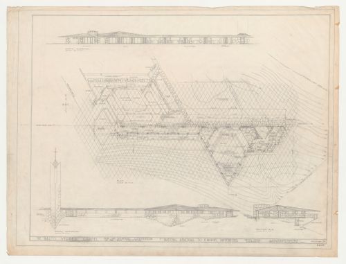
Numéro de référence:
DR1987:0706 R/V
Description:
- The site contours on this drawing for Wayfarers' Chapel, Palos Verdes, California, are delineated on the verso as is the equilateral parallelogram grid from which the plan was developed. The grid unit is inscribed on several orthographic drawings (eg. DR1987:0530) and is described by Lloyd Wright in the architect's statement (DR1987:0869:011:009).
Personnes et institutions:
Sujet:
architecture
architecture
Date:
30 August 1954
30 August 1954
Titre:
Wayfarers' Chapel, Palos Verdes, California: Plan developed on an equilateral parallelogram grid, north and south elevations and section for the cloister, cloister garden and parish house, including campanile as-built
Actions:
DR1987:0706 R/V
Description:
- The site contours on this drawing for Wayfarers' Chapel, Palos Verdes, California, are delineated on the verso as is the equilateral parallelogram grid from which the plan was developed. The grid unit is inscribed on several orthographic drawings (eg. DR1987:0530) and is described by Lloyd Wright in the architect's statement (DR1987:0869:011:009).
Classification:
dessins
dessins
Date:
30 August 1954
30 August 1954
Personnes et institutions:
Sujet:
architecture
architecture
Classification:
photographies
photographies
Actions:
Numéro de référence:
PH1982:0843
PH1982:0843
Personnes et institutions:
Sujet:
architecture
architecture
Date:
between 1856 and 1858
between 1856 and 1858
Classification:
photographies
photographies
Date:
between 1856 and 1858
between 1856 and 1858
Personnes et institutions:
Sujet:
architecture
architecture
Classification:
photographies
photographies
Actions:
Numéro de référence:
PH1982:0849
PH1982:0849
Personnes et institutions:
Sujet:
architecture
architecture
Date:
between 1856 and 1858
between 1856 and 1858
Classification:
photographies
photographies
Date:
between 1856 and 1858
between 1856 and 1858
Personnes et institutions:
Sujet:
architecture
architecture
Classification:
dessins
dessins
Numéro de référence:
DR2004:0358:004
DR2004:0358:004
Personnes et institutions:
Date:
1998 or 1999
1998 or 1999
Classification:
dessins
dessins
Date:
1998 or 1999
1998 or 1999
Personnes et institutions:
Classification:
photographies
photographies
Actions:
Numéro de référence:
PH1984:1203:020
Description:
- This photograph was taken from the top of Victoria Peak, looking northeast. The Cricket Ground is visible at lower left, to its right are the Naval Yard and other naval facilities, Wan Chai district is at centre right, East Point is at upper centre, North Point is at upper left, and at the centre right edge of the view is the large field of the Race Course at Happy Valley (also known as Wong Nei Chong Valley].
Personnes et institutions:
Sujet:
architecture, topographique
architecture, topographique
Date:
1887 or before
1887 or before
Titre:
Aerial view showing the harbour, the Praya, Wan Chai district, East Point, North Point and the Race Course at Happy Valley (also known as Wong Nei Chong Valley), Hong Kong (now Hong Kong, China)
Actions:
PH1984:1203:020
Description:
- This photograph was taken from the top of Victoria Peak, looking northeast. The Cricket Ground is visible at lower left, to its right are the Naval Yard and other naval facilities, Wan Chai district is at centre right, East Point is at upper centre, North Point is at upper left, and at the centre right edge of the view is the large field of the Race Course at Happy Valley (also known as Wong Nei Chong Valley].
Classification:
photographies
photographies
Date:
1887 or before
1887 or before
Personnes et institutions:
Sujet:
architecture, topographique
architecture, topographique
Classification:
photographies
photographies
Actions:
Numéro de référence:
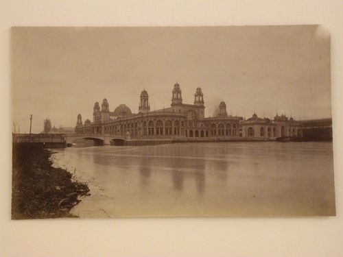
PH1981:0492
Description:
- This photograph shows a bridge connecting the Electricity Building to the Manufactures and Liberal Arts Building on the left and a bridge connecting the Electricity and Mines Buildings to the Wooded Island on the right, both across the Lagoon. The towers of the Machinery Building are under construction in the left background.
Personnes et institutions:
Sujet:
architecture
architecture
Date:
1892
1892
Titre:
View of the north and east façades of the Electricity Building from the east bank of the Lagoon with the Mines and Mining Building in the background, 1893 Chicago World's Columbian Exhibition, Chicago, Illinois
Actions:
PH1981:0492
Description:
- This photograph shows a bridge connecting the Electricity Building to the Manufactures and Liberal Arts Building on the left and a bridge connecting the Electricity and Mines Buildings to the Wooded Island on the right, both across the Lagoon. The towers of the Machinery Building are under construction in the left background.
Classification:
photographies
photographies
Date:
1892
1892
Personnes et institutions:
Sujet:
architecture
architecture
Classification:
photographies
photographies
Actions:
Numéro de référence:
PH1997:0065
PH1997:0065
Personnes et institutions:
Sujet:
architecture, topographique
architecture, topographique
Date:
1990
1990
Classification:
photographies
photographies
Date:
1990
1990
Personnes et institutions:
Sujet:
architecture, topographique
architecture, topographique