7175 Résultats
Niveau de description archivistique:
Projet
Projet
Numéro de référence:
AP194.S1.1995.PR01
Description:
Project records consist of records documenting the three phases of the Synthetic Landscape project (1995-2000) as worked on by Johan Bettum and OCEAN North. The project was initially developed and submitted in 1995 for the Membrane Design International Competition held in Japan by the Taiyo Kogyo Corporation. The entry showcases a children’s playscape in the setting of Oslo’s Tøyen Park, joining both its urban surroundings and its natural landscape into a synthetic space. Afterwards, the project was exhibited at the Architecture Association (AA) in London, where Johan Bettum and Kivi Sotamaa met. This eventually led to Bettum and Sotamaa collaborating on projects, along with their respective OCEAN teams in Oslo and Helsinki. The Synthetic Landscape project continued as a research project, with a second phase in 1996 and a third phase which ran from 1997 through 2000 and integrated design methods (particle streaming, Channelling Systems) from the work made on the Töölö and Jyväskylä projects. In the third phase, a pavilion was also added to the setting. Aside from one drawing, all records for this project are in a digital format. Drawings and models from phase 1 show parts or the whole of a shell-like structure. A color scheme seems to be associated to the different components of the structure. A report on phases 1 and 2 discusses the use of synthetic and composite materials for the structure, explaining the concept for the site. Phase 2 textual records include a working plan, site charts and program. Additional drawings and models show an evolution in the shape of the landscape. Most records are related to the third phase of Synthetic Landscape. They are largely drawings and models showing textures and coloured grafts used in the design process, section and surfaces studies, as well as site plans. Other files of the third phase consist of animated renderings of Channelling Systems studies within the Synthetic Landscape topology, saved as Quicktime MOV files. Additionally, the third phase of Synthetic Landscape has files related to the FEM (finite element method) analysis process utilized in the project’s engineering. This particular section includes raster images showing vectorial drawings and data appearing to be surface studies. These were likely created with the software Mathematica. The bulk of textual documentation on the project’s scope and outcomes may be found in AP194.S1.1995.PR01.001 for phases 1 and 2, and in AP194.S1.1995.PR01.005 for phase 3. The latter file also contains documentation related to a grant application to The Research Council of Norway; a proposal for a conference and exhibition at the AA; and administrative records such as budgets, correspondence, invoices, progress reports, meeting agendas and minutes. For all project phases, records related to the design process consist of CAD models saved in a variety of modelling formats (iges, fmz, dgn, 3dm, dxf) as well as raster or vector images (tiff, jpeg, png, eps, pict, etc.). In some cases, only these raster or vector images of the original CAD drawings are present in the archive.
Personnes et institutions:
Date:
1995-2000
1995-2000
Titre:
Synthetic Landscape research project, Oslo, Norway (1995-2000)
Actions:
AP194.S1.1995.PR01
Description:
Project records consist of records documenting the three phases of the Synthetic Landscape project (1995-2000) as worked on by Johan Bettum and OCEAN North. The project was initially developed and submitted in 1995 for the Membrane Design International Competition held in Japan by the Taiyo Kogyo Corporation. The entry showcases a children’s playscape in the setting of Oslo’s Tøyen Park, joining both its urban surroundings and its natural landscape into a synthetic space. Afterwards, the project was exhibited at the Architecture Association (AA) in London, where Johan Bettum and Kivi Sotamaa met. This eventually led to Bettum and Sotamaa collaborating on projects, along with their respective OCEAN teams in Oslo and Helsinki. The Synthetic Landscape project continued as a research project, with a second phase in 1996 and a third phase which ran from 1997 through 2000 and integrated design methods (particle streaming, Channelling Systems) from the work made on the Töölö and Jyväskylä projects. In the third phase, a pavilion was also added to the setting. Aside from one drawing, all records for this project are in a digital format. Drawings and models from phase 1 show parts or the whole of a shell-like structure. A color scheme seems to be associated to the different components of the structure. A report on phases 1 and 2 discusses the use of synthetic and composite materials for the structure, explaining the concept for the site. Phase 2 textual records include a working plan, site charts and program. Additional drawings and models show an evolution in the shape of the landscape. Most records are related to the third phase of Synthetic Landscape. They are largely drawings and models showing textures and coloured grafts used in the design process, section and surfaces studies, as well as site plans. Other files of the third phase consist of animated renderings of Channelling Systems studies within the Synthetic Landscape topology, saved as Quicktime MOV files. Additionally, the third phase of Synthetic Landscape has files related to the FEM (finite element method) analysis process utilized in the project’s engineering. This particular section includes raster images showing vectorial drawings and data appearing to be surface studies. These were likely created with the software Mathematica. The bulk of textual documentation on the project’s scope and outcomes may be found in AP194.S1.1995.PR01.001 for phases 1 and 2, and in AP194.S1.1995.PR01.005 for phase 3. The latter file also contains documentation related to a grant application to The Research Council of Norway; a proposal for a conference and exhibition at the AA; and administrative records such as budgets, correspondence, invoices, progress reports, meeting agendas and minutes. For all project phases, records related to the design process consist of CAD models saved in a variety of modelling formats (iges, fmz, dgn, 3dm, dxf) as well as raster or vector images (tiff, jpeg, png, eps, pict, etc.). In some cases, only these raster or vector images of the original CAD drawings are present in the archive.
Niveau de description archivistique:
Project
Project
Date:
1995-2000
1995-2000
Personnes et institutions:
Classification:
oeuvres d'art
oeuvres d'art
Actions:
Numéro de référence:
DR1987:0036
Description:
- A blueprint plan of the southern end of Anderson Park, New Jersey, bordering Mountain Avenue North. The plan, which shows only the road and park paths, is set against a numbered grid.
DR1987:0036
Description:
- A blueprint plan of the southern end of Anderson Park, New Jersey, bordering Mountain Avenue North. The plan, which shows only the road and park paths, is set against a numbered grid.
Personnes et institutions:
Sujet:
architecture de paysage
architecture de paysage
Date:
1912
1912
Titre:
Southern end of a proposed plan for Anderson Park, Essex County, New Jersey
Actions:
DR1987:0036
Description:
- A blueprint plan of the southern end of Anderson Park, New Jersey, bordering Mountain Avenue North. The plan, which shows only the road and park paths, is set against a numbered grid.
Southern end of a proposed plan for Anderson Park, Essex County, New Jersey
Actions:
DR1987:0036
Description:
- A blueprint plan of the southern end of Anderson Park, New Jersey, bordering Mountain Avenue North. The plan, which shows only the road and park paths, is set against a numbered grid.
Classification:
oeuvres d'art
oeuvres d'art
Date:
1912
1912
Personnes et institutions:
Sujet:
architecture de paysage
architecture de paysage
Classification:
photographies
photographies
Actions:
Numéro de référence:
PH1980:1220:072
Description:
- The photograph shows the tombs of Khawas Khan and Hazrat Abdul Razzaq Qadiri. The photographer was facing north-west. The tomb on the right of the photograph is that of Hazrat Abdul Razzaq Qadiri.
PH1980:1220:072
Description:
- The photograph shows the tombs of Khawas Khan and Hazrat Abdul Razzaq Qadiri. The photographer was facing north-west. The tomb on the right of the photograph is that of Hazrat Abdul Razzaq Qadiri.
Personnes et institutions:
Sujet:
architecture
architecture
Date:
March - April 1855
March - April 1855
Titre:
View of the Tomb of Khawas Khan on the left and the Tomb of Hazrat Abdul Razzak on the right, Beejapore (now Bijapur), India
Actions:
PH1980:1220:072
Description:
- The photograph shows the tombs of Khawas Khan and Hazrat Abdul Razzaq Qadiri. The photographer was facing north-west. The tomb on the right of the photograph is that of Hazrat Abdul Razzaq Qadiri.
Classification:
photographies
photographies
Date:
March - April 1855
March - April 1855
Personnes et institutions:
Sujet:
architecture
architecture
Classification:
photographies
photographies
Numéro de référence:
ARCH276589
Description:
Binder contains presentation slides for projects filed under, "Mixed Use." Includes: California Plaza, Midtown Terrace, Hornby-Smythe Development, Harborplace Square, Market Square, Geffen Building, Triad Park, Winston-Salem, North Carolina.
ARCH276589
Description:
Binder contains presentation slides for projects filed under, "Mixed Use." Includes: California Plaza, Midtown Terrace, Hornby-Smythe Development, Harborplace Square, Market Square, Geffen Building, Triad Park, Winston-Salem, North Carolina.
Personnes et institutions:
Date:
1975-1984
1975-1984
Titre:
Presentation slides for various projects
Actions:
ARCH276589
Description:
Binder contains presentation slides for projects filed under, "Mixed Use." Includes: California Plaza, Midtown Terrace, Hornby-Smythe Development, Harborplace Square, Market Square, Geffen Building, Triad Park, Winston-Salem, North Carolina.
Classification:
photographies
photographies
Date:
1975-1984
1975-1984
Personnes et institutions:
Classification:
documents textuels
documents textuels
Titre:
South Indian Lake
South Indian Lake
Numéro de référence:
ARCH253562
Description:
This file contains harmful material and uses racist language. original copy of Transition in the North report, unbound; clippings, memorandum on the immediate and long-term needs of native people of Northern Manitoba
ARCH253562
Description:
This file contains harmful material and uses racist language. original copy of Transition in the North report, unbound; clippings, memorandum on the immediate and long-term needs of native people of Northern Manitoba
Personnes et institutions:
Date:
1967-1968
1967-1968
Titre:
South Indian Lake
Actions:
ARCH253562
Description:
This file contains harmful material and uses racist language. original copy of Transition in the North report, unbound; clippings, memorandum on the immediate and long-term needs of native people of Northern Manitoba
South Indian Lake
Actions:
ARCH253562
Description:
This file contains harmful material and uses racist language. original copy of Transition in the North report, unbound; clippings, memorandum on the immediate and long-term needs of native people of Northern Manitoba
Classification:
documents textuels
documents textuels
Date:
1967-1968
1967-1968
Personnes et institutions:
Classification:
dessins
Quantité:
4 File
dessins
Quantité:
4 File
Numéro de référence:
ARCH254966
Description:
quadrangle building - preliminary lower floor plan and department offices plan, upper floor plan and depatmentment offeces plans, section thru central mall phase two, typical isometrics of court elevation and north elevation
ARCH254966
Description:
quadrangle building - preliminary lower floor plan and department offices plan, upper floor plan and depatmentment offeces plans, section thru central mall phase two, typical isometrics of court elevation and north elevation
Personnes et institutions:
Date:
1963
1963
Titre:
Quadrangle building - preliminary lower floor plan and department offices plan
Actions:
ARCH254966
Description:
quadrangle building - preliminary lower floor plan and department offices plan, upper floor plan and depatmentment offeces plans, section thru central mall phase two, typical isometrics of court elevation and north elevation
Classification:
dessins
Quantité:
4 File
dessins
Quantité:
4 File
Date:
1963
1963
Personnes et institutions:
Classification:
dessins
Quantité:
3 publication drawing(s)
dessins
Quantité:
3 publication drawing(s)
Numéro de référence:
AP140.S2.SS1.D31.P5
Description:
hand-coloured diagrammatic plan for the breakfast room level showing the axis determining the position of the ventilator/weathervane, a hand-coloured worm's-eye plan oblique, and a perspective from the north-west
AP140.S2.SS1.D31.P5
Description:
hand-coloured diagrammatic plan for the breakfast room level showing the axis determining the position of the ventilator/weathervane, a hand-coloured worm's-eye plan oblique, and a perspective from the north-west
Personnes et institutions:
Titre:
Hand-coloured diagrammatic plan for the breakfast room level
Actions:
AP140.S2.SS1.D31.P5
Description:
hand-coloured diagrammatic plan for the breakfast room level showing the axis determining the position of the ventilator/weathervane, a hand-coloured worm's-eye plan oblique, and a perspective from the north-west
Classification:
dessins
Quantité:
3 publication drawing(s)
dessins
Quantité:
3 publication drawing(s)
Personnes et institutions:
Classification:
dessins
Quantité:
7 File
dessins
Quantité:
7 File
Numéro de référence:
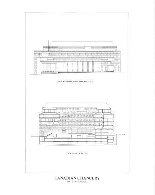
ARCH78912
Description:
bird's-eye axonometric projections of the site, site plan, north-south section and John Marshall Place Park elevation, east-west section and Pennsylvania Avenue elevation, podium level plan, executive office level plan
ARCH78912
Description:
bird's-eye axonometric projections of the site, site plan, north-south section and John Marshall Place Park elevation, east-west section and Pennsylvania Avenue elevation, podium level plan, executive office level plan
Personnes et institutions:
Date:
circa 1947-2002
circa 1947-2002
Titre:
Bird's-eye axonometric projections of the site, site plan
Actions:
ARCH78912
Description:
bird's-eye axonometric projections of the site, site plan, north-south section and John Marshall Place Park elevation, east-west section and Pennsylvania Avenue elevation, podium level plan, executive office level plan
Classification:
dessins
Quantité:
7 File
dessins
Quantité:
7 File
Date:
circa 1947-2002
circa 1947-2002
Personnes et institutions:
Classification:
documents textuels
documents textuels
Numéro de référence:
ARCH257223
Description:
"Permanent Files" - Lake Superior Centre, University of North Carolina Master Plan (Greensboro), University of British Columbia New Library Project, New Federal Court of Canada Building (Ottawa), Bayshore Gardens zoning admendment, Coal Harboor Arts Complex, Port Moody City Hall Library and Theatre Building, Furry Creek Development Project, Emily Carr College of Art and Design, Greater Victoria Hospital Diagnostic Treatment Facilities, Vancouver Dance Centre, University of British Columbia Performing Arts Facility, DCAD North Terminal Expansion (Miami)
Personnes et institutions:
Date:
1990-1991
1990-1991
Titre:
Permanent Files for various projects
Actions:
ARCH257223
Description:
"Permanent Files" - Lake Superior Centre, University of North Carolina Master Plan (Greensboro), University of British Columbia New Library Project, New Federal Court of Canada Building (Ottawa), Bayshore Gardens zoning admendment, Coal Harboor Arts Complex, Port Moody City Hall Library and Theatre Building, Furry Creek Development Project, Emily Carr College of Art and Design, Greater Victoria Hospital Diagnostic Treatment Facilities, Vancouver Dance Centre, University of British Columbia Performing Arts Facility, DCAD North Terminal Expansion (Miami)
Classification:
documents textuels
documents textuels
Date:
1990-1991
1990-1991
Personnes et institutions:
Classification:
photographies
photographies
Actions:
Numéro de référence:
PH1980:1220:061
Description:
- The photograph shows a group of tombs in an enclosure. In the distance on the right is the dome of the tomb of the Qadiri brothers, Pir Hamid and Pir Latifullah. The photographer is facing north-west.
PH1980:1220:061
Description:
- The photograph shows a group of tombs in an enclosure. In the distance on the right is the dome of the tomb of the Qadiri brothers, Pir Hamid and Pir Latifullah. The photographer is facing north-west.
Personnes et institutions:
Sujet:
architecture
architecture
Date:
March - April 1855
March - April 1855
Titre:
View of tombs with the dome of the Mausoleum of the Qadiri Brothers on the far right, Beejapore (now Bijapur), India
Actions:
PH1980:1220:061
Description:
- The photograph shows a group of tombs in an enclosure. In the distance on the right is the dome of the tomb of the Qadiri brothers, Pir Hamid and Pir Latifullah. The photographer is facing north-west.
Classification:
photographies
photographies
Date:
March - April 1855
March - April 1855
Personnes et institutions:
Sujet:
architecture
architecture