


9541 Résultats
Classification:
photographies
photographies
Numéro de référence:
AP140.S2.SS7.D2.P7
Description:
views of various projects by the successive firms of Stirling and Gowan, James Stirling and James Stirling and Partner, including Flats at Ham Common, School Assembly Hall, Brunswick Park Primary School, Dorman Long Headquarters, Florey Building, Queen's College, University of Oxford and British Olivetti Headquarters in Milton Keynes, also views of Liverpool, of the Maison de verre in Paris by architect Pierre Charreau, the Alton Estate in Roehampton, the Atomium at the 1958 Exposition universelle et internationale in Brussels, Keeling House in London by architect Denys Lasdun, buildings by architect Antoni Gaudí, projects by Le Corbusier for lectures by James Stirling, of travels in the United States, including San Francisco, also includes a few negatives
AP140.S2.SS7.D2.P7
Description:
views of various projects by the successive firms of Stirling and Gowan, James Stirling and James Stirling and Partner, including Flats at Ham Common, School Assembly Hall, Brunswick Park Primary School, Dorman Long Headquarters, Florey Building, Queen's College, University of Oxford and British Olivetti Headquarters in Milton Keynes, also views of Liverpool, of the Maison de verre in Paris by architect Pierre Charreau, the Alton Estate in Roehampton, the Atomium at the 1958 Exposition universelle et internationale in Brussels, Keeling House in London by architect Denys Lasdun, buildings by architect Antoni Gaudí, projects by Le Corbusier for lectures by James Stirling, of travels in the United States, including San Francisco, also includes a few negatives
Personnes et institutions:
Titre:
Views of various projects by the successive firms of Stirling and Gowan, James Stirling and James Stirling and Partner
Actions:
AP140.S2.SS7.D2.P7
Description:
views of various projects by the successive firms of Stirling and Gowan, James Stirling and James Stirling and Partner, including Flats at Ham Common, School Assembly Hall, Brunswick Park Primary School, Dorman Long Headquarters, Florey Building, Queen's College, University of Oxford and British Olivetti Headquarters in Milton Keynes, also views of Liverpool, of the Maison de verre in Paris by architect Pierre Charreau, the Alton Estate in Roehampton, the Atomium at the 1958 Exposition universelle et internationale in Brussels, Keeling House in London by architect Denys Lasdun, buildings by architect Antoni Gaudí, projects by Le Corbusier for lectures by James Stirling, of travels in the United States, including San Francisco, also includes a few negatives
Views of various projects by the successive firms of Stirling and Gowan, James Stirling and James Stirling and Partner
Actions:
AP140.S2.SS7.D2.P7
Description:
views of various projects by the successive firms of Stirling and Gowan, James Stirling and James Stirling and Partner, including Flats at Ham Common, School Assembly Hall, Brunswick Park Primary School, Dorman Long Headquarters, Florey Building, Queen's College, University of Oxford and British Olivetti Headquarters in Milton Keynes, also views of Liverpool, of the Maison de verre in Paris by architect Pierre Charreau, the Alton Estate in Roehampton, the Atomium at the 1958 Exposition universelle et internationale in Brussels, Keeling House in London by architect Denys Lasdun, buildings by architect Antoni Gaudí, projects by Le Corbusier for lectures by James Stirling, of travels in the United States, including San Francisco, also includes a few negatives
Classification:
photographies
photographies
Personnes et institutions:
Classification:
dessins
dessins
Numéro de référence:
ARCH261268
Description:
Sets of sections, elevations, floor and level plans with revisions and annotations. Including reduced schematic drawings and site plans, and two plans or original site and landscape plan (Bureau of Parks and Recreation, Portland, 1958).
ARCH261268
Description:
Sets of sections, elevations, floor and level plans with revisions and annotations. Including reduced schematic drawings and site plans, and two plans or original site and landscape plan (Bureau of Parks and Recreation, Portland, 1958).
Personnes et institutions:
Date:
1980
1980
Titre:
Sets of sections, elevations, floor and level plans with revisions and annotations
Actions:
ARCH261268
Description:
Sets of sections, elevations, floor and level plans with revisions and annotations. Including reduced schematic drawings and site plans, and two plans or original site and landscape plan (Bureau of Parks and Recreation, Portland, 1958).
Sets of sections, elevations, floor and level plans with revisions and annotations
Actions:
ARCH261268
Description:
Sets of sections, elevations, floor and level plans with revisions and annotations. Including reduced schematic drawings and site plans, and two plans or original site and landscape plan (Bureau of Parks and Recreation, Portland, 1958).
Classification:
dessins
dessins
Date:
1980
1980
Personnes et institutions:
Classification:
documents textuels
documents textuels
Numéro de référence:
DR2012:0012:085:026
Description:
File containing documents in English, including correspondence, notes, waybills, writing drafts, and photocopies of floor plans for the Israel Museum with annotations in graphite, related to the exhibition, Displacements: the work of Melvin Charney. The exhibition included the following artworks: - Un dictionnaire .... illuminations; - The site, les maisons; - The site altered, les maisons de la rue; - Les maisons de la rue Sherbrooke; - Parable series ... clenched fists, greased palms; - Parable series ... with help, gasoline; - Parable no. 22 ... Battery Park City finally starts, New York; - Parable no. 25 ... re: visions of the temple; - The white city revisited ... Tel Aviv; - Origins of the white city ... no. 3, Paris. Original folder inscribed in graphite: ISRAEL MUSEUM / CAT TEXTS 1994-95
DR2012:0012:085:026
Description:
File containing documents in English, including correspondence, notes, waybills, writing drafts, and photocopies of floor plans for the Israel Museum with annotations in graphite, related to the exhibition, Displacements: the work of Melvin Charney. The exhibition included the following artworks: - Un dictionnaire .... illuminations; - The site, les maisons; - The site altered, les maisons de la rue; - Les maisons de la rue Sherbrooke; - Parable series ... clenched fists, greased palms; - Parable series ... with help, gasoline; - Parable no. 22 ... Battery Park City finally starts, New York; - Parable no. 25 ... re: visions of the temple; - The white city revisited ... Tel Aviv; - Origins of the white city ... no. 3, Paris. Original folder inscribed in graphite: ISRAEL MUSEUM / CAT TEXTS 1994-95
Personnes et institutions:
Date:
1995-1996
1995-1996
Titre:
Correspondence, notes, waybills, writing drafts, and photocopies of floor plans related to exhibition "Displacements: the work of Melvin Charney"
Actions:
DR2012:0012:085:026
Description:
File containing documents in English, including correspondence, notes, waybills, writing drafts, and photocopies of floor plans for the Israel Museum with annotations in graphite, related to the exhibition, Displacements: the work of Melvin Charney. The exhibition included the following artworks: - Un dictionnaire .... illuminations; - The site, les maisons; - The site altered, les maisons de la rue; - Les maisons de la rue Sherbrooke; - Parable series ... clenched fists, greased palms; - Parable series ... with help, gasoline; - Parable no. 22 ... Battery Park City finally starts, New York; - Parable no. 25 ... re: visions of the temple; - The white city revisited ... Tel Aviv; - Origins of the white city ... no. 3, Paris. Original folder inscribed in graphite: ISRAEL MUSEUM / CAT TEXTS 1994-95
Correspondence, notes, waybills, writing drafts, and photocopies of floor plans related to exhibition "Displacements: the work of Melvin Charney"
Actions:
DR2012:0012:085:026
Description:
File containing documents in English, including correspondence, notes, waybills, writing drafts, and photocopies of floor plans for the Israel Museum with annotations in graphite, related to the exhibition, Displacements: the work of Melvin Charney. The exhibition included the following artworks: - Un dictionnaire .... illuminations; - The site, les maisons; - The site altered, les maisons de la rue; - Les maisons de la rue Sherbrooke; - Parable series ... clenched fists, greased palms; - Parable series ... with help, gasoline; - Parable no. 22 ... Battery Park City finally starts, New York; - Parable no. 25 ... re: visions of the temple; - The white city revisited ... Tel Aviv; - Origins of the white city ... no. 3, Paris. Original folder inscribed in graphite: ISRAEL MUSEUM / CAT TEXTS 1994-95
Classification:
documents textuels
documents textuels
Date:
1995-1996
1995-1996
Personnes et institutions:
Classification:
événements
événements
Actions:
Description:
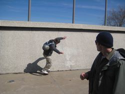
Le planchiste et architecte-paysagiste Mathieu Robichaud invite les participants à une visite guidée et analyse les opportunités qu’offrent les espaces urbains traversés pour la pratique de la planche à roulettes. Robichaud, de la firme Bloom Paysage, se spécialise dans la conception de parcs dédiés à la pratique de la planche à roulettes. En complément de l’exposition(...)
Le planchiste et architecte-paysagiste Mathieu Robichaud invite les participants à une visite guidée et analyse les opportunités qu’offrent les espaces urbains traversés pour la pratique de la planche à roulettes. Robichaud, de la firme Bloom Paysage, se spécialise dans la conception de parcs dédiés à la pratique de la planche à roulettes. En complément de l’exposition(...)
Date:
11 avril 2009
11 avril 2009
Titre:
Découvrir les lieux propices à la pratique de la planche à roulettes
Actions:
Description:
Le planchiste et architecte-paysagiste Mathieu Robichaud invite les participants à une visite guidée et analyse les opportunités qu’offrent les espaces urbains traversés pour la pratique de la planche à roulettes. Robichaud, de la firme Bloom Paysage, se spécialise dans la conception de parcs dédiés à la pratique de la planche à roulettes. En complément de l’exposition(...)
Découvrir les lieux propices à la pratique de la planche à roulettes
Actions:
Description:
Le planchiste et architecte-paysagiste Mathieu Robichaud invite les participants à une visite guidée et analyse les opportunités qu’offrent les espaces urbains traversés pour la pratique de la planche à roulettes. Robichaud, de la firme Bloom Paysage, se spécialise dans la conception de parcs dédiés à la pratique de la planche à roulettes. En complément de l’exposition(...)
Classification:
événements
événements
Date:
11 avril 2009
11 avril 2009
Classification:
archives
Niveau de description archivistique:
Fonds
archives
Niveau de description archivistique:
Fonds
Titre:
Fonds Gene Summers
Fonds Gene Summers
Numéro de référence:
AP114
Résumé:
The Gene Summers fonds documents primarily the later part of Gene Summers' career as an architect, developer, artist and art collector. Summer's early work with the Office of Mies van der Rohe and C.F. Murphy Associates is summarily represented by notes, sketches and photographs.
AP114
Résumé:
The Gene Summers fonds documents primarily the later part of Gene Summers' career as an architect, developer, artist and art collector. Summer's early work with the Office of Mies van der Rohe and C.F. Murphy Associates is summarily represented by notes, sketches and photographs.
Personnes et institutions:
Date:
1957 - 2004
1957 - 2004
Titre:
Fonds Gene Summers
Actions:
AP114
Résumé:
The Gene Summers fonds documents primarily the later part of Gene Summers' career as an architect, developer, artist and art collector. Summer's early work with the Office of Mies van der Rohe and C.F. Murphy Associates is summarily represented by notes, sketches and photographs.
Fonds Gene Summers
Actions:
AP114
Résumé:
The Gene Summers fonds documents primarily the later part of Gene Summers' career as an architect, developer, artist and art collector. Summer's early work with the Office of Mies van der Rohe and C.F. Murphy Associates is summarily represented by notes, sketches and photographs.
Classification:
archives
Niveau de description archivistique:
Fonds
archives
Niveau de description archivistique:
Fonds
Date:
1957 - 2004
1957 - 2004
Personnes et institutions:
Niveau de description archivistique:
Projet
Projet
Numéro de référence:
AP075.S1.1974.PR01
Description:
Project series documents Cornelia Hahn Oberlander's project for the landscape of Robson Square Provincial Government Complex in Vancouver, British Columbia. Oberlander worked on this project in 1974-1982 with architect Arthur Erickson and architect Bing Thom. The project consisted in designing a new provincial civic complex that included a courthouse and provincial government offices. The initial plan consisted in a 55-storey highrise. Arthur Erickson suggested to lay the building on its side and spread it accross three city blocks (known as Block 51, Block 61 and Block 71) and add a green roof to create linear park. Oberlander's ideas for the landscape concept was to create a space accessible for everyone that will be attractive and interesting in all seasons. Her design consisted in a series of pathways, stairs and terraces, mainly situated on Block 61, and rising gradually up to 30 feets above the Robson street level. The design was intented to "encourage pedestrians to cut accross the urban grid". [1] Planters where included to buildings facades to create a hanging garden using hanging plants. The project series contains design development drawings and working drawings for the landscape design, such as landscape plans, landscape sections, elevations and details, grading and irrigation plans, and planting plans. The drawings includes in this project series also comprises plans of the complex buildings used as reference. The majority of the drawings are reprographic copies. The series also comprises five original sketches by Oberlander. The project is also documented through interior and exterior photographs of the building, photographs of the landscape and various views of the completed complex. The project series also includes textual records, including documents related to the plants selection, specifications, financial documents, concept development notes of Oberlander, correspondence with architects, clients and consultants, documentation and research material, and clippings and articles on Robson Square project. Source: [1] Herrington, Susan. Cornelia Hahn Oberlander: Making the Modern Landscape, University of Virginia Press, 2014, 304 pages. p. 123.
AP075.S1.1974.PR01
Description:
Project series documents Cornelia Hahn Oberlander's project for the landscape of Robson Square Provincial Government Complex in Vancouver, British Columbia. Oberlander worked on this project in 1974-1982 with architect Arthur Erickson and architect Bing Thom. The project consisted in designing a new provincial civic complex that included a courthouse and provincial government offices. The initial plan consisted in a 55-storey highrise. Arthur Erickson suggested to lay the building on its side and spread it accross three city blocks (known as Block 51, Block 61 and Block 71) and add a green roof to create linear park. Oberlander's ideas for the landscape concept was to create a space accessible for everyone that will be attractive and interesting in all seasons. Her design consisted in a series of pathways, stairs and terraces, mainly situated on Block 61, and rising gradually up to 30 feets above the Robson street level. The design was intented to "encourage pedestrians to cut accross the urban grid". [1] Planters where included to buildings facades to create a hanging garden using hanging plants. The project series contains design development drawings and working drawings for the landscape design, such as landscape plans, landscape sections, elevations and details, grading and irrigation plans, and planting plans. The drawings includes in this project series also comprises plans of the complex buildings used as reference. The majority of the drawings are reprographic copies. The series also comprises five original sketches by Oberlander. The project is also documented through interior and exterior photographs of the building, photographs of the landscape and various views of the completed complex. The project series also includes textual records, including documents related to the plants selection, specifications, financial documents, concept development notes of Oberlander, correspondence with architects, clients and consultants, documentation and research material, and clippings and articles on Robson Square project. Source: [1] Herrington, Susan. Cornelia Hahn Oberlander: Making the Modern Landscape, University of Virginia Press, 2014, 304 pages. p. 123.
Personnes et institutions:
Date:
1970-1995
1970-1995
Titre:
Robson Square Provincial Government Complex, Vancouver, British Columbia (1974-1982)
Actions:
AP075.S1.1974.PR01
Description:
Project series documents Cornelia Hahn Oberlander's project for the landscape of Robson Square Provincial Government Complex in Vancouver, British Columbia. Oberlander worked on this project in 1974-1982 with architect Arthur Erickson and architect Bing Thom. The project consisted in designing a new provincial civic complex that included a courthouse and provincial government offices. The initial plan consisted in a 55-storey highrise. Arthur Erickson suggested to lay the building on its side and spread it accross three city blocks (known as Block 51, Block 61 and Block 71) and add a green roof to create linear park. Oberlander's ideas for the landscape concept was to create a space accessible for everyone that will be attractive and interesting in all seasons. Her design consisted in a series of pathways, stairs and terraces, mainly situated on Block 61, and rising gradually up to 30 feets above the Robson street level. The design was intented to "encourage pedestrians to cut accross the urban grid". [1] Planters where included to buildings facades to create a hanging garden using hanging plants. The project series contains design development drawings and working drawings for the landscape design, such as landscape plans, landscape sections, elevations and details, grading and irrigation plans, and planting plans. The drawings includes in this project series also comprises plans of the complex buildings used as reference. The majority of the drawings are reprographic copies. The series also comprises five original sketches by Oberlander. The project is also documented through interior and exterior photographs of the building, photographs of the landscape and various views of the completed complex. The project series also includes textual records, including documents related to the plants selection, specifications, financial documents, concept development notes of Oberlander, correspondence with architects, clients and consultants, documentation and research material, and clippings and articles on Robson Square project. Source: [1] Herrington, Susan. Cornelia Hahn Oberlander: Making the Modern Landscape, University of Virginia Press, 2014, 304 pages. p. 123.
Robson Square Provincial Government Complex, Vancouver, British Columbia (1974-1982)
Actions:
AP075.S1.1974.PR01
Description:
Project series documents Cornelia Hahn Oberlander's project for the landscape of Robson Square Provincial Government Complex in Vancouver, British Columbia. Oberlander worked on this project in 1974-1982 with architect Arthur Erickson and architect Bing Thom. The project consisted in designing a new provincial civic complex that included a courthouse and provincial government offices. The initial plan consisted in a 55-storey highrise. Arthur Erickson suggested to lay the building on its side and spread it accross three city blocks (known as Block 51, Block 61 and Block 71) and add a green roof to create linear park. Oberlander's ideas for the landscape concept was to create a space accessible for everyone that will be attractive and interesting in all seasons. Her design consisted in a series of pathways, stairs and terraces, mainly situated on Block 61, and rising gradually up to 30 feets above the Robson street level. The design was intented to "encourage pedestrians to cut accross the urban grid". [1] Planters where included to buildings facades to create a hanging garden using hanging plants. The project series contains design development drawings and working drawings for the landscape design, such as landscape plans, landscape sections, elevations and details, grading and irrigation plans, and planting plans. The drawings includes in this project series also comprises plans of the complex buildings used as reference. The majority of the drawings are reprographic copies. The series also comprises five original sketches by Oberlander. The project is also documented through interior and exterior photographs of the building, photographs of the landscape and various views of the completed complex. The project series also includes textual records, including documents related to the plants selection, specifications, financial documents, concept development notes of Oberlander, correspondence with architects, clients and consultants, documentation and research material, and clippings and articles on Robson Square project. Source: [1] Herrington, Susan. Cornelia Hahn Oberlander: Making the Modern Landscape, University of Virginia Press, 2014, 304 pages. p. 123.
Niveau de description archivistique:
Project
Project
Date:
1970-1995
1970-1995
Personnes et institutions:
Niveau de description archivistique:
Projet
Projet
Numéro de référence:
AP178.S1.2002.PR05
Description:
This project series documents the Parque de Vidago in Vidago, Portugal. While the records were held in the office’s archives this project was assigned the number 49/00. The office assigned the dates 2002-2010 to this project. This project consisted of extensive modifications to the spa resort Parque de Vidago Palace Hotel for owner VMPS - Águas & Turismo, S.A, part of Unicer (now Super Bock Group). The Palace Hotel and its surrounding nature park were originally proposed by King Carlos I at the beginning of the 20th century in order to create a luxurious resort around the famous Vidago mineral springs. In 2006, the resort was temporarily closed for the work to begin. For Siza, this primarily consisted of the construction of a new thermal spa, the conversion of rural buildings into vacation homes, and the building of a new clubhouse for the golf course. These three aspects of the project were divided as three subprojects by the office and have been arranged under AP178.S1.2002.PR05.SS1, AP178.S1.2002.PR05.SS2 and AP178.S1.2002.PR05.SS3, respectively. While the spa and clubhouse were both built, the vacation homes were not realized. The resort reopened in 2010. Several smaller buildings were also realized as part of this project including the Fonte Salus (spring), the Fonte de Vidago (spring) and the Portaria (gatehouse). Materials for these three building are arranged in AP178.S1.2002.PR05.SS1. Also included were several buildings that were not realized such as the Academia de golfe and the Edifício da manutenção (arranged in AP178.S1.2002.PR05.SS3), and the Espaço Serralves (arranged in AP178.S1.2002.PR05.SS1). This project was realized in tandem with another similar project by Siza, the Parque de Pedras Salgadas (AP178.S1.2002.PR06), also owned by Unicer. For this reason, the materials for both projects are mixed together. Files in this project series that contain materials for the Pedras Salgadas project have been identified at the file level.
AP178.S1.2002.PR05
Description:
This project series documents the Parque de Vidago in Vidago, Portugal. While the records were held in the office’s archives this project was assigned the number 49/00. The office assigned the dates 2002-2010 to this project. This project consisted of extensive modifications to the spa resort Parque de Vidago Palace Hotel for owner VMPS - Águas & Turismo, S.A, part of Unicer (now Super Bock Group). The Palace Hotel and its surrounding nature park were originally proposed by King Carlos I at the beginning of the 20th century in order to create a luxurious resort around the famous Vidago mineral springs. In 2006, the resort was temporarily closed for the work to begin. For Siza, this primarily consisted of the construction of a new thermal spa, the conversion of rural buildings into vacation homes, and the building of a new clubhouse for the golf course. These three aspects of the project were divided as three subprojects by the office and have been arranged under AP178.S1.2002.PR05.SS1, AP178.S1.2002.PR05.SS2 and AP178.S1.2002.PR05.SS3, respectively. While the spa and clubhouse were both built, the vacation homes were not realized. The resort reopened in 2010. Several smaller buildings were also realized as part of this project including the Fonte Salus (spring), the Fonte de Vidago (spring) and the Portaria (gatehouse). Materials for these three building are arranged in AP178.S1.2002.PR05.SS1. Also included were several buildings that were not realized such as the Academia de golfe and the Edifício da manutenção (arranged in AP178.S1.2002.PR05.SS3), and the Espaço Serralves (arranged in AP178.S1.2002.PR05.SS1). This project was realized in tandem with another similar project by Siza, the Parque de Pedras Salgadas (AP178.S1.2002.PR06), also owned by Unicer. For this reason, the materials for both projects are mixed together. Files in this project series that contain materials for the Pedras Salgadas project have been identified at the file level.
Personnes et institutions:
Date:
2002-2012
2002-2012
Titre:
Parque de Vidago [Vidago Palace], Vidago, Portugal (2002-2010)
Actions:
AP178.S1.2002.PR05
Description:
This project series documents the Parque de Vidago in Vidago, Portugal. While the records were held in the office’s archives this project was assigned the number 49/00. The office assigned the dates 2002-2010 to this project. This project consisted of extensive modifications to the spa resort Parque de Vidago Palace Hotel for owner VMPS - Águas & Turismo, S.A, part of Unicer (now Super Bock Group). The Palace Hotel and its surrounding nature park were originally proposed by King Carlos I at the beginning of the 20th century in order to create a luxurious resort around the famous Vidago mineral springs. In 2006, the resort was temporarily closed for the work to begin. For Siza, this primarily consisted of the construction of a new thermal spa, the conversion of rural buildings into vacation homes, and the building of a new clubhouse for the golf course. These three aspects of the project were divided as three subprojects by the office and have been arranged under AP178.S1.2002.PR05.SS1, AP178.S1.2002.PR05.SS2 and AP178.S1.2002.PR05.SS3, respectively. While the spa and clubhouse were both built, the vacation homes were not realized. The resort reopened in 2010. Several smaller buildings were also realized as part of this project including the Fonte Salus (spring), the Fonte de Vidago (spring) and the Portaria (gatehouse). Materials for these three building are arranged in AP178.S1.2002.PR05.SS1. Also included were several buildings that were not realized such as the Academia de golfe and the Edifício da manutenção (arranged in AP178.S1.2002.PR05.SS3), and the Espaço Serralves (arranged in AP178.S1.2002.PR05.SS1). This project was realized in tandem with another similar project by Siza, the Parque de Pedras Salgadas (AP178.S1.2002.PR06), also owned by Unicer. For this reason, the materials for both projects are mixed together. Files in this project series that contain materials for the Pedras Salgadas project have been identified at the file level.
Parque de Vidago [Vidago Palace], Vidago, Portugal (2002-2010)
Actions:
AP178.S1.2002.PR05
Description:
This project series documents the Parque de Vidago in Vidago, Portugal. While the records were held in the office’s archives this project was assigned the number 49/00. The office assigned the dates 2002-2010 to this project. This project consisted of extensive modifications to the spa resort Parque de Vidago Palace Hotel for owner VMPS - Águas & Turismo, S.A, part of Unicer (now Super Bock Group). The Palace Hotel and its surrounding nature park were originally proposed by King Carlos I at the beginning of the 20th century in order to create a luxurious resort around the famous Vidago mineral springs. In 2006, the resort was temporarily closed for the work to begin. For Siza, this primarily consisted of the construction of a new thermal spa, the conversion of rural buildings into vacation homes, and the building of a new clubhouse for the golf course. These three aspects of the project were divided as three subprojects by the office and have been arranged under AP178.S1.2002.PR05.SS1, AP178.S1.2002.PR05.SS2 and AP178.S1.2002.PR05.SS3, respectively. While the spa and clubhouse were both built, the vacation homes were not realized. The resort reopened in 2010. Several smaller buildings were also realized as part of this project including the Fonte Salus (spring), the Fonte de Vidago (spring) and the Portaria (gatehouse). Materials for these three building are arranged in AP178.S1.2002.PR05.SS1. Also included were several buildings that were not realized such as the Academia de golfe and the Edifício da manutenção (arranged in AP178.S1.2002.PR05.SS3), and the Espaço Serralves (arranged in AP178.S1.2002.PR05.SS1). This project was realized in tandem with another similar project by Siza, the Parque de Pedras Salgadas (AP178.S1.2002.PR06), also owned by Unicer. For this reason, the materials for both projects are mixed together. Files in this project series that contain materials for the Pedras Salgadas project have been identified at the file level.
Niveau de description archivistique:
Project
Project
Date:
2002-2012
2002-2012
Personnes et institutions:
Classification:
événements
événements
Titre:
Gilles Clément
Gilles Clément
Actions:
Description:
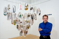
Dans le cadre de l’exposition Environnement : manières d’agir pour demain (2006), l’ingénieur horticole et paysagiste français Gilles Clément présente ses projets et ses théories. L’exposition propose un changement de perspective où l’environnement devient le point de départ d’une réflexion et non nos exigences d’humains envers ce dernier. Gilles Clément a réalisé de(...)
Dans le cadre de l’exposition Environnement : manières d’agir pour demain (2006), l’ingénieur horticole et paysagiste français Gilles Clément présente ses projets et ses théories. L’exposition propose un changement de perspective où l’environnement devient le point de départ d’une réflexion et non nos exigences d’humains envers ce dernier. Gilles Clément a réalisé de(...)
Localisation:
Théâtre Paul-Desmarais
Théâtre Paul-Desmarais
Date:
19 octobre 2006
19 octobre 2006
Titre:
Gilles Clément
Actions:
Description:
Dans le cadre de l’exposition Environnement : manières d’agir pour demain (2006), l’ingénieur horticole et paysagiste français Gilles Clément présente ses projets et ses théories. L’exposition propose un changement de perspective où l’environnement devient le point de départ d’une réflexion et non nos exigences d’humains envers ce dernier. Gilles Clément a réalisé de(...)
Gilles Clément
Actions:
Description:
Dans le cadre de l’exposition Environnement : manières d’agir pour demain (2006), l’ingénieur horticole et paysagiste français Gilles Clément présente ses projets et ses théories. L’exposition propose un changement de perspective où l’environnement devient le point de départ d’une réflexion et non nos exigences d’humains envers ce dernier. Gilles Clément a réalisé de(...)
Classification:
événements
événements
Date:
19 octobre 2006
19 octobre 2006
Localisation:
Théâtre Paul-Desmarais
Théâtre Paul-Desmarais
Classification:
expositions
expositions
Actions:
Description:
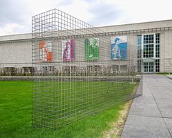
Mur absent : Évocation du Garbage Wall (1970) de Gordon Matta-Clark, une installation dans Parc Baile, est une structure symbolique qui évoque l’intérêt porté par Matta-Clark au recyclage, aux espaces abandonnés et à une vision différente de la conception architecturale. À l’occasion du premier Jour de la Terre, Gordon Matta-Clark (1943-78) organise un événement à(...)
Mur absent : Évocation du Garbage Wall (1970) de Gordon Matta-Clark, une installation dans Parc Baile, est une structure symbolique qui évoque l’intérêt porté par Matta-Clark au recyclage, aux espaces abandonnés et à une vision différente de la conception architecturale. À l’occasion du premier Jour de la Terre, Gordon Matta-Clark (1943-78) organise un événement à(...)
Localisation:
Parc Baile
Parc Baile
Date:
6 mai 2004 au 6 septembre 2004
6 mai 2004 au 6 septembre 2004
Titre:
Mur absent : évocation du Garbage Wall (1970) de Gordon Matta-Clark
Actions:
Description:
Mur absent : Évocation du Garbage Wall (1970) de Gordon Matta-Clark, une installation dans Parc Baile, est une structure symbolique qui évoque l’intérêt porté par Matta-Clark au recyclage, aux espaces abandonnés et à une vision différente de la conception architecturale. À l’occasion du premier Jour de la Terre, Gordon Matta-Clark (1943-78) organise un événement à(...)
Mur absent : évocation du Garbage Wall (1970) de Gordon Matta-Clark
Actions:
Description:
Mur absent : Évocation du Garbage Wall (1970) de Gordon Matta-Clark, une installation dans Parc Baile, est une structure symbolique qui évoque l’intérêt porté par Matta-Clark au recyclage, aux espaces abandonnés et à une vision différente de la conception architecturale. À l’occasion du premier Jour de la Terre, Gordon Matta-Clark (1943-78) organise un événement à(...)
Classification:
expositions
expositions
Date:
6 mai 2004 au
6 septembre 2004
6 mai 2004 au
6 septembre 2004
Localisation:
Parc Baile
Parc Baile
Classification:
documents textuels
documents textuels
Numéro de référence:
ARCH167271
Description:
Projet de mur de soutènement de la rue de la Commune 8 photographies couleurs: Vues de la maquette, 10 x 15 cm 2 photographies: Vue du chantier de construction et dessin du projet, jusqu'à 13 x 21 cm 2 exemplaires: Dépliant "Le Faubourg Québec", vol 2, no 1, 1993 et vol 3, no 1, 1994 3 feuillets: Projet "Bay-Adelaide Park" de Baird/Sampson pour Toronto photocopies 3 feuillets: notes manuscrites 2 photocopies: Coupes du mur, 21,5 x 35,5 cm 4 photocopies de photographies: Vues du site, 21,5 x 35,5 cm 1 feuillet: Ordre du jour de la réunion chantier no 1, 28 juillet 1995 1 feuillet: Notes manuscrites par Jacques Rousseau 2 feuillets: Échéanciers, format légal 17 feuillets: Détails de construction d'un mur 5 cartes d'affaire
ARCH167271
Description:
Projet de mur de soutènement de la rue de la Commune 8 photographies couleurs: Vues de la maquette, 10 x 15 cm 2 photographies: Vue du chantier de construction et dessin du projet, jusqu'à 13 x 21 cm 2 exemplaires: Dépliant "Le Faubourg Québec", vol 2, no 1, 1993 et vol 3, no 1, 1994 3 feuillets: Projet "Bay-Adelaide Park" de Baird/Sampson pour Toronto photocopies 3 feuillets: notes manuscrites 2 photocopies: Coupes du mur, 21,5 x 35,5 cm 4 photocopies de photographies: Vues du site, 21,5 x 35,5 cm 1 feuillet: Ordre du jour de la réunion chantier no 1, 28 juillet 1995 1 feuillet: Notes manuscrites par Jacques Rousseau 2 feuillets: Échéanciers, format légal 17 feuillets: Détails de construction d'un mur 5 cartes d'affaire
Personnes et institutions:
Date:
juin 1995
juin 1995
Titre:
Projet de mur de soutènement de la rue de la Commune
Actions:
ARCH167271
Description:
Projet de mur de soutènement de la rue de la Commune 8 photographies couleurs: Vues de la maquette, 10 x 15 cm 2 photographies: Vue du chantier de construction et dessin du projet, jusqu'à 13 x 21 cm 2 exemplaires: Dépliant "Le Faubourg Québec", vol 2, no 1, 1993 et vol 3, no 1, 1994 3 feuillets: Projet "Bay-Adelaide Park" de Baird/Sampson pour Toronto photocopies 3 feuillets: notes manuscrites 2 photocopies: Coupes du mur, 21,5 x 35,5 cm 4 photocopies de photographies: Vues du site, 21,5 x 35,5 cm 1 feuillet: Ordre du jour de la réunion chantier no 1, 28 juillet 1995 1 feuillet: Notes manuscrites par Jacques Rousseau 2 feuillets: Échéanciers, format légal 17 feuillets: Détails de construction d'un mur 5 cartes d'affaire
Projet de mur de soutènement de la rue de la Commune
Actions:
ARCH167271
Description:
Projet de mur de soutènement de la rue de la Commune 8 photographies couleurs: Vues de la maquette, 10 x 15 cm 2 photographies: Vue du chantier de construction et dessin du projet, jusqu'à 13 x 21 cm 2 exemplaires: Dépliant "Le Faubourg Québec", vol 2, no 1, 1993 et vol 3, no 1, 1994 3 feuillets: Projet "Bay-Adelaide Park" de Baird/Sampson pour Toronto photocopies 3 feuillets: notes manuscrites 2 photocopies: Coupes du mur, 21,5 x 35,5 cm 4 photocopies de photographies: Vues du site, 21,5 x 35,5 cm 1 feuillet: Ordre du jour de la réunion chantier no 1, 28 juillet 1995 1 feuillet: Notes manuscrites par Jacques Rousseau 2 feuillets: Échéanciers, format légal 17 feuillets: Détails de construction d'un mur 5 cartes d'affaire
Classification:
documents textuels
documents textuels
Date:
juin 1995
juin 1995
Personnes et institutions:


