


9835 Résultats
Classification:
dessins
dessins
Actions:
Numéro de référence:
DR1989:0015:075
Description:
- Drawings DR1989:0015:072, DR1989:0015:074, and DR1989:0015:075 are related site plans for St. Peter's Home, Woking. All three plans show the new wing designed during the mid-1920s, and have blue section lines corresponding to the sections DR1989:0015:082 - DR1989:0015:083. - This work is part of a group of drawings and reprographic prints of drawings for St. Peter's Home, Woking, and St. Peter's Convent, Woking, from the offices of John Loughborough Pearson and Frank Loughborough Pearson (DR1989:0015:011 - DR1989:0015:085 R/V). Composed of contract and working drawings including plans, site plans, sections, and elevations dated between 1881 and 1936, these drawings were sold at auction by the convent along with those for the older institution of St. Peter's Home, Kilburn (DR1989:0015:001 - DR1989:0015:010). Both St. Peter's Home, Kilburn, and St. Peter's Home, Woking were commissioned from John Loughborough Pearson by Benjamin Lancaster. The alterations to the Home at Kilburn were commissioned on behalf of Lancaster's wife, who founded the home and a lay nursing order which ran it. The institution at Woking was founded by Lancaster as a home for incurables in 1882 and dedicated to the memory of his deceased wife (Quiney 67-68, 254-255, and 284). It was probably first known as St. Peter's Home, Woking, not becoming a convent until ca. 1934.
DR1989:0015:075
Description:
- Drawings DR1989:0015:072, DR1989:0015:074, and DR1989:0015:075 are related site plans for St. Peter's Home, Woking. All three plans show the new wing designed during the mid-1920s, and have blue section lines corresponding to the sections DR1989:0015:082 - DR1989:0015:083. - This work is part of a group of drawings and reprographic prints of drawings for St. Peter's Home, Woking, and St. Peter's Convent, Woking, from the offices of John Loughborough Pearson and Frank Loughborough Pearson (DR1989:0015:011 - DR1989:0015:085 R/V). Composed of contract and working drawings including plans, site plans, sections, and elevations dated between 1881 and 1936, these drawings were sold at auction by the convent along with those for the older institution of St. Peter's Home, Kilburn (DR1989:0015:001 - DR1989:0015:010). Both St. Peter's Home, Kilburn, and St. Peter's Home, Woking were commissioned from John Loughborough Pearson by Benjamin Lancaster. The alterations to the Home at Kilburn were commissioned on behalf of Lancaster's wife, who founded the home and a lay nursing order which ran it. The institution at Woking was founded by Lancaster as a home for incurables in 1882 and dedicated to the memory of his deceased wife (Quiney 67-68, 254-255, and 284). It was probably first known as St. Peter's Home, Woking, not becoming a convent until ca. 1934.
Personnes et institutions:
Sujet:
architecture
architecture
Date:
1934
1934
Titre:
St. Peter's Convent, Woking: Site plan, including perimeter fences and hedges
Actions:
DR1989:0015:075
Description:
- Drawings DR1989:0015:072, DR1989:0015:074, and DR1989:0015:075 are related site plans for St. Peter's Home, Woking. All three plans show the new wing designed during the mid-1920s, and have blue section lines corresponding to the sections DR1989:0015:082 - DR1989:0015:083. - This work is part of a group of drawings and reprographic prints of drawings for St. Peter's Home, Woking, and St. Peter's Convent, Woking, from the offices of John Loughborough Pearson and Frank Loughborough Pearson (DR1989:0015:011 - DR1989:0015:085 R/V). Composed of contract and working drawings including plans, site plans, sections, and elevations dated between 1881 and 1936, these drawings were sold at auction by the convent along with those for the older institution of St. Peter's Home, Kilburn (DR1989:0015:001 - DR1989:0015:010). Both St. Peter's Home, Kilburn, and St. Peter's Home, Woking were commissioned from John Loughborough Pearson by Benjamin Lancaster. The alterations to the Home at Kilburn were commissioned on behalf of Lancaster's wife, who founded the home and a lay nursing order which ran it. The institution at Woking was founded by Lancaster as a home for incurables in 1882 and dedicated to the memory of his deceased wife (Quiney 67-68, 254-255, and 284). It was probably first known as St. Peter's Home, Woking, not becoming a convent until ca. 1934.
St. Peter's Convent, Woking: Site plan, including perimeter fences and hedges
Actions:
DR1989:0015:075
Description:
- Drawings DR1989:0015:072, DR1989:0015:074, and DR1989:0015:075 are related site plans for St. Peter's Home, Woking. All three plans show the new wing designed during the mid-1920s, and have blue section lines corresponding to the sections DR1989:0015:082 - DR1989:0015:083. - This work is part of a group of drawings and reprographic prints of drawings for St. Peter's Home, Woking, and St. Peter's Convent, Woking, from the offices of John Loughborough Pearson and Frank Loughborough Pearson (DR1989:0015:011 - DR1989:0015:085 R/V). Composed of contract and working drawings including plans, site plans, sections, and elevations dated between 1881 and 1936, these drawings were sold at auction by the convent along with those for the older institution of St. Peter's Home, Kilburn (DR1989:0015:001 - DR1989:0015:010). Both St. Peter's Home, Kilburn, and St. Peter's Home, Woking were commissioned from John Loughborough Pearson by Benjamin Lancaster. The alterations to the Home at Kilburn were commissioned on behalf of Lancaster's wife, who founded the home and a lay nursing order which ran it. The institution at Woking was founded by Lancaster as a home for incurables in 1882 and dedicated to the memory of his deceased wife (Quiney 67-68, 254-255, and 284). It was probably first known as St. Peter's Home, Woking, not becoming a convent until ca. 1934.
Classification:
dessins
dessins
Date:
1934
1934
Personnes et institutions:
Sujet:
architecture
architecture
Classification:
photographies
photographies
Numéro de référence:
AP140.S2.SS1.D33.P6
Description:
views of schematic, design development, presentation, and publication drawings; many of the views of schematic, design development, and presentation drawings show drawings that are not otherwise present in the project documents; the views of schematic, design development, and presentation drawings show different schemes for site layouts, and for types and juxtaposition of dwellings; some of these drawings were possibly redrawn for presentation or publication purposes; there are views of drawings for a reurbanisation project for the Southgate Housing by Rodrigo Perez de Arce, which was exhibited and published in the early 1980s; some of these views were also used to illustrate Stirling's published Southgate project
AP140.S2.SS1.D33.P6
Description:
views of schematic, design development, presentation, and publication drawings; many of the views of schematic, design development, and presentation drawings show drawings that are not otherwise present in the project documents; the views of schematic, design development, and presentation drawings show different schemes for site layouts, and for types and juxtaposition of dwellings; some of these drawings were possibly redrawn for presentation or publication purposes; there are views of drawings for a reurbanisation project for the Southgate Housing by Rodrigo Perez de Arce, which was exhibited and published in the early 1980s; some of these views were also used to illustrate Stirling's published Southgate project
Personnes et institutions:
Date:
1976
1976
Titre:
Views of schematic, design development, presentation
Actions:
AP140.S2.SS1.D33.P6
Description:
views of schematic, design development, presentation, and publication drawings; many of the views of schematic, design development, and presentation drawings show drawings that are not otherwise present in the project documents; the views of schematic, design development, and presentation drawings show different schemes for site layouts, and for types and juxtaposition of dwellings; some of these drawings were possibly redrawn for presentation or publication purposes; there are views of drawings for a reurbanisation project for the Southgate Housing by Rodrigo Perez de Arce, which was exhibited and published in the early 1980s; some of these views were also used to illustrate Stirling's published Southgate project
Views of schematic, design development, presentation
Actions:
AP140.S2.SS1.D33.P6
Description:
views of schematic, design development, presentation, and publication drawings; many of the views of schematic, design development, and presentation drawings show drawings that are not otherwise present in the project documents; the views of schematic, design development, and presentation drawings show different schemes for site layouts, and for types and juxtaposition of dwellings; some of these drawings were possibly redrawn for presentation or publication purposes; there are views of drawings for a reurbanisation project for the Southgate Housing by Rodrigo Perez de Arce, which was exhibited and published in the early 1980s; some of these views were also used to illustrate Stirling's published Southgate project
Classification:
photographies
photographies
Date:
1976
1976
Personnes et institutions:
Classification:
dessins
Quantité:
8 drawing(s)
dessins
Quantité:
8 drawing(s)
Numéro de référence:
DR1995:0166:008-016
Description:
Includes drawings for Oldham Pub, including presentation drawings, plans, sections, elevations, details, measured sketches, conceptual drawings, sketches, perspectives, and site plan. The project for Oldham Pub includes a public pub, bar-related facilities, and boarding facilities such as sitting rooms, bedrooms, and a common kitchen and dining area. Materials and construction details for the interior are indicated on a detailed plan and section of the cocktail bar. The exterior of the pub is shown to be constructed of brick with concrete banding. A long covered colonnade at the front provides a sheltered entrance. A housing complex, garden, shops, and parking, are adjacent to the pub.
DR1995:0166:008-016
Description:
Includes drawings for Oldham Pub, including presentation drawings, plans, sections, elevations, details, measured sketches, conceptual drawings, sketches, perspectives, and site plan. The project for Oldham Pub includes a public pub, bar-related facilities, and boarding facilities such as sitting rooms, bedrooms, and a common kitchen and dining area. Materials and construction details for the interior are indicated on a detailed plan and section of the cocktail bar. The exterior of the pub is shown to be constructed of brick with concrete banding. A long covered colonnade at the front provides a sheltered entrance. A housing complex, garden, shops, and parking, are adjacent to the pub.
Personnes et institutions:
Titre:
Drawings for Oldham Pub, including presentation drawings
Actions:
DR1995:0166:008-016
Description:
Includes drawings for Oldham Pub, including presentation drawings, plans, sections, elevations, details, measured sketches, conceptual drawings, sketches, perspectives, and site plan. The project for Oldham Pub includes a public pub, bar-related facilities, and boarding facilities such as sitting rooms, bedrooms, and a common kitchen and dining area. Materials and construction details for the interior are indicated on a detailed plan and section of the cocktail bar. The exterior of the pub is shown to be constructed of brick with concrete banding. A long covered colonnade at the front provides a sheltered entrance. A housing complex, garden, shops, and parking, are adjacent to the pub.
Drawings for Oldham Pub, including presentation drawings
Actions:
DR1995:0166:008-016
Description:
Includes drawings for Oldham Pub, including presentation drawings, plans, sections, elevations, details, measured sketches, conceptual drawings, sketches, perspectives, and site plan. The project for Oldham Pub includes a public pub, bar-related facilities, and boarding facilities such as sitting rooms, bedrooms, and a common kitchen and dining area. Materials and construction details for the interior are indicated on a detailed plan and section of the cocktail bar. The exterior of the pub is shown to be constructed of brick with concrete banding. A long covered colonnade at the front provides a sheltered entrance. A housing complex, garden, shops, and parking, are adjacent to the pub.
Classification:
dessins
Quantité:
8 drawing(s)
dessins
Quantité:
8 drawing(s)
Personnes et institutions:
Classification:
dessins
dessins
Numéro de référence:
DR1995:0166:016
Description:
Includes presentation drawings for Oldham Pub, one with annotations, including plans, sections, elevations, details, measured sketches, perspectives, sketch, and site plan. The project for Oldham Pub includes a public pub, bar-related facilities, and boarding facilities such as sitting rooms, bedrooms, and a common kitchen and dining area. Materials and construction details for the interior are indicated on a detailed plan and section of the cocktail bar. The exterior of the pub is shown to be constructed of brick with concrete banding. A long covered colonnade at the front provides a sheltered entrance. A housing complex, garden, shops, and parking, are adjacent to the pub.
DR1995:0166:016
Description:
Includes presentation drawings for Oldham Pub, one with annotations, including plans, sections, elevations, details, measured sketches, perspectives, sketch, and site plan. The project for Oldham Pub includes a public pub, bar-related facilities, and boarding facilities such as sitting rooms, bedrooms, and a common kitchen and dining area. Materials and construction details for the interior are indicated on a detailed plan and section of the cocktail bar. The exterior of the pub is shown to be constructed of brick with concrete banding. A long covered colonnade at the front provides a sheltered entrance. A housing complex, garden, shops, and parking, are adjacent to the pub.
Personnes et institutions:
Titre:
Presentation drawings for Oldham Pub, one with annotations
Actions:
DR1995:0166:016
Description:
Includes presentation drawings for Oldham Pub, one with annotations, including plans, sections, elevations, details, measured sketches, perspectives, sketch, and site plan. The project for Oldham Pub includes a public pub, bar-related facilities, and boarding facilities such as sitting rooms, bedrooms, and a common kitchen and dining area. Materials and construction details for the interior are indicated on a detailed plan and section of the cocktail bar. The exterior of the pub is shown to be constructed of brick with concrete banding. A long covered colonnade at the front provides a sheltered entrance. A housing complex, garden, shops, and parking, are adjacent to the pub.
Presentation drawings for Oldham Pub, one with annotations
Actions:
DR1995:0166:016
Description:
Includes presentation drawings for Oldham Pub, one with annotations, including plans, sections, elevations, details, measured sketches, perspectives, sketch, and site plan. The project for Oldham Pub includes a public pub, bar-related facilities, and boarding facilities such as sitting rooms, bedrooms, and a common kitchen and dining area. Materials and construction details for the interior are indicated on a detailed plan and section of the cocktail bar. The exterior of the pub is shown to be constructed of brick with concrete banding. A long covered colonnade at the front provides a sheltered entrance. A housing complex, garden, shops, and parking, are adjacent to the pub.
Classification:
dessins
dessins
Personnes et institutions:
Classification:
dessins
dessins
Numéro de référence:
DR1985:0360
Description:
- Le plan principal montre le site d'un château ainsi que l'aménagement de son jardin. L'ensemble témoigne des époques successives: le bâtiment lui-même, constitué d'un corps de logis et de deux ailes, forme un carré flanqué d'une tourelle à chaque angle et est ceinturé par un fossé rempli d'eau, rappelant l'ancien château féodal. Une loggia typiquement renaissance borde le corps principal du côté de la cour intérieure. Le jardin quand à lui présente successivement des parterres en broderie qui nous ramènent au tournant du 17ème siècle, puis un bassin avec fontaine et des cabinets verts séparés au centre par un canal, éléments caractéristiques du jardin français classique du 17ème siècle. C'est dans cette dernière partie, entre le bassin avec fontaine et le canal séparant les cabinets verts, qu'une proposition de modification est présentée sous la forme d'un rabat abaissé sur le dessin principal. Datant du 18ème siècle, ce dessin propose l'aménagement d'un bassin avec cascade en forme de coquillage à la tête du canal. Finalement, une esquisse à l'encre rouge se superpose au dessin du rabat pour une deuxième modification du projet.
DR1985:0360
Description:
- Le plan principal montre le site d'un château ainsi que l'aménagement de son jardin. L'ensemble témoigne des époques successives: le bâtiment lui-même, constitué d'un corps de logis et de deux ailes, forme un carré flanqué d'une tourelle à chaque angle et est ceinturé par un fossé rempli d'eau, rappelant l'ancien château féodal. Une loggia typiquement renaissance borde le corps principal du côté de la cour intérieure. Le jardin quand à lui présente successivement des parterres en broderie qui nous ramènent au tournant du 17ème siècle, puis un bassin avec fontaine et des cabinets verts séparés au centre par un canal, éléments caractéristiques du jardin français classique du 17ème siècle. C'est dans cette dernière partie, entre le bassin avec fontaine et le canal séparant les cabinets verts, qu'une proposition de modification est présentée sous la forme d'un rabat abaissé sur le dessin principal. Datant du 18ème siècle, ce dessin propose l'aménagement d'un bassin avec cascade en forme de coquillage à la tête du canal. Finalement, une esquisse à l'encre rouge se superpose au dessin du rabat pour une deuxième modification du projet.
Personnes et institutions:
Sujet:
architecture de paysage
architecture de paysage
Date:
ca. 1760
ca. 1760
Titre:
Design for a basin with a cascade in the garden of a château
Actions:
DR1985:0360
Description:
- Le plan principal montre le site d'un château ainsi que l'aménagement de son jardin. L'ensemble témoigne des époques successives: le bâtiment lui-même, constitué d'un corps de logis et de deux ailes, forme un carré flanqué d'une tourelle à chaque angle et est ceinturé par un fossé rempli d'eau, rappelant l'ancien château féodal. Une loggia typiquement renaissance borde le corps principal du côté de la cour intérieure. Le jardin quand à lui présente successivement des parterres en broderie qui nous ramènent au tournant du 17ème siècle, puis un bassin avec fontaine et des cabinets verts séparés au centre par un canal, éléments caractéristiques du jardin français classique du 17ème siècle. C'est dans cette dernière partie, entre le bassin avec fontaine et le canal séparant les cabinets verts, qu'une proposition de modification est présentée sous la forme d'un rabat abaissé sur le dessin principal. Datant du 18ème siècle, ce dessin propose l'aménagement d'un bassin avec cascade en forme de coquillage à la tête du canal. Finalement, une esquisse à l'encre rouge se superpose au dessin du rabat pour une deuxième modification du projet.
Design for a basin with a cascade in the garden of a château
Actions:
DR1985:0360
Description:
- Le plan principal montre le site d'un château ainsi que l'aménagement de son jardin. L'ensemble témoigne des époques successives: le bâtiment lui-même, constitué d'un corps de logis et de deux ailes, forme un carré flanqué d'une tourelle à chaque angle et est ceinturé par un fossé rempli d'eau, rappelant l'ancien château féodal. Une loggia typiquement renaissance borde le corps principal du côté de la cour intérieure. Le jardin quand à lui présente successivement des parterres en broderie qui nous ramènent au tournant du 17ème siècle, puis un bassin avec fontaine et des cabinets verts séparés au centre par un canal, éléments caractéristiques du jardin français classique du 17ème siècle. C'est dans cette dernière partie, entre le bassin avec fontaine et le canal séparant les cabinets verts, qu'une proposition de modification est présentée sous la forme d'un rabat abaissé sur le dessin principal. Datant du 18ème siècle, ce dessin propose l'aménagement d'un bassin avec cascade en forme de coquillage à la tête du canal. Finalement, une esquisse à l'encre rouge se superpose au dessin du rabat pour une deuxième modification du projet.
Classification:
dessins
dessins
Date:
ca. 1760
ca. 1760
Personnes et institutions:
Sujet:
architecture de paysage
architecture de paysage
Classification:
photographies
photographies
Numéro de référence:
AP140.S2.SS1.D19.P8
Description:
views of presentation drawings including site plans, plans, elevations and sectional elevations for the outer wall of students' rooms and residential buildings, detailed plans and sections for the students' sets and studios, plans and sectional elevations for the married fellows maisonettes (row houses), plans, elevations and a section for the library building, a bird's-eye perspective for the main buildings of the College, and views of a no longer extant model for the main buildings of the College; also, views of drawings which are not otherwise present in the project documents, including a design development drawing, possibly for the first stage of the competition; also includes several group portraits
AP140.S2.SS1.D19.P8
Description:
views of presentation drawings including site plans, plans, elevations and sectional elevations for the outer wall of students' rooms and residential buildings, detailed plans and sections for the students' sets and studios, plans and sectional elevations for the married fellows maisonettes (row houses), plans, elevations and a section for the library building, a bird's-eye perspective for the main buildings of the College, and views of a no longer extant model for the main buildings of the College; also, views of drawings which are not otherwise present in the project documents, including a design development drawing, possibly for the first stage of the competition; also includes several group portraits
Personnes et institutions:
Date:
1958 or after
1958 or after
Titre:
Views of presentation drawings including site plans
Actions:
AP140.S2.SS1.D19.P8
Description:
views of presentation drawings including site plans, plans, elevations and sectional elevations for the outer wall of students' rooms and residential buildings, detailed plans and sections for the students' sets and studios, plans and sectional elevations for the married fellows maisonettes (row houses), plans, elevations and a section for the library building, a bird's-eye perspective for the main buildings of the College, and views of a no longer extant model for the main buildings of the College; also, views of drawings which are not otherwise present in the project documents, including a design development drawing, possibly for the first stage of the competition; also includes several group portraits
Views of presentation drawings including site plans
Actions:
AP140.S2.SS1.D19.P8
Description:
views of presentation drawings including site plans, plans, elevations and sectional elevations for the outer wall of students' rooms and residential buildings, detailed plans and sections for the students' sets and studios, plans and sectional elevations for the married fellows maisonettes (row houses), plans, elevations and a section for the library building, a bird's-eye perspective for the main buildings of the College, and views of a no longer extant model for the main buildings of the College; also, views of drawings which are not otherwise present in the project documents, including a design development drawing, possibly for the first stage of the competition; also includes several group portraits
Classification:
photographies
photographies
Date:
1958 or after
1958 or after
Personnes et institutions:
Actions:
Numéro de référence:
DR2007:0011:001-028
Description:
Large portfolio of preliminary and final drawings of Yale Music School Project that L.W. Richards completed in a James Stirling option studio at Yale University in 1974 as part of L. W. Richards studies in the post-professional, master of architecture program. One of the preliminary studies includes a thumbnail sketch added by James Stirling during a critique. Six final drawings (site plan, floor plans, section, elevations) are colour pencil on fine Bristol paper. The portfolio also includes a poster announcing a lecture by Stirling at the Yale School of Architecture. (Note: The CCA acquired the ''Yale Master Plan'' project several years ago, which was executed in the same Stiling option studio.)
DR2007:0011:001-028
Description:
Large portfolio of preliminary and final drawings of Yale Music School Project that L.W. Richards completed in a James Stirling option studio at Yale University in 1974 as part of L. W. Richards studies in the post-professional, master of architecture program. One of the preliminary studies includes a thumbnail sketch added by James Stirling during a critique. Six final drawings (site plan, floor plans, section, elevations) are colour pencil on fine Bristol paper. The portfolio also includes a poster announcing a lecture by Stirling at the Yale School of Architecture. (Note: The CCA acquired the ''Yale Master Plan'' project several years ago, which was executed in the same Stiling option studio.)
Personnes et institutions:
Date:
1974
1974
Titre:
Yale Music School Project (Stirling Studio), 1974
Actions:
DR2007:0011:001-028
Description:
Large portfolio of preliminary and final drawings of Yale Music School Project that L.W. Richards completed in a James Stirling option studio at Yale University in 1974 as part of L. W. Richards studies in the post-professional, master of architecture program. One of the preliminary studies includes a thumbnail sketch added by James Stirling during a critique. Six final drawings (site plan, floor plans, section, elevations) are colour pencil on fine Bristol paper. The portfolio also includes a poster announcing a lecture by Stirling at the Yale School of Architecture. (Note: The CCA acquired the ''Yale Master Plan'' project several years ago, which was executed in the same Stiling option studio.)
Yale Music School Project (Stirling Studio), 1974
Actions:
DR2007:0011:001-028
Description:
Large portfolio of preliminary and final drawings of Yale Music School Project that L.W. Richards completed in a James Stirling option studio at Yale University in 1974 as part of L. W. Richards studies in the post-professional, master of architecture program. One of the preliminary studies includes a thumbnail sketch added by James Stirling during a critique. Six final drawings (site plan, floor plans, section, elevations) are colour pencil on fine Bristol paper. The portfolio also includes a poster announcing a lecture by Stirling at the Yale School of Architecture. (Note: The CCA acquired the ''Yale Master Plan'' project several years ago, which was executed in the same Stiling option studio.)
Date:
1974
1974
Personnes et institutions:
Classification:
photographies
photographies
Actions:
Numéro de référence:
PH1986:0193
Description:
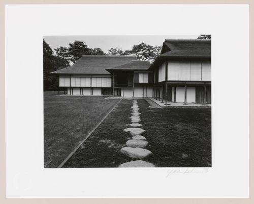
- Photographs PH1986:0148 - PH1986:0283 form a sequence of views. Accession numbers follow an order established by the photographer that is based on the temporal experience of walking through the grounds of Katsura Rikyu (also known as Katsura Imperial Villa) (see acquisition file). - After first photographing Katsura Rikyu (also known as Katsura Imperial Villa) in 1953, Yasuhiro Ishimoto returned there in 1982 and took another series of photographs, this time with many in colour, often using the same or very similar views to those of his 1953 photographs (Ishimoto, pp. 265-266). - This photograph shows the south lawn (also known as the court football [kemari] field) in the foreground, at left, and the moss garden in the foreground, at right (Isozaki, et al, pp. 52-53, repr.; pp. 68-69, repr.; pp. 78, repr.; p. 244; Ito, site plan; Tange, n.p., plan).
PH1986:0193
Description:
- Photographs PH1986:0148 - PH1986:0283 form a sequence of views. Accession numbers follow an order established by the photographer that is based on the temporal experience of walking through the grounds of Katsura Rikyu (also known as Katsura Imperial Villa) (see acquisition file). - After first photographing Katsura Rikyu (also known as Katsura Imperial Villa) in 1953, Yasuhiro Ishimoto returned there in 1982 and took another series of photographs, this time with many in colour, often using the same or very similar views to those of his 1953 photographs (Ishimoto, pp. 265-266). - This photograph shows the south lawn (also known as the court football [kemari] field) in the foreground, at left, and the moss garden in the foreground, at right (Isozaki, et al, pp. 52-53, repr.; pp. 68-69, repr.; pp. 78, repr.; p. 244; Ito, site plan; Tange, n.p., plan).
Personnes et institutions:
Sujet:
architecture, architecture de paysage
architecture, architecture de paysage
Date:
1982
1982
Titre:
View of the New Palace (also known as the New Goten), the Music Room and the Middle Shoin showing stepping-stones in the foreground, Katsura Rikyu (also known as Katsura Imperial Villa), Kyoto, Japan
Actions:
PH1986:0193
Description:
- Photographs PH1986:0148 - PH1986:0283 form a sequence of views. Accession numbers follow an order established by the photographer that is based on the temporal experience of walking through the grounds of Katsura Rikyu (also known as Katsura Imperial Villa) (see acquisition file). - After first photographing Katsura Rikyu (also known as Katsura Imperial Villa) in 1953, Yasuhiro Ishimoto returned there in 1982 and took another series of photographs, this time with many in colour, often using the same or very similar views to those of his 1953 photographs (Ishimoto, pp. 265-266). - This photograph shows the south lawn (also known as the court football [kemari] field) in the foreground, at left, and the moss garden in the foreground, at right (Isozaki, et al, pp. 52-53, repr.; pp. 68-69, repr.; pp. 78, repr.; p. 244; Ito, site plan; Tange, n.p., plan).
View of the New Palace (also known as the New Goten), the Music Room and the Middle Shoin showing stepping-stones in the foreground, Katsura Rikyu (also known as Katsura Imperial Villa), Kyoto, Japan
Actions:
PH1986:0193
Description:
- Photographs PH1986:0148 - PH1986:0283 form a sequence of views. Accession numbers follow an order established by the photographer that is based on the temporal experience of walking through the grounds of Katsura Rikyu (also known as Katsura Imperial Villa) (see acquisition file). - After first photographing Katsura Rikyu (also known as Katsura Imperial Villa) in 1953, Yasuhiro Ishimoto returned there in 1982 and took another series of photographs, this time with many in colour, often using the same or very similar views to those of his 1953 photographs (Ishimoto, pp. 265-266). - This photograph shows the south lawn (also known as the court football [kemari] field) in the foreground, at left, and the moss garden in the foreground, at right (Isozaki, et al, pp. 52-53, repr.; pp. 68-69, repr.; pp. 78, repr.; p. 244; Ito, site plan; Tange, n.p., plan).
Classification:
photographies
photographies
Date:
1982
1982
Personnes et institutions:
Sujet:
architecture, architecture de paysage
architecture, architecture de paysage
Classification:
archives
Niveau de description archivistique:
Fonds
archives
Niveau de description archivistique:
Fonds
Titre:
Fonds Jean Michaud
Fonds Jean Michaud
Numéro de référence:
AP012
Résumé:
Le Fonds Jean Michaud est constitué autour de 5 projets étudiants, 79 projets professionnels, 6 projets non identifiés, 13 projets réalisés par d'autres architectes, ainsi que divers documents visuels et textuels. Les projets de l'architecte sont répartis en 42 projets résidentiels, 4 pour les loisirs et l'animation sociale, 9 éducatifs, 7 commerciaux et administratifs, 3 industriels et manufacturiers, 1 pour le transport routier, 9 gouvernementales, 1 médical, 2 religieux et 1 projet d'aménagement urbain. Ces projets sont principalement concentrés dans quatre régions du Québec. Il y en a 29 dans la région de Montréal (incluant Laval et Vaudreuil-Dorion; dont 17 à Montréal), 20 dans la région du Bas-Saint-Laurent et Gaspésie (11 à Rimouski), 12 en Montérégie (8 à Saint-Marc-sur-Richelieu) et 7 dans les Laurentides. Le fonds Jean Michaud comprend 1613 dessins, 959 reprographies, 271 documents photographiques, 43 documents graphiques, 1 maquette, ainsi que 2.805 m.l. de documents textuels. Ces documents ont été principalement produits entre 1950 et 1970.
AP012
Résumé:
Le Fonds Jean Michaud est constitué autour de 5 projets étudiants, 79 projets professionnels, 6 projets non identifiés, 13 projets réalisés par d'autres architectes, ainsi que divers documents visuels et textuels. Les projets de l'architecte sont répartis en 42 projets résidentiels, 4 pour les loisirs et l'animation sociale, 9 éducatifs, 7 commerciaux et administratifs, 3 industriels et manufacturiers, 1 pour le transport routier, 9 gouvernementales, 1 médical, 2 religieux et 1 projet d'aménagement urbain. Ces projets sont principalement concentrés dans quatre régions du Québec. Il y en a 29 dans la région de Montréal (incluant Laval et Vaudreuil-Dorion; dont 17 à Montréal), 20 dans la région du Bas-Saint-Laurent et Gaspésie (11 à Rimouski), 12 en Montérégie (8 à Saint-Marc-sur-Richelieu) et 7 dans les Laurentides. Le fonds Jean Michaud comprend 1613 dessins, 959 reprographies, 271 documents photographiques, 43 documents graphiques, 1 maquette, ainsi que 2.805 m.l. de documents textuels. Ces documents ont été principalement produits entre 1950 et 1970.
Personnes et institutions:
Date:
1852, 1916, 1938-1981, surtout 1950-1974
1852, 1916, 1938-1981, surtout 1950-1974
Titre:
Fonds Jean Michaud
Actions:
AP012
Résumé:
Le Fonds Jean Michaud est constitué autour de 5 projets étudiants, 79 projets professionnels, 6 projets non identifiés, 13 projets réalisés par d'autres architectes, ainsi que divers documents visuels et textuels. Les projets de l'architecte sont répartis en 42 projets résidentiels, 4 pour les loisirs et l'animation sociale, 9 éducatifs, 7 commerciaux et administratifs, 3 industriels et manufacturiers, 1 pour le transport routier, 9 gouvernementales, 1 médical, 2 religieux et 1 projet d'aménagement urbain. Ces projets sont principalement concentrés dans quatre régions du Québec. Il y en a 29 dans la région de Montréal (incluant Laval et Vaudreuil-Dorion; dont 17 à Montréal), 20 dans la région du Bas-Saint-Laurent et Gaspésie (11 à Rimouski), 12 en Montérégie (8 à Saint-Marc-sur-Richelieu) et 7 dans les Laurentides. Le fonds Jean Michaud comprend 1613 dessins, 959 reprographies, 271 documents photographiques, 43 documents graphiques, 1 maquette, ainsi que 2.805 m.l. de documents textuels. Ces documents ont été principalement produits entre 1950 et 1970.
Fonds Jean Michaud
Actions:
AP012
Résumé:
Le Fonds Jean Michaud est constitué autour de 5 projets étudiants, 79 projets professionnels, 6 projets non identifiés, 13 projets réalisés par d'autres architectes, ainsi que divers documents visuels et textuels. Les projets de l'architecte sont répartis en 42 projets résidentiels, 4 pour les loisirs et l'animation sociale, 9 éducatifs, 7 commerciaux et administratifs, 3 industriels et manufacturiers, 1 pour le transport routier, 9 gouvernementales, 1 médical, 2 religieux et 1 projet d'aménagement urbain. Ces projets sont principalement concentrés dans quatre régions du Québec. Il y en a 29 dans la région de Montréal (incluant Laval et Vaudreuil-Dorion; dont 17 à Montréal), 20 dans la région du Bas-Saint-Laurent et Gaspésie (11 à Rimouski), 12 en Montérégie (8 à Saint-Marc-sur-Richelieu) et 7 dans les Laurentides. Le fonds Jean Michaud comprend 1613 dessins, 959 reprographies, 271 documents photographiques, 43 documents graphiques, 1 maquette, ainsi que 2.805 m.l. de documents textuels. Ces documents ont été principalement produits entre 1950 et 1970.
Classification:
archives
Niveau de description archivistique:
Fonds
archives
Niveau de description archivistique:
Fonds
Date:
1852, 1916, 1938-1981, surtout 1950-1974
1852, 1916, 1938-1981, surtout 1950-1974
Personnes et institutions:
Niveau de description archivistique:
Série(s)
Série(s)
Numéro de référence:
AP082.S1
Description:
The series “Project for a Universal Headquarters Building, Universal City, Los Angeles County, California (1995-1999)” documents an unexecuted project by the Office for Metropolitan Architecture (OMA) and collaborators for a Headquarters Building for Universal Studios at the Universal City site in Los Angeles County, California. The first two years of the design process (1996-1997) are documented by about 500 drawings, over 150 small-scale study models, 105 presentation panels, two flip-books, and a few proposals—including a book illustrating “a day in the life” of the building. Three proposals in the series were produced by OMA or by the engineering firm Ove Arup & Partners at the end of the schematic design phase of the project (March-December 1997). The design development phase of the project (August 1998-July 1999) is documented by a progress report produced for the “50%” stage and project manuals produced for the “60%” and “100%” stages. The series includes a set of reproductions of architectural, structural and mechanical drawings produced at the 100% design development stage together with concept drawings for interiors. Materials produced for a final design development presentation in July 1999 include a book and a large-scale (1:50) presentation model. The series also includes prospectuses and pre-construction proposals from contractors, some graphic design samples, technical reports-- including a ground motion study and a report on wind tunnel tests, and a preliminary furniture budget.
AP082.S1
Description:
The series “Project for a Universal Headquarters Building, Universal City, Los Angeles County, California (1995-1999)” documents an unexecuted project by the Office for Metropolitan Architecture (OMA) and collaborators for a Headquarters Building for Universal Studios at the Universal City site in Los Angeles County, California. The first two years of the design process (1996-1997) are documented by about 500 drawings, over 150 small-scale study models, 105 presentation panels, two flip-books, and a few proposals—including a book illustrating “a day in the life” of the building. Three proposals in the series were produced by OMA or by the engineering firm Ove Arup & Partners at the end of the schematic design phase of the project (March-December 1997). The design development phase of the project (August 1998-July 1999) is documented by a progress report produced for the “50%” stage and project manuals produced for the “60%” and “100%” stages. The series includes a set of reproductions of architectural, structural and mechanical drawings produced at the 100% design development stage together with concept drawings for interiors. Materials produced for a final design development presentation in July 1999 include a book and a large-scale (1:50) presentation model. The series also includes prospectuses and pre-construction proposals from contractors, some graphic design samples, technical reports-- including a ground motion study and a report on wind tunnel tests, and a preliminary furniture budget.
Personnes et institutions:
Date:
1996-1999
1996-1999
Titre:
Project for a Universal Headquarters Building, Universal City, Los Angeles County, California (1995-1999)
Actions:
AP082.S1
Description:
The series “Project for a Universal Headquarters Building, Universal City, Los Angeles County, California (1995-1999)” documents an unexecuted project by the Office for Metropolitan Architecture (OMA) and collaborators for a Headquarters Building for Universal Studios at the Universal City site in Los Angeles County, California. The first two years of the design process (1996-1997) are documented by about 500 drawings, over 150 small-scale study models, 105 presentation panels, two flip-books, and a few proposals—including a book illustrating “a day in the life” of the building. Three proposals in the series were produced by OMA or by the engineering firm Ove Arup & Partners at the end of the schematic design phase of the project (March-December 1997). The design development phase of the project (August 1998-July 1999) is documented by a progress report produced for the “50%” stage and project manuals produced for the “60%” and “100%” stages. The series includes a set of reproductions of architectural, structural and mechanical drawings produced at the 100% design development stage together with concept drawings for interiors. Materials produced for a final design development presentation in July 1999 include a book and a large-scale (1:50) presentation model. The series also includes prospectuses and pre-construction proposals from contractors, some graphic design samples, technical reports-- including a ground motion study and a report on wind tunnel tests, and a preliminary furniture budget.
Project for a Universal Headquarters Building, Universal City, Los Angeles County, California (1995-1999)
Actions:
AP082.S1
Description:
The series “Project for a Universal Headquarters Building, Universal City, Los Angeles County, California (1995-1999)” documents an unexecuted project by the Office for Metropolitan Architecture (OMA) and collaborators for a Headquarters Building for Universal Studios at the Universal City site in Los Angeles County, California. The first two years of the design process (1996-1997) are documented by about 500 drawings, over 150 small-scale study models, 105 presentation panels, two flip-books, and a few proposals—including a book illustrating “a day in the life” of the building. Three proposals in the series were produced by OMA or by the engineering firm Ove Arup & Partners at the end of the schematic design phase of the project (March-December 1997). The design development phase of the project (August 1998-July 1999) is documented by a progress report produced for the “50%” stage and project manuals produced for the “60%” and “100%” stages. The series includes a set of reproductions of architectural, structural and mechanical drawings produced at the 100% design development stage together with concept drawings for interiors. Materials produced for a final design development presentation in July 1999 include a book and a large-scale (1:50) presentation model. The series also includes prospectuses and pre-construction proposals from contractors, some graphic design samples, technical reports-- including a ground motion study and a report on wind tunnel tests, and a preliminary furniture budget.
Niveau de description archivistique:
Series
Series
Date:
1996-1999
1996-1999
Personnes et institutions:


