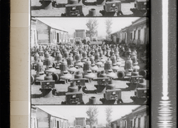
950 Résultats
Classification:
articles
articles
Publié:
2 août 2021
2 août 2021
Classification:
dessins
dessins
Numéro de référence:
DR1987:0663
Description:
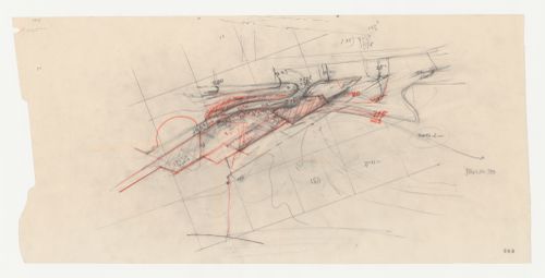
- This drawing is possibly a conceptual drawing for Wayfarers' Chapel, Palos Verdes, California. The area enclosed by the plan is similar to that of the sketch plan for the parish house and cloister on drawing DR1987:0667. If this drawing is for the parish house, then the road at the upper centre of the drawing would be an access road off Narcissa Drive, the northern boundary of the site, while the curve at the bottom would represent Palos Verdes Drive South.
DR1987:0663
Description:
- This drawing is possibly a conceptual drawing for Wayfarers' Chapel, Palos Verdes, California. The area enclosed by the plan is similar to that of the sketch plan for the parish house and cloister on drawing DR1987:0667. If this drawing is for the parish house, then the road at the upper centre of the drawing would be an access road off Narcissa Drive, the northern boundary of the site, while the curve at the bottom would represent Palos Verdes Drive South.
Personnes et institutions:
Sujet:
architecture
architecture
Date:
1954
1954
Titre:
Wayfarers' Chapel, Palos Verdes, California: Conceptual drawing, possibly for the parish house
Actions:
DR1987:0663
Description:
- This drawing is possibly a conceptual drawing for Wayfarers' Chapel, Palos Verdes, California. The area enclosed by the plan is similar to that of the sketch plan for the parish house and cloister on drawing DR1987:0667. If this drawing is for the parish house, then the road at the upper centre of the drawing would be an access road off Narcissa Drive, the northern boundary of the site, while the curve at the bottom would represent Palos Verdes Drive South.
Classification:
dessins
dessins
Date:
1954
1954
Personnes et institutions:
Sujet:
architecture
architecture
Classification:
événements
événements
Actions:
Description:
Philip Ursprung, commissaire invité de l’exposition Herzog de Meuron : archéologie de l’imaginaire tenue au CCA en 2002, discute du rapport collaboratif de Herzog de Meuron avec les artistes. La conférence fait partie d’une série présentée en complément de l’exposition qui explore les frontières entre l’art et l’architecture. Philip Ursprung est professeur en histoire(...)
Philip Ursprung, commissaire invité de l’exposition Herzog de Meuron : archéologie de l’imaginaire tenue au CCA en 2002, discute du rapport collaboratif de Herzog de Meuron avec les artistes. La conférence fait partie d’une série présentée en complément de l’exposition qui explore les frontières entre l’art et l’architecture. Philip Ursprung est professeur en histoire(...)
Date:
17 octobre 2002
17 octobre 2002
Titre:
Philip Ursprung : Close Encounters : Herzog & de Meuron en collaboration avec des artistes
Actions:
Description:
Philip Ursprung, commissaire invité de l’exposition Herzog de Meuron : archéologie de l’imaginaire tenue au CCA en 2002, discute du rapport collaboratif de Herzog de Meuron avec les artistes. La conférence fait partie d’une série présentée en complément de l’exposition qui explore les frontières entre l’art et l’architecture. Philip Ursprung est professeur en histoire(...)
Classification:
événements
événements
Date:
17 octobre 2002
17 octobre 2002
Niveau de description archivistique:
Projet
Projet
Numéro de référence:
AP027.S1.D12
Description:
Long-range plan to preserve and expand Mount Royal Park. Definition and recognition of the logical boundaries of the mountain park area are called for by the Save the Mountain Committee. The plan would establish the right of city to acquire all properties within the designated areas as they become available, and would restrict construction and control building heights in the park area. This project was initiated by H. P. Daniel van Ginkel and Blanche Lemco van Ginkel on their own account. The work was executed pro bono with Michel Chevalier, Harry Mayerovitch and Hazen Sise. It was effected with the support of the Montréal Parks and Playground Association. The recommendations were accepted and embodied in a private bill by the Québec Provincial Legislature and in the bylaws of the City of Montréal.
Personnes et institutions:
Sujet:
urbanisme
urbanisme
Date:
1960
1960
Titre:
Save the Mountain
Actions:
AP027.S1.D12
Description:
Long-range plan to preserve and expand Mount Royal Park. Definition and recognition of the logical boundaries of the mountain park area are called for by the Save the Mountain Committee. The plan would establish the right of city to acquire all properties within the designated areas as they become available, and would restrict construction and control building heights in the park area. This project was initiated by H. P. Daniel van Ginkel and Blanche Lemco van Ginkel on their own account. The work was executed pro bono with Michel Chevalier, Harry Mayerovitch and Hazen Sise. It was effected with the support of the Montréal Parks and Playground Association. The recommendations were accepted and embodied in a private bill by the Québec Provincial Legislature and in the bylaws of the City of Montréal.
Niveau de description archivistique:
File 12
File 12
Date:
1960
1960
Personnes et institutions:
Sujet:
urbanisme
urbanisme
Niveau de description archivistique:
Projet
Projet
Titre:
Red Line (1972)
Red Line (1972)
Numéro de référence:
AP207.S1.1972.PR04
Description:
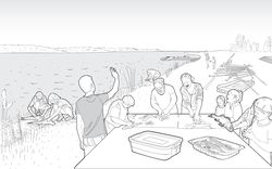
The project series documents "Red Line", a performance that consisted in tracing a red line in the middle of the road with paint sprayer and compressor loaded on the back of a truck. The red line stretched across forty-five kilometres of road and traced the limits of the municipality of Salt Lake City. "The red line rendered visible the boundaries that structure our mental fields of perception and modify our understanding of space." [1] The performance was carried out in February and March 1972 with a group of students from the University of Utah, in Salt Lake City. The project series contains photographs of Pettena and his team at work tracing the red line, a drawing, and a map of the Salt Lake City municipality showing the trajectory of the line. Source: [1] Marco Scotini, editor. Non-conscious architecture: Gianni Pettena, Sternberg Press, 2018, 235 pages. p. 168.
AP207.S1.1972.PR04
Description:
The project series documents "Red Line", a performance that consisted in tracing a red line in the middle of the road with paint sprayer and compressor loaded on the back of a truck. The red line stretched across forty-five kilometres of road and traced the limits of the municipality of Salt Lake City. "The red line rendered visible the boundaries that structure our mental fields of perception and modify our understanding of space." [1] The performance was carried out in February and March 1972 with a group of students from the University of Utah, in Salt Lake City. The project series contains photographs of Pettena and his team at work tracing the red line, a drawing, and a map of the Salt Lake City municipality showing the trajectory of the line. Source: [1] Marco Scotini, editor. Non-conscious architecture: Gianni Pettena, Sternberg Press, 2018, 235 pages. p. 168.
Personnes et institutions:
Date:
circa 1972-2015
circa 1972-2015
Titre:
Red Line (1972)
Actions:
AP207.S1.1972.PR04
Description:
The project series documents "Red Line", a performance that consisted in tracing a red line in the middle of the road with paint sprayer and compressor loaded on the back of a truck. The red line stretched across forty-five kilometres of road and traced the limits of the municipality of Salt Lake City. "The red line rendered visible the boundaries that structure our mental fields of perception and modify our understanding of space." [1] The performance was carried out in February and March 1972 with a group of students from the University of Utah, in Salt Lake City. The project series contains photographs of Pettena and his team at work tracing the red line, a drawing, and a map of the Salt Lake City municipality showing the trajectory of the line. Source: [1] Marco Scotini, editor. Non-conscious architecture: Gianni Pettena, Sternberg Press, 2018, 235 pages. p. 168.
Niveau de description archivistique:
Project
Project
Date:
circa 1972-2015
circa 1972-2015
Personnes et institutions:
Classification:
expositions
expositions
Titre:
Sur les traces de… fenêtres
Sur les traces de… fenêtres
Actions:
Description:
Une fenêtre peut être un vide, une ouverture ou devenir une surface de verre. Placées aux frontières de l’intérieur et de l’extérieur, les fenêtres permettent à la lumière et à l’air d’entrer, et cadrent les vues. L’idée de fenêtre, combinée aux avancées dans les domaines du verre et des matériaux de construction, devient centrale dans l’expérimentation architecturale au(...)
Une fenêtre peut être un vide, une ouverture ou devenir une surface de verre. Placées aux frontières de l’intérieur et de l’extérieur, les fenêtres permettent à la lumière et à l’air d’entrer, et cadrent les vues. L’idée de fenêtre, combinée aux avancées dans les domaines du verre et des matériaux de construction, devient centrale dans l’expérimentation architecturale au(...)
Localisation:
Vitrines
Vitrines
Date:
17 juin 2010 au 27 septembre 2010
17 juin 2010 au 27 septembre 2010
Titre:
Sur les traces de… fenêtres
Actions:
Description:
Une fenêtre peut être un vide, une ouverture ou devenir une surface de verre. Placées aux frontières de l’intérieur et de l’extérieur, les fenêtres permettent à la lumière et à l’air d’entrer, et cadrent les vues. L’idée de fenêtre, combinée aux avancées dans les domaines du verre et des matériaux de construction, devient centrale dans l’expérimentation architecturale au(...)
Classification:
expositions
expositions
Date:
17 juin 2010 au
27 septembre 2010
17 juin 2010 au
27 septembre 2010
Localisation:
Vitrines
Vitrines
Classification:
événements
événements
Actions:
Description:
Cette présentation revisite l’héritage visuel controversé du documentaire Chung Kuo, Cina (1972) réalisé par Michelangelo Antonioni, en le replaçant au sein d’un réseau élargi d’échanges et de rencontres à l’époque de la guerre froide entre les cinéastes occidentaux et une République populaire de Chine à limage méticuleusement élaborée. En établissant des parallèles entre(...)
Cette présentation revisite l’héritage visuel controversé du documentaire Chung Kuo, Cina (1972) réalisé par Michelangelo Antonioni, en le replaçant au sein d’un réseau élargi d’échanges et de rencontres à l’époque de la guerre froide entre les cinéastes occidentaux et une République populaire de Chine à limage méticuleusement élaborée. En établissant des parallèles entre(...)
Localisation:
Théâtre Paul-Desmarais
Théâtre Paul-Desmarais
Date:
22 janvier 2026, 18h à 19h30
22 janvier 2026, 18h à 19h30
Titre:
Projection d’extraits de film et annotation en direct : Chung Kuo, Cina d’Antonioni (1972)
Actions:
Description:
Cette présentation revisite l’héritage visuel controversé du documentaire Chung Kuo, Cina (1972) réalisé par Michelangelo Antonioni, en le replaçant au sein d’un réseau élargi d’échanges et de rencontres à l’époque de la guerre froide entre les cinéastes occidentaux et une République populaire de Chine à limage méticuleusement élaborée. En établissant des parallèles entre(...)
Classification:
événements
événements
Date:
22 janvier 2026
18h à 19h30
22 janvier 2026
18h à 19h30
Localisation:
Théâtre Paul-Desmarais
Théâtre Paul-Desmarais
Niveau de description archivistique:
Projet
Projet
Numéro de référence:
AP166.S1.1991.PR2
Description:
This project series documents the project "Glass Station", a gas station constructed on an irregularly-shaped site at the entrance to the town of Oguni in Kumamoto Prefecture, Japan. The project was completed in 1993. The office, pumps, shop and work space of the service station are covered by an undulating canopy composed of asymmetrical concrete arches that form the boundaries of a lattice of pretensioned steel rods and aluminum channels into which panels of glass bonded to sheets of perforated stainless steel were inserted, sealed with polyester film, and secured with structural silicon. The project series is chiefly composed of design development drawings. It includes numbered sets of architectural drawings and structural drawings and some mechanical and electrical drawings. There is a set of unnumbered ink drawings and reproductions related to the geometry of the canopy. There are also some images of the canopy that are output from a computer file or files (wireframes and renderings). There is a small amount of textual material related to technical data and form finding for the canopy. The file also includes 2 study models. There are some graphic design documents for the name of the project and for the name "IDEX". Material in this file was created between 1990 and 1993.
Personnes et institutions:
Date:
1990-1993
1990-1993
Titre:
Glass Station, Oguni, Japan (1990-1993)
Actions:
AP166.S1.1991.PR2
Description:
This project series documents the project "Glass Station", a gas station constructed on an irregularly-shaped site at the entrance to the town of Oguni in Kumamoto Prefecture, Japan. The project was completed in 1993. The office, pumps, shop and work space of the service station are covered by an undulating canopy composed of asymmetrical concrete arches that form the boundaries of a lattice of pretensioned steel rods and aluminum channels into which panels of glass bonded to sheets of perforated stainless steel were inserted, sealed with polyester film, and secured with structural silicon. The project series is chiefly composed of design development drawings. It includes numbered sets of architectural drawings and structural drawings and some mechanical and electrical drawings. There is a set of unnumbered ink drawings and reproductions related to the geometry of the canopy. There are also some images of the canopy that are output from a computer file or files (wireframes and renderings). There is a small amount of textual material related to technical data and form finding for the canopy. The file also includes 2 study models. There are some graphic design documents for the name of the project and for the name "IDEX". Material in this file was created between 1990 and 1993.
Niveau de description archivistique:
project
project
Date:
1990-1993
1990-1993
Personnes et institutions:
Classification:
expositions
expositions
Actions:
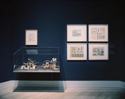
Description:
L’architecture, quoique soumise aux impératifs de la fonction et de la structure, sera toujours en définitive un acte d’imagination. L’exposition Architecture potentielle : jeux de construction de la collection du CCA réunit vingt et un jeux de construction fabriqués entre 1850 et 1950, qui ont été conçus pour éveiller la créativité chez l’enfant. Les jeux montrent(...)
L’architecture, quoique soumise aux impératifs de la fonction et de la structure, sera toujours en définitive un acte d’imagination. L’exposition Architecture potentielle : jeux de construction de la collection du CCA réunit vingt et un jeux de construction fabriqués entre 1850 et 1950, qui ont été conçus pour éveiller la créativité chez l’enfant. Les jeux montrent(...)
Localisation:
Salle octogonale
Salle octogonale
Date:
4 décembre 1991 au 8 mars 1992
4 décembre 1991 au 8 mars 1992
Titre:
Architecture potentielle : jeux de construction de la collection du CCA
Actions:
Description:
L’architecture, quoique soumise aux impératifs de la fonction et de la structure, sera toujours en définitive un acte d’imagination. L’exposition Architecture potentielle : jeux de construction de la collection du CCA réunit vingt et un jeux de construction fabriqués entre 1850 et 1950, qui ont été conçus pour éveiller la créativité chez l’enfant. Les jeux montrent(...)
Classification:
expositions
expositions
Date:
4 décembre 1991 au
8 mars 1992
4 décembre 1991 au
8 mars 1992
Localisation:
Salle octogonale
Salle octogonale
Classification:
documents textuels
documents textuels
Numéro de référence:
ARCH255289
Description:
Proposal by the Ministry of Treasury, Economics and Intergovernmental Affairs to define area boundaries and develop transportation and recreation in the Parkway Belt System which extends from Dundas west of Toronto to Oshawa.
ARCH255289
Description:
Proposal by the Ministry of Treasury, Economics and Intergovernmental Affairs to define area boundaries and develop transportation and recreation in the Parkway Belt System which extends from Dundas west of Toronto to Oshawa.
Date:
1975
1975
Titre:
Interim Draft: Parkway Belt West Plan
Actions:
ARCH255289
Description:
Proposal by the Ministry of Treasury, Economics and Intergovernmental Affairs to define area boundaries and develop transportation and recreation in the Parkway Belt System which extends from Dundas west of Toronto to Oshawa.
Interim Draft: Parkway Belt West Plan
Actions:
ARCH255289
Description:
Proposal by the Ministry of Treasury, Economics and Intergovernmental Affairs to define area boundaries and develop transportation and recreation in the Parkway Belt System which extends from Dundas west of Toronto to Oshawa.
Classification:
documents textuels
documents textuels
Date:
1975
1975