5646 Résultats
Classification:
photographies
photographies
Actions:
Numéro de référence:
PH1989:0262.04:050
Description:
Sculpture showing the colossal figure of Godfrey of Bouillon on horseback, raising the banner with which he led the Crusaders to the Holy Land (original bronze in the Place Royale in Brussels).
PH1989:0262.04:050
Description:
Sculpture showing the colossal figure of Godfrey of Bouillon on horseback, raising the banner with which he led the Crusaders to the Holy Land (original bronze in the Place Royale in Brussels).
Personnes et institutions:
Sujet:
sculpture
sculpture
Date:
1851
1851
Titre:
Godfrey de Bouillon (plaster)
Actions:
PH1989:0262.04:050
Description:
Sculpture showing the colossal figure of Godfrey of Bouillon on horseback, raising the banner with which he led the Crusaders to the Holy Land (original bronze in the Place Royale in Brussels).
Godfrey de Bouillon (plaster)
Actions:
PH1989:0262.04:050
Description:
Sculpture showing the colossal figure of Godfrey of Bouillon on horseback, raising the banner with which he led the Crusaders to the Holy Land (original bronze in the Place Royale in Brussels).
Classification:
photographies
photographies
Date:
1851
1851
Personnes et institutions:
Sujet:
sculpture
sculpture
Niveau de description archivistique:
Projet
Projet
Titre:
Strate
Strate
Numéro de référence:
AP144.S2.D141
Description:
File documents a set of studies and proposals for redevelopment of an area of British Rail land in Stratford, London, including the station at Stratford East. Price's central proposal was to relocate Stratford Station to the west in order to directly engage it with the North London Line, the Docklands Light Railway, London Transport's Central Line and the British Rail main line. Material in this file was produced between 1985 and 1988, but predominantly between 1986 and 1987. File contains conceptual drawings, reference drawings, presentation panels, photographic materials and textual records.
Personnes et institutions:
Date:
1985-1988, predominant 1986-1987
1985-1988, predominant 1986-1987
Titre:
Strate
Actions:
AP144.S2.D141
Description:
File documents a set of studies and proposals for redevelopment of an area of British Rail land in Stratford, London, including the station at Stratford East. Price's central proposal was to relocate Stratford Station to the west in order to directly engage it with the North London Line, the Docklands Light Railway, London Transport's Central Line and the British Rail main line. Material in this file was produced between 1985 and 1988, but predominantly between 1986 and 1987. File contains conceptual drawings, reference drawings, presentation panels, photographic materials and textual records.
Niveau de description archivistique:
File 141
File 141
Date:
1985-1988, predominant 1986-1987
1985-1988, predominant 1986-1987
Personnes et institutions:
Classification:
dessins
dessins
Numéro de référence:
AP206.S1.1982.PR26.009
Description:
This file documents an unidentified housing project, likely dating from sometime in the 1980s or 1990s. The project consisted of 336 units and 140 booths on a 5 acre area of land.
AP206.S1.1982.PR26.009
Description:
This file documents an unidentified housing project, likely dating from sometime in the 1980s or 1990s. The project consisted of 336 units and 140 booths on a 5 acre area of land.
Personnes et institutions:
Date:
circa 1980s-1990s
circa 1980s-1990s
Titre:
Unidentified housing sketch, concept layout, plan and section
Actions:
AP206.S1.1982.PR26.009
Description:
This file documents an unidentified housing project, likely dating from sometime in the 1980s or 1990s. The project consisted of 336 units and 140 booths on a 5 acre area of land.
Unidentified housing sketch, concept layout, plan and section
Actions:
AP206.S1.1982.PR26.009
Description:
This file documents an unidentified housing project, likely dating from sometime in the 1980s or 1990s. The project consisted of 336 units and 140 booths on a 5 acre area of land.
Classification:
dessins
dessins
Date:
circa 1980s-1990s
circa 1980s-1990s
Personnes et institutions:
Classification:
dessins
dessins
Numéro de référence:
ARCH33299
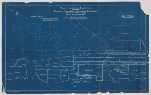
Description:
Drawing 2.1-9, Plan Indicating Elevations on Part of the Royal Victoria Hospital Property, St. Antoine Ward, City of Montreal Montreal 7th July 1930 Prepared by Malcolm [?] Barclay [?] Quebec Land Surveyor
ARCH33299
Description:
Drawing 2.1-9, Plan Indicating Elevations on Part of the Royal Victoria Hospital Property, St. Antoine Ward, City of Montreal Montreal 7th July 1930 Prepared by Malcolm [?] Barclay [?] Quebec Land Surveyor
Personnes et institutions:
Date:
1930
1930
Titre:
Royal Victoria Hospital, Montréal, Québec: cadastral plan
Actions:
ARCH33299
Description:
Drawing 2.1-9, Plan Indicating Elevations on Part of the Royal Victoria Hospital Property, St. Antoine Ward, City of Montreal Montreal 7th July 1930 Prepared by Malcolm [?] Barclay [?] Quebec Land Surveyor
Royal Victoria Hospital, Montréal, Québec: cadastral plan
Actions:
ARCH33299
Description:
Drawing 2.1-9, Plan Indicating Elevations on Part of the Royal Victoria Hospital Property, St. Antoine Ward, City of Montreal Montreal 7th July 1930 Prepared by Malcolm [?] Barclay [?] Quebec Land Surveyor
Classification:
dessins
dessins
Date:
1930
1930
Personnes et institutions:
Classification:
articles
articles

Actions:
Tiffany Shaw s’entretient avec Rafico Ruiz et Ella den Elzen à propos des espaces intermédiaires, de la conception des expositions et des liens avec le territoire
Mot(s)-clé(s):
Tiffany Shaw, Rafico Ruiz, Ella den Elzen, design d'exposition, scénographie, asinnajaq, Vers chez soi, Ruovttu Guvlui, ᐊᖏᕐᕋᒧᑦ
Tiffany Shaw, Rafico Ruiz, Ella den Elzen, design d'exposition, scénographie, asinnajaq, Vers chez soi, Ruovttu Guvlui, ᐊᖏᕐᕋᒧᑦ
Publié:
6 septembre 2022
6 septembre 2022
Titre:
Concevoir un espace comme chez soi
Tiffany Shaw s’entretient avec Rafico Ruiz et Ella den Elzen à propos des espaces intermédiaires, de la conception des expositions et des liens avec le territoire
Actions:
Concevoir un espace comme chez soi
Tiffany Shaw s’entretient avec Rafico Ruiz et Ella den Elzen à propos des espaces intermédiaires, de la conception des expositions et des liens avec le territoire
Actions:
Classification:
dessins
dessins
Numéro de référence:
DR2004:0672
Description:
details, structural drawings, sections, elevations, plans, conceptual drawings, site plans, land surveys, perspectives, design development drawings, presentation drawing from the first Strate project, and site plan from the Anglia project
DR2004:0672
Description:
details, structural drawings, sections, elevations, plans, conceptual drawings, site plans, land surveys, perspectives, design development drawings, presentation drawing from the first Strate project, and site plan from the Anglia project
Personnes et institutions:
Titre:
Details, structural drawings, sections, elevations
Actions:
DR2004:0672
Description:
details, structural drawings, sections, elevations, plans, conceptual drawings, site plans, land surveys, perspectives, design development drawings, presentation drawing from the first Strate project, and site plan from the Anglia project
Classification:
dessins
dessins
Personnes et institutions:
Classification:
dessins
Quantité:
85 working drawing(s)
dessins
Quantité:
85 working drawing(s)
Numéro de référence:
DR2004:0692
Description:
consultants' drawings, some with notes, schedules and specifications, including structural drawings, building systems drawings, details, sections, plans, elevations, site plans, measured sketches, reference drawings, land surveys, and design development drawings
DR2004:0692
Description:
consultants' drawings, some with notes, schedules and specifications, including structural drawings, building systems drawings, details, sections, plans, elevations, site plans, measured sketches, reference drawings, land surveys, and design development drawings
Personnes et institutions:
Titre:
Consultants' drawings, some with notes, schedules and specifications
Actions:
DR2004:0692
Description:
consultants' drawings, some with notes, schedules and specifications, including structural drawings, building systems drawings, details, sections, plans, elevations, site plans, measured sketches, reference drawings, land surveys, and design development drawings
Classification:
dessins
Quantité:
85 working drawing(s)
dessins
Quantité:
85 working drawing(s)
Personnes et institutions:
Classification:
oeuvres d'art
oeuvres d'art
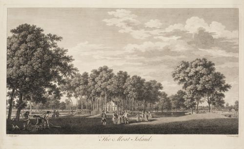
Titre:
View of the Moat Island
View of the Moat Island
Actions:
Numéro de référence:
DR1987:0106:004
Description:
- A view of a small ornate cottage set in a stand of trees on a piece of land surrounded by water, and with a group of figures, among them the Duke of Cumberland[?], in the foreground.
DR1987:0106:004
Description:
- A view of a small ornate cottage set in a stand of trees on a piece of land surrounded by water, and with a group of figures, among them the Duke of Cumberland[?], in the foreground.
Personnes et institutions:
Sujet:
architecture, architecture de paysage, topographique
architecture, architecture de paysage, topographique
Date:
1754 or 1755
1754 or 1755
Titre:
View of the Moat Island
Actions:
DR1987:0106:004
Description:
- A view of a small ornate cottage set in a stand of trees on a piece of land surrounded by water, and with a group of figures, among them the Duke of Cumberland[?], in the foreground.
View of the Moat Island
Actions:
DR1987:0106:004
Description:
- A view of a small ornate cottage set in a stand of trees on a piece of land surrounded by water, and with a group of figures, among them the Duke of Cumberland[?], in the foreground.
Classification:
oeuvres d'art
oeuvres d'art
Date:
1754 or 1755
1754 or 1755
Personnes et institutions:
Sujet:
architecture, architecture de paysage, topographique
architecture, architecture de paysage, topographique
Classification:
dessins
dessins
Numéro de référence:
AP046.S1.1983.PR01.015
Description:
This file includes drawings for land drainage, library level floor plan, site plan (annotated), section through skylight, elevations, sections, Shaughnessy House second and third level floor plan, preliminary drafts and implementation phases.
AP046.S1.1983.PR01.015
Description:
This file includes drawings for land drainage, library level floor plan, site plan (annotated), section through skylight, elevations, sections, Shaughnessy House second and third level floor plan, preliminary drafts and implementation phases.
Personnes et institutions:
Date:
February 1983 - December 1983
February 1983 - December 1983
Titre:
Early Shaughnessy House plans as office space and original scheme for Canadian Centre for Architecture, Montréal, Québec
Actions:
AP046.S1.1983.PR01.015
Description:
This file includes drawings for land drainage, library level floor plan, site plan (annotated), section through skylight, elevations, sections, Shaughnessy House second and third level floor plan, preliminary drafts and implementation phases.
Classification:
dessins
dessins
Date:
February 1983 - December 1983
February 1983 - December 1983
Personnes et institutions:
Classification:
documents textuels
documents textuels
Numéro de référence:
ARCH269518
Description:
Includes a brochure about the area issued by the government, a letter to Shoei Yoh from the government, a poster for Toyama Land 10th Anniversary" (1993), and a flyer for the event "Jet Anniversary Festa".
ARCH269518
Description:
Includes a brochure about the area issued by the government, a letter to Shoei Yoh from the government, a poster for Toyama Land 10th Anniversary" (1993), and a flyer for the event "Jet Anniversary Festa".
Personnes et institutions:
Date:
1993
1993
Titre:
Toyama ’92 JET 92 CG graphic (textual records)
Actions:
ARCH269518
Description:
Includes a brochure about the area issued by the government, a letter to Shoei Yoh from the government, a poster for Toyama Land 10th Anniversary" (1993), and a flyer for the event "Jet Anniversary Festa".
Toyama ’92 JET 92 CG graphic (textual records)
Actions:
ARCH269518
Description:
Includes a brochure about the area issued by the government, a letter to Shoei Yoh from the government, a poster for Toyama Land 10th Anniversary" (1993), and a flyer for the event "Jet Anniversary Festa".
Classification:
documents textuels
documents textuels
Date:
1993
1993
Personnes et institutions: