34950 Résultats
Classification:
cartes, dessins
cartes, dessins
Actions:
Numéro de référence:
DR1984:0569
Description:
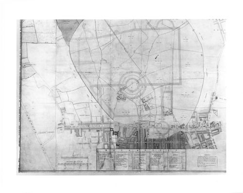
- An engraved map of Marylebone Park and the streets bordering it to the south, with the outline of the street system for an early version of Nash's plan for Regent's Park superimposed in pen and coloured wash.
DR1984:0569
Description:
- An engraved map of Marylebone Park and the streets bordering it to the south, with the outline of the street system for an early version of Nash's plan for Regent's Park superimposed in pen and coloured wash.
Personnes et institutions:
Sujet:
architecture, architecture de paysage, urbanisme
architecture, architecture de paysage, urbanisme
Date:
1811-1812 over a print of ca. 1805
1811-1812 over a print of ca. 1805
Titre:
A preliminary design for Regent's Park drawn over a map of the existing site
Actions:
DR1984:0569
Description:
- An engraved map of Marylebone Park and the streets bordering it to the south, with the outline of the street system for an early version of Nash's plan for Regent's Park superimposed in pen and coloured wash.
Classification:
cartes, dessins
cartes, dessins
Date:
1811-1812 over a print of ca. 1805
1811-1812 over a print of ca. 1805
Personnes et institutions:
Sujet:
architecture, architecture de paysage, urbanisme
architecture, architecture de paysage, urbanisme
Classification:
cartes
cartes
Numéro de référence:
ARCH266230
Description:
Raised-relief map showing volcanoes on the Island of Hawaii, including Mauna Kea volcano where the Canada-France-Hawaii Telescope is situated. Published by the Hawaii Natural History Association in cooperation with Hawaii Volcanoes National Park.
ARCH266230
Description:
Raised-relief map showing volcanoes on the Island of Hawaii, including Mauna Kea volcano where the Canada-France-Hawaii Telescope is situated. Published by the Hawaii Natural History Association in cooperation with Hawaii Volcanoes National Park.
Personnes et institutions:
Titre:
Raised-relief map showing volcanoes on the Island of Hawaii, Hawaii, United States
Actions:
ARCH266230
Description:
Raised-relief map showing volcanoes on the Island of Hawaii, including Mauna Kea volcano where the Canada-France-Hawaii Telescope is situated. Published by the Hawaii Natural History Association in cooperation with Hawaii Volcanoes National Park.
Classification:
cartes
cartes
Personnes et institutions:
Classification:
dessins
dessins
Numéro de référence:
AP046.S1.1983.PR02.197
Description:
This file includes composite context maps for the City of Montreal at 1: 10,000 scale.
AP046.S1.1983.PR02.197
Description:
This file includes composite context maps for the City of Montreal at 1: 10,000 scale.
Personnes et institutions:
Date:
1983-1992
1983-1992
Titre:
Composite map of Montréal, Old Port of Montreal Master Plan, Montréal, Québec
Actions:
AP046.S1.1983.PR02.197
Description:
This file includes composite context maps for the City of Montreal at 1: 10,000 scale.
Composite map of Montréal, Old Port of Montreal Master Plan, Montréal, Québec
Actions:
AP046.S1.1983.PR02.197
Description:
This file includes composite context maps for the City of Montreal at 1: 10,000 scale.
Classification:
dessins
dessins
Date:
1983-1992
1983-1992
Personnes et institutions:
Classification:
dessins
dessins
Numéro de référence:
AP046.S1.1983.PR02.140
Description:
This file includes a map of Montreal at 1: 10,000 scale showing topography and individual buildings.
AP046.S1.1983.PR02.140
Description:
This file includes a map of Montreal at 1: 10,000 scale showing topography and individual buildings.
Personnes et institutions:
Date:
1983-1992
1983-1992
Titre:
Composite context map of Montreal, Old Port of Montreal Master Plan, Montréal, Québec
Actions:
AP046.S1.1983.PR02.140
Description:
This file includes a map of Montreal at 1: 10,000 scale showing topography and individual buildings.
Composite context map of Montreal, Old Port of Montreal Master Plan, Montréal, Québec
Actions:
AP046.S1.1983.PR02.140
Description:
This file includes a map of Montreal at 1: 10,000 scale showing topography and individual buildings.
Classification:
dessins
dessins
Date:
1983-1992
1983-1992
Personnes et institutions:
Classification:
dessins
dessins
Numéro de référence:
AP140.S2.SS1.D70.P37
Description:
Topographic surveys and map of Bilbao, schematic sections for Abando Passenger Interchange relating to first Interchange project.
AP140.S2.SS1.D70.P37
Description:
Topographic surveys and map of Bilbao, schematic sections for Abando Passenger Interchange relating to first Interchange project.
Personnes et institutions:
Date:
circa 1974-1999
circa 1974-1999
Titre:
Topographic surveys and map of Bilbao, schematic sections, Abando Passenger Interchange, Bilbao, Spain
Actions:
AP140.S2.SS1.D70.P37
Description:
Topographic surveys and map of Bilbao, schematic sections for Abando Passenger Interchange relating to first Interchange project.
Topographic surveys and map of Bilbao, schematic sections, Abando Passenger Interchange, Bilbao, Spain
Actions:
AP140.S2.SS1.D70.P37
Description:
Topographic surveys and map of Bilbao, schematic sections for Abando Passenger Interchange relating to first Interchange project.
Classification:
dessins
dessins
Date:
circa 1974-1999
circa 1974-1999
Personnes et institutions:
Classification:
dessins
dessins
Actions:
Numéro de référence:
DR1981:0017:071 R/V
DR1981:0017:071 R/V
Personnes et institutions:
Sujet:
architecture, topographique
architecture, topographique
Date:
circa 1630-1640; verso: 1634
circa 1630-1640; verso: 1634
Classification:
dessins
dessins
Date:
circa 1630-1640; verso: 1634
circa 1630-1640; verso: 1634
Personnes et institutions:
Sujet:
architecture, topographique
architecture, topographique
Classification:
cartes
cartes
Numéro de référence:
DR2004:1187
Description:
map of petroleum license areas in the North Sea and Northwest European continental shelf, and poster of the British Isles from space
DR2004:1187
Description:
map of petroleum license areas in the North Sea and Northwest European continental shelf, and poster of the British Isles from space
Personnes et institutions:
Titre:
Map of petroleum license areas in the North Sea and Northwest European continental shelf
Actions:
DR2004:1187
Description:
map of petroleum license areas in the North Sea and Northwest European continental shelf, and poster of the British Isles from space
Map of petroleum license areas in the North Sea and Northwest European continental shelf
Actions:
DR2004:1187
Description:
map of petroleum license areas in the North Sea and Northwest European continental shelf, and poster of the British Isles from space
Classification:
cartes
cartes
Personnes et institutions:
Classification:
cartes, oeuvres d'art
cartes, oeuvres d'art
Actions:
Numéro de référence:
DR1984:1438
DR1984:1438
Personnes et institutions:
Sujet:
architecture, topographique
architecture, topographique
Date:
1719
1719
Classification:
cartes, oeuvres d'art
cartes, oeuvres d'art
Date:
1719
1719
Personnes et institutions:
Sujet:
architecture, topographique
architecture, topographique
Classification:
cartes, oeuvres d'art
cartes, oeuvres d'art
Actions:
Numéro de référence:
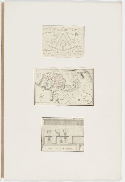
DR1974:0002:030:010:001-003
DR1974:0002:030:010:001-003
Personnes et institutions:
Sujet:
architecture, ingénierie, militaire, topographique
architecture, ingénierie, militaire, topographique
Date:
between 1800 and 1846
between 1800 and 1846
Titre:
Partial plan and sections of fortifications; Map of Rhodes; Plan of a battery
Actions:
DR1974:0002:030:010:001-003
Partial plan and sections of fortifications; Map of Rhodes; Plan of a battery
Actions:
DR1974:0002:030:010:001-003
Classification:
cartes, oeuvres d'art
cartes, oeuvres d'art
Date:
between 1800 and 1846
between 1800 and 1846
Personnes et institutions:
Sujet:
architecture, ingénierie, militaire, topographique
architecture, ingénierie, militaire, topographique
Classification:
cartes
cartes
Numéro de référence:
ARCH287017
ARCH287017
Personnes et institutions:
Date:
circa 1972
circa 1972
Classification:
cartes
cartes
Date:
circa 1972
circa 1972
Personnes et institutions: