


5773 Résultats
Classification:
dessins, documents textuels
dessins, documents textuels
Numéro de référence:
DR1995:0188:526-705
Description:
correspondence, architect's statement, proposals, building programme for Fun Palace Project, drafts of promotional material, clippings, report on Camden Pilot project, report on Fun Palace Project, notes on circulation, access, and systems, meeting notes, notes, minute of meetings of the Cybernetics Committee, draft articles with annotations, memoranda, draft survey, drafts and sketches of Fun Palace booklet, publications, cost estimate, sketch axonometric of service tower, brochures, questionnaires, certificate of incorporation for the Fun Palace, trust deeds, planning papers, application forms and site drawings of Children's Playground dated 1974, report on land redevelopment, and includes course outline dated 1980 for the Architectural Association
DR1995:0188:526-705
Description:
correspondence, architect's statement, proposals, building programme for Fun Palace Project, drafts of promotional material, clippings, report on Camden Pilot project, report on Fun Palace Project, notes on circulation, access, and systems, meeting notes, notes, minute of meetings of the Cybernetics Committee, draft articles with annotations, memoranda, draft survey, drafts and sketches of Fun Palace booklet, publications, cost estimate, sketch axonometric of service tower, brochures, questionnaires, certificate of incorporation for the Fun Palace, trust deeds, planning papers, application forms and site drawings of Children's Playground dated 1974, report on land redevelopment, and includes course outline dated 1980 for the Architectural Association
Personnes et institutions:
Titre:
Correspondence, architect's statement, proposals, building programme for Fun Palace Project
Actions:
DR1995:0188:526-705
Description:
correspondence, architect's statement, proposals, building programme for Fun Palace Project, drafts of promotional material, clippings, report on Camden Pilot project, report on Fun Palace Project, notes on circulation, access, and systems, meeting notes, notes, minute of meetings of the Cybernetics Committee, draft articles with annotations, memoranda, draft survey, drafts and sketches of Fun Palace booklet, publications, cost estimate, sketch axonometric of service tower, brochures, questionnaires, certificate of incorporation for the Fun Palace, trust deeds, planning papers, application forms and site drawings of Children's Playground dated 1974, report on land redevelopment, and includes course outline dated 1980 for the Architectural Association
Correspondence, architect's statement, proposals, building programme for Fun Palace Project
Actions:
DR1995:0188:526-705
Description:
correspondence, architect's statement, proposals, building programme for Fun Palace Project, drafts of promotional material, clippings, report on Camden Pilot project, report on Fun Palace Project, notes on circulation, access, and systems, meeting notes, notes, minute of meetings of the Cybernetics Committee, draft articles with annotations, memoranda, draft survey, drafts and sketches of Fun Palace booklet, publications, cost estimate, sketch axonometric of service tower, brochures, questionnaires, certificate of incorporation for the Fun Palace, trust deeds, planning papers, application forms and site drawings of Children's Playground dated 1974, report on land redevelopment, and includes course outline dated 1980 for the Architectural Association
Classification:
dessins, documents textuels
dessins, documents textuels
Personnes et institutions:
Actions:
Numéro de référence:
AP140.S2.SS7.D3.P10.9
Description:
- Includes segments from the Abend Shau, 6/7, the Landes Schau, and Heute Journal. - Also includes the film "Ein Stärkes Stuck" by Gisela Reich with narration by Walter Kreye.
AP140.S2.SS7.D3.P10.9
Description:
- Includes segments from the Abend Shau, 6/7, the Landes Schau, and Heute Journal. - Also includes the film "Ein Stärkes Stuck" by Gisela Reich with narration by Walter Kreye.
Personnes et institutions:
Date:
1984
1984
Titre:
German media coverage of the opening of the Staatsgalerie Stuttgart
Actions:
AP140.S2.SS7.D3.P10.9
Description:
- Includes segments from the Abend Shau, 6/7, the Landes Schau, and Heute Journal. - Also includes the film "Ein Stärkes Stuck" by Gisela Reich with narration by Walter Kreye.
German media coverage of the opening of the Staatsgalerie Stuttgart
Actions:
AP140.S2.SS7.D3.P10.9
Description:
- Includes segments from the Abend Shau, 6/7, the Landes Schau, and Heute Journal. - Also includes the film "Ein Stärkes Stuck" by Gisela Reich with narration by Walter Kreye.
Date:
1984
1984
Personnes et institutions:
Niveau de description archivistique:
Projet
Projet
Titre:
Potteries Thinkbelt
Potteries Thinkbelt
Numéro de référence:
AP144.S2.D56
Description:
File documents the unexecuted project, Potteries Thinkbelt, conceived for North Staffordshire, England, United Kingdom. The proposal called for a network of educational facilities for 20,000 students to be located over a 100 square mile area northwest of London. Moveable components, including fold-out lecture/demonstration units, rail-based teaching units, self-teach carrel units, faculty units, and housing units, were to be dispersed along the rail system. Existing conditions materials include regional aerial photographs with overlays of the rail system, and photographs, photo collages and panoramas of the region. Schematic sketches and drawings show the development of Price's design. Regional plans examine links between new and existing rail systems and national transportation networks and their projected use. Diagrammatic plans illustrate the relationships between recommended functions/activities attributed to specific areas. Detailed plans, sections, elevations, and axonometric drawings show housing types (sprawl, capsule, and crate), faculty and transfer areas in Madeley, Pitts Hill, and Meir. Other materials include regional land-use plans, photomontages with drawn perspectives, thumbnail sketches, life-span charts, conceptual sketches, aerial photographs and reprographic copies, some rendered and annotated. Many of the drawings were published in Price, Cedric. "PTB, Potteries Thinkbelt: A Plan for an Advanced Educational Industry in North Staffordshire." 'Architectural Design'. (October, 1966), 483-497; in Price, Cedric and Paul Barker, "The Potteries Thinkbelt", 'New Society' (June 1966) 14-17; and in Price, Cedric "Potteries Thinkbelt: Project for an Education Industry", 'Bauen & Wohnen', no. 9 (1967) 351-360. Material in this file was created between 1939 and 1987 but predominantly between 1963 and 1967. File contains conceptual drawings, design development drawings, presentation drawings, publication drawings, reference drawings, photographic material, and textual records.
AP144.S2.D56
Description:
File documents the unexecuted project, Potteries Thinkbelt, conceived for North Staffordshire, England, United Kingdom. The proposal called for a network of educational facilities for 20,000 students to be located over a 100 square mile area northwest of London. Moveable components, including fold-out lecture/demonstration units, rail-based teaching units, self-teach carrel units, faculty units, and housing units, were to be dispersed along the rail system. Existing conditions materials include regional aerial photographs with overlays of the rail system, and photographs, photo collages and panoramas of the region. Schematic sketches and drawings show the development of Price's design. Regional plans examine links between new and existing rail systems and national transportation networks and their projected use. Diagrammatic plans illustrate the relationships between recommended functions/activities attributed to specific areas. Detailed plans, sections, elevations, and axonometric drawings show housing types (sprawl, capsule, and crate), faculty and transfer areas in Madeley, Pitts Hill, and Meir. Other materials include regional land-use plans, photomontages with drawn perspectives, thumbnail sketches, life-span charts, conceptual sketches, aerial photographs and reprographic copies, some rendered and annotated. Many of the drawings were published in Price, Cedric. "PTB, Potteries Thinkbelt: A Plan for an Advanced Educational Industry in North Staffordshire." 'Architectural Design'. (October, 1966), 483-497; in Price, Cedric and Paul Barker, "The Potteries Thinkbelt", 'New Society' (June 1966) 14-17; and in Price, Cedric "Potteries Thinkbelt: Project for an Education Industry", 'Bauen & Wohnen', no. 9 (1967) 351-360. Material in this file was created between 1939 and 1987 but predominantly between 1963 and 1967. File contains conceptual drawings, design development drawings, presentation drawings, publication drawings, reference drawings, photographic material, and textual records.
Personnes et institutions:
Date:
1939-1987, predominant 1963-1967
1939-1987, predominant 1963-1967
Titre:
Potteries Thinkbelt
Actions:
AP144.S2.D56
Description:
File documents the unexecuted project, Potteries Thinkbelt, conceived for North Staffordshire, England, United Kingdom. The proposal called for a network of educational facilities for 20,000 students to be located over a 100 square mile area northwest of London. Moveable components, including fold-out lecture/demonstration units, rail-based teaching units, self-teach carrel units, faculty units, and housing units, were to be dispersed along the rail system. Existing conditions materials include regional aerial photographs with overlays of the rail system, and photographs, photo collages and panoramas of the region. Schematic sketches and drawings show the development of Price's design. Regional plans examine links between new and existing rail systems and national transportation networks and their projected use. Diagrammatic plans illustrate the relationships between recommended functions/activities attributed to specific areas. Detailed plans, sections, elevations, and axonometric drawings show housing types (sprawl, capsule, and crate), faculty and transfer areas in Madeley, Pitts Hill, and Meir. Other materials include regional land-use plans, photomontages with drawn perspectives, thumbnail sketches, life-span charts, conceptual sketches, aerial photographs and reprographic copies, some rendered and annotated. Many of the drawings were published in Price, Cedric. "PTB, Potteries Thinkbelt: A Plan for an Advanced Educational Industry in North Staffordshire." 'Architectural Design'. (October, 1966), 483-497; in Price, Cedric and Paul Barker, "The Potteries Thinkbelt", 'New Society' (June 1966) 14-17; and in Price, Cedric "Potteries Thinkbelt: Project for an Education Industry", 'Bauen & Wohnen', no. 9 (1967) 351-360. Material in this file was created between 1939 and 1987 but predominantly between 1963 and 1967. File contains conceptual drawings, design development drawings, presentation drawings, publication drawings, reference drawings, photographic material, and textual records.
Potteries Thinkbelt
Actions:
AP144.S2.D56
Description:
File documents the unexecuted project, Potteries Thinkbelt, conceived for North Staffordshire, England, United Kingdom. The proposal called for a network of educational facilities for 20,000 students to be located over a 100 square mile area northwest of London. Moveable components, including fold-out lecture/demonstration units, rail-based teaching units, self-teach carrel units, faculty units, and housing units, were to be dispersed along the rail system. Existing conditions materials include regional aerial photographs with overlays of the rail system, and photographs, photo collages and panoramas of the region. Schematic sketches and drawings show the development of Price's design. Regional plans examine links between new and existing rail systems and national transportation networks and their projected use. Diagrammatic plans illustrate the relationships between recommended functions/activities attributed to specific areas. Detailed plans, sections, elevations, and axonometric drawings show housing types (sprawl, capsule, and crate), faculty and transfer areas in Madeley, Pitts Hill, and Meir. Other materials include regional land-use plans, photomontages with drawn perspectives, thumbnail sketches, life-span charts, conceptual sketches, aerial photographs and reprographic copies, some rendered and annotated. Many of the drawings were published in Price, Cedric. "PTB, Potteries Thinkbelt: A Plan for an Advanced Educational Industry in North Staffordshire." 'Architectural Design'. (October, 1966), 483-497; in Price, Cedric and Paul Barker, "The Potteries Thinkbelt", 'New Society' (June 1966) 14-17; and in Price, Cedric "Potteries Thinkbelt: Project for an Education Industry", 'Bauen & Wohnen', no. 9 (1967) 351-360. Material in this file was created between 1939 and 1987 but predominantly between 1963 and 1967. File contains conceptual drawings, design development drawings, presentation drawings, publication drawings, reference drawings, photographic material, and textual records.
Niveau de description archivistique:
File 56
File 56
Date:
1939-1987, predominant 1963-1967
1939-1987, predominant 1963-1967
Personnes et institutions:
Classification:
photographies
photographies
Numéro de référence:
ARCH256302
Description:
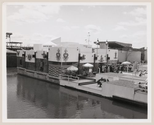
"Les éléments d'exposition du pavillon que la république de Haiti fait construire à l'Expo 67 illustreront le thème 'Haiti, terre de soleil'. L'édifice sera situé dans l'Ile Notre-Dame, à proximité des pavillons de Monaco et de la Yougoslavie. Il se reflétera dans deux des canaux de l'Expo. / The pavilion of the Republic of Haiti will stress the theme 'Haiti... land of the sun,' and will be located on Notre-Dame near the pavilions of Monaco and Yugoslavia. The pavilion's floor and external terrace will be a checkered motif stylizing the sun, while the roof will be made of 16 hollow tubes of varying heights. Total cost of the pavilion will be approximately $150,000.00."--Description.
ARCH256302
Description:
"Les éléments d'exposition du pavillon que la république de Haiti fait construire à l'Expo 67 illustreront le thème 'Haiti, terre de soleil'. L'édifice sera situé dans l'Ile Notre-Dame, à proximité des pavillons de Monaco et de la Yougoslavie. Il se reflétera dans deux des canaux de l'Expo. / The pavilion of the Republic of Haiti will stress the theme 'Haiti... land of the sun,' and will be located on Notre-Dame near the pavilions of Monaco and Yugoslavia. The pavilion's floor and external terrace will be a checkered motif stylizing the sun, while the roof will be made of 16 hollow tubes of varying heights. Total cost of the pavilion will be approximately $150,000.00."--Description.
Personnes et institutions:
Date:
1967
1967
Titre:
View of the Pavilion of Haiti, Expo 67, Montréal, Québec
Actions:
ARCH256302
Description:
"Les éléments d'exposition du pavillon que la république de Haiti fait construire à l'Expo 67 illustreront le thème 'Haiti, terre de soleil'. L'édifice sera situé dans l'Ile Notre-Dame, à proximité des pavillons de Monaco et de la Yougoslavie. Il se reflétera dans deux des canaux de l'Expo. / The pavilion of the Republic of Haiti will stress the theme 'Haiti... land of the sun,' and will be located on Notre-Dame near the pavilions of Monaco and Yugoslavia. The pavilion's floor and external terrace will be a checkered motif stylizing the sun, while the roof will be made of 16 hollow tubes of varying heights. Total cost of the pavilion will be approximately $150,000.00."--Description.
View of the Pavilion of Haiti, Expo 67, Montréal, Québec
Actions:
ARCH256302
Description:
"Les éléments d'exposition du pavillon que la république de Haiti fait construire à l'Expo 67 illustreront le thème 'Haiti, terre de soleil'. L'édifice sera situé dans l'Ile Notre-Dame, à proximité des pavillons de Monaco et de la Yougoslavie. Il se reflétera dans deux des canaux de l'Expo. / The pavilion of the Republic of Haiti will stress the theme 'Haiti... land of the sun,' and will be located on Notre-Dame near the pavilions of Monaco and Yugoslavia. The pavilion's floor and external terrace will be a checkered motif stylizing the sun, while the roof will be made of 16 hollow tubes of varying heights. Total cost of the pavilion will be approximately $150,000.00."--Description.
Classification:
photographies
photographies
Date:
1967
1967
Personnes et institutions:
Classification:
expositions
expositions
Actions:
Description:
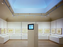
*Montréal, ville fortifiée du XVIIIe siècle* explore l’évolution de la ville au XVIIIe siècle, alors qu’elle était une ville fortifiée. Cet événement offre une occasion unique de se renseigner sur l’essor de la ville commerciale et militaire à l’origine de la métropole actuelle. Couronnant presque quinze années de recherche et la création d’une(...)
*Montréal, ville fortifiée du XVIIIe siècle* explore l’évolution de la ville au XVIIIe siècle, alors qu’elle était une ville fortifiée. Cet événement offre une occasion unique de se renseigner sur l’essor de la ville commerciale et militaire à l’origine de la métropole actuelle. Couronnant presque quinze années de recherche et la création d’une(...)
Localisation:
Salles principales
Salles principales
Date:
8 septembre 1992 au 28 février 1993
8 septembre 1992 au 28 février 1993
Titre:
Montréal, ville fortifiée au XVIIIe siècle
Actions:
Description:
*Montréal, ville fortifiée du XVIIIe siècle* explore l’évolution de la ville au XVIIIe siècle, alors qu’elle était une ville fortifiée. Cet événement offre une occasion unique de se renseigner sur l’essor de la ville commerciale et militaire à l’origine de la métropole actuelle. Couronnant presque quinze années de recherche et la création d’une(...)
Montréal, ville fortifiée au XVIIIe siècle
Actions:
Description:
*Montréal, ville fortifiée du XVIIIe siècle* explore l’évolution de la ville au XVIIIe siècle, alors qu’elle était une ville fortifiée. Cet événement offre une occasion unique de se renseigner sur l’essor de la ville commerciale et militaire à l’origine de la métropole actuelle. Couronnant presque quinze années de recherche et la création d’une(...)
Classification:
expositions
expositions
Date:
8 septembre 1992 au
28 février 1993
8 septembre 1992 au
28 février 1993
Localisation:
Salles principales
Salles principales
Classification:
événements
événements
Titre:
L’enseignement de… Bahreïn
L’enseignement de… Bahreïn
Actions:
Description:
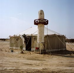
Noura al Sayeh présente la troisième conférence de la série L’enseignement du… Moyen-Orient. La présentation portera sur la documentation photographique de la côte de Bahreïn par le photographe Camille Zakharia. Les transformations des 30 dernières années ont redessiné le paysage urbain bahreïni et entraîné le développement d’une culture vernaculaire contemporaine. On y(...)
Noura al Sayeh présente la troisième conférence de la série L’enseignement du… Moyen-Orient. La présentation portera sur la documentation photographique de la côte de Bahreïn par le photographe Camille Zakharia. Les transformations des 30 dernières années ont redessiné le paysage urbain bahreïni et entraîné le développement d’une culture vernaculaire contemporaine. On y(...)
Localisation:
Théâtre Paul-Desmarais
Théâtre Paul-Desmarais
Date:
6 octobre 2011 , 19h
6 octobre 2011 , 19h
Titre:
L’enseignement de… Bahreïn
Actions:
Description:
Noura al Sayeh présente la troisième conférence de la série L’enseignement du… Moyen-Orient. La présentation portera sur la documentation photographique de la côte de Bahreïn par le photographe Camille Zakharia. Les transformations des 30 dernières années ont redessiné le paysage urbain bahreïni et entraîné le développement d’une culture vernaculaire contemporaine. On y(...)
L’enseignement de… Bahreïn
Actions:
Description:
Noura al Sayeh présente la troisième conférence de la série L’enseignement du… Moyen-Orient. La présentation portera sur la documentation photographique de la côte de Bahreïn par le photographe Camille Zakharia. Les transformations des 30 dernières années ont redessiné le paysage urbain bahreïni et entraîné le développement d’une culture vernaculaire contemporaine. On y(...)
Classification:
événements
événements
Date:
6 octobre 2011
19h
6 octobre 2011
19h
Localisation:
Théâtre Paul-Desmarais
Théâtre Paul-Desmarais
Classification:
documents textuels
documents textuels
Numéro de référence:
ARCH255577
Description:
20 publications including: Tall building structure: a world view / Council on Tall Buildings and Urban Habitat; Bauwelt 6 Aug. 1962 Hugo Weber: Mies van der Rohe; L'architettura July-Aug. 1955 annotated in graphite "M.G. Thesis"; Bauen & Wohnen July 1972; Arts & Architecture Nov. 1956; Western Architect & Engineer Feb. 1961; Architectural Forum Feb. 1959, June 1959, April 1961 and May 1962; Polytechnisch Tydschrift 12 Sept. 1957; Architectural Review Oct. 1977; Architectural Record Oct. 1960; Document Architettura v.1 no.14; Casabella Jan-Feb 1988; Columus Indiana: central area plan; Elkhart Indiana: Comprehensive plan for parks, recreation and open land; Elkhat Indiana: central area plan; Mauna City: a city within a city
ARCH255577
Description:
20 publications including: Tall building structure: a world view / Council on Tall Buildings and Urban Habitat; Bauwelt 6 Aug. 1962 Hugo Weber: Mies van der Rohe; L'architettura July-Aug. 1955 annotated in graphite "M.G. Thesis"; Bauen & Wohnen July 1972; Arts & Architecture Nov. 1956; Western Architect & Engineer Feb. 1961; Architectural Forum Feb. 1959, June 1959, April 1961 and May 1962; Polytechnisch Tydschrift 12 Sept. 1957; Architectural Review Oct. 1977; Architectural Record Oct. 1960; Document Architettura v.1 no.14; Casabella Jan-Feb 1988; Columus Indiana: central area plan; Elkhart Indiana: Comprehensive plan for parks, recreation and open land; Elkhat Indiana: central area plan; Mauna City: a city within a city
Personnes et institutions:
Date:
1951-1966
1951-1966
Titre:
Misc. publications and magazines of architecture
Actions:
ARCH255577
Description:
20 publications including: Tall building structure: a world view / Council on Tall Buildings and Urban Habitat; Bauwelt 6 Aug. 1962 Hugo Weber: Mies van der Rohe; L'architettura July-Aug. 1955 annotated in graphite "M.G. Thesis"; Bauen & Wohnen July 1972; Arts & Architecture Nov. 1956; Western Architect & Engineer Feb. 1961; Architectural Forum Feb. 1959, June 1959, April 1961 and May 1962; Polytechnisch Tydschrift 12 Sept. 1957; Architectural Review Oct. 1977; Architectural Record Oct. 1960; Document Architettura v.1 no.14; Casabella Jan-Feb 1988; Columus Indiana: central area plan; Elkhart Indiana: Comprehensive plan for parks, recreation and open land; Elkhat Indiana: central area plan; Mauna City: a city within a city
Misc. publications and magazines of architecture
Actions:
ARCH255577
Description:
20 publications including: Tall building structure: a world view / Council on Tall Buildings and Urban Habitat; Bauwelt 6 Aug. 1962 Hugo Weber: Mies van der Rohe; L'architettura July-Aug. 1955 annotated in graphite "M.G. Thesis"; Bauen & Wohnen July 1972; Arts & Architecture Nov. 1956; Western Architect & Engineer Feb. 1961; Architectural Forum Feb. 1959, June 1959, April 1961 and May 1962; Polytechnisch Tydschrift 12 Sept. 1957; Architectural Review Oct. 1977; Architectural Record Oct. 1960; Document Architettura v.1 no.14; Casabella Jan-Feb 1988; Columus Indiana: central area plan; Elkhart Indiana: Comprehensive plan for parks, recreation and open land; Elkhat Indiana: central area plan; Mauna City: a city within a city
Classification:
documents textuels
documents textuels
Date:
1951-1966
1951-1966
Personnes et institutions:
Classification:
événements
événements
Actions:
Description:
Yasser Elsheshtawy présente la deuxième conférence de la série L’enseignement du… Moyen-Orient.Si l’on présente souvent Dubaï comme un terrain de jeu pour les privilégiés, un lieu de consommation à outrance parfaitement assumé ou un cas d’étude par excellence de l’exploitation capitaliste, de tels portraits ne montrent finalement qu’une seule facette de la ville. La(...)
Yasser Elsheshtawy présente la deuxième conférence de la série L’enseignement du… Moyen-Orient.Si l’on présente souvent Dubaï comme un terrain de jeu pour les privilégiés, un lieu de consommation à outrance parfaitement assumé ou un cas d’étude par excellence de l’exploitation capitaliste, de tels portraits ne montrent finalement qu’une seule facette de la ville. La(...)
Localisation:
Théâtre Paul-Desmarais
Théâtre Paul-Desmarais
Date:
29 septembre 2011 , 19h
29 septembre 2011 , 19h
Titre:
L'enseignement de... Dubaï : Yasser Elsheshtawy
Actions:
Description:
Yasser Elsheshtawy présente la deuxième conférence de la série L’enseignement du… Moyen-Orient.Si l’on présente souvent Dubaï comme un terrain de jeu pour les privilégiés, un lieu de consommation à outrance parfaitement assumé ou un cas d’étude par excellence de l’exploitation capitaliste, de tels portraits ne montrent finalement qu’une seule facette de la ville. La(...)
L'enseignement de... Dubaï : Yasser Elsheshtawy
Actions:
Description:
Yasser Elsheshtawy présente la deuxième conférence de la série L’enseignement du… Moyen-Orient.Si l’on présente souvent Dubaï comme un terrain de jeu pour les privilégiés, un lieu de consommation à outrance parfaitement assumé ou un cas d’étude par excellence de l’exploitation capitaliste, de tels portraits ne montrent finalement qu’une seule facette de la ville. La(...)
Classification:
événements
événements
Date:
29 septembre 2011
19h
29 septembre 2011
19h
Localisation:
Théâtre Paul-Desmarais
Théâtre Paul-Desmarais
Niveau de description archivistique:
Projet
Projet
Numéro de référence:
AP206.S1.1975.PR01
Description:
This project series documents Aditya Prakash's proposal for an alternative plan for Chandigarh, India, which came to be known as the Linear City. Prakash began developing and advocating for this idea around the early 1970s. The Linear City had two fundamental ideas at its core. The first was to raise the roadways in Chandigarh (or any future city) 10-12 feet from ground level. This, he proposed, would separate vehicular traffic from pedestrians, eliminating all the hazardous impacts of traffic on daily life. The large part of the drawings for this project show sector plans and city blocks with evenly dispersed roundabout roadways as major transit hubs, wrapping around but high above centres of pedestrian activity that included shops, markets and green spaces. The sale of the land below the roadways would pay for the upheaval. He also recommended building this city only a few sectors deep, but endlessly expanding it length-wise, with a raised canal along one side to provide an additional transportation network and irrigation. The second fundamental idea of this city was the creation of self-sustaining sectors in the city plan, advocating that each neighbourhood should have the infrastructure to provide food and recycling for its residents. He fervently argued for the reimagination of modernist Chandigarh by incorporating sustainable, local traditions - the rural should exist in harmony with the urban. In opposition to Le Corbusier and Pierre Jeanneret, he believed areas for recycling, animal husbandry, and growing food should be incorporated into the fabric of the city.[1] This project is recorded largely through original drawings of city plans, perspectives and axonometric views detailing Prakash's new vision for the city. It seems that many of the perspectives were drawn by family friend Sandeep Virmani, after listening to Prakash's ideas.[2] The project is also recorded through photographs, negatives and slides showing plans and the project model. A small amount of notes and an article on the project are also included. [1]Vikramaditya Prakash, One Continuous Line: Art, Architecture and Urbanism of Aditya Prakash (Ahmedabad, India: Mapin Publishing Pvt. Ltd., 2019), 164-181. [2]Prakash, One Continuous Line, 169.
AP206.S1.1975.PR01
Description:
This project series documents Aditya Prakash's proposal for an alternative plan for Chandigarh, India, which came to be known as the Linear City. Prakash began developing and advocating for this idea around the early 1970s. The Linear City had two fundamental ideas at its core. The first was to raise the roadways in Chandigarh (or any future city) 10-12 feet from ground level. This, he proposed, would separate vehicular traffic from pedestrians, eliminating all the hazardous impacts of traffic on daily life. The large part of the drawings for this project show sector plans and city blocks with evenly dispersed roundabout roadways as major transit hubs, wrapping around but high above centres of pedestrian activity that included shops, markets and green spaces. The sale of the land below the roadways would pay for the upheaval. He also recommended building this city only a few sectors deep, but endlessly expanding it length-wise, with a raised canal along one side to provide an additional transportation network and irrigation. The second fundamental idea of this city was the creation of self-sustaining sectors in the city plan, advocating that each neighbourhood should have the infrastructure to provide food and recycling for its residents. He fervently argued for the reimagination of modernist Chandigarh by incorporating sustainable, local traditions - the rural should exist in harmony with the urban. In opposition to Le Corbusier and Pierre Jeanneret, he believed areas for recycling, animal husbandry, and growing food should be incorporated into the fabric of the city.[1] This project is recorded largely through original drawings of city plans, perspectives and axonometric views detailing Prakash's new vision for the city. It seems that many of the perspectives were drawn by family friend Sandeep Virmani, after listening to Prakash's ideas.[2] The project is also recorded through photographs, negatives and slides showing plans and the project model. A small amount of notes and an article on the project are also included. [1]Vikramaditya Prakash, One Continuous Line: Art, Architecture and Urbanism of Aditya Prakash (Ahmedabad, India: Mapin Publishing Pvt. Ltd., 2019), 164-181. [2]Prakash, One Continuous Line, 169.
Personnes et institutions:
Date:
circa 1975-2003
circa 1975-2003
Titre:
Linear city, Chandigarh, India (circa 1975-1987)
Actions:
AP206.S1.1975.PR01
Description:
This project series documents Aditya Prakash's proposal for an alternative plan for Chandigarh, India, which came to be known as the Linear City. Prakash began developing and advocating for this idea around the early 1970s. The Linear City had two fundamental ideas at its core. The first was to raise the roadways in Chandigarh (or any future city) 10-12 feet from ground level. This, he proposed, would separate vehicular traffic from pedestrians, eliminating all the hazardous impacts of traffic on daily life. The large part of the drawings for this project show sector plans and city blocks with evenly dispersed roundabout roadways as major transit hubs, wrapping around but high above centres of pedestrian activity that included shops, markets and green spaces. The sale of the land below the roadways would pay for the upheaval. He also recommended building this city only a few sectors deep, but endlessly expanding it length-wise, with a raised canal along one side to provide an additional transportation network and irrigation. The second fundamental idea of this city was the creation of self-sustaining sectors in the city plan, advocating that each neighbourhood should have the infrastructure to provide food and recycling for its residents. He fervently argued for the reimagination of modernist Chandigarh by incorporating sustainable, local traditions - the rural should exist in harmony with the urban. In opposition to Le Corbusier and Pierre Jeanneret, he believed areas for recycling, animal husbandry, and growing food should be incorporated into the fabric of the city.[1] This project is recorded largely through original drawings of city plans, perspectives and axonometric views detailing Prakash's new vision for the city. It seems that many of the perspectives were drawn by family friend Sandeep Virmani, after listening to Prakash's ideas.[2] The project is also recorded through photographs, negatives and slides showing plans and the project model. A small amount of notes and an article on the project are also included. [1]Vikramaditya Prakash, One Continuous Line: Art, Architecture and Urbanism of Aditya Prakash (Ahmedabad, India: Mapin Publishing Pvt. Ltd., 2019), 164-181. [2]Prakash, One Continuous Line, 169.
Linear city, Chandigarh, India (circa 1975-1987)
Actions:
AP206.S1.1975.PR01
Description:
This project series documents Aditya Prakash's proposal for an alternative plan for Chandigarh, India, which came to be known as the Linear City. Prakash began developing and advocating for this idea around the early 1970s. The Linear City had two fundamental ideas at its core. The first was to raise the roadways in Chandigarh (or any future city) 10-12 feet from ground level. This, he proposed, would separate vehicular traffic from pedestrians, eliminating all the hazardous impacts of traffic on daily life. The large part of the drawings for this project show sector plans and city blocks with evenly dispersed roundabout roadways as major transit hubs, wrapping around but high above centres of pedestrian activity that included shops, markets and green spaces. The sale of the land below the roadways would pay for the upheaval. He also recommended building this city only a few sectors deep, but endlessly expanding it length-wise, with a raised canal along one side to provide an additional transportation network and irrigation. The second fundamental idea of this city was the creation of self-sustaining sectors in the city plan, advocating that each neighbourhood should have the infrastructure to provide food and recycling for its residents. He fervently argued for the reimagination of modernist Chandigarh by incorporating sustainable, local traditions - the rural should exist in harmony with the urban. In opposition to Le Corbusier and Pierre Jeanneret, he believed areas for recycling, animal husbandry, and growing food should be incorporated into the fabric of the city.[1] This project is recorded largely through original drawings of city plans, perspectives and axonometric views detailing Prakash's new vision for the city. It seems that many of the perspectives were drawn by family friend Sandeep Virmani, after listening to Prakash's ideas.[2] The project is also recorded through photographs, negatives and slides showing plans and the project model. A small amount of notes and an article on the project are also included. [1]Vikramaditya Prakash, One Continuous Line: Art, Architecture and Urbanism of Aditya Prakash (Ahmedabad, India: Mapin Publishing Pvt. Ltd., 2019), 164-181. [2]Prakash, One Continuous Line, 169.
Niveau de description archivistique:
Project
Project
Date:
circa 1975-2003
circa 1975-2003
Personnes et institutions:
Classification:
dessins
dessins
Actions:
Numéro de référence:
DR1985:0415
Description:
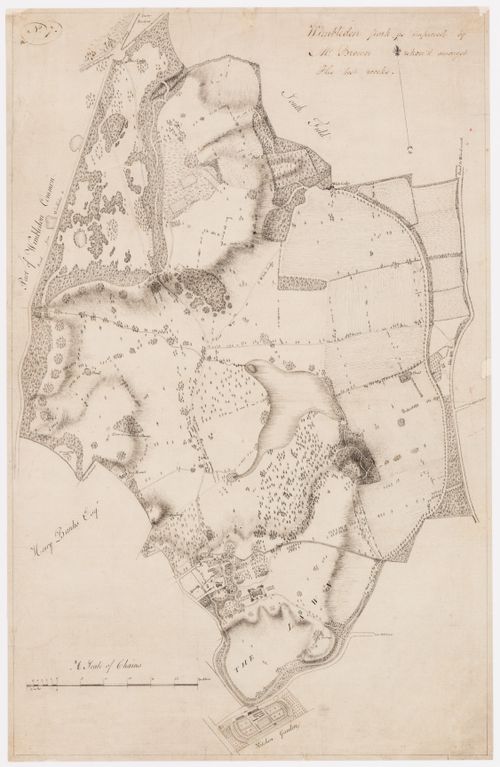
- DR1985:0415 presents a cartographic survey of Wimbledon Park as "improved" in the second half of the eighteenth century. Covering some 1,200 acres, the park as shown in this plan contains all the elements of Capability Brown's mature landscape style: expanses of grass traversed by meandering paths, irregular plantings of trees placed singly and in clumps, and winding streams dammed to create a large, irregular lake near the centre of the property and several small ponds about the periphery. The main house (built 1732-33 for Sarah, the Duchess of Marlborough), its outbuildings, and the village church are shown at the southern end of the park, as is a kitchen garden dating from an earlier period. Roads, lanes, and neighbouring properties are neatly labelled in the draughtsman's hand, and the fall of the land has been indicated in shade lines.
DR1985:0415
Description:
- DR1985:0415 presents a cartographic survey of Wimbledon Park as "improved" in the second half of the eighteenth century. Covering some 1,200 acres, the park as shown in this plan contains all the elements of Capability Brown's mature landscape style: expanses of grass traversed by meandering paths, irregular plantings of trees placed singly and in clumps, and winding streams dammed to create a large, irregular lake near the centre of the property and several small ponds about the periphery. The main house (built 1732-33 for Sarah, the Duchess of Marlborough), its outbuildings, and the village church are shown at the southern end of the park, as is a kitchen garden dating from an earlier period. Roads, lanes, and neighbouring properties are neatly labelled in the draughtsman's hand, and the fall of the land has been indicated in shade lines.
Personnes et institutions:
Sujet:
architecture de paysage, topographique
architecture de paysage, topographique
Date:
between 1765 and 1785
between 1765 and 1785
Titre:
A survey plan of Wimbledon Park as designed for Lord Spencer by Capability Brown
Actions:
DR1985:0415
Description:
- DR1985:0415 presents a cartographic survey of Wimbledon Park as "improved" in the second half of the eighteenth century. Covering some 1,200 acres, the park as shown in this plan contains all the elements of Capability Brown's mature landscape style: expanses of grass traversed by meandering paths, irregular plantings of trees placed singly and in clumps, and winding streams dammed to create a large, irregular lake near the centre of the property and several small ponds about the periphery. The main house (built 1732-33 for Sarah, the Duchess of Marlborough), its outbuildings, and the village church are shown at the southern end of the park, as is a kitchen garden dating from an earlier period. Roads, lanes, and neighbouring properties are neatly labelled in the draughtsman's hand, and the fall of the land has been indicated in shade lines.
A survey plan of Wimbledon Park as designed for Lord Spencer by Capability Brown
Actions:
DR1985:0415
Description:
- DR1985:0415 presents a cartographic survey of Wimbledon Park as "improved" in the second half of the eighteenth century. Covering some 1,200 acres, the park as shown in this plan contains all the elements of Capability Brown's mature landscape style: expanses of grass traversed by meandering paths, irregular plantings of trees placed singly and in clumps, and winding streams dammed to create a large, irregular lake near the centre of the property and several small ponds about the periphery. The main house (built 1732-33 for Sarah, the Duchess of Marlborough), its outbuildings, and the village church are shown at the southern end of the park, as is a kitchen garden dating from an earlier period. Roads, lanes, and neighbouring properties are neatly labelled in the draughtsman's hand, and the fall of the land has been indicated in shade lines.
Classification:
dessins
dessins
Date:
between 1765 and 1785
between 1765 and 1785
Personnes et institutions:
Sujet:
architecture de paysage, topographique
architecture de paysage, topographique


