35106 Résultats
Classification:
cartes, dessins, oeuvres d'art
cartes, dessins, oeuvres d'art
Actions:
Numéro de référence:
DR1974:0002:030:009:001-003
DR1974:0002:030:009:001-003
Personnes et institutions:
Sujet:
architecture, topographique
architecture, topographique
Date:
printed between 1800 and 1846
printed between 1800 and 1846
Titre:
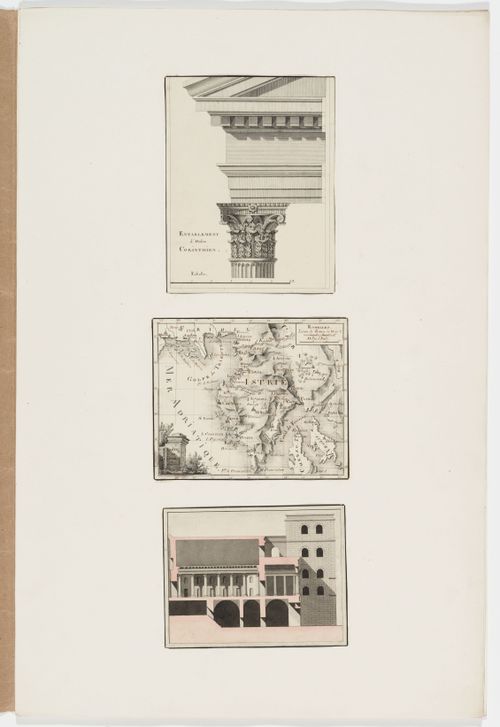
Elevation of a Corinthian capital and entablature; Map of Istria; Sectional elevation of an unidentified building
Actions:
DR1974:0002:030:009:001-003
Elevation of a Corinthian capital and entablature; Map of Istria; Sectional elevation of an unidentified building
Actions:
DR1974:0002:030:009:001-003
Classification:
cartes, dessins, oeuvres d'art
cartes, dessins, oeuvres d'art
Date:
printed between 1800 and 1846
printed between 1800 and 1846
Personnes et institutions:
Sujet:
architecture, topographique
architecture, topographique
Classification:
dessins
dessins
Numéro de référence:
DR2004:0779
DR2004:0779
Personnes et institutions:
Classification:
dessins
dessins
Personnes et institutions:
Classification:
cartes, photographies
cartes, photographies
Numéro de référence:
DR1987:0420
DR1987:0420
Personnes et institutions:
Sujet:
topographique
topographique
Date:
printed 1950s
printed 1950s
Classification:
cartes, photographies
cartes, photographies
Date:
printed 1950s
printed 1950s
Personnes et institutions:
Sujet:
topographique
topographique
Classification:
dessins
Quantité:
15 working drawing(s)
dessins
Quantité:
15 working drawing(s)
Numéro de référence:
ARCH252875
ARCH252875
Personnes et institutions:
Classification:
dessins
Quantité:
15 working drawing(s)
dessins
Quantité:
15 working drawing(s)
Personnes et institutions:
Classification:
dessins
Quantité:
5 working drawing(s)
dessins
Quantité:
5 working drawing(s)
Numéro de référence:
ARCH186015
ARCH186015
Personnes et institutions:
Classification:
dessins
Quantité:
5 working drawing(s)
dessins
Quantité:
5 working drawing(s)
Personnes et institutions:
Classification:
dessins
Quantité:
3 File
dessins
Quantité:
3 File
Numéro de référence:
ARCH44434
ARCH44434
Personnes et institutions:
Classification:
dessins
Quantité:
3 File
dessins
Quantité:
3 File
Personnes et institutions:
Classification:
dessins
dessins
Numéro de référence:
DR2004:0932:006
DR2004:0932:006
Personnes et institutions:
Date:
1990
1990
Classification:
dessins
dessins
Date:
1990
1990
Personnes et institutions:
Classification:
cartes, dessins
cartes, dessins
Numéro de référence:
ARCH400736
ARCH400736
Personnes et institutions:
Date:
1962
1962
Classification:
cartes, dessins
cartes, dessins
Date:
1962
1962
Personnes et institutions:
Classification:
dessins
dessins
Numéro de référence:
AP046.S1.1983.PR02.020
Description:
This file includes a drawing in three pieces which join at the "trim line".
AP046.S1.1983.PR02.020
Description:
This file includes a drawing in three pieces which join at the "trim line".
Personnes et institutions:
Date:
1983-1992
1983-1992
Titre:
Topographic map for Place Jacques Cartier, Old Port of Montreal Master Plan, Montréal, Québec
Actions:
AP046.S1.1983.PR02.020
Description:
This file includes a drawing in three pieces which join at the "trim line".
Topographic map for Place Jacques Cartier, Old Port of Montreal Master Plan, Montréal, Québec
Actions:
AP046.S1.1983.PR02.020
Description:
This file includes a drawing in three pieces which join at the "trim line".
Classification:
dessins
dessins
Date:
1983-1992
1983-1992
Personnes et institutions:
Classification:
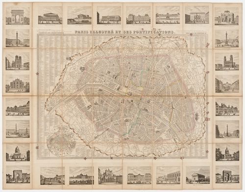
cartes, oeuvres d'art
cartes, oeuvres d'art
Actions:
Numéro de référence:
DR1999:0006
DR1999:0006
Personnes et institutions:
Sujet:
militaire, urbanisme
militaire, urbanisme
Date:
1853
1853
Classification:
cartes, oeuvres d'art
cartes, oeuvres d'art
Date:
1853
1853
Personnes et institutions:
Sujet:
militaire, urbanisme
militaire, urbanisme