950 Résultats
Classification:
dessins
dessins
Actions:
Numéro de référence:
DR1987:0378 R/V
Description:
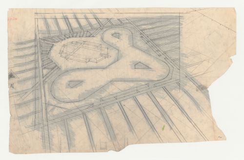
- This drawing shows the major boundaries of the site and buildings for Los Angeles Municipal Airport. The boundry lines have been rubbed with graphite on the verso in preparation for transfer. There are a few small sketches around the perimeter of the drawing.
DR1987:0378 R/V
Description:
- This drawing shows the major boundaries of the site and buildings for Los Angeles Municipal Airport. The boundry lines have been rubbed with graphite on the verso in preparation for transfer. There are a few small sketches around the perimeter of the drawing.
Personnes et institutions:
Sujet:
architecture
architecture
Date:
1929
1929
Titre:
Los Angeles Municipal Airport: Preliminary bird's-eye perspective
Actions:
DR1987:0378 R/V
Description:
- This drawing shows the major boundaries of the site and buildings for Los Angeles Municipal Airport. The boundry lines have been rubbed with graphite on the verso in preparation for transfer. There are a few small sketches around the perimeter of the drawing.
Classification:
dessins
dessins
Date:
1929
1929
Personnes et institutions:
Sujet:
architecture
architecture
Classification:
articles
articles
Titre:
Fictions de fictions
Fictions de fictions
Actions:
Piper Bernbaum sur les réalités physiques et les fictions juridiques de l’érouv à Jérusalem
Titre:
Fictions de fictions
Piper Bernbaum sur les réalités physiques et les fictions juridiques de l’érouv à Jérusalem
Actions:
Fictions de fictions
Piper Bernbaum sur les réalités physiques et les fictions juridiques de l’érouv à Jérusalem
Actions:
Dossier:
Figurer un territoire
Figurer un territoire
Classification:
archives
Niveau de description archivistique:
Fonds
archives
Niveau de description archivistique:
Fonds
Numéro de référence:
AP051
Résumé:
The Groupe de recherche sur Montréal fonds, 1975-1997, documents the Groupe de recherche sur Montréal’s (GRM) extensive research on the development of pre and post-industrial Montreal’s built environment. In addition to this extensive collection of research materials, the fonds also includes administrative files relating to the GRM’s everyday administration and management. Materials found in this fonds consist of approximately 40 l.m. of textual documentation, approximately 2000 maps and 1 model.
Personnes et institutions:
Date:
1975-1997
1975-1997
Titre:
Fonds Groupe de recherche sur Montréal
Actions:
AP051
Résumé:
The Groupe de recherche sur Montréal fonds, 1975-1997, documents the Groupe de recherche sur Montréal’s (GRM) extensive research on the development of pre and post-industrial Montreal’s built environment. In addition to this extensive collection of research materials, the fonds also includes administrative files relating to the GRM’s everyday administration and management. Materials found in this fonds consist of approximately 40 l.m. of textual documentation, approximately 2000 maps and 1 model.
Classification:
archives
Niveau de description archivistique:
Fonds
archives
Niveau de description archivistique:
Fonds
Date:
1975-1997
1975-1997
Personnes et institutions:
Classification:
dessins
dessins
Numéro de référence:
DR1987:0463
Description:
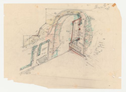
- This site plan for Swedenborg Memorial Chapel, El Cerrito, California, includes the major components of the project, such as the chapel, parking lot, recreation field and associated buildings. The site boundaries are indicated only where necessary to delineate lot subdivisions. Coloured shading distinguishes separate areas of the site, possibly for grading purposes.
DR1987:0463
Description:
- This site plan for Swedenborg Memorial Chapel, El Cerrito, California, includes the major components of the project, such as the chapel, parking lot, recreation field and associated buildings. The site boundaries are indicated only where necessary to delineate lot subdivisions. Coloured shading distinguishes separate areas of the site, possibly for grading purposes.
Personnes et institutions:
Sujet:
architecture
architecture
Date:
between 1955 and 1962
between 1955 and 1962
Titre:
Swedenborg Memorial Chapel, El Cerrito, California: Partial site plan showing lot subdivision, recreation field, access road and subdivisions
Actions:
DR1987:0463
Description:
- This site plan for Swedenborg Memorial Chapel, El Cerrito, California, includes the major components of the project, such as the chapel, parking lot, recreation field and associated buildings. The site boundaries are indicated only where necessary to delineate lot subdivisions. Coloured shading distinguishes separate areas of the site, possibly for grading purposes.
Classification:
dessins
dessins
Date:
between 1955 and 1962
between 1955 and 1962
Personnes et institutions:
Sujet:
architecture
architecture
Classification:
événements
événements

Titre:
Devices of Design
Devices of Design
Actions:
Description:
Le colloque Devices of Design est une collaboration entre le CCA et la Fondation Daniel Langlois pour l’art, la science et la technologie. Il a été organisé en réponse à l’utilisation de plus en plus massive des outils numériques et des nouvelles technologies dans la conception architecturale et dans le domaine de la construction. Diverses communications ainsi qu’une(...)
Le colloque Devices of Design est une collaboration entre le CCA et la Fondation Daniel Langlois pour l’art, la science et la technologie. Il a été organisé en réponse à l’utilisation de plus en plus massive des outils numériques et des nouvelles technologies dans la conception architecturale et dans le domaine de la construction. Diverses communications ainsi qu’une(...)
Localisation:
Théâtre Paul-Desmarais
Théâtre Paul-Desmarais
Date:
18 novembre 2004 au 19 novembre 2004
18 novembre 2004 au 19 novembre 2004
Titre:
Devices of Design
Actions:
Description:
Le colloque Devices of Design est une collaboration entre le CCA et la Fondation Daniel Langlois pour l’art, la science et la technologie. Il a été organisé en réponse à l’utilisation de plus en plus massive des outils numériques et des nouvelles technologies dans la conception architecturale et dans le domaine de la construction. Diverses communications ainsi qu’une(...)
Classification:
événements
événements
Date:
18 novembre 2004 au
19 novembre 2004
18 novembre 2004 au
19 novembre 2004
Localisation:
Théâtre Paul-Desmarais
Théâtre Paul-Desmarais
Numéro de référence:
PH1979:0634:001-035
Description:
Album showing 35 captioned photographs of views in the Cypress Hills Cemetery in Long Island, New York, taken by the Pach (for Pach Brothers) photographic studio, located at 858 Broadway, NY. This first nonsectarian cemetery corporation was established in 1848. Within the boundaries of the Cypress Hills Cemetery, a large private cemetery in Brooklyn, a section of it was designated as the Cypress Hills National Cemetery in 1862, a military burial ground for soldiers of the American Civil War. The views in this album show the South Entrance to the Cypress Hills Cemetery, the Soldiers' Grounds "National Cemetery", the Delta Lake, the grounds of Ahawath Chesed Congregation and several memorials and tombstones in the cemetery.
Personnes et institutions:
Sujet:
ornement
ornement
Date:
ca. 1875?
ca. 1875?
Titre:
Views in Cypress Hills Cemetery, Long Island New-York [sic]
Actions:
PH1979:0634:001-035
Description:
Album showing 35 captioned photographs of views in the Cypress Hills Cemetery in Long Island, New York, taken by the Pach (for Pach Brothers) photographic studio, located at 858 Broadway, NY. This first nonsectarian cemetery corporation was established in 1848. Within the boundaries of the Cypress Hills Cemetery, a large private cemetery in Brooklyn, a section of it was designated as the Cypress Hills National Cemetery in 1862, a military burial ground for soldiers of the American Civil War. The views in this album show the South Entrance to the Cypress Hills Cemetery, the Soldiers' Grounds "National Cemetery", the Delta Lake, the grounds of Ahawath Chesed Congregation and several memorials and tombstones in the cemetery.
Date:
ca. 1875?
ca. 1875?
Personnes et institutions:
Sujet:
ornement
ornement
Classification:
événements
événements
Actions:
Description:
Arturo Ortiz Struck décrit les frontières de la construction légale et autorisée dans le contexte de Mexico :« Afin de nous forger une opinion critique sur la production d’espace et d’architecture dans cet environnement, nous devrions commencer par deux principes fondamentaux. Le premier établit que les espaces reflètent qui nous sommes, et ils traduisent nos habitudes(...)
Arturo Ortiz Struck décrit les frontières de la construction légale et autorisée dans le contexte de Mexico :« Afin de nous forger une opinion critique sur la production d’espace et d’architecture dans cet environnement, nous devrions commencer par deux principes fondamentaux. Le premier établit que les espaces reflètent qui nous sommes, et ils traduisent nos habitudes(...)
Localisation:
Théâtre Paul-Desmarais
Théâtre Paul-Desmarais
Date:
10 mai 2012 , 19h
10 mai 2012 , 19h
Titre:
L'enseignement de... Mexico : Arturo Ortiz Struck
Actions:
Description:
Arturo Ortiz Struck décrit les frontières de la construction légale et autorisée dans le contexte de Mexico :« Afin de nous forger une opinion critique sur la production d’espace et d’architecture dans cet environnement, nous devrions commencer par deux principes fondamentaux. Le premier établit que les espaces reflètent qui nous sommes, et ils traduisent nos habitudes(...)
Classification:
événements
événements
Date:
10 mai 2012
19h
10 mai 2012
19h
Localisation:
Théâtre Paul-Desmarais
Théâtre Paul-Desmarais
Numéro de référence:
PH1979:0605
Description:
This 98-page book illustrated with 73 photogravures, shows a pictorial record of San Diego's built and natural environment including beaches (like La Jolla) and back country scenes, after photographs by Herve Friend. Title page: Picturesque San Diego with Historical and Descriptive Notes by Douglas Gunn. San Diego, California, July 1, 1887. Chicago: Knight & Leonard Co., Printers 1887. Photogravures: .001 Old Palm Trees, foot of Presidio Hill Frontispiece .002 Point Lonea, and Entrance to San Diego harbor - from Coronado Beach .003 Ruins of the Old Mission, San Diego .004 Old Mission of San Diego, from the Olive Grove .005 Scene of the Battle of San Pasqual, December 6th, 1846 .006 Mission San Luis Rey .007 Bell Tower, Pala Mission .008 San Diego, looking West - Point Loma in Right Distance .009 San Diego, looking Southwest - Coronado Beach opposite .010 San Diego, looking Southeast .011 City Water Front - Babcock & Story Wharves .012 City Water Front - Pacific Coast Steamship Co.'s Wharves .013 Country Court House, San Diego .014 Interior Consolidated National Bank, San Diego .015 The "Russ" Public School, San Diego .016 Morse-Pierce Building, corner Sixth and F streets, San Diego .017 St. Paul's Episcopal Church, San Diego .018 Residence of A.E. Horton .019 First National Bank, corner Fifth and E streets .020 Woolwine, Spring & Nerney's Abstract and Real Estate Office, cor. Fourth and D streets .021 The Dells, Chollas Valley - Suburbs of San Diego .022 Initial Monument, marking Mexican Boundary .023 Tia Juana - American side .024 Tia Juana - Mexican side .025 "Point of Rocks" - 1 .026 "Point of Rocks" - 2 .027 "Point of Rocks" - 3 .028 Hotel Del Coronado Beach, San Diego .029 The Caves, La Jolla .030 La Jolla Beach .031 Cathedral Rocks, La Jolla .032 "Ocean Beach" .033 Seaside View at Del Mar .034 Escondido - Old Ranch House and Orange Orchard .035 View on Linda Lake, El Cajon Valley, 15 miles from San Diego .036 The Hotel at Murietta .037 Temecula Canon - 1. "The Big Curve", C.S.R.R. .038 Temecula Canon - 2. .039 Temecula Canon - 3. .040 Santa Margarita Ranch House, from the Vineyard .041 Courtyard, Couts' Estate, Guajome .042 View near Entrance to Bear Valley .043 View in San Pasqual Valley - Bernardo River .044 "Eagle's Nest" - Agua Caliente Mountains .045 Santa Rosa Mountains, near Elsinore .046 View from "The Glen" - Agua Tibia and Pala in Distance .047 San Jacinto Mountain .048 The Cajon Mountain, from the Northeast .049 Public School (Banner District) near mouth of San Felipe Canon .050 Home and Orchard of John Mitchell, Fall Brook .051 Agua Tibia - The Pond .052 Orchard and Home of James Madison, Julian .053 View at Elsinore Lake, West Side .054 Home and Orchard of Chester Gunn, Julian .055 West in Poway Valley .056 San Diego River, North of El Cajon .057 Cuyamaca Lake - Storage Water of San Diego Flume Co. .058 Diverting Dam, San Diego River - San Diego Flume Co. .059 Upper Valley of the San Diego River - "Capitan Grande" .060 Falls (146 ft.) East Branch of San Diego River .061 Santa Isabel Creek .062 Falls of Pauma Creek .063 View near Farm of Hubert Howe Bancroft, Spring Valley .064 Water Works of San Diego Town and Land Company .065 Gedney's Orchard, Mesa Grande .066 Public School, Spencer Valley, near Julian .067 Orchard and Farm of B.S. Scheckler, Cottonwood .069 Campo .070 Entrance to Colorado Desert, mouth of Mountain Springs Canon .071 Mountain Scenery, Agua Caliente - Overlooking Warner's Ranch .072 Indian Village. Agua Caliente .073 Indian Village and Church at Pauma, Upper San Luis Rey Valley
Personnes et institutions:
Sujet:
architecture
architecture
Date:
1887
1887
Titre:
Picturesque San Diego with Historical and Descriptive Notes
Actions:
PH1979:0605
Description:
This 98-page book illustrated with 73 photogravures, shows a pictorial record of San Diego's built and natural environment including beaches (like La Jolla) and back country scenes, after photographs by Herve Friend. Title page: Picturesque San Diego with Historical and Descriptive Notes by Douglas Gunn. San Diego, California, July 1, 1887. Chicago: Knight & Leonard Co., Printers 1887. Photogravures: .001 Old Palm Trees, foot of Presidio Hill Frontispiece .002 Point Lonea, and Entrance to San Diego harbor - from Coronado Beach .003 Ruins of the Old Mission, San Diego .004 Old Mission of San Diego, from the Olive Grove .005 Scene of the Battle of San Pasqual, December 6th, 1846 .006 Mission San Luis Rey .007 Bell Tower, Pala Mission .008 San Diego, looking West - Point Loma in Right Distance .009 San Diego, looking Southwest - Coronado Beach opposite .010 San Diego, looking Southeast .011 City Water Front - Babcock & Story Wharves .012 City Water Front - Pacific Coast Steamship Co.'s Wharves .013 Country Court House, San Diego .014 Interior Consolidated National Bank, San Diego .015 The "Russ" Public School, San Diego .016 Morse-Pierce Building, corner Sixth and F streets, San Diego .017 St. Paul's Episcopal Church, San Diego .018 Residence of A.E. Horton .019 First National Bank, corner Fifth and E streets .020 Woolwine, Spring & Nerney's Abstract and Real Estate Office, cor. Fourth and D streets .021 The Dells, Chollas Valley - Suburbs of San Diego .022 Initial Monument, marking Mexican Boundary .023 Tia Juana - American side .024 Tia Juana - Mexican side .025 "Point of Rocks" - 1 .026 "Point of Rocks" - 2 .027 "Point of Rocks" - 3 .028 Hotel Del Coronado Beach, San Diego .029 The Caves, La Jolla .030 La Jolla Beach .031 Cathedral Rocks, La Jolla .032 "Ocean Beach" .033 Seaside View at Del Mar .034 Escondido - Old Ranch House and Orange Orchard .035 View on Linda Lake, El Cajon Valley, 15 miles from San Diego .036 The Hotel at Murietta .037 Temecula Canon - 1. "The Big Curve", C.S.R.R. .038 Temecula Canon - 2. .039 Temecula Canon - 3. .040 Santa Margarita Ranch House, from the Vineyard .041 Courtyard, Couts' Estate, Guajome .042 View near Entrance to Bear Valley .043 View in San Pasqual Valley - Bernardo River .044 "Eagle's Nest" - Agua Caliente Mountains .045 Santa Rosa Mountains, near Elsinore .046 View from "The Glen" - Agua Tibia and Pala in Distance .047 San Jacinto Mountain .048 The Cajon Mountain, from the Northeast .049 Public School (Banner District) near mouth of San Felipe Canon .050 Home and Orchard of John Mitchell, Fall Brook .051 Agua Tibia - The Pond .052 Orchard and Home of James Madison, Julian .053 View at Elsinore Lake, West Side .054 Home and Orchard of Chester Gunn, Julian .055 West in Poway Valley .056 San Diego River, North of El Cajon .057 Cuyamaca Lake - Storage Water of San Diego Flume Co. .058 Diverting Dam, San Diego River - San Diego Flume Co. .059 Upper Valley of the San Diego River - "Capitan Grande" .060 Falls (146 ft.) East Branch of San Diego River .061 Santa Isabel Creek .062 Falls of Pauma Creek .063 View near Farm of Hubert Howe Bancroft, Spring Valley .064 Water Works of San Diego Town and Land Company .065 Gedney's Orchard, Mesa Grande .066 Public School, Spencer Valley, near Julian .067 Orchard and Farm of B.S. Scheckler, Cottonwood .069 Campo .070 Entrance to Colorado Desert, mouth of Mountain Springs Canon .071 Mountain Scenery, Agua Caliente - Overlooking Warner's Ranch .072 Indian Village. Agua Caliente .073 Indian Village and Church at Pauma, Upper San Luis Rey Valley
Date:
1887
1887
Personnes et institutions:
Sujet:
architecture
architecture
Classification:
périodiques
périodiques
Classification:
périodiques
périodiques
Publication:
Durham, NC : Duke University Press
Durham, NC : Duke University Press
Auteur:
Sujet:
Classification:
livres
livres
Actions:
Exemplaires:
Description:
1 volume (unpaged) : chiefly illustrations ; 33 cm
Description:
1 volume (unpaged) : chiefly illustrations ; 33 cm
Auteur:
Sujet:
Publication:
[Place of publication not identified] : Poursuite, 2021.
[Place of publication not identified] : Poursuite, 2021.
Titre:
Boundary hunt / Toshio Shibata ; editing by Benjamin Diguerher and Marc Feustel.
Actions:
Exemplaires:
Description:
1 volume (unpaged) : chiefly illustrations ; 33 cm
Boundary hunt / Toshio Shibata ; editing by Benjamin Diguerher and Marc Feustel.
Actions:
Exemplaires:
Description:
1 volume (unpaged) : chiefly illustrations ; 33 cm
Classification:
livres
livres
Publication:
[Place of publication not identified] : Poursuite, 2021.
[Place of publication not identified] : Poursuite, 2021.
Auteur:
Sujet: