9765 Résultats
Classification:
dessins
Quantité:
18 conceptual drawing(s)
dessins
Quantité:
18 conceptual drawing(s)
Numéro de référence:
DR1995:0216:014-031
Description:
diagrams of plans and sections showing housing units and stacking studies, graph, sketches, plans, aerial survey map, regional maps, site plan, exterior perspective sketch, and photomontage of site and drawings of proposal mounted on paper
DR1995:0216:014-031
Description:
diagrams of plans and sections showing housing units and stacking studies, graph, sketches, plans, aerial survey map, regional maps, site plan, exterior perspective sketch, and photomontage of site and drawings of proposal mounted on paper
Personnes et institutions:
Titre:
Diagrams of plans and sections showing housing units and stacking studies
Actions:
DR1995:0216:014-031
Description:
diagrams of plans and sections showing housing units and stacking studies, graph, sketches, plans, aerial survey map, regional maps, site plan, exterior perspective sketch, and photomontage of site and drawings of proposal mounted on paper
Classification:
dessins
Quantité:
18 conceptual drawing(s)
dessins
Quantité:
18 conceptual drawing(s)
Personnes et institutions:
Classification:
dessins
dessins
Numéro de référence:
ARCH186325
Description:
circulation and space association analysis, site and landscape analysis, design team time schedule, site plans, ground floor plan, elevations, sections, perspective, rectory floor plans, pew details, ground floor plans and sanctuary details dated 1987
ARCH186325
Description:
circulation and space association analysis, site and landscape analysis, design team time schedule, site plans, ground floor plan, elevations, sections, perspective, rectory floor plans, pew details, ground floor plans and sanctuary details dated 1987
Personnes et institutions:
Titre:
Circulation and space association analysis, site and landscape analysis
Actions:
ARCH186325
Description:
circulation and space association analysis, site and landscape analysis, design team time schedule, site plans, ground floor plan, elevations, sections, perspective, rectory floor plans, pew details, ground floor plans and sanctuary details dated 1987
Classification:
dessins
dessins
Personnes et institutions:
Classification:
dessins
dessins
Numéro de référence:
ARCH260432
Description:
bound set of design development deawings - existing conditions, layout grounding plans, planting plans, site sections and details, site utilities plans and details, floor and roof plans, elevations, interior details, and structural and mechanical plans.
ARCH260432
Description:
bound set of design development deawings - existing conditions, layout grounding plans, planting plans, site sections and details, site utilities plans and details, floor and roof plans, elevations, interior details, and structural and mechanical plans.
Personnes et institutions:
Date:
1988
1988
Titre:
Bound set of design development deawings - existing conditions
Actions:
ARCH260432
Description:
bound set of design development deawings - existing conditions, layout grounding plans, planting plans, site sections and details, site utilities plans and details, floor and roof plans, elevations, interior details, and structural and mechanical plans.
Classification:
dessins
dessins
Date:
1988
1988
Personnes et institutions:
Actions:
Numéro de référence:
ARCH169191
Description:
3 reprographies: Plan du site photocopies, jusqu'à 28 x 43 cm 1 reprographie: Vue d'une maquette copie laser couleur d'une photographie 2 enveloppes de négatifs couleur: Vues du site 5 planches d'impressions: Vues du bâtiments logeant l'usine de filtration où était présentée l'exposition
Titre:
Plan du site, vues du site, maquette
Actions:
ARCH169191
Description:
3 reprographies: Plan du site photocopies, jusqu'à 28 x 43 cm 1 reprographie: Vue d'une maquette copie laser couleur d'une photographie 2 enveloppes de négatifs couleur: Vues du site 5 planches d'impressions: Vues du bâtiments logeant l'usine de filtration où était présentée l'exposition
Classification:
dessins
Quantité:
31 File
dessins
Quantité:
31 File
Numéro de référence:
ARCH79755
Description:
early sketch plans, plan of gun emplacements, site / floor plan, elevation study, building sections, sketch details, perspective of gallery and plan of column placements, site plan showing gun emplacements with land contours and levels
ARCH79755
Description:
early sketch plans, plan of gun emplacements, site / floor plan, elevation study, building sections, sketch details, perspective of gallery and plan of column placements, site plan showing gun emplacements with land contours and levels
Personnes et institutions:
Date:
circa 1947-2002
circa 1947-2002
Titre:
Early sketch plans, plan of gun emplacements, site / floor plan
Actions:
ARCH79755
Description:
early sketch plans, plan of gun emplacements, site / floor plan, elevation study, building sections, sketch details, perspective of gallery and plan of column placements, site plan showing gun emplacements with land contours and levels
Classification:
dessins
Quantité:
31 File
dessins
Quantité:
31 File
Date:
circa 1947-2002
circa 1947-2002
Personnes et institutions:
Classification:
archives
Niveau de description archivistique:
Fonds
archives
Niveau de description archivistique:
Fonds
Numéro de référence:
AP183
Résumé:
The Ulrich Königs Chemnitz Stadium project records, 1995-1996, document the competition entry and design for an innovative stadium in Chemnitz, Germany. The project was a collaboration between Peter Kulka, Ulrich Königs, Cecil Balmond, and Arup Group, Ltd. The design was primarily driven by the theoretical and methodological processes made possible by computer-aided design, rather than aesthetics. The project records have both digital and physical components, which chiefly include renderings, wireframe drawings, digital 3D models, photographs, slides, video, and a booklet.
Personnes et institutions:
Date:
1995-1996
1995-1996
Titre:
Documents d’archives d’Ulrich Königs pour le projet Chemnitz Stadium
Actions:
AP183
Résumé:
The Ulrich Königs Chemnitz Stadium project records, 1995-1996, document the competition entry and design for an innovative stadium in Chemnitz, Germany. The project was a collaboration between Peter Kulka, Ulrich Königs, Cecil Balmond, and Arup Group, Ltd. The design was primarily driven by the theoretical and methodological processes made possible by computer-aided design, rather than aesthetics. The project records have both digital and physical components, which chiefly include renderings, wireframe drawings, digital 3D models, photographs, slides, video, and a booklet.
Classification:
archives
Niveau de description archivistique:
Fonds
archives
Niveau de description archivistique:
Fonds
Date:
1995-1996
1995-1996
Personnes et institutions:
Classification:
dessins
dessins
Actions:
Numéro de référence:
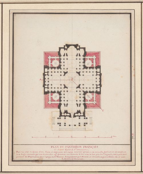
DR1995:0060
Description:
- The scale, section cuts and site lines on drawing DR1995:0060 also correspond to drawing DR1995:0061.
DR1995:0060
Description:
- The scale, section cuts and site lines on drawing DR1995:0060 also correspond to drawing DR1995:0061.
Personnes et institutions:
Sujet:
architecture
architecture
Date:
ca. 1797
ca. 1797
Titre:
Projet pour la transformation du Panthéon en pyramide : Plan / Project for the transformation of the Panthéon into a pyramid : Plan
Actions:
DR1995:0060
Description:
- The scale, section cuts and site lines on drawing DR1995:0060 also correspond to drawing DR1995:0061.
Projet pour la transformation du Panthéon en pyramide : Plan / Project for the transformation of the Panthéon into a pyramid : Plan
Actions:
DR1995:0060
Description:
- The scale, section cuts and site lines on drawing DR1995:0060 also correspond to drawing DR1995:0061.
Classification:
dessins
dessins
Date:
ca. 1797
ca. 1797
Personnes et institutions:
Sujet:
architecture
architecture
Classification:
dessins
dessins

Numéro de référence:
DR1987:0659
Description:
- This elevation indicates the proposed site for a future extension for Wayfarers' Chapel, Palos Verdes, California.
DR1987:0659
Description:
- This elevation indicates the proposed site for a future extension for Wayfarers' Chapel, Palos Verdes, California.
Personnes et institutions:
Sujet:
architecture
architecture
Date:
1955
1955
Titre:
Wayfarers' Chapel, Palos Verdes, California: Sketch elevation for the parish house
Actions:
DR1987:0659
Description:
- This elevation indicates the proposed site for a future extension for Wayfarers' Chapel, Palos Verdes, California.
Wayfarers' Chapel, Palos Verdes, California: Sketch elevation for the parish house
Actions:
DR1987:0659
Description:
- This elevation indicates the proposed site for a future extension for Wayfarers' Chapel, Palos Verdes, California.
Classification:
dessins
dessins
Date:
1955
1955
Personnes et institutions:
Sujet:
architecture
architecture
Classification:
dessins
dessins
Actions:
Numéro de référence:
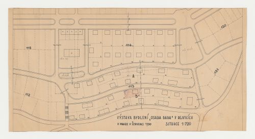
DR1984:1340
Description:
- Hatching in red ink with blue pencil on the site plan indicates the lot for Villa Palicka.
DR1984:1340
Description:
- Hatching in red ink with blue pencil on the site plan indicates the lot for Villa Palicka.
Personnes et institutions:
Sujet:
architecture, urbanisme
architecture, urbanisme
Date:
printed June 1930
printed June 1930
Titre:
Site plan for Baba Villa Colony showing the lot for Villa Palicka, Prague, Czechoslovakia (now Czech Republic)
Actions:
DR1984:1340
Description:
- Hatching in red ink with blue pencil on the site plan indicates the lot for Villa Palicka.
Site plan for Baba Villa Colony showing the lot for Villa Palicka, Prague, Czechoslovakia (now Czech Republic)
Actions:
DR1984:1340
Description:
- Hatching in red ink with blue pencil on the site plan indicates the lot for Villa Palicka.
Classification:
dessins
dessins
Date:
printed June 1930
printed June 1930
Personnes et institutions:
Sujet:
architecture, urbanisme
architecture, urbanisme
Classification:
photographies
photographies
Numéro de référence:
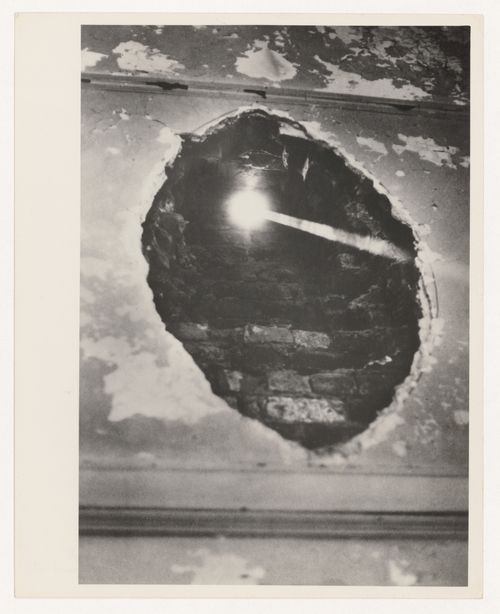
PH2006:0292
Description:
Photograph of site-specific installation by Alan Saret as part of MoMA PS1’s initial exhibition Rooms
PH2006:0292
Description:
Photograph of site-specific installation by Alan Saret as part of MoMA PS1’s initial exhibition Rooms
Personnes et institutions:
Date:
1976
1976
Titre:
The Hole at P.S.1, Fifth Solar Chthonic Wall Temple
Actions:
PH2006:0292
Description:
Photograph of site-specific installation by Alan Saret as part of MoMA PS1’s initial exhibition Rooms
The Hole at P.S.1, Fifth Solar Chthonic Wall Temple
Actions:
PH2006:0292
Description:
Photograph of site-specific installation by Alan Saret as part of MoMA PS1’s initial exhibition Rooms
Classification:
photographies
photographies
Date:
1976
1976
Personnes et institutions: