3801 Résultats
Classification:
photographies
photographies
Actions:
Numéro de référence:
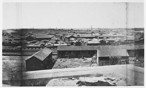
PH1986:0901:004:006
PH1986:0901:004:006
Personnes et institutions:
Sujet:
architecture, ingénierie, militaire, topographique
architecture, ingénierie, militaire, topographique
Date:
between 2 August and 4 August 1860
between 2 August and 4 August 1860
Classification:
photographies
photographies
Date:
between 2 August and 4 August 1860
between 2 August and 4 August 1860
Personnes et institutions:
Sujet:
architecture, ingénierie, militaire, topographique
architecture, ingénierie, militaire, topographique
Classification:
photographies
photographies
Actions:
Numéro de référence:
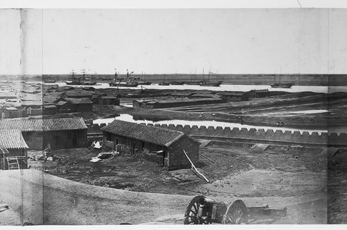
PH1986:0901:004:007
PH1986:0901:004:007
Personnes et institutions:
Sujet:
architecture, ingénierie, militaire, topographique
architecture, ingénierie, militaire, topographique
Date:
between 2 August and 4 August 1860
between 2 August and 4 August 1860
Classification:
photographies
photographies
Date:
between 2 August and 4 August 1860
between 2 August and 4 August 1860
Personnes et institutions:
Sujet:
architecture, ingénierie, militaire, topographique
architecture, ingénierie, militaire, topographique
Classification:
photographies
photographies
Actions:
Numéro de référence:
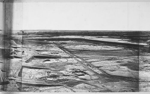
PH1986:0901:004:004
PH1986:0901:004:004
Personnes et institutions:
Sujet:
architecture, ingénierie, militaire, topographique
architecture, ingénierie, militaire, topographique
Date:
between 2 August and 4 August 1860
between 2 August and 4 August 1860
Classification:
photographies
photographies
Date:
between 2 August and 4 August 1860
between 2 August and 4 August 1860
Personnes et institutions:
Sujet:
architecture, ingénierie, militaire, topographique
architecture, ingénierie, militaire, topographique
Classification:
photographies
photographies
Actions:
Numéro de référence:
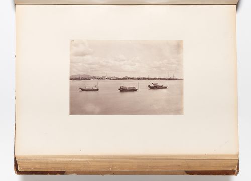
PH1981:0620:060
Description:
- A hand-written table of contents accompanies album PH1981:0620:001-081.
PH1981:0620:060
Description:
- A hand-written table of contents accompanies album PH1981:0620:001-081.
Personnes et institutions:
Sujet:
architecture
architecture
Date:
between 1859 and 1877
between 1859 and 1877
Titre:
Panoramic view of Canton (now Guangzhou) showing Shameen (now Shamian) Island and the Pearl River (also known as the Canton River, now Zhujiang), China
Actions:
PH1981:0620:060
Description:
- A hand-written table of contents accompanies album PH1981:0620:001-081.
Panoramic view of Canton (now Guangzhou) showing Shameen (now Shamian) Island and the Pearl River (also known as the Canton River, now Zhujiang), China
Actions:
PH1981:0620:060
Description:
- A hand-written table of contents accompanies album PH1981:0620:001-081.
Classification:
photographies
photographies
Date:
between 1859 and 1877
between 1859 and 1877
Personnes et institutions:
Sujet:
architecture
architecture
Classification:
photographies
photographies
Actions:
Numéro de référence:
PH1980:0814
PH1980:0814
Personnes et institutions:
Sujet:
ingénierie, topographique
ingénierie, topographique
Date:
1979
1979
Classification:
photographies
photographies
Date:
1979
1979
Personnes et institutions:
Sujet:
ingénierie, topographique
ingénierie, topographique
Classification:
photographies
photographies
Actions:
Numéro de référence:
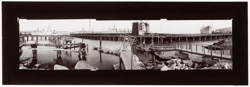
PH1984:0311
Description:
- This composite photograph is a view of China Basin harbour showing Mission Rock public launching ramp in the foreground, with Pier 52 from centre left to centre right, Pier 54 at upper right, and Mission Rock Terminal (also known as Pier 50) in the background from centre left to centre.
Personnes et institutions:
Sujet:
architecture, ingénierie, militaire
architecture, ingénierie, militaire
Date:
1982 or 1983
1982 or 1983
Titre:
Panoramic composite photograph of China Basin harbour showing piers, docks and ships, with Mission Rock Terminal (also known as Pier 50) in the background, San Francisco, United States
Actions:
PH1984:0311
Description:
- This composite photograph is a view of China Basin harbour showing Mission Rock public launching ramp in the foreground, with Pier 52 from centre left to centre right, Pier 54 at upper right, and Mission Rock Terminal (also known as Pier 50) in the background from centre left to centre.
Classification:
photographies
photographies
Date:
1982 or 1983
1982 or 1983
Personnes et institutions:
Sujet:
architecture, ingénierie, militaire
architecture, ingénierie, militaire
Classification:
dessins
dessins
Actions:
Numéro de référence:
PH1979:0603.03:003
PH1979:0603.03:003
Personnes et institutions:
Sujet:
architecture
architecture
Date:
published 1874
published 1874
Classification:
dessins
dessins
Date:
published 1874
published 1874
Personnes et institutions:
Sujet:
architecture
architecture
Classification:
photographies
photographies
Actions:
Numéro de référence:
PH1986:0901:023
Description:
- The inscription at l.c.: "The same", refers to photograph PH1986:0901:022 which immediately precedes this photograph in album PH1986:0901:001-045 and which is another view showing part of the Garden of the Clear Ripples [Qing Yi Yuan] (now known as the Summer Palace or Yihe Yuan). - The title of a published identical image, "The Great Imperial Palace, Yuen Ming Yuen, before the Burning, Pekin" is inaccurate, as Yuen Ming Yuen (now Yuanming Yuan) [Garden of Perfect Clarity], though near the Garden of the Clear Ripples [Qing Yi Yuan] (now known as the Summer Palace or Yihe Yuan), is a separate garden complex (Naquin, pp. 312-314).
Personnes et institutions:
Sujet:
architecture, architecture de paysage
architecture, architecture de paysage
Date:
between 6 October and 18 October 1860
between 6 October and 18 October 1860
Titre:
View of a building in Garden of the Clear Ripples [Qing Yi Yuan] (now known as the Summer Palace or Yihe Yuan), Peking (now Beijing), China
Actions:
PH1986:0901:023
Description:
- The inscription at l.c.: "The same", refers to photograph PH1986:0901:022 which immediately precedes this photograph in album PH1986:0901:001-045 and which is another view showing part of the Garden of the Clear Ripples [Qing Yi Yuan] (now known as the Summer Palace or Yihe Yuan). - The title of a published identical image, "The Great Imperial Palace, Yuen Ming Yuen, before the Burning, Pekin" is inaccurate, as Yuen Ming Yuen (now Yuanming Yuan) [Garden of Perfect Clarity], though near the Garden of the Clear Ripples [Qing Yi Yuan] (now known as the Summer Palace or Yihe Yuan), is a separate garden complex (Naquin, pp. 312-314).
Classification:
photographies
photographies
Date:
between 6 October and 18 October 1860
between 6 October and 18 October 1860
Personnes et institutions:
Sujet:
architecture, architecture de paysage
architecture, architecture de paysage
Classification:
photographies
photographies
Actions:
Numéro de référence:
PH1980:0206:001
PH1980:0206:001
Personnes et institutions:
Sujet:
architecture
architecture
Date:
between 1865 and 1874
between 1865 and 1874
Classification:
photographies
photographies
Date:
between 1865 and 1874
between 1865 and 1874
Personnes et institutions:
Sujet:
architecture
architecture
Classification:
photographies
photographies
Actions:
Numéro de référence:
PH1986:0901:007
Description:
- This photograph is the first in a series of views which Felice Beato made of the four Taku Forts (Harris, p. 139; Worswick, p. 138). The gate at c.l. is the point where the British forces entered the fort, while the French forces entered via the ladders at c.r. (Harris, p. 139).
Personnes et institutions:
Sujet:
architecture, ingénierie, militaire
architecture, ingénierie, militaire
Date:
between 22 August and 21 September 1860
between 22 August and 21 September 1860
Titre:
View of the ruins of the Upper North Taku Fort, showing an earthwork cavalier and defensive walls, Taku (now Dagu), near Tientsin (now Tianjin), China
Actions:
PH1986:0901:007
Description:
- This photograph is the first in a series of views which Felice Beato made of the four Taku Forts (Harris, p. 139; Worswick, p. 138). The gate at c.l. is the point where the British forces entered the fort, while the French forces entered via the ladders at c.r. (Harris, p. 139).
Classification:
photographies
photographies
Date:
between 22 August and 21 September 1860
between 22 August and 21 September 1860
Personnes et institutions:
Sujet:
architecture, ingénierie, militaire
architecture, ingénierie, militaire